EMBEDDING WEB-BASED GEOGRAPHIC INFORMATION SYSTEM
(WEB-BASED GIS) IN TEACHING AND LEARNING OF HISTORY
Rosilawati Zainol
1, Shakila Parween Yacob
21
Department of Urban and Regional Planning, Faculty of Built Environment, University of
Malaya, Kuala Lumpur (MALAYSIA)
2
Department of History, Faculty of Arts and Social Sciences, University of Malaya, Kuala
Lumpur (MALAYSIA)
Abstract
Current education system requires innovative approach in enhancing students’ understanding in any subjects. One of the innovative approaches that can be implemented in teaching and learning is web-based geographic information system (web-web-based GIS). Not only it is easy to use, it is also freely available online. Therefore this study explores the tools available in the current web-based GIS in teaching and learning of history subject. The method used in this study is through experiments in using the web-based GIS tools namely Google Earth in the Malaysian Form Five history curriculum. For each topic that requires the use of map, Google Earth tools are evaluated. Results show almost all tools available in Google Earth can be used in all topics that need the application of high-order thinking skills (HOTs). Therefore it is timely that web-based GIS is used as one of the innovative approaches used in education policy.
Keywords: web-based geographic information system (web-based GIS), history, innovative education, high-order thinking skills (HOTs), teaching and learning tool.
1 INTRODUCTION
The advancement in technology has changed people’s life in many ways. This includes education system in which methods of teaching and learning in the 21st century are now integrated with information communication technology (ICT). People who ignore the ICT wave will be left behind. ICT includes the use of technology such as computer, simulator, courseware, smart white board and also internet resources namely youtube, online library, online archive, geographic information system (GIS) and web-based geographic information system (web-based GIS). The integration of ICT in teaching and learning has taken place in many countries. Some of the integration projects might be successful but others might fail due to certain factors which include limited ICT skills, lack of pedagogic expertise, lack of passion, and lack of training (Chikasha et al., 2013; Hu & McGrath, 2011; Huynh et al., 2012). Teachers’ knowledge on ICT influences the teaching and learning (Hsu, 2011). Teachers only give assignments to students using tools that they are familiar. Therefore teachers’ exposure to ICT tools is essential in students’ education. Policy driven method can assist in the successful of ICT integration in teaching and learning (Hadjithoma & Karagiorgi, 2009). Nonetheless, teachers appreciate the availability of ICT which provide vast amount of resources for teaching and learning (Domingo & Marques, 2011). However, proper training need to be provided to teachers to expose them to new method in teaching and learning in the twenty first century.
Geographic information systems (GIS) is an application that has potential in enhancing teaching and learning of subjects that require spatial visualization especially history and geography. GIS can be taught as a separate subject or can be integrated into subjects and use it as a tool. However, Huynh et al. (2012) argue that the second method requires teachers to be trained first before handling the tool. This will be a challenging task since it is time consuming and teachers must be willing to learn new pedagogy technique. Another challenge in bringing GIS in education system is the cost of GIS software which is quite pricy (Singh et al., 2012). In facing these challenges, web-based geographic information system (web-based GIS) might be able to provide solutions. Therefore this study examines the use of web-based GIS in teaching and learning history, a subject that always said to be a boring one.
2 RESEARCH BACKGROUND
Web-based GIS is an extension of a GIS system that is able to run on a web browser. It doesn’t require additional software to be installed. It has a lot of benefits. Among others include interactive mapping, solid and geometric modelling, virtual reality modelling language and multi-user worlds (Doyle et al., 1998). Interactive mapping allows users to interact with the map. Web-based GIS provides solid and geometric modelling which allows the visualization looks real. The advancement of computer system has allowed three dimensional modelling to exist. In addition, web-based GIS application is able to support standard based inquiry method (Baker, 2005). Thus, it will create an interesting environment to users. The introduction of web-based GIS in education will provide additional tool for teachers to use. It will enhance students’ learning history (Lo et al., 2009).
Web-based GIS is freely available. It can be benefited by anyone in the world. However, the only limitation that might affect the application is internet access. In order for the system to run smoothly, internet access must be available at all time. A web-based GIS application should be able to ease the complexity of GIS application. Web-based GIS applications that are available currently include GoogleMap, Wikimapia, GoogleEarth, Microsoft Virtual Earth and ESRI's ArcGIS Explorer. Some of these applications have been evaluated by scholars.
The use of GIS and web-based GIS in teaching and learning has been implemented in a few countries such as Colombia and Portugal (Milson et al., 2012). Students are receptive to web-based learning (Clark et al., 2007). This application is able to enhance teachers’ and students’ skills (Rocha Salamanca & Diaz Vega, 2012). It is more of teaching with GIS rather than teaching GIS (Mota, 2012). The positive impact by the introduction of GIS in education cannot be denied. It is able to influence students ability to utilise higher order thinking skills (West, 2003) and improves their geographic knowledge and map skills (Shin, 2006).
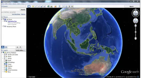
[image:2.595.68.529.425.682.2]GoogleEarth is a 3D web-based GIS application. It is an application that can be downloaded easily from http://www.google.com/intl/en/earth/. Its use in education is not new since there scholars who have examined the effectiveness of this application (Patterson, 2007). Figure 1 shows the globe at the opening page of GoogleEarth once it has completed installation process.
3 METHODOLOGY
This study uses quantitative approach. Three steps are employed to achieve its results. First, a section of form five Malaysian history syllabus is selected and examined. Chapters that require mapping application are chosen. Simultaneously, several web-based GIS applications are examined among them include GoogleMap, Wikimapia, Microsoft Virtual Earth and ESRI's ArcGIS Explorer and GoogleEarth. After running few tests, GoogleEarth is found to be the most suitable application. Then, tools available in GoogleEarth are embedded into the selected chapters in the curriculum.
4 RESULTS AND DISCUSSION
The form five history syllabus is divided into three main themes namely the emergence and development of nationalism until World War II, state and nation building towards emergence of Malaysia Sovereign and Malaysia and international community collaboration. The first theme is chosen. It discusses on the background of western imperialism in Southeast Asia, changes in political system with the introduction of western bureaucracy, nationalism in Southeast Asia and struggle against the colonizer. Each component of this theme is divided into three levels of understanding. Maps are required to plot the location of western countries and how they made their way to Southeast Asia. In addition, maps are also required to plot the chronology of each event. The location of Southeast Asia countries are also plotted against the surrounding areas.
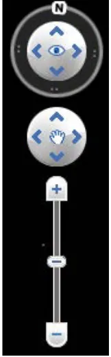
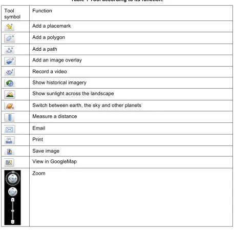
Tools in GoogleEarth have been examined. These tools are required to perform functions required in the teaching and learning tasks. Figure 2 shows the tools available in GoogleEarth. Besides these tools, GoogleEarth also provide zoom function to enable students to interact with the globe in GoogleEarth. Figure 3 shows the zoom function. Each tool has specific function (Table 1).
[image:3.595.257.338.439.699.2]Figure 2 Tools in GoogleEarth.
Table 1 Tool according to its function.
Tool symbol
Function
Add a placemark
Add a polygon
Add a path
Add an image overlay
Record a video
Show historical imagery
Show sunlight across the landscape
Switch between earth, the sky and other planets
Measure a distance
Save image
View in GoogleMap
Zoom
Embedding the tools available in GoogleEarth into the selected form five syllabus was carried out using matching technique. Not all the tools available are used in teaching and learning of history subject. The most important tools are placemark, polygon, path, image overlay, video recording, historical imagery, distance measuring and print.
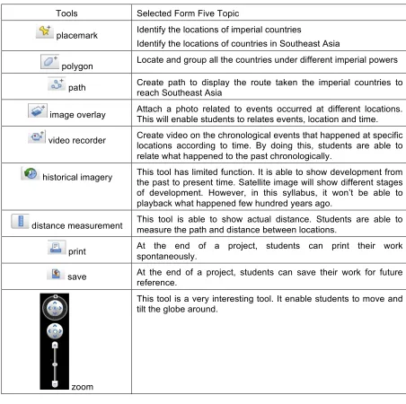
Table 2 The matching of tools and tasks in syllabus.
Tools Selected Form Five Topic
placemark Identify the locations of imperial countries
Identify the locations of countries in Southeast Asia
polygon Locate and group all the countries under different imperial powers
path Create path to display the route taken the imperial countries to reach Southeast Asia
image overlay Attach a photo related to events occurred at different locations. This will enable students to relates events, location and time.
video recorder Create video on the chronological events that happened at specific locations according to time. By doing this, students are able to relate what happened to the past chronologically.
historical imagery This tool has limited function. It is able to show development from the past to present time. Satellite image will show different stages of development. However, in this syllabus, it won’t be able to playback what happened few hundred years ago.
distance measurement This tool is able to show actual distance. Students are able to measure the path and distance between locations.
print At the end of a project, students can print their work spontaneously.
save At the end of a project, students can save their work for future reference.
zoom
This tool is a very interesting tool. It enable students to move and tilt the globe around.
The results of matching have highlighted three major points. Firstly, the tools are able to perform the objectives of the selected task. Due to its interesting outlook and outstanding functions GoogleEarth application will be receptive to the application as highlighted by Clarke et al. (2007). GoogleEarth will be able to attract students to use this application. They can use it to produce projects on their own. Furthermore, GoogleEarth provides tooltip at every tool on the map to ease learning process by teachers and also by students. As a result, this technique will solve teachers’ problems of lack of skills and training as highlighted by Chikasha, et al. (2013), Hu and McGrath (2011) and Huynh, et al. (2012). GoogleEarth provides interactive platform to users and they have freedom on how to use the tools effectively. It is a true teaching with GIS rather than teaching GIS as mentioned by Mota (2012).
5 CONCLUSION
REFERENCES
[1] Baker, T. R. (2005). Internet-Based GIS Mapping in Support of K-12 Education. The Professional Geographer, 57(1), 44-50. doi: 10.1111/j.0033-0124.2005.00458.x
[2] Chikasha, S., Ntuli, M., Sundarjee, R., & Chikasha, J. (2013). ICT integration in teaching: An uncomfortable zone for teachers: A case of schools in Johannesburg. Education as Change, 18(1), 137-150. doi: 10.1080/16823206.2013.847013
[3] Clark, A. M., Monk, J., & Yool, S. R. (2007). GIS Pedagogy, Web-based Learning and Student Achievement. Journal of Geography in Higher Education, 31(2), 225-239. doi:
10.1080/03098260601063677
[4] Domingo, M., & Marques, P. (2011). Classroom 2.0 Experiences and Building on the Use of ICT in Teaching. Comunicar(37), 169-174. doi: 10.3916/c37-2011-03-09
[5] Doyle, S., Dodge, M., & Smith, A. (1998). The potential of Web-based mapping and virtual reality technologies for modelling urban environments. Computers, Environment and Urban Systems, 22(2), 137-155.
[6] Hadjithoma, C., & Karagiorgi, Y. (2009). The use of ICT in primary schools within emerging communities of implementation. Computers & Education, 52(1), 83-91. doi:
http://dx.doi.org/10.1016/j.compedu.2008.06.010
[7] Hsu, S. (2011). Who assigns the most ICT activities? Examining the relationship between teacher and student usage. Computers & Education, 56(3), 847-855. doi:
http://dx.doi.org/10.1016/j.compedu.2010.10.026
[8] Hu, Z., & McGrath, I. (2011). Innovation in higher education in China: are teachers ready to integrate ICT in English language teaching? Technology Pedagogy and Education, 20(1), 41-59. doi: 10.1080/1475939x.2011.554014
[9] Huynh, N., Sharpe, B., Charman, C., Tong, J., & Greensmith, I. (2012). Canada: Teaching Geography Through Geotechnology Across a Decentralized Curriculum Landscape. In A. J. Milson, A. Demirci & J. J. Kerski (Eds.), International Perspectives on Teaching and Learning with GIS in Secondary Schools (pp. 37-47): Springer Netherlands.
[10] Lo, J.-J., Chang, C.-J., Tu, H.-H., & Yeh, S.-W. (2009). Applying GIS to develop a web-based spatial-person-temporal history educational system. Comput. Educ., 53(1), 155-168. doi: 10.1016/j.compedu.2009.01.016
[11] Milson, A. J., Demirci, A., & Kerski, J. J. (Eds.). (2012). International Perspectives on Teaching and Learning with GIS in Secondary Schools.
[12] Mota, M. (2012). Portugal: Experimental Science Learning, WebGIS, and the ConTIG Project. In A. J. Milson, A. Demirci & J. J. Kerski (Eds.), International Perspectives on Teaching and Learning with GIS in Secondary Schools (pp. 201-206): Springer Netherlands.
[13] Patterson, T. C. (2007). Google Earth as a (Not Just) Geography Education Tool. Journal of Geography, 106(4), 145-152. doi: 10.1080/00221340701678032
[14] Rocha Salamanca, L., & Diaz Vega, N. (2012). Colombia: Development of a Prototype Web-Based GIS Application for Teaching Geography. In A. J. Milson, A. Demirci & J. J. Kerski (Eds.), International Perspectives on Teaching and Learning with GIS in Secondary Schools (pp. 65-71): Springer Netherlands.
[15] Shin, E.-K. (2006). Using Geographic Information System (GIS) to Improve Fourth Graders' Geographic Content Knowledge and Map Skills. Journal of Geography, 105(3), 109-120. doi: 10.1080/00221340608978672
[16] Singh, S. S. B., Kleeman, G., & Van Bergen, P. (2012). Opportunities To Implement GIS In Teaching And Learning Geography: A Survey Among Smart Schools In Sabah, Malaysia. In Z. Bekirogullari (Ed.), International Conference on Education & Educational Psychology (Vol. 69, pp. 884-889).