http://dx.doi.org/10.4236/acs.2014.43036
How to cite this paper: Zoljoodi, M. and Didevarasl, A. (2014) Water-Level Fluctuations of Urmia Lake: Relationship with the Long-Term Changes of Meteorological Variables (Solutions for Water-Crisis Management in Urmia Lake Basin). Atmos-pheric and Climate Sciences, 4, 358-368. http://dx.doi.org/10.4236/acs.2014.43036
Water-Level Fluctuations of Urmia Lake:
Relationship with the Long-Term Changes
of Meteorological Variables (Solutions for
Water-Crisis Management in Urmia
Lake Basin)
Mojtaba Zoljoodi
1, Ali Didevarasl
2*1Iranian National Institute for Oceanography and Atmospheric Science, Tehran, Iran
2Atmospheric Sciences and Meteorological Research Center, Tehran, Iran
Email: *ali_didehvar714@yahoo.com
Received 23 April 2014; revised 20 May 2014; accepted 16 June 2014
Copyright © 2014 by authors and Scientific Research Publishing Inc.
This work is licensed under the Creative Commons Attribution International License (CC BY).
http://creativecommons.org/licenses/by/4.0/
Abstract
Urmia Lake in northwest of Iran, through the recent years has been extremely faced with the wa-ter crisis. Climate variations and anthropogenic impacts could be two main affiliated factors in this regard. We considered the long term data series of precipitation, temperature and evaporation in monthly and yearly scales in order to compare to water-level values of Urmia Lake. The statistics approaches such as: standard deviation, trend analysis, T test, Pearson and Spearman correlations, liner regression are used to analyze all variables. The results released that the water-level of Ur-mia Lake along with the precipitation and temperature of the lake’s basin have experienced the periodic changes through 1961 to 2010, as there are some gradual dryness trends on the study area according to precipitation and temperature variations. Urmia Lake periodic water-level fluc-tuations show more significant correlation to temperature than the precipitation. Whiles, the wa-ter-level’s decreasing behavior especially through 1998 to 2010 is more harsh and different than the rate that is considered for precipitation’s decrease and temperature’s increase. Thus, there could be some anthropogenic factors in the basin which produced some supplementary causes to shrink Urmia Lake. Extracting the double precipitation over the basin through introducing and categorizing of atmospheric synoptic systems in order to cloud seeding operation could be one of urgent and innovative solutions to mitigate water crisis in the basin.
359
Keywords
Urmia Lake, Water-Level Fluctuation, Climate Variations, Water Crisis, Anthropogenic Impacts, Cloud Seeding Operation
1. Introduction
Urmia Lake is a hyper-saline lake in northwestern Iran near Iran’s border with Turkey. The lake is between the Iranian provinces of East Azerbaijan and West Azerbaijan. It is the largest lake in the Middle East and the third largest saline lake on earth [1], with a surface area of approximately 5200 km2 (2000 mile2), 140 km (87 mi) length, 55 km (34 mi) width, and 16 m (52 ft) depth
[image:2.595.203.428.305.660.2]Especially during the recent years Urmia Lake extremely has been shrunk and its water-level has illustrated negative trends, as these conditions damaged considerably the ecosystems, environment and socio-economic ac-tivities of the local communities, within and around this lake [2]. Periodic changes in climatic and hydrologic variables that cause wide climate changes as well as droughts worldwide and in Iran seem to have a crucial im-pact in water crisis of Urmia Lake (Figure 1 and Figure 2).
Figure 1. Monthly values of temperature anomaly (top) and precipitation amount (bottom) in northwest of Iran during 1980-2010 (source; NOAA1). Note: increase of temperature
and decrease of precipitation through 2000-2010.
Figure 2. Satellite images of Urmia Lake in 1989 (right), 2001 (center) and 2011 (left): these images obviously show the negative trend of water-level and gradually shrinking of the lake through 22 years (source: U.S. Geological Survey).
Some researchers have illustrated this fact that the water-level of Urmia Lake consistently have been changing through historical periods, although there is not any agreement between the researchers about the trend and in-tensity of these changes. As an example, Jabbarlu-Shabestary in 2000 [3] through a research has found that in 5 - 10 thousand years ago water-level of the lake fell down more than the current position. The results derived from a paleoclimatic investigation on the lake bed by Ali mohammadi et al., 2011 [4] indicated that the lake had nev-er been dried through 23 - 40 thousand years ago, whnev-ereas all investigations and data snev-eries confirm seasonal and periodic fluctuations in the lake’s water-level.
Figure 3 shows the yearly changes of the lake’s water-level in a 45-year period (1966-2010). From 1998 ex-tremely water-level of Urmia Lake has been decreased below its long-term normal level (1275.35 m).
Maximum depth of the lake measured about 16 m, and it’s water-level is based on the mean sea level (MSL) varies between 1272 m - 1278 m [5].
If the height of 1274.1 m for Urmia Lake’s water-level considered the crisis threshold, the surface area of the lake should be about 5700 km2[6], whereas, currently the lake is shrunk up to a surface almost 3000 km2[7].
Satellite images analysis in order to derive the shore line’s changing illustrated a wide range of seasonal/pe- riodic variations in the surface of the lake during the recent decade. Maximum changes happened because of de-creasing the lake’s water-level up to 3.5 m from normal, and then resulted in basic shifts over shore lines in par-ticularly on the southeastern and eastern coasts. Appearance of such significant water-level fluctuations caused the shrinking of Urmia Lake up to 23%, so the environmental feedbacks of these critical conditions threat se-riously the valuable ecosystems of the lake [8].
Different investigations indicate relative dependency between ecological status of lakes and climatologic changes. As an example, Kebede, S., et al. in 2006 [9] found around 20% changes in climatologic variables over Tana Lake basin through a 50-year period, although water-level of the lake has been remained stable. In the case of Aral Lake the climate effect is estimated about 14% versus 86% of man-made impact on water-level varia-tions [10] [11]. The studies by Lofgren et al. (2002) [12], through a hydrological modeling suite using input data from the CGCM1(The first version of the Canadian Global Coupled Model) predict large drops in lake levels, up to a maximum of 1.38 m on Lakes Michigan and Huron by 2090.
A developed research by Tabari and Ghalehni, 2012 [13], on water-need of Urmia lake shows an extreme in-creasing trend in water-need of this lake due to recent droughts. It is notable that the water influx to Urmia Lake in the recent years decreased considerably up to 77%, so this critical condition of the lake doesn’t seem to hap-pen only by climatic effects, regarding the fact that the wide constructive operations and developmental projects are in performance over the Urmia Lake basin.
2. Study Area
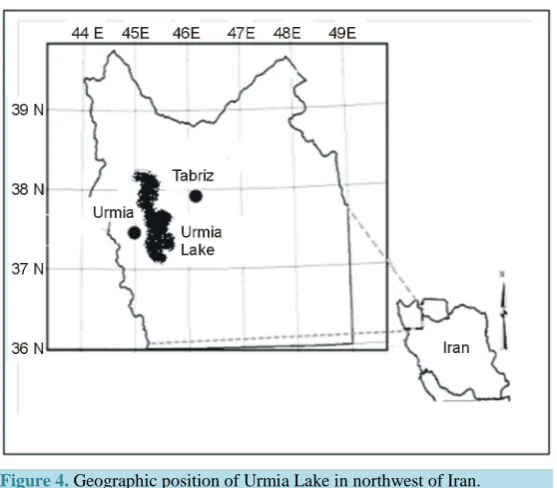
Urmia Lake, located in northwestern of Iran in a geographic position between 45˚E - 46˚E and 37˚4'N - 38˚17'N, is an oligotrophic lake of thalassohaline origin with a total surface area between 4750 and 6100 km2 and a maximum depth of 16 m at an altitude of 1250 m [14]-[16] (Figure 4).
Jan 1989 Dec 2001
Figure 3. Water-level fluctuations of Urmia Lake during 1966-2010 (based on height from mean sea level, in meter).
Figure 4.Geographic position of Urmia Lake in northwest of Iran.
The total catchment area of the lake is about 51,876 Km2 which is 3.15% of that of the entire country, and in-cludes 7% of the total surface water in Iran. There are thirteen main rivers in the lake basin, among them Zarri-neh rood, the largest with a total annual discharge value of about 2 × 10⁹ m3[17] [18]. Climate in the Urmia Lake basin is harsh and continental, affected mainly by the mountains surrounding the lake [17] [19]. Consider-able seasonal fluctuations in air temperature occur in this semi arid climate with an annual average precipitation of between 200 and 300 mm [20]. The air temperature usually ranges between 0˚C and −20˚C in winter and up to 40˚C in summer. From this point of view, Urmia Lake is a critical asset for the region, because it acts to mod-erate these extremes [21]. Annual inflow into the lake is 6900 × 106 m3, of which 4900 × 106 m3 is from rivers, 500 × 106 m3 from flood water (through rainfall) and 1500 × 106 m3 from precipitation [22]. Underground springs are also a source of water, but the volume is not known [23].
3. Material and Methods
Firstly, all synoptic stations on the Urmia Lake basin and surrounding areas, have been taken in consideration, then we selected four stations, which provide long-term data series (50-year data availability) and fully cover the
1270 1271 1272 1273 1274 1275 1276 1277 1278
1966 1968 1970 1972 1974 1976 1978 1980 1982 1984 1986 1988 1990 1992 1994 1996 1998 2000 2002 2004 2006 2008 2010
w
ate
r-le
ve
l e
le
vat
io
n (
m
).
[image:4.595.175.454.290.534.2]basin, including Tabriz in east, Saghez in south, Urmia and Khoy respectively in west and northwest of the basin (Table 1). The meteorological variables including precipitation, temperature and evaporation through the aforementioned stations have been provided. Precipitation and temperature monthly data series were available over 1961 to 2010, but for evaporation data series; the longest available period covers only from 1990 to 2010.
The water-level monthly data series of Urmia Lake also during a 45-year period from 1966 to 2010 have been obtained through the regional water resource administration of West Azerbaijan province.
In the next step, a data bank in SPSS and Excel software has been designed. We refined all data series and then arranged them in monthly and yearly scales.
In order to find the amount and severity of yearly and monthly changes in the variables and setting those in a comparable frame, all data series have been standardized via the relation below:
1) Standardizing equation:
x
z µ
σ − =
where: x = the variables, µ = a long-term average, σ = standard deviation. 2) Average:
x N µ=Σ
where: N = number of the variables. 3) Standard deviation:
(
)
2x
N
µ σ = Σ −
Then, trend test and standard deviation analysis have been applied, also to compare the periodic changes of all data series we applied T test. Additionally, Correlation and linear regression analysis have been used to estimate the compatibility between all hydro-meteorological variables.
4. Results
1) Trend test and standard deviation analysis:
To estimate the severity of long term changes of all variables, firstly in each four selected stations the Trend analysis to the data series during a long period has been applied. All four stations illustrated rising trends for temperature and decreasing trends for the precipitation, whereas Tabriz synoptic station in the eastern part of basin shows more extreme trends than the 3 further stations of the study area. As in Tabriz station the decreasing trend of precipitation is estimated about −69, along with the growing trends of temperature and evaporation re-spectively +0.92 and +0.8. The standard deviation analysis in all selected stations confirms the existence of high temporal variability for precipitation comparing to temperature. The Percent of normal of standard deviations, confirms more harsh fluctuations for precipitation, which could potentially imply the effective role of precipita-tion’s departure from normal in happening of severe droughts over the study area. Urmia Lake’s water-level also indicates a falling trend around −0.76, with a standard deviation of 30%.
[image:5.595.89.539.636.721.2]Basically, based on the outputs of the trend test and standard deviation analysis, climatic dryness over the ba-sin has been expanded, so these conditions could influence water inflow to the lake as well as water level of the lake through direct evaporation (Table 2).
Table 1. Position of the selected stations on the study area (Urmia basin).
Stations Elevation (in meter) Longitude Latitude
Tabriz 1361 46˚17′ 38˚05′
Urmia 1315.9 45˚5' 37˚32'
Saghez 1522.8 46˚16' 36˚15'
Table 2. The results derived through trend and standard deviation analyzes in four selected stations on Urmia Lake basin.
Stations Precipitation Trend Precipitation Stdv. % Temperature Trend Temperature Stdv. % Evaporation Trend Evaporation Stdv. %
Tabriz −0.69 30% +0.92 7.5% +0.8 9.5%
Urmia −0.12 31.6% +0.07 9% +0.12 8%
Saghez −0.32 28.76% +0.28 11.8% +0.3 18.4%
Khoy −0.38 28% +0.48 9.8% +0.4 9.8%
2) Monthly and yearly changes of the hydro-meteorological variables:
Monthly trend analysis on all variables indicates some notable results, as monthly decreasing trends of preci-pitation along with rising trends of temperature and evaporation are evident for majority of months; the wa-ter-level of Urmia Lake in all months of year shows persistent negative trends. The severity of precipitation-fall and rising of temperature as well as evaporation over Jan to Jun is considered more than what is found for Jul to Dec, on the contrary, decreasing trend of water-level over Jul to Dec shows more severity (Figure 5). Thus we did not find a seasonal correspondence between meteorological indicators over the basin and water-level varia-tions of the Lake.
Yearly standardized values of precipitation, temperature and water-level of Urmia Lake through 1966 to 2010, illustrate a more fluctuant behavior for the meteorological factors (temperature and precipitation) than the wa-ter-level. From 1995 water-level indicates a steady decreasing trend, as through 1998-2010 it goes extremely below normal. Also, from 1995 to 2010 temperature is raised above normal and precipitation shows a decreasing behavior, so their peak is found over 1996 to 2002, although their intensities are significantly weak by compar-ing to the fallcompar-ing rate of water-level of Urmia Lake, and both of those (temperature and precipitation) vary al-most around normal especially through 2002 to 2010 (Figure 6).
Regarding the results, it is notable that the water-level of Lake in particular from 1998 to 2010 through all months of year has been slumped harshly and unnaturally, while precipitation and temperature released compa-ratively more different and poor changes.
3) Comparison of periodic changes in precipitation, temperature and water-level of Urmia Lake:
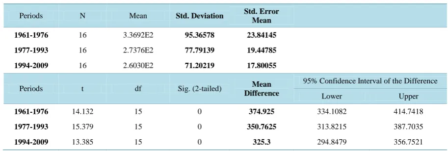
In order to understand the rate and modality of periodic changes of the variables a T test analysis has been ap-plied, as the entire study period is divided into three spells for comparing them. About precipitation, by compar-ing the mean value of the recent 16-year spell (1994 to 2009) to the first one (1961 to 1976) we found precipita-tion declines on the basin around 76 mm, so precipitaprecipita-tion’s mean value on the basin from 336 mm in 1961-1976, decreased to 273 mm in 1977-1993 and 260 mm in 1994-2009 (Table 3). Temperature also shows a significant increasing trend on the basin, as in total we have found around 1.39˚C grow in temperature’s mean by compar-ing the recent 16-year period (1994 to 2009) to 1961-1976. Mean value of temperature in 1961-1976 was 12˚C that is reached 12.45˚C in 1977-1993 and 13.39˚C in the recent spell of 1994-2009 (Table 4).
The standard deviations and standard mean errors of precipitation and temperature data series during the 3 mentioned spells gradually are declining along with the variations of mean values, and illustrating the persis-tency and extremity of the dryness on the basin especially over the recent 16-year spell, by low positive and negative fluctuations parallel to a falling behavior of precipitation and an increasing behavior of temperature (Table 3 and Table 4).
T test analysis on water-level of Urmia Lake released a decrease around 2 m through 1996 to 2010 comparing to the previous spell (1981-1995). The water-level of Urmia Lake based on the mean sea level, through 1966 to 1980 averagely was around 1275.7 m, and then it is increased to 1276.14 m in 1981-1995, whiles it is decreased extremely to 1274.17 m in 1996-2010. Although standard deviations and standard mean errors significantly in-dicated a rising trends which could imply the persistent slumping of the lake’s water level through 1996 to 2010, as the water level of the lake from 1278 m in 1996 reached 1271.5 m in 2010 (Table 5).
4) Correlation and liner regression analyze between water-level of Urmia Lake with temperature and precipi-tation data series:
−0.5, whiles the combination of precipitation and water-level shows poor correlation ranks (in max 0.18) (Table 6). Regression analysis also confirmed significant relationship for 3-year accumulated water-level values and temperature, with a R2 rank of 0.22 (Table 7 and Figure 7). Thus these results may imply a more significant pe-riodic impact of temperature to water-level variations of the lake comparing to precipitation.
[image:7.595.183.445.145.302.2]Figure 5. Monthly trend analysis on precipitation, temperature, evapo-ration and water-level during a long-term period.
Figure 6. Comparing the yearly changes of precipitation, temperature and water- level of Urmia Lake during 1966 to 2010.
Table 3. The results derived through T test on precipitation data series of the watershed in three 16-year spells (through 1961 to 2009).
Periods N Mean Std. Deviation Std. Error Mean
1961-1976 16 3.3692E2 95.36578 23.84145
1977-1993 16 2.7376E2 77.79139 19.44785
1994-2009 16 2.6030E2 71.20219 17.80055
Periods t df Sig. (2-tailed) Mean
Difference
95% Confidence Interval of the Difference
Lower Upper
1961-1976 14.132 15 0 374.925 334.1082 414.7418
1977-1993 15.379 15 0 350.7625 313.8215 387.7035
1994-2009 13.385 15 0 325.3 294.8479 356.7521
-1 -0.8 -0.6 -0.4 -0.2 0 0.2 0.4 0.6
1 2 3 4 5 6 7 8 9 10 11 12
tr
end
months
water level precipitation temperature evaporation
-2.5 -2 -1.5 -1 -0.5 0 0.5 1 1.5
1966 1969 1972 1975 1978 1981 1984 1987 1990 1993 1996 1999 2002 2005 2008
st
anda
rd v
al
ue
s
year
[image:7.595.161.465.337.510.2] [image:7.595.83.540.568.722.2]Table 4. The results derived through T test on temperature data series of the watershed in three 16-year spells (through 1961 to 2009).
Periods N Mean Std. Deviation Std. Error Mean
1961-1976 16 12.0267 0.92421 0.23105
1977-1993 16 12.4541 0.70933 0.17733
1994-2009 16 13.3933 0.69768 0.17442
Periods t df Sig. (2-tailed) Mean
Difference
95% Confidence Interval of the Difference
Lower Upper
1961-1976 52.052 15 0 12.02669 11.5342 12.5192
1977-1993 70.23 15 0 12.45407 12.0761 12.832
[image:8.595.86.540.285.424.2]1994-2009 76.788 15 0 13.39329 13.0215 13.7651
Table 5. The results derived through T test on water-level data series of the watershed in three 15-year spells (through 1966 to 2009).
Periods N Mean Std. Deviation Std. Error Mean
1966-1980 15 1.28E+03 0.89083 0.23001
1981-1995 15 1.28E+03 0.80487 0.20782
1996-2010 15 1.27E+03 1.96535 0.50745
Periods t df Sig. (2-tailed) Mean
Difference
95% Confidence Interval of the Difference
Lower Upper
1966-1980 5.55E+03 14 0 1275.74133 1275.248 1276.2347
1981-1995 6.14E+03 14 0 1276.144 1275.6983 1276.5897
1996-2010 2.51E+03 14 0 1274.17933 1271.091 1275.2677
Table 6. Pearson correlation (top) and spearman correlation (bottom) between water-level with temperature and precipita-tion.
Water-Level Water 3 Rain 3-Rain Temp 3-Tempt
Water-Level
Pearson
Correlation 1 0.956
**
0.073 0.098 −0.335* −0.251
Sig. (2-tailed) 0 0.632 0.524 0.024 0.096
N 45 45 45 45 45 45
Water-Level 3-Year Moving Average
Pearson
Correlation 0.956
** 1 0.213 0.139 −0.476** −0.433**
Sig. (2-tailed) 0 0.16 0.362 0.001 0.003
N 45 45 45 45 45 45
Water-Level Water 3 Rain 3-Rain Temp 3-Tempt
Water-Level
Spearman
Nonparametric
Correlation
1 0.900** 0.004 0.117 −0.374* −0.198
Sig. (2-tailed) . 0 0.98 0.443 0.011 0.192
N 45 45 45 45 45 45
Water-Level 3-Year Moving Average Spearman Nonparametric Correlation
0.900** 1
0.184 0.132 −0.539** −0.407**
Sig. (2-tailed) 0 . 0.227 0.386 0 0.006
N 45 45 45 45 45 45
[image:8.595.86.541.460.710.2]Table 7.Out puts obtained through linear regression analysis between water-level of Urmia Lake and the variables.
Equation Model Summary Parameter Estimates
R Square F df1 df2 Sig. Constant b1
Linear 0.112 5.441 1 43 0.024 0.023 −0.328
The independent variable is temperature. Dependent Variable: water level.
Equation Model Summary Parameter Estimates
R Square F df1 df2 Sig. Constant b1
Linear 0.227 12.629 1 43 0.001 −0.001 −0.477
The independent variable is temperature. Dependent Variable: water-level 3-year moving average.
Equation Model Summary Parameter Estimates
R Square F df1 df2 Sig. Constant b1
Linear 0.045 2.044 1 43 0.16 −0.031 0.266
The independent variable is precipitation. Dependent Variable: water-level 3-year moving average.
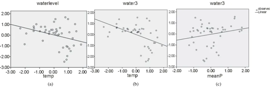
[image:9.595.90.537.304.448.2](a) (b) (c)
Figure 7. Linear regression analysis between water-level and temperature (a); water-level 3-year moving average and tem-perature (b); water-level 3-year moving average and precipitation (c).
Precipitation in general through its produced runoff on the basin, feeds the lake, whiles the runoff extremely has been reserved and controlled by dams and irrigation channels especially through 15 recent years on the Ur-mia Lake basin. On the contrary, increase of temperature could directly and indirectly affects the water-level of the Lake by raising evaporation as well as water-use rate in agricultural and urban affairs, etc.
Existence of the man-made factors on the basin [Annex] that intensify the water crisis of Urmia Lake could result in a poor consistency between water-level fluctuations of the lake and the changes of meteorological va-riables (although temperature seems to be more correlated to the water-level, nonetheless the ranks estimated remain always poor). As the low linear correlation estimated ranks don’t imply application possibility of predic-tion scenarios for the lake’s water-level behavior based on the precipitapredic-tion and temperature of the basin.
5. Conclusions
Correlation and regression analysis also indicated more significant compatibility between periodic changes of the water-level of Urmia Lake and temperature than the precipitation on its basin. This is because of 1) more chaotic and complicated behavior of the precipitation; and 2) runoff produced by precipitation on the basin ex-tremely is reserved beyond the dams, and disorderly feeds the lake. On the contrary, temperature with a more regular seasonal cycle could significantly affect the water-level of Lake by evaporation and raising the water-use rate on the basin.
The unnatural shrinking of Urmia Lake especially through the recent decade could imply existence of some anthropogenic factors such as: extraordinarily reserving the runoff and construction of dams on the rivers of the basin, over-developing of agriculture and industries on the upstream areas, hyper exploitation of groundwater via deep wells, population growth followed by increase of water use on the basin, construction of a causeway through Urmia Lake that disturbed the normal water cycles of the Lake, etc. [Annex], which could be considered the supplementary causes in recent water crisis of the Lake.
To cope with the current water crisis of Urmia Lake, there could be some management/mitigation plans re-lated to the constructional and natural systems of the basin. One of the imaginable urgent plans in this case, is the finding of the effective synoptic systems with relating to heavy precipitation over the basin in order to rec-ommend the best time for cloud seeding operations, and then extracting the double water perceptible over the basin.
References
[1] Jahanbakhsh, S., Adalatdost, M. and Tadayoni, M. (2011) Urmia Lake: The Relationship between Sunspots and Cli-mate on the Northwestern of Iran. Geographic Researches Quarterly, 25, 16656-16684.
[2] Mahmoei, H.B., Darvish, M., Fathollahzadeh, H. and Mosayebi, M. (2012) Lake Urmia Water Level Variability, Weather and Climate Change. Proceedings of National Conference on Climate Changes and Its Environmen-tal—Agricultural Impacts. July 2012, Urmia, 727-734.
[3] Shabestari, J.B. (2000) Study of the Water-Level Fluctuations of Urmia LAKE during Quaternary Period. First Con-gress of Urmia Lake, Iran.
[4] Mohammadi, A., Darvishi, J. and Lak, R. (2010) Study of the Sedimentation History of Urmia Lake Based on the Se-dimentary Samples of the Southwestern Bed of the Lake. 29th Congress of Earth Sciences, Iran.
[5] Jalili, S., Morid, S., Banakar, A. and ghanbari, N.R. (2011) Evaluate the Impact of Climate Indices: NAO and SOI, to Water-Level Fluctuations of Urmia Lake through Spectral Analysis Methods. Soil and Water Journal, 25, 140-149. [6] Eimanifar, A. and Mohebbi, F. (2007) Urmia Lake (Northwest Iran): A Brief Review. Saline Systems, 3, 5.
[7] Reveshty, M.A. and Maruyama, Y. (2010) Study of Uremia Lake Level Fluctuations and Predict Probable Changes Using Multi-Temporal Satellite Images and Ground Truth Data Period (1976-2010) New Challenge about Climate Change or Human Impact. Map Asia 2010, Malaysia.
[8] Rasouly, A.A. (2008) Monitoring the Water-Level Fluctuations of Urmia Lake through Satellite Images Analysis.
Proceedings of 3th Conference of Water Resources Management in Iran, Tabriz University, 137-165.
[9] Kebede, S., et al. (2006) Water Balance of Lake Tana and Its Sensitivity to Fluctuations in Rainfall, Blue Nile Basin, Ethiopia. Journal of Hydrology, 316, 233-247. http://dx.doi.org/10.1016/j.jhydrol.2005.05.011
[10] Benduhn, F. and Renard, P. (2004) A Dynamic Model of the Aral Sea Water and Salt Balance. Journal of Marine Sys-tems, 47, 35-50. http://dx.doi.org/10.1016/j.jmarsys.2003.12.007
[11] Beek, T., Voss, F. and Floerke, M. (2010) Modelling the Influence of Irrigation on the Shrinking Aral Sea. Geophysi-cal Research Abstracts, 12, (Page).
[12] Lofgren, B.M., Quinn1, F.H., Clites, A.H., Assel, R.A., Eberhardt, A.J. and Luukkonen, C.L. (2002) Evaluation of Po-tential Impacts on Great Lakes Water Resources Based on Climate Scenarios of Two GCMs. Journal of Great Lakes Research, 28, 537-554. http://dx.doi.org/10.1016/S0380-1330(02)70604-7
[13] Tabari, M.R. and Ghalehni, M.E. (2012) Evaluation of Urmia Lake’s Water-Need during the Recent Droughts. Pro-ceedings of 9th International Congress of Civil Engineering, Isfahan Technology University, May 2012, 1025-1032. [14] Takami, G.A. (1993) Urmiah Lake as a Valuable Source of Artemia for Feeding Sturgeon Fry. J Vet Fac Univ Tehran,
47, 2-14.
[16] Van Stappen, G., Fayazi, G. and Sorgeloos, P. (2001) International Study on Artemia LXIII. Field Study of the Artemia urmiana (Günther, 1890) Population in Lake Urmiah, Iran. Hydrobiologia, 466, 133-143.
http://dx.doi.org/10.1023/A:1014510730467
[17] Ghaheri, M.H. and Baghal-Vayjooee, N.J. (1999) Lake Urmia, Iran: A Summary Review. International Journal of Salt Lake Research, 8, 19-22. http://dx.doi.org/10.1007/BF02442134
[18] Alipour, S. (2006) Hydrochemistry of Seasonal Variation of Urmia Salt Lake, Iran. Saline Systems, 2, 9. http://dx.doi.org/10.1186/1746-1448-2-9
[19] Kelts, K. and Shahrabi, M. (1986) Holocene Sedimentalogy of Hypersaline Lake Urmia, Northwestern Iran. Paleogeo- graphy, Paleoclimatology, Paleoecology, 54, 105-130. http://dx.doi.org/10.1016/0031-0182(86)90120-3
[20] Touloie, J. (1998) Hydrogeochemistry of Urmia Lake. The 1st Oceanology Conference of Iran, Tehran, 20-23.
[21] Street-Perrott, F.A. and Roberts, N. (1983) Fluctuation in Closed-Basin Lakes as an Indicator of Past Atmospheric Cir- culation Patterns. In: Street-Perrott, F.A., Beran, M. and Ratcliffe, R., Eds., Variation in the Global Water Budget, Rei- del, Dordrecht, 331-345.
[22] Jalali, B. (1984) A Report on Urmia Lake. Ministry of Energy, Tehran.
currently publishing more than 200 open access, online, peer-reviewed journals covering a wide range of academic disciplines. SCIRP serves the worldwide academic communities and contributes to the progress and application of science with its publication.
Other selected journals from SCIRP are listed as below. Submit your manuscript to us via either