© 2016, IRJET | Impact Factor value: 4.45 | ISO 9001:2008 Certified Journal | Page 2277
GPS-GSM BASED TRACKING SYSTEM FOR SPECIAL USER GROUPS
P.SWAPNA
Pg scholar -computer science engineering department
K.L.N.College of Engineering,Sivagangai-630612,Tamilnadu, India
---***---Abstract -
Tracking system is mainly used for anti- theftsystem using GSM-GPS technology. This paper is mainly designed for special user groups to track the bus and move to their planned destination. Here, the GPS-GSM is the main part of this design; it will continuously monitor a moving bus and report the status of the vehicle to the special user. These systems continuously watch a moving bus and report the status to the blind person according to their request. The methodology involves three major modules, firstly the blind person unit sends the request through the zigbee to the bus stop unit, and subsequently the bus stop unit gets information through the satellite using the GPS from the bus driver unit, finally the blind person takes the correct bus parked in front of the user using a two way voice conversation. The special user groups gives the input about the place through the microphone used for receiving the command and GPS used to transmit the latitudes and longitudes of the precise location of the bus.
Keyword: GPS-GSM, Zigbee, microcontroller,
microphone.
1.
INTRODUCTION
People with disabilities like blind and partially sighted are daily confronted problem. Our goal is to create a portable and self – contained system using GPS-GSM that will allow visually impaired to travel individually through public transport without the assistance of guides. Generally, GPS-GSM is used in many application throughout the world. Here they are also used for land construction, transport business, real time information and to track a device. The process of this model is to transmit the data from one point to another using GSM. The operation of GPS and GSM further explained.
Here the tracking function is selected for this paper. GPS and GSM are fixed in the vehicles to track. The GPS collect the latitude and longitude location of the vehicle’s. and send these data to the preferred satellite. These satellite is used as a repository of the collected data when the user request the satellite it gives the response according to the request given by the user the GPS based constellation of about 24satellites in the earth approximately 11000miles. Using this the accurate location can be collected. It is used to collect the distance between
the used and the destination. Here the satellite has two main frequencies are used they are L1 and L2 signals. The L1 is 1.57542Ghz modulated by C/A, P codes and L2 signals is 1.2276 Ghz with only modulated by P code. The satellite uses the CDMA process. The L3 frequency is used for nuclear detonation detection , L4 signals are used for additional ionospheres correction finally the L5 frequencies are used for civilian safety life signals.
2.
RELATED WORK
Design and development of GPS-GSM based tracking system with Google map based monitoring [1] IS A Real time tracking and management of vehicles has been a field of interest for many researchers. Monitor server and graphical user interface on website is developed using Microsoft SQL server 2003 and ASP.net to view the location of vehicle on specific map. System is developed using high speed mixed type single chip c8051F120 and stolen automobile is detected by the use of vibration sensor. System will acquire positions of the vehicle via GPS receiver and then sends the data to centre by SMS service. Finally, position of mobile vehicle will be displayed on google map.
Blind audio guidance system[2] IS A Blind navigator is mainly used US sensor and IR sensor and microcontroller is a computer on a chip used to control electronic device.IR sensor provides detail about objects that will come in route. And the audio information was conveyed by earphones.US sensor provides the information about the object in straight that the object is movable or not and it also depicts the distance of the object from the user. The main function of this system is clear path identification and environmental recognition.
This system is an auditory guidance system for the blind using ultrasonic to audio signal transformation. It extracts visual information and it is transformed to an audio signal. When object comes in the path it will reradiate by object and received by US receiver and audio message is conveyed by xearphone. When obstacle comes in the path it will be reradiated and received. Then the program will execute and following this stored message is activated and audio message is conveyed by earphone.
© 2016, IRJET | Impact Factor value: 4.45 | ISO 9001:2008 Certified Journal | Page 2278
32 bit ARM processor along with GSM & GPS system. Thepositions displayed in requesting cell phones display with this system it become easy for the users to keep track of their objects. A tracking system will provide effective real time vehicle location reporting. The basic function of in vehicle unite is to acquire, monitor and transmit the position latitude, longitude, time to management centre either at fixed interval or on demand. Microcontroller unit form the heart of tracking unit, which acquires and process the position data from the GPS module. The GPS receiver resolves message and transforms to GSM message form and sends to monitoring centre via GSM network. The core data communication about this system lies in wireless communication control terminal that uses GSM modules to transfer long distance data extensively & reliably.
It supports instructions of AT commands SIM300 can be integrated with wide range of application it is tribased GSM/GPS engine that works on several frequencies. With a tiny configuration SIM 300 can fit all most all the space requirement in our application. Therefore MCU can connect with GSM modules very expediently through serial interfaces. An example ARM perfectly fits many uses from automotive industries and controlling home appliances to industrial, instruments, remote sensors, electrical door locks and safety devices. It is also ideal for smart cards as well as for battery supplied devices of its low consumption EEPROM memory.
Blind people guidance system [4]has the main goal of the project is it realizes the navigation using GNSS i.e here GPS.Using a trilateration tech. The location of the user can be determined from multiple signal sources. RFID belongs to radio technology. It has lot of potential & there are projects which are used for navigation & locating. SESAMONET consist of cane for the blind with an embedded RFID reader that is connected wirelessly to the mobile device MEMS sensor is used to determine the displacement and orientation of the user. Dead Reckoning system calculates the shift of user based on data measure. Software evaluates user’s behavior from data on sensor. This is known as PDR-DRM that used to analysis of movement that can detect walking forward, backward, sideways and running.
GPSBased voice alert system for blind [5] here the GPS based voice alert system for blind is designed so as to alert the blind person through the voice alerts when he enters into a particular place by announcing the location name. GPS module (SR-92), voice module (ARP 9600), interfaced with PIC16F877 microcontroller. Bread boards are great prototyping equipment’s as it follows great flexibility to modify design. In this system, GPS receiver and control buttons are input modules to microcontroller while voice module and LED indicators are output modules to microcontroller.
The working system is divided into two phases. The first phase involve recording of voice. For this, switch ON the voice module by connecting power supply batteries. Using push button and different selection buttons voice is
recorded. Push button and selection button is used to record a message. While still holding selection button, it can record 5 sec message. To hear recorded message press and hold selection button so that message is replayed. The second phase deals with receiving signal from GPS receiver and actuating voice module using microcontroller. Switch ON the power supply and show the GPS to open sky, so satellite signal could be received by the GPS, then the latitude and longitude of the current location is displayed on LCD. If data received is active data yellow LED glows, if it is void then red LED glows. Active means current location value whereas void is previous data. PIC compiler is software in which the machine language code is written & compile. After compilation the machine source code is converted to hex code. Compilers can efficiently implement normal constructs, input/output operations and bit twiddling operations. All normal C data types are supported along with pointers to constant arrays, fixed point decimal and array of bits.
© 2016, IRJET | Impact Factor value: 4.45 | ISO 9001:2008 Certified Journal | Page 2280
There are three major modules in the system architecture.Firstly the blind person unit sends the request through the zigbee to the bus stop unit, and subsequently the bus stop unit gets information through the satellite using the GPS from the bus driver unit, finally the blind person takes the correct bus parked in front of the blind user using a two way voice conversation. The special user groups gives the input about the place through the microphone used for receiving the command and GPS used to transmit the latitudes and longitudes of the precise location of the bus.
3.
PROPOSED SYSTEM
From the existing system the drawbacks overcome with two way communications. This confirms with the busdriver about the route travelling by the bus and seat availability. The two way communication is useful for the beneficiary for safe travel. These are user friendly technology for usage of the instrument. The main goal of the product is to provide the cost effective way to allow the blind user to travel in public transportation. It helps to be independent, and time wastage is reduced, it helps to better utilization of guidance system for smoother transportations. The route announcement is not only specified for the blind but also common human to release him from the trouble of tracking to the route and reaching to the destination
4.
SYSTEM DESIGN
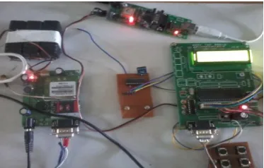
[image:4.595.308.496.100.247.2]In figure 4.1, 4.2 shows that the design, involves three major modules, firstly the blind person unit sends the request through the Bluetooth to the bus stop unit, and subsequently the bus stop unit gets information through the satellite using the GPS from the bus driver unit, finally the blind person takes the correct bus parked in front of him using a two way voice conversation.The special user groups gives the input about the place through the microphone used for receiving the commandand GPS used to transmit the latitudes and longitudes of the precise location of the bus.
[image:4.595.36.223.623.742.2]FIGURE 4.1 CONNECTION OF THE MODULE
FIGURE 4.2 OUTPUT DISPLAY
Similarly, in the architecture diagram of module shows the process of the hardware operations.
5.
CONCLUSION
Primarily, the blind person in the bus station is identified with RF communication. The blind informs the location he needs through the microphone which is given to the voice recognition system which produces the output of bus numbers in the voice synthesizer unit which is heard in headset. Then this location is transmitted to the transceiver in the bus. If the names in the transceiver in the bus matches with that of the name send by the blind, then there is an alarm in the bus unit alerting the presence of blind and a voice to the user's headset that the particular bus has arrived. With the help of GPS tracker connected with audio output the destination chosen by the blind is intimated when the bus reaches the correct location. PDA's can be used for GPS tracking but it is not cost effective.
6. REFERENCE
[1]P Verma, JS Bhatia,”Design and development of Gps-Gsm based tracking system with google map based monitoring”, International Journal of Computer engineering Vol 3, No. 3 and application, June 2013.
[2]Arjun Sharma, Rahul Patidar , ShubhamMandovara , IshwarRathod,” “Blind Audio Guidance System” (Blind Navigation)”, International Journal of Emerging Technology and Advanced Engineering, Vol 3, No. 2, Jan 2013.
[3] Abidkhan , Ravi Mishra,” GPS – GSM Based Tracking System”, International Journal of Engineering Trends and Technology,Vol 3,No 2,2012.
© 2016, IRJET | Impact Factor value: 4.45 | ISO 9001:2008 Certified Journal | Page 2281
[5] RishabhGulati,” GPS Based Voice Alert System for theBlind”, International Journal of Scientific & Engineering Research, Vol 2, No. 1, Jan 2011.
[6]P.Baranski,M. Moranski, Strumillo,Materka,” Remote guidance for the blind — A proposed teleassistance system and navigation trials”, 2008.
[7]Fleischer, P.B.; Nelson, A.Y.; Sowah, R.A.; Bremang, A., "Design and development of GPS/GSM based vehicle tracking and alert system for commercial inter-city buses," Adaptive Science & Technology (ICAST), 2012 IEEE 4th International Conference on , vol., no., pp.1,6, 25-27 Oct. 2012.
[8] Abed khan M.E.(Student), , Ravi Mishra, “GPS – GSM Based Tracking System” SSCET, CSVTU, Bhilai, India International Journal of Engineering Trends and Technology- vol.3,no.,pp,161-164, 2012.
[9] El-Medany,W.;Al-Omary,A.;Al-Hakim,R.;Al-Irhayim, S.;Nusaif, M.,"A Cost Effective Real-Time Tracking System Prototype Using Integrated GPS/GPRS Module," Wireless and Mobile Communications (ICWMC), 2010 6th International Conference on,vol.,no.,pp.521,525,20-25 Sept.2010.
[10]Hu Jian-ming; Li Jie; Li Guang-Hui, "Automobile Anti-theft System Based on GSM and GPS Module," Intelligent Networks and Intelligent Systems (ICINIS), 2012 Fifth International Conference on , vol., no., pp.199,201, 1-3 Nov. 2012.
[11] AkintundeMusibauAjagbe , Stephen EnyinnayaEluwa, Edward Eric Duncan, MohdKhairuddin Bin Ramliy, Choi Sang Long, and MkomangeClaudWantrudis, "The Use of Global System of Mobile Communication (GSM) Among University Students in Malaysia", International Journal of Innovation, Management and Technology, vol. 2, no. 6, pp. 547-588,Malaysia, Dec. 2011.
[12] Junaid Ali, ShaibNasim, Taha Ali, Naveed Ahmed and syedRiazunNabi, "Implementation of GSM based Commercial Automobile Tracker Using PIC 18F452 and Development of Google Earth Embedded Monitoring Software". IEEE International Conference on Research and Development, UPM Serdang, Malaysia, 16-18 Nov.2009.