© 2016, IRJET | Impact Factor value: 4.45 | ISO 9001:2008 Certified Journal | Page 2699
SmartCity(Karad) Android Application
Prashant Ghadage
, Sagar Yadav, Swarel Jadhav, Truptej Patil
Professor. Shinde R.S., Dept. Of Computer Science & Engineering, DACOE Karad, Maharashtra, India country
---***---Abstract -
Information Technology has become vital and integral part of every modern society. The rapid proliferation of mobile computing technology has massive potential for providing access to different services at any time and from anywhere. It allows accessing several applications and services via the internet connection or by building standalone applications. Android apps are helping peoples to make daily life activities easier. Nowadays, every individual has their own android device. Although there hasn’t any mobile application for information about overall activities in the city and Google map has their own limitations. The application like SmartCity(Karad) can inform citizens about key aspects of the city, to take initiative to social activities and to keep them updated. Also can bring peoples together to solve basic problems collectively. It can promote ideas like Smart City and Digital India and also can be effectively used for betterment of the society. When societies know more about the development in a technology, they become able to take advantage of it. When an innovation achieves a certain points after it has been presented and promoted, this technology becomes part of the society.Key Words: Proliferation, Digital, Technology, City, Integral, Modern society
1.INTRODUCTION
Cities have quite an impact in the economic development of a country, being the “platform” where many people live and work, where services are provided to citizens in a wide range of ways, and where local government officials have a close contact with citizens. It is only natural then that Information and Communication Technologies plays an increasing role in the life of both people and private and public entities that are part of a city.
Mobile apps are becoming a new frontline for city services, smartphone apps can centralize the point of contact for city resident and encourage collaboration in services in city. The spread of smartphones – cellphones with high-speed internet access and geolocation technology is transforming urban life. While many smart phones apps are largely about convenience such as apps that tell people when the next bus is coming or identify nearest restaurant.
City app can improve quality of life of citizens’ city apps should provide services which helps them in their daily life. Services which allow them to find locations, browse information about public private bodies, to share information among citizens. This city app can support social activities in city and to bring some basic problems in light. Citizens can easily access the information about private bodies such as theaters for current movie on screen, colleges for their events, hospitals for their schedules and kinds of treatments they providing to patients. Also, citizens can be informed about upcoming city events, banks for their locations and ATM’s , schedule of railways and buses. India has third largest users of the smart phones. All these introduced services can be implemented with Android app for establishing digital community in the city. This app can promote digital literacy among the citizens.
1.1 Project Idea
Project will come with android app which includes information about fundamental services in the city. This app will communicate with server with the help of internet to update information automatically. The citizens can access information in one touch in their android device. Also, citizens can use location services in the city with the help of offline map in app. To make governance transparent and responsible.
Since the use of Google Map to browse location within city does not enables peoples to do same, without internet connectivity. There does not exist solution including Google map technology to make consistent update in some important areas. A need exists where responsibility of content will be owned by respective personals and bodies. There is no mobile or web application that can establish fundamental information services within city.
1.2Need of Project
© 2016, IRJET | Impact Factor value: 4.45 | ISO 9001:2008 Certified Journal | Page 2700 where peoples can find their location in city.
Additionally they can browse locations of colleges, government offices and all other locations with the help of map. They can also find their route with the help of Google Maps. These locations are created and updated on map by individuals who have Google account. But it also raises question on reliability of content.
Fundamental information services about public and private organizations can only known to peoples by visiting them personally, newspapers and through advertisement. To solve and bring society’s problems in light peoples raise campaign with respective subject. Important events in the city are promoted and advertised with the help of newspapers and posters in the city, and get published by announcing it orally.To browse through city internet connectivity required. Cannot be accessed this services without internet. Content of locations could not be controlled efficiently. Updates not possible and data become invalidate with time. Reliability becomes low because of ownership of content is with unknown individuals or bodies.
Information about fundamental services of public and private organizations cannot be gathered effectively. Not only hard work is required but also time wasted, and updates to their content not possible with time.
1.3 Literature Survey
1. Smart Inclusive Cities: How new apps, big
data, and collaborative technologies are transforming immigrant integration.
Author : Meghan Benton Summery:
Smartphones-mobile phones that provide internet access and connect users to applications (apps) that use the location of the phone to filter information- are most commonly thought of as a tool for convenience. But their potential to address social problems such as disaster response, public health, and public safety is attracting widespread attention. The corresponding opportunities for immigrant integration have not, thus far, been rigorously assessed. In theory, smarphones may offer an effective platform to engage hard-to-reach populations, since disadvantaged groups often use them to access the Internet instead of personal computers, and recent arrivals and temporary
residents frequently use cellphones to keep in touch with family members at home.
2. Smart Cities Applications and Requirements
: White Paper
Author: Luis M. Correia, IST/IT – Tech. Univ. Lisbon, Portugal [email protected]
Smart Cities gained importance as a means of making ICT enabled services and applications available to the citizens, companies and authorities that are part of a city’s system. It aims at increasing citizens’ quality of life, and improving the efficiency and quality of the services provided by governing entities and businesses. This perspective requires an integrated vision of a city and of its infrastructures, in all its components. A Smart City can be taken according to six characteristics: Economy, People, Governance, Mobility, Environment, and Living.
2. IMPLEMENTATION DETAILS
2.1 Database Implementation
Database of SmartCity Karad application is loaded from two sources, first source is internet and second source is database file. When a module require database from internet it provides URL for php script on web server. When this script responds to the request it returns an JSON array from server. After receiving JSON response server app parses JSON and retrieves required information and stores it into database. After storing information into database it displays database to user.
© 2016, IRJET | Impact Factor value: 4.45 | ISO 9001:2008 Certified Journal | Page 2701 When application performs first launch then
sequence of operations gets carried out in order to save database on user device. On first launch of app the database file will be copied onto users device. Second operation is decrypting file whenever necessary and using this database file temporary and after that deleting this file.
2.2 Implementing Offline Map
To implement offline map in android app requires tiles for apps which can be used to display and develop app. To create offline map the required tiles of app can be downloaded from server like Mapquest or MapNik. Once these tiles downloaded from server these tiles must be compressed in order to save memory of device as well as .APK file. Once these tiles get compressed all tiles get zipped and exported with application through asset folder. On first launch of android application this zip file will be copied on user device. Once copying of file completed the zip file began to extract all the tiles on user device. Now path to these tiles will be saved and used when user request for Offline map module. To use these tiles effectively with app an open source library called OSMDroid is used which helps to draw these tiles very effectively. This library keeps track of locations in the sense of longitude and latitude. To draw overlay items like icons and text elements on map this library provides functions and procedure to display and draw it on map.
2.3 Implementing Network Interface
Android application requires dynamic information which can be updated periodically with the help of internet. To maintain information which can be downloaded into app requires having application and database server running on internet. Once the servers get setup, the address of server can be hardcoded into android application. To access internet from android application, application require two special permissions from android OS, first permission is access NETWORK_STATE and second permission is access INTERNET. When data exchange between server and android application is needed then special data format required which can handle this data in well
form. To exchange data in android application and server JSON becomes very useful. The JSON is abbreviation for Javascript Object Notation. Special libraries included in programming languages which can be used to encode and parse JSON data. Java programming language has apache package for parsing JSON data very effectively. There are plenty of open source libraries which can be used to download and cache images on user device such as Picasso is open source library which can be used to download and cache images from server.
2.4 Implementing Bus Timetable
Bus timetable is very important service which can be provided to the user. Over 8 hundreds of buses daily visit bus stand. To manage these number buses very efficiently we require maintaining category of these buses. This buses can be categorized with the help of routes the travel on. If user require specific bus then search feature becomes very important to search bus by providing source and destination bus name.
2.5 Implementing multiple language settings
To manage multiple languages in same android app we can make this possible with the help of maintaining multiple resource string files in android application. When user selects for specific language then particular string file will be loaded into android application. There can be as many as languages in this android app but we have implemented two languages first is English and second is Marathi.
2.6 Modules and Their Functionalities
1.
Social2.
City Hospitals3.
Theatres4.
Government Offices5.
Bus Timetable6.
Banks7.
Colleges© 2016, IRJET | Impact Factor value: 4.45 | ISO 9001:2008 Certified Journal | Page 2702
Social:
Social module use developed for awareness in peoples with basic social problems such as Tree plantation, air pollution and water pollution and also encourages planting trees and saving environment. This module includes an image slider which displays images sequentially. These images describe an story about environment to the user.
City Hospitals:
The information regarding major hospitals in the city will be given in this module. There addresses, contact information and schedule related
information will posted in this module.
Theaters:
The information regarding movie on theater screen will be displayed here and there schedule will posted in this module. Information will get updated weekly when there is new movie on screen get updated with the help of server.
Government Offices:
This module will help users to know
information about Government Offices. Information like office contact information, addresses, there location on map will be posted here.
Bus Timetable:
This module will help to users to know bus timetable where users have to specify source and destination names of buses. Also, users can view all buses without searching them.
Banks:
This module will help users to know
information about Banks in the city. Information like Bank contact information, addresses, there location on map will be posted here.
Colleges:
Information regarding colleges in the city will be displayed here. Where users can browse for college information like contact, addresses and college deparments.
Offline Map:
The offline map will be provided to users where users do not need to have active internet connection. This map can be updated for locations manually.
Train Timetable
Train timetable module displays train time in two categories. First category displays trains and their time with the help of direction trains travels.
© 2016, IRJET | Impact Factor value: 4.45 | ISO 9001:2008 Certified Journal | Page 2703
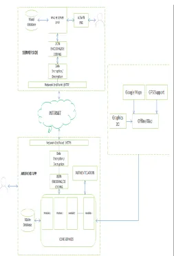
Fig -1: Overall Architecture
3. CONCLUSIONS
The concept of Smart Cities gained importance in the last years, as a means of making services and applications available to the citizens, companies and authorities that are part of a city’s system This perspective requires an integrated vision of a city and of its infrastructures, in all its components: it has to incorporate a number of dimensions that are not related to technology, e.g., the social and political ones. A Smart City can be taken according to six characteristics: Smart Economy, Smart People, Smart Governance, Smart Mobility, Smart Environment and Smart Living. The complete android app which will provide information services to the citizens. System will keep update to the citizens with information they need.
ACKNOWLEDGEMENT
It is our privilege to acknowledge with deep sense of gratitude to our project guide Prof. Shinde R.S. and our H.O.D Prof. Birnale M. A. whose supervision, inspiration and valuable discussion has helped us tremendously to complete our project. Their
guidance proved to be the most valuable to overcome all the hurdles in the fulfillment of this mega project on “SmartCity(Karad) Android Application”.
We are grateful to Principal Dr. Jalindar R. Patil for direct or indirect help in the completion of this project. Last but not least, this acknowledgement would be incomplete without rendering my sincere gratitude to all those who have helped us in the completion of this project.
REFERENCES
1.
White paper smart city application and Requirement.Published date - 2011-05-20
Chair: Luis M. Correia, IST/IT – Tech. Univ. Lisbon, Portugal
Co-Chair: Klaus Wünstel, Alcatel-Lucent – Bell Labs, Germany
2.
Smart Inclusive Cities: How New Apps, Big Data, and Collaborative technologies are transforming immigrant integration.Author: Meghan Benton
Published year: September 2014