University of Michigan
2017
The Catalytic Escalators of Hong Kong
Szatko, Liz
Szatko, Liz (2017). "The Catalytic Escalators of Hong Kong," Agora, 68-74.
http://hdl.handle.net/2027.42/136591
H
ong Kong is a Special Administrative Region on the coast of southeast Asia, covering a land area of 427 square miles stretching from mainland China to several small islands to the southeast.1 Among its land holdingsis Hong Kong Island, a mountainous area covered with lava rock, steep mountainsides, and thick vegetation. Claimed as a British colony in 1841, the area between the island and mainland was soon established as an active trading port, as well as a safe haven from the rebellions and natural disasters in southern China.2 As a result,
The Central Mid-Level Escalators in Hong Kong’s Central and Western Neighborhoods are the result of a highly dense urban fabric, a population that needs to move throughout the city, and topography that makes this movement difficult. The escalators facilitate the continuous and fluid movement of people through a city that has become a rich and vibrant urban metropolis. The resulting escalator corridor has provided unique connections and enlivened the urban environment at multiple levels, creating a street that flows in and out of Hong Kong’s buildings. The diverse building makeups, parks that provide small moments of relief, and the ocean and forest as visual breaks further allow for an increased density while also providing a diverse and exciting urban context. This case study and accompanying illustrations show a few of the diverse moments along the path, and some of the lessons that can be learned from this successful infrastructural intervention.
The Catalytic Escalators of
Hong Kong
Liz Szatko
Master of Architecture 2017
a large population developed on the island. However, due to the island’s terrain, soil, and landforms, only a small percentage of its land area was suitable for building. This resulted in Hong Kong becoming one of the most densely populated metropolises in the world. A challenge of designing Hong Kong’s infrastructure was responding to the region’s geographical limitations and the demands of its population growth. This resulted in a variety of unique solutions, one of which was the Central Mid-Level Escalators.
Constructed in 1993 by Hong Kong, the path of 20 escalators navigates Hong Kong’s steep terrain in the island’s Central and Western neighborhoods, providing free access for the neighborhoods’ residents between commercial, business, and residential districts.3 It is the longest
outdoor covered escalator system in the world, spanning nearly a mile in length. It connects to the elevated walkways that run throughout many other Hong Kong neighborhoods. These connections facilitate pedestrian movement in three dimensions through a dense urban environment. During the hours from midnight to 10:00 a.m., the escalators run downhill, allowing the residents to move down the mountain towards the commercial and business districts Liz Szatko is a student in the Master of Architecture program at the University of Michigan. She completed her undergraduate
Liz Szatko
along the island’s waterfront. In the afternoon and evening hours the escalators run uphill, providing continuous movement up the base of the mountain back to the residential Mid-Level neighborhood.
Each day the elevators serve roughly 85,000 people4 at a rate of about 120 people per
escalator per minute.5 Alongside the escalators
there are paths for pedestrians traveling in the
[image:3.540.81.460.78.431.2]opposite direction of movement, as well as a ground-level walking corridor lined by shops and restaurants. The escalators’ landings meet this ground path at every intersection, allowing commuters to easily enter or exit. The system creates constant pedestrian traffic, which has led to the development of a rich commercial strip along the escalators resulting in concentrated bustling districts. The restaurants and storefronts are active throughout the length of the escalators in commercial, business, and residential
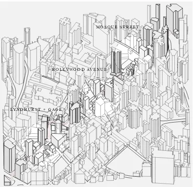
Figure 1 Map of Hong Kong.
H O N G KO N G I S L A N D N E W T E R R I T O R I E S
L A N TA U I S L A N D
KO W L O O N
C H I N A
M I R S B AY
buildings, as shown in the illustrations of a few intersections along the path. Closer to the base of the mountain, the Lyndhurst and Gage intersection is home to office and commercial buildings, and it is more active during daytime hours. Near the Hollywood Street intersection, the SOHO (South Hollywood) district is filled with restaurants, small shops, and larger retail. Toward the top of the escalators’ path is Mosque Street, a primarily residential area within the Mid-Level neighborhood. The escalators allow
for more rapid pedestrian movement than could be achieved by simply walking, reducing pedestrian congestion that is characteristic of large metropolises, and allowing for more fluid movement throughout the districts.6 In this way,
the escalators, winding through a large number of Hong Kong neighborhoods, facilitate density.
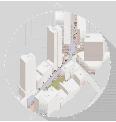
[image:4.540.74.469.69.452.2]The city manages to create urban conditions that successfully foster areas of high density while Figure 2 T he escalators’ path.
L Y N D H U R S T + G A G E
H O L L Y W O O D AV E N U E
Liz Szatko
utilizing strategies that work as antitheses of both traditional and neo-urbanistic tactics. In many instances there is disregard for the necessity to provide large amounts of daylighting deep into dwelling units,7 and buildings do not adhere to
stepped back building facade requirements.8
Hong Kong’s development called for rapid growth in a small area for a large population.
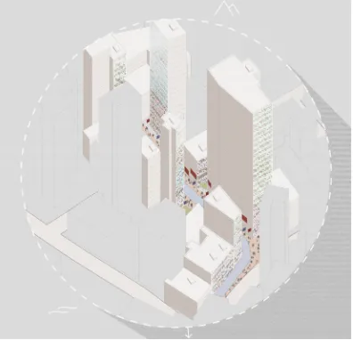
[image:5.540.74.468.189.603.2]This led to the division of the city into small lot sizes which, when higher density was desired, resulted in tall, slender buildings. However, not all buildings reach the heights of “skyscraper, and the resulting fabric is a vibrant and ever-changing streetscape for the city. The dense network of buildings in these neighborhoods is not overwhelming in a perceived experiential
sense, even though some blocks can reach floor area ratio (FAR) values much higher than those of other large metropolises. This diversity of building type, along with relief from the built condition in the form of parks and vistas to the mountain forest above and water below, creates a unique urban environment.
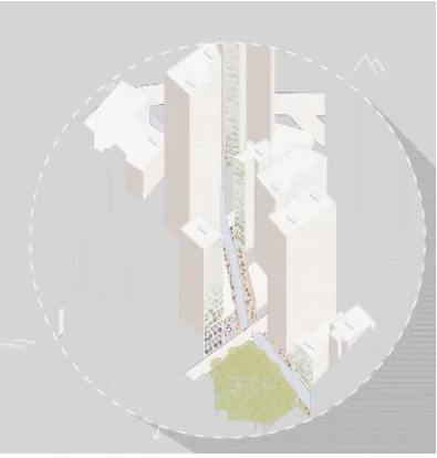
The escalators and the region’s dense population are mutually dependent. Without a large
[image:6.540.74.470.219.601.2]population, the escalators may not have been necessary infrastructure for the city, and without the escalators, the pedestrians would not have means to easily navigate the terrain, resulting in small, separated communities that would not promote the city’s growth. The escalators also work as a clearly visible means of transportation and provide a visual mark of how to navigate the city. While the escalators have a prominent role in maintaining the infrastructure of Hong Kong’s Central and Western neighborhoods, one can
Liz Szatko
also attribute their success to their ability to help residents and visitors navigate the city.
Hong Kong made a conscious effort to create infrastructure that supports and encourages pedestrian movement. The large populations that navigated the slopes by both vehicle and foot traffic were beginning to conflict in the
[image:7.540.74.469.71.485.2]late 1980s as traffic increased in the Mid-Level neighborhood. With the implementation of the escalators, pedestrians were able to move more quickly in a separate environment than that of the vehicle. This encouraged walkability through the districts by minimizing congestion and expediting commutes for both vehicles and pedestrians.
While the escalators’ path runs from the more residential Mid-Level neighborhood to the commercial and business districts of the waterfront, it is important to note that the success of the escalators is not merely that they connect point A to point B. The escalators have encouraged the growth of multiple intermediary districts and neighborhoods, and have fostered development throughout their path. They have become a destination point for residents and tourists alike. The infrastructure has gone beyond a utilitarian purpose or solution and has become a major catalyst for the success of the district.
The escalators are successful for the specific design needs and conditions of Hong Kong, but there are a few factors that should be considered before implementing similar solutions in other metropolises. First, focusing on pedestrian-oriented transportation infrastructure is an important component of the future of cities. A focus on short rapid foot traffic is a positive asset in a city or district as densely populated as Hong Kong in order to mitigate congestion that
results from vehicular traffic and pedestrian traffic interacting.
Furthermore, it is important to note that the escalators also solve the problem of negotiating the terrain of a steep mountainside that would otherwise have to be traversed through narrow, winding streets. San Francisco, California is an example of a city that might consider escalators because geography determines how people navigate the city. However, in this instance the escalators would still need to be confined to a small area where the population is dense enough to support the use and keep the escalators active through non-peak commute hours. The most important factor to consider, however, is that one cannot attribute the escalators’ success to the infrastructure alone, but also to the districts surrounding them and the districts they connect while encouraging walkability. These districts encourage the escalators’ success, and in turn, the escalators encourage the growth and continued use of the districts.
Endnotes
1. Encyclopædia Britannica (Encyclopædia Britannica, 2016), s.v “Hong Kong | history - geography - administrative region, China” by Chi-Keung Leung, accessed March 27, 2016, https://www.britannica.com/place/Hong-Kong. 2. John M. Carroll, A Concise History of Hong Kong (New York: Rowman & Littlefield Publishers, 2007).
3. Sharon Cullinane “The Relationship Between Car Ownership and Public Transport Provision: A Case Study of Hong Kong.” Transport Policy 9 no. 1 (January 2002): 29-39. http://www.sciencedirect.com/science/article/pii/ S0967070X01000282.
4. “LCQ10: Hillside Escalator Links and Elevator Systems,” December 16, 2015, accessed January 15, 2017, http://www. info.gov.hk/gia/general/201512/16/P201512160340.htm.
5. William H. K. Lam and Chung-yu Cheung, “Pedestrian Speed/Flow Relationships for Walking Facilities in Hong Kong,” Journal of Transportation Engineering 126 no. 4 (July 2000), doi:10.1061/(asce)0733-947x(2000)126:4(343).
6. Ibid.
7. Work of Rudy Uytenhaak.