14th International Conference on Wireless Communications, Networking and Mobile Computing (WiCOM 2018) ISBN: 978-1-60595-578-0
The Model Research on Location Fusion Algorithm with Big Data
Selection and Accuracy Correction
Yini Zhang1, Ping Zhao1, Yuanwei Zhao2, Zhongjiang Yan1 and Bo Li1
ABSTRACT
As the requirements of smart, reliable and precise location for a vehicle, the model of fusion location algorithm with big data selection and accuracy correction is established to achieve reliable and low-cost fusion location. In this paper, the data of simple inertial navigation and the data of various positioning system sources with different errors are intelligently selected, and Kalman filtering is used to fuse the location information by the function of algorithm model, and the four kinds of location information of GPS, SINS, DR and TDOA are chosen to simulate fusion algorithm. The simulation results in MATLAB environment show that the proposed fusion location algorithm model is efficient to improve the accuracy and reliability of the location algorithm.
Keywords: Combined Location; Fusion Algorithm Model; Big Data Selection; Kalman Filtering
1. INTRODUCTION
For so many kinds of location methods, it is difficult to get reliable position with only one positioning method. So combined location is becoming more and more common in applications, which also provides a good way to make use of all kind of positioning sources with big data platform.
In terms of the moving objects positioning, reference [1] proposed a federated filtering algorithm based on adaptive Kalman filtering. Reference [2] designed a fault-tolerant federated filtering algorithm for the combined positioning system to ensure the accuracy of the system when the GPS information was interrupted. Reference [3] designed a Sage-Husa Kalman filter based on UD decomposition for the divergence phenomenon of conventional filters. Reference [4] proposed a method to integrate different sensors to correct the inertial velocity for the hybrid positioning of urban vehicles. In terms of big data fusion, reference [5] proposed the optimization of dynamic data from different data sources and proposes the big data fusion based on dynamic feature selection from different data sources. Reference [6] presented a novel technique by using a hybrid algorithm for clustering and cluster member selection in the wireless multi-sensor system.
2. ALGORITHM MODEL OVERALL DESIGN
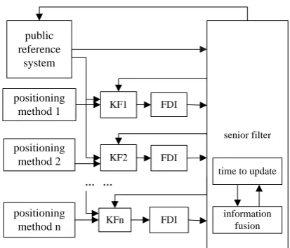
Kalman filtering is often used to fuse different positioning information. There are two common combinations: centralized Kalman filtering and distributed Kalman filtering. Compared with centralized filtering with poor fault tolerance, distributed filtering has the advantages of low computational complexity and high fault tolerance, and is widely used in positioning systems. Federal filter is a kind of common distributed Kalman filter and the structure as shown in the Figure 1[7].
In federal filtering, a high-reliability system is selected as the public reference system firstly, and the remaining systems are combined with the public reference system to form the subsystems which perform information optimization filtering and send the obtained information to the main filter for data fusion.
Combining different positioning methods, the optimal selection fusion localization algorithm based on big data fusion is established. Select a system with small external influence as the public reference system and define it as α. Then build subsystems and perform Kalman filtering. The filtered subsystems carry out credibility detection, which specifically includes fault detection and positioning deviation detection of the subsystems. Fault detection is used to detect the extent to which subsystems are affected by noise, and positioning deviation detection is used to detect whether the positioning values obtained by these methods are suitable for positioning judgment. Select a positioning deviation range∆r , if the fault-free subsystem positioning deviation satisfies:
K𝐹𝑖 − α ≤ ∆r(1)
trust this subsystem. Untrusted subsystems are quarantined and error detection is performed on trusted subsystems. If the error of the positioning method is less than public reference system:
𝐸𝑟𝑟𝑀𝑖 < 𝐸𝑟𝑟𝛼(2)
public reference
system
positioning method 1
positioning method 2
positioning method n
KF1
KF2
KFn
FDI
FDI
FDI
… …
senior filter
time to update
[image:3.612.202.409.76.253.2]information fusion
Figure 1. The structure of federal Kalman filter.
N Y
N
Y N
Y
multiple positioning source information acquisition
select public reference system
build subsystems ,filterKF KF1, 2,...,KFn
source subsystems credibility detectiom
isolate unstrusted subsystems
the number of trusted
subsystems=0? α
sort positioning methods by accuracy,
(k is the number of trusted subsystems)M1,M2,...,Mk
define the corresponding subsystems as S1,S2, ...,Sk
i=1
position error detectioni M
error within the seting?Mi
i<k?
i
M
i=i+1
information fusionS S1, 2,...,Sk
output optimized positioning information
adding auxiliary positioning information such as images
output optimized positioning information
[image:3.612.189.410.293.638.2]3. SYSTEM MODEL ESTABLISHMENT
The public reference system is combined with remaining positioning systems to construct subsystems, and establish the corresponding state equations and measurement equations. Kalman filtering is performed on each subsystem to obtain optimal state of the subsystem.
In this design, four different positioning methods are chosen to form a combined positioning system. Selecting SINS which is not dependent on external information as the public reference system. GPS/SINS is subsystem1, DR/SINS is subsystem2, TDOA/SINS is subsystem3.The system state error is selected as the state variable to establish the state equation. Geographic coordinate system is selected as navigation coordinate system. X-axis points to the east, y-axis points to the north, and z-axis points to the sky. In carrier coordinate system, x-axis points to the right, y-axis points to the front, and z-axis points to the top.
A. GPS/SINS
SINS state error includes: attitude error𝜑𝐸, 𝜑𝑁, 𝜑𝑈, speed errorδ𝑉𝐸, δ𝑉𝑁, δ𝑉𝑈, position errorδE, δλ, δH, gyro drift𝜀𝐸, 𝜀𝑁, 𝜀𝑈,accelerometer deviation∇𝐸, ∇𝑁, ∇𝑈,GPS status error includes: speed errorδ𝑉𝐺𝐸, δ𝑉𝐺𝑁, δ𝑉𝐺𝑈 ,position errorδ𝐸𝐺, δ𝜆𝐺, δ𝐻𝐺.
State vector:
𝑋1 = (𝜑𝐸, 𝜑𝑁, 𝜑𝑈, δ𝑉𝐸, δ𝑉𝑁, δ𝑉𝑈, δE, δλ, δH, 𝜀𝐸, 𝜀𝑁, 𝜀𝑈, ∇𝐸, ∇𝑁, ∇𝑈, δ𝑉𝐺𝐸, δ𝑉𝐺𝑁, δ𝑉𝐺𝑈, δ𝐸𝐺, δ𝜆𝐺, δ𝐻𝐺)𝑇
(3)
State equation:
𝑋̇1 = 𝐹1𝑋1+ 𝑊1(4)
State transformation matrix:
𝐹1 = [𝐹𝑆𝐼𝑁𝑆0 𝐹0 𝐺𝑃𝑆](5)
𝐹𝑆𝐼𝑁𝑆isSINS state transformation matrix,𝐹𝐺𝑃𝑆is GPS state transformation matrix.
SINS and GPS speed measurement differences and position measurement differences are selected as the measurement equation:
𝑍1 = [𝑉𝑃𝑆𝐼𝑁𝑆− 𝑉𝐺𝑃𝑆
𝑆𝐼𝑁𝑆− 𝑃𝐺𝑃𝑆] = 𝐻1𝑋1+ 𝑉1(6)
Measurement matrix:
𝐻1 = [003×3 𝐼3×3 03×3 3×3 03×3 𝐼3×3
03×6 −𝐼3×3 03×3
B. DR/SINS
The SINS state variables are selected the same as subsystem1, DR state variables select position error δ𝐸𝐷, δ𝜆𝐷, δ𝐻𝐷 and odometer scale factor errorδ𝐾𝐷 [8].
State vector:
𝑋2 = (𝜑𝐸, 𝜑𝑁, 𝜑𝑈, δ𝑉𝐸, δ𝑉𝑁, δ𝑉𝑈, δE, δλ, δH, 𝜀𝐸, 𝜀𝑁, 𝜀𝑈, ∇𝐸, ∇𝑁, ∇𝑈, δ𝐸𝐷, δ𝜆𝐷, δ𝐻𝐷, δ𝐾𝐷)𝑇(8)
State equation:
𝑋̇2 = 𝐹2𝑋2+ 𝑊2(9)
is the combination of state transition matrix for SINS and DR.
Select SINS and DR position measurement differences as the measurement equation :
𝑍2 = [𝑃𝑆𝐼𝑁𝑆− 𝑃𝐷𝑅] = 𝐻2𝑋2+ 𝑉2(10)
Measurement matrix:
𝐻2 = [03×6 𝐼3×3 03×6−𝐼3×3 03×1](11)
C. TDOA/SINS
The state error of SINS is selected as the state vector𝑋3[9].
State equation:
𝑋̇3 = 𝐹3𝑋3+ 𝑊3(12)
State transformation matrix:
𝐹3 = 𝐹𝑆𝐼𝑁𝑆(13)
The measurement equation selects SINS and TDOA position measurement differences:
𝑍3 = [𝑃𝑆𝐼𝑁𝑆− 𝑃𝑇𝐷𝑂𝐴] = 𝐻3𝑋3+ 𝑉3(14)
Measurement matrix:
𝐻3 = [03×6 𝐼3×3 03×6](15) 2
4. SYSTEM DETECTION AND RECONSTRUCTION
System detection includes the credibility detection which involves fault detection and positioning deviation detection of each subsystem, and the error detection of positioning methods.
An important feature of the combined positioning system is fault tolerance, which is reflected in fault detection and reconstruction[10]. The system has self-monitoring capability, it can monitor operating status in real time and detect faults to reconfigure the system. Fault detection using Chi-square test. Based on the status of subsystems, the fault detection function is established[11][12]. Judging whether the subsystem is faulty according to the fault detection result, and positioning deviation detection using (1) as a criterion.
Appropriate reference errors is used to determine which subsystems are selected for information fusion. The model of optimal selection fusion location algorithm proposed in this paper, positioning error of the public reference system is selected as reference error. The fused information is still selected in the case where the positioning method error is smaller than public reference system positioning error, the final positioning effect cannot be optimal. System reconstruction based on the test results.
Y N Y N Y N N Y N Y N N N Y Y N Y N Y
input filtered subsystems positioning information
credibility detection
isolate untrusted subsystems
define m as the number of trusted subsystems
m=0? SINS
m=1?
define the trusted subsystem number as k
?
Mk SINS
Err Err
k M k KF m=2? define the trusted subsystem number as i,j(i<j) ? Mi SINS
Err Err
?
Mj SINS
Err Err Mj
information fusionKF KFi, j
?
GPS SINS
Err Err
GPS ?
DR SINS Err Err
DR
?
TDOA SINS
Err Err
TDOA
information fusion
1, 2, 3
KF KF KF
output optimized positioning information
[image:6.612.198.417.330.642.2]i M
Figure 3. Simulation system detection and reconstruction.
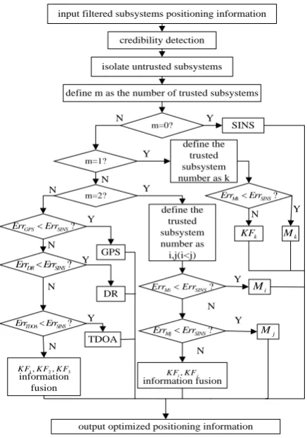
to make full use of positioning information to obtain relatively accurate positioning results, credibility detection of subsystems and error detection of trusted subsystems are required before information fusion. The credibility test is used to detect three subsystems, and the error detection mainly detects the GPS positioning error under the premise of subsystem 1 being reliable.
Subsystem 1 is isolated when it is not trusted and SINS positioning information is output when all subsystems are not trusted.
If GPS positioning can be used for system positioning judgment, it is divided into two cases: One is that GPS positioning error is very small and can be considered as an ideal state, positioning information fusion will reduce the system accuracy. Therefore, the GPS positioning information is directly used as the final positioning result. Second, subsystem 1 is reliable but the GPS positioning error is large. In this case, the specific location information screening and fusion is performed on the premise of reliably detecting the other two subsystems. Since the subsystem filtering is a correction to the SINS positioning information, the determination of whether the GPS positioning information can be used directly is based on the SINS positioning error. If GPS positioning error is smaller than SINS positioning error, that is, if the (2) is satisfied, it is the first case, otherwise it is the second case. Similarly, the above method is used to judge the use of data in the other two subsystems.
5. ALGORITHM SIMULATION
The simulation was performed in MATLAB R2017a environment and the first-order optimization of the algorithm was simulated. The initial conditions for the simulation are set to: Gyro constant drift0.01 ° ℎ⁄ , gyro angle walk coefficient0.001 ° √ℎ⁄ , accelerometer drift
N
Y system intialization
set the simulation time and filter period
get real track
SINS attitude solution
subsystems matrix calculation
discretization
Kalman filtering
fault detection
positioning deviation detection
screening subsystems
error detection
filter location information
information fusion
store optimized positioning data
t=1100s?
[image:8.612.213.385.71.319.2]output positioning trajectory and error
Figure 4. Simulation algorithm block diagram.
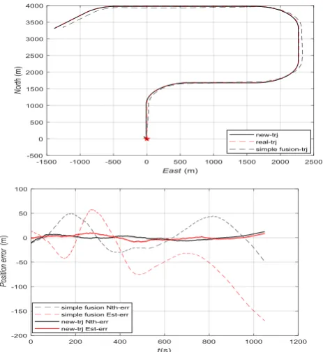
[image:8.612.190.422.368.621.2]Figure 5 shows the positioning trajectory and positioning error in two different ways of simple fusion positioning and selective fusion positioning under the premise of ideal GPS positioning. In the trajectory map, it can be seen that selects the GPS positioning trajectory as the final positioning result substantially coincides with the real trajectory. From the error chart, we can see that the positioning error obtained by the optimal selection fusion location algorithm is within±20m, simple fusion positioning error reaches±150m.
Figure 6 shows the positioning trajectories and errors when both GPS and TDOA are disturbed. Error chart shows that the optimal selection fusion location algorithm locates errors within±100m, simple fusion positioning error reaches±250m. When subsystem 1 is reliable but GPS positioning is disturbed, if TDOA is also interfered, the positioning error will increase unnecessarily when using simple information fusion. Instead, selective fusion of positioning data can significantly improve the positioning results.
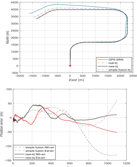
When GPS is subjected to strong interference during positioning, it can be seen from the GPS-SINS positioning trajectory in figure 7 that GPS positioning is not suitable for final positioning. If the information fusion of the main filter is performed directly, although the final positioning result is better than the positioning result of the subsystem 1, there is still a certain degree of error. The positioning error obtained by the optimal selection fusion location algorithm is within±50m, simple fusion positioning error reaches±150m . With the optimal selection fusion location algorithm, it can be seen that both the positioning trajectory and the positioning error are improved.
6. CONCLUSIONS
To obtain the best location information in the big data environment, choosing the appropriate location source information for integration is important. The reliability of different positioning sources are different, and sometimes, the final result will be unsatisfactory if the information fusion is performed blindly. An intelligent optimal selection fusion location algorithm which selects and fuses multiple positioning source information based on big data environment is proposed in this paper, the results obtained have improved positioning accuracy and reliability. First-level optimization simulation proves that positioning accuracy has been improved apparently.
ACKNOWLEDGMENT
This paper was supported in part by the National Natural Science Foundations of CHINA (Grant No. 61771390, No. 61501373, No. 61771392, and No. 61271279), the National Science and Technology Major Project (Grant No.2016ZX03001018-004).
REFERENCES
1. Yuan, D., Ma, X., Liu, Y., Yang, L., Wu, Y., & Zhang, X. 2017. “Research on underwater integrated navigation system based on SINS/DVL/magnetometer/depth-sensor”. Oceans (pp.1-6). IEEE.
3. Liu, J., Chen, H., & Liu, N. 2017. “Effective Sage-Husa Kalman filter for SINS/Doppler/Platform Compass integrated navigation system”. Guidance, Navigation and Control Conference (pp. 541-546). IEEE.
4. Lim, J. H., Choi, K. H., Kim, L. W., & Lee, H. K. 2016. “Land vehicle positioning in urban area by integrated GPS/BeiDou/OBD-II/MEMS IMU”. IEEE International Conference on Intelligent Transportation Engineering. IEEE.
5. Aboud, A., Fdhila, R., & Alimi, A. M. 2017. “MOPSO for dynamic feature selection problem based big data fusion”. IEEE International Conference on Systems, Man, and Cybernetics. IEEE. pp. 003918-003923.
6. Din, S., Ahmad, A., Paul, A., Rathore, M. M. U., &Jeon, G. 2017. “A cluster-based data fusion technique to analyze big data in wireless multi-sensor system”. IEEE Access, 5(99), 5069-5083.
7. JiShitao, & Wan Yanhui., 2005. “Research on on-Board SINS/GPS/DR Integrated Navigation Filters”. Journal of Projectiles, Rockets, Missiles and Guidance, 25(1), 293-296.
8. Yan Gongmin, & Qin Yongyuan., 2005. “Research on Vehicle Laser Gyro SINS/DR Integrated Navigation System”. Journal of Projectiles, Rocket, Missiles and Guidance, 25(4), 20-23.
9. XuRui, Sun Yongrong, Liu Jianye, & Shen Xuesong., 2008. “Study on TDOA-DR Combined Vehicle Navigation and Positioning System”. Transducer and Microsystem Technologies, 27(4), 37-39.
10. Zhang Chongmeng, Zhuang Liangjie, Chen Chaoying, & Liu Fei.1999. “A Fault Tolerant Federated Filtering Algorithm for INS/GPS/Doppler Integrated Navigation Systems”. Journal of Chinese Inertial Technology (4), 2-6.
11. Peng Rong. 2003. “Research on Information Fusion and Fault Tolerance in Intelligent Integrated Navigation Systems”. (Doctoral dissertation, Northwestern Polytechnical University).