REVIEW ARTICLE
A SURVEY ON LOCATIONTRACKING SYSTEM IN ANDROID
*
Ms.Prajakta Pande and Amit Welekar
Department of CSE, Tulsiramji Gaikwad Patil College Engineering and Technology, Nagpur,India
ARTICLE INFO ABSTRACT
This paper reviews a number of applications designed for location tracking on mobile phones and also how this location tracking can help in a variety of ways. The Location tracking is one of the location based services. Location based services are set of services provided to a user based on his location. A location of a mobile can be found out either with the help of mobile network or by Global Positioning System (GPS). Most of the mobile phones these days are embedded with the hardware required to use this GPS technology and are also easily available. Android is a new generation of smart mobilephone platform launched by Google. Android supports GPS, Video Camera, compass, and 3d-accelerometer and provides rich APIs for map and location functions. Users can flexibly access, control and process the free Google map and implement location based mobile service in his mobile systems at low cost.
Copyright © 2014 Ms.Prajakta Pande and Amit Welekar. This is an open access article distributed under the Creative Commons Attribution License, which permits unrestricted use, distribution, and reproduction in any medium, provided the original work is properly cited.
INTRODUCTION
Applications that provide services to the users based on his location are widely being used these days. These applications range from social networking to navigation to banking, Consumers are being offered a variety of location-based services. LBS are rapidly expanding in both number and variety. They offer a wide range of services: navigation tools to help you to reach your destination , local search to help you find nearby businesses or events, friend finders and social networking , applications that allow you to check in at certain locations and applications that can link your location to other activities Many users currently access LBS through mobile phones, but location-aware devices such as laptop and desktop computers and in-car navigation and assistance systems can also be used to access many of these services. In mobile communication location tracking plays a major role using this location based services. In order to track the location of the user’s mobile device it checks the nearest base station available to the mobile network and Global Positioning System for tracking location. The GPS satellite is used for navigation purpose and it is combined with LBS is used to track the location of mobile device and the actual work of GPS is to calculate the position in the measure of coordinates like latitude and longitude values through the GPS receiver.
*Corresponding author:Ms. Prajakta Pande,
Department of CSE, Tulsiramji Gaikwad Patil College Engineering and Technology, Nagpur, India.
In general this GPS works in open space areas only and used for radio navigation purpose through radio signals the GPS is a small device that can be embedded in any devices like mobiles. The mobile that is embedded with GPS receiver calculates the exact longitude, latitude and altitude values and those values can be used by LBS for finding the location. GPS also provides information like time for calculating sender and receiver locations based on the information received from the satellites. Using GPS receiver in the mobile device we can even set the navigation path from source to reach a particular destination. Three satellites may be enough for computing the position of mobile devices.
Location based Services can be classified into following categories
Public Safety / Emergency Services
The location of the client can be determined by the mobile carrier hence it finds great use during Emergency since it can be used during the emergency/health hazard to locate the mobile clients.
Consumer Services
Now days, smart phones like (Android, Blackberry and iPhone) provide a set of location based applications and services which helps the users to access the multiple services based on the user location.
Maps Navigation- The users can use the Google Mapsto get
to the particular location or to trace the route between any two locations.
ISSN: 0975-833X
International Journal of Current Research
Vol. 6, Issue, 12, pp.10527-10531, December, 2014
INTERNATIONAL JOURNAL OF CURRENT RESEARCH
Article History:
Received 14th September, 2014 Received in revised form 06th October, 2014
Accepted 09th November, 2014
Published online 27th December,2014
Key words:
Location Based Services (LBS), Location Tracking,
Marketing/Advertising- Many corporate companiesadvertise their items based on the location of the clients. For Example – Sale in Shopping Mall near to your location.
Location based Reminders- The phones can be used toset as
the reminder based on the location. For e.g. - Setting the Location based Alarm while traveling in the train
Preferred Location Search- The user can also initiate the
search of any nearby ATM or Restaurant within 5/10/15 kms range from his current present location.
Location Tracking Systems
Location tracking refers to attaining of the current position of a object stationary or moving. Localization may occur either via multilateration of radio signals between (several) radio towers of the network and the phone, or simply via GPS. To locate the Source using multilateration of radio signals, it must emit at least the roaming signal to contact the next nearby antenna tower, but the process does not require an active call. GSM is based on the signal strength to nearby antenna masts. Mobile positioning, which includes location based service that discloses the actual coordinates of a mobile phone bearer, is a technology used by telecommunication companies to approximate the location of a mobile phone, and thereby also its user (bearer). The more properly applied term locating refers to the purpose rather than a positioning process.
The present-day location tracking and control system can be
classified according to the usage as follows (Anderson et al.,
2009):
Real Time Online
Offline
Semi-offline
The Real Time Online device receives the real time position from the satellite and relays the information to the server at all time.
The general online system is based on GPRS/EDGE/3G for the
information relayed to the server (Lee et al., 2008). This online
tracking is commonly used with operations requiring locations at all time, e.g., logistics system, traffic system, taxi system, etc. The advantages lie in convenience of use. Managing and control is also efficient owing to the server that functions as a monitor and controller. The Offline device also receives the present location from the satellite and records various data such as position, time, speed, etc. in its memory storage which is similar to the black box of an airplane. The information is not relayed to the user. The user has to check the recorded data when it is needed. Thus, there is no expense because the system is not connected to a network. The Semi-Offline receives the real time location from the satellite and sends it to the user as requested. Data sending can be based on GPRS/ EDGE/3G or in the form of SMS. The advantage of the SMS semi-offline is alleviation of GPRS/EDGE/3G expense. The Semi-Offline is thus commonly used in the tracking system at
present (Hameed et al., 2010). There are various types of
services that can be provided by tracking user’s location. Location tracking can be used in providing emergency services
to users (Ankita et al , 2014)If a disaster occurs and a person
who is registered on the application is trapped in some area, then he can immediately contact the rescue team, the rescue team can show him nearby safest place, and they can chat with him and the person can tell them his status, and using GPS they can reach to the person.
The family of the trapped person can also see his last known location if they are also registered on the application. People having this application can also see weather forecast. Also through this application registered people will be able to search for nearby hospitals. In GPS based accident reporting system
using android mobile phone (M.Jhansirani et al.,2014) a unique
[image:2.595.144.449.391.604.2]technique known as location-based delivery (LBD), which mixes SMS and GPS, is projected, and more, a practical system to perform precise location following is developed. LBD principally applies the subsequent 2 projected techniques:
Location prediction and dynamic threshold. Location prediction is performed by victimization the present location, moving speed, and bearing of the target to predict its next location.
Once the space between the anticipated location and also the actual location exceeds a precise threshold, the target transmits a brief message to the hunter to update its current location. The dynamic threshold maintains the placement following accuracy and range of short messages on the idea of the moving speed of the target.
Public transport networks (PTNs) are difficult to use when the user is unfamiliar with the area they are traveling to. In these situations, adequate on-trip navigation information can substantially ease the use of public transportation and be the driving factor in motivating travelers to prefer it over other modes of transportation. However, estimating the localization of a user is critical for providing relevant information. Relevant design issues for a modular cost-efficient user-friendly on-trip Navigation service that uses position sensors
are accessed (Pradip et al., 2014). By helping travelers move
from single-occupancy vehicles to public transportation systems, communities can reduce traffic congestion as well as its environmental impact. This will increase the satisfaction of current public transportation users and help motivate more people to ride.
In the tracking system developed by (Mahadevaiah et al.,
2014) the location tracking is used to find location of vehicle that has been stolen and using a remote some signals can be sent to inbuilt hardware within the system to automatically stop the car. Vehicle tracking and locking system is installed in the vehicle, to track the place and locking engine motor. The place of the vehicle is identified using Global Positioning System (GPS) and Global system mobile communication (GSM). These systems constantly watch a moving Vehicle and report the status on demand. When the theft is identified, the responsible person send SMS to the microcontroller, the microcontroller issue the control signals to stop the engine mot or. Authorized person need to send the password to controller to restart the vehicle. In the system proposed in Android
location based services(Nilima et al.,2014) the implementation
of location based services through Google Web Services and Walk Score Transit APIs on Android Phones to give multiple services to the user based on their location.
The Global Positioning System (GPS)
The Global Positioning System (GPS) uses a constellation of 24 satellites which are in orbit of the earth.GPS is a process that can be used to find position at any point on the globe.
It can be used to determine following values at any point on the earth.
One’s exact location (latitude, longitude, height).
The precise time (Universal time coordinated).
[image:3.595.310.559.51.214.2]The speed and direction of travel can be calculated from these coordinates and time.
Fig. 2. Finding latitude, longitude with GPS
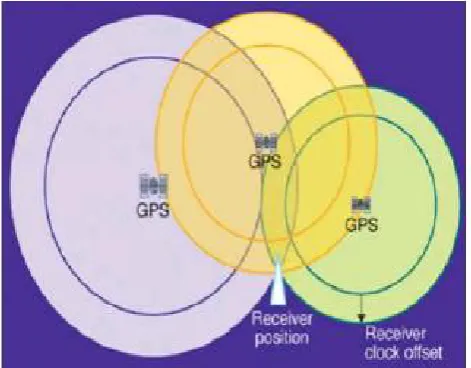
GPS receivers are used for positioning, locating, surveying and determining the time and are employed by both private individuals and companies. The GPS finds the user position by calculating differences in the times the signals, from different satellites, take to reach the receiver. GPS signals are decoded, so the smart phone must have in-built GPS receiver. In order to compute position, a GPS device listens for and locks on to at least 4 satellite signals. For civilian use, these signals are broadcast on the L1 (1575.42 MHz) frequency, and use a special modulation method to ensure that signals from various satellites do not interfere with each other even though they are on the same frequency .Each satellite broadcasts its specific absolute position as well as a carefully calibrated time signal. All satellites in the constellation continually calibrate their clocks among each other so that they all are running on precisely the same time. Depending on the relative distances of the satellites, the signals are received by the GPS device. Using 3 signals, the device can determine the distance of each of the 3 satellites and compute its position relative to the satellites as shown in Figure. It then uses the satellites broadcasted absolute positions to determine its own absolute position (latitude, longitude, and altitude).
Fig. 3. Transmission of information by GPS satellites
[image:3.595.313.549.518.702.2]a better accuracy of 5 to 10 meters. This fixes the position within seconds, has better coverage and can, in some cases, be used inside the buildings, consumes less battery power and
requires fewer satellites. Assisted GPS (http://www.
webservices.org), also known as A-GPS or AGPS, improves the performance of standard GPS in devices connected to the wireless network. A-GPS enhances the location granularity of cell phones (and other connected devices) in two ways:
By helping in finding a faster "time to first fix"(TTFF).
A-GPS acquires and stores information about the location of satellites via the cellular network hence the information does not need to be downloaded via Satellite.
By helping position mobile device when GPS signals are
not strong or not present. GPS satellite signals may be impeded by tall towers, and they do not penetrate building interiors well. A-GPS uses proximity to cellular towers to calculate location when GPS signals are unavailable.
A typical A-GPS enabled cell phone uses GPRS or other such Internet based data connection to build a contact with the assistance server for A-GPS. As this technique does not take into account the cell phone service provider network completely, we only pay for the GPRS usage charges and nothing else. The only down-side to this technology is that an A-GPS server cannot utilize any of the three standby satellites available for GPS connections. A-GPS minimizes the amount of memory and hardware that must be integrated into mobile devices in order to provide GPS-quality device locating ability as required by mobile devices. This keeps the mobile device simple and allows longer battery time.GPS is real-time solution provider whereas A-GPS is not. The network usage is required every time we move out of the service area. It is useful only for locating a particular place in small area. There is no privacy in GPS and A-GPS since the Assistance server knows the location of the device. There needs to be communication over the wireless for processing of GPS information so this could be expensive.
Android
Android is a new generation of smart mobilephone platform
launched by Google. The Open Handset alliance released the
Google Android SDK on November 12, 2007
(http://www.openhandsetalliance.com/). The Android SDK provides powerful tools and APIs necessary to develop applications on the Android platform using the Java programming language. Android platform has open system architecture, with versatile development and debugging environment, but also supports a variety of scalable user experience, which has optimized graphics systems, rich media support and a very powerful browser. It enables reuse and replacement of components and an efficient database support and support various wireless communication means. It uses a
Dalvik virtual machine heavily optimized for mobile devices (http://code.google.com-/intl/zh-CN/android). Android also supports GPS, Video Camera, compass, and 3d-accelerometer and provides rich APIs for map and location functions. Users can flexibly access, control and process the free Google map
and implement location based mobile service in his mobile systems at low cost. Android platform will not only promote the technology (including the platform itself) of innovation, but also help to reduce development costs, and enable developers to form their mobile systems with unique characteristics.
Architecture of Android
The Android architecture and its main components are shown in Figure 4 below (Gramlich, 2008 and Haseman, 2008):
Applications
A set of core applications are on the top level in the framework, including an email client, a SMS app, a calendar, a maps-application, web browser, contacts-app, and many more. All apps are written using the Java programming language.
Application Framework
Activity Manager managing the life of each applications and providing a useful navigation backtrack.
Libraries
Android includes a set of C/C++ libraries used by various components of the Android system. These capabilities are exposed to developers through the Android application framework. Some of the core libraries are listed in Figure 4.
Android Runtime
Android includes a set of core libraries that provides most of the functionality available in the core libraries of the Java programming language. Every Android application runs in its own process given by the OS, and owns its own instance of the Dalvik virtual machine. Dalvik has been written so that a device can run multiple VMs efficiently. The Dalvik VM is executing files in the .dex (Dalvik Executable) format which was optimized for minimal cpu-and-memory-usage. The Virtual Machine is register-based, and runs classes compiled by a Java language compiler that have been transformed at compile-time into the .dex format using the "dx" tool, that are shipped with the SDK. The Linux Kernel can run multiple instances of the Dalvik VM, also providing underlying functionality such as threads and lowest-level memory management.
Linux Kernel
Android relies on Linux (Kernel version 2.6) for core system services such as memory management, process management, network stack, security, and driver model. The core also acts as a hardware abstraction layer between the applications and all the hardware. Android support LBS Application Programming Interfaces (APIs) [9]. Location service allows finding out the device current location. The application can request for periodic update of the device location information. The application can also register a intent receiver for proximity alerts like when the device is entering and existing from an area of given longitude, latitude and radius.
Android Location API
These are the different classes present under Location API package to retrieve the Location information of the user.[15]
Location Manager- The class provides access to the
location service. It also provides facility to get the best Location Provider as per the criteria.
Location Provider- It’s an abstract super class for location
providers. A location provider provides periodic reports on the geographical location of the device.
Location Listener- This class provides callback methods
which are called when location gets changed. The listener object has to be registered with the location manager.
Criteria- The class provides the application to choose
suitable Location Provider by providing access to set of required properties of the Location Provider.
Conclusion
This paper analyses various applications for location tracking on mobile. The importance of Location based services is briefly discussed. Android is a platform which provides a set of tools to use these location based services on smart phones. Thus a study of android and how it helps in location based services is made.
REFERENCES
Anderson, R. E., Poon, A., Lustig, C., Brunette, W., Borriello, G. and Kolko, B. E. “Building a transportation information system using only GPS and basic SMS infrastructure,” in Proc.ICTD, 2009. pp. 233–242.
Android - An Open Handset alliance Project http:// code.
google.com-/intl/zh-CN/android
Ankita Deshpande ,Devashish Lokhande, Shrutika Vithalkar” Providing emergency services using location based
tracking on mobile devices.” International Journal of
Science,Engineering and Technology Research (IJSETR),
Volume 3, Issue 3, March 2014
Gramlich, N. Android Programming, PDF Electronic Book, 2008. Available from: http://androidos.cc/dev/index.php. Hameed, S. A., Khalifa, O., Ershad, M., Zahudi, F., Sheyaa, B.
and Asender, W. “Car monitoring, alerting, and tracking model: Enhancement with mobility and database facilities,” in Proc. ICCCE, 2010, pp. 1–5.
Haseman, C. Android Essentials, PDF Electronic Book, 2008. http://androidos.cc/dev/index.php.
Lee, H. H., Park, I. K. and Hong, K. S. “Design and implementation of a mobile devices-based real-time location tracking,” in Proc. UBICOMM, 2008. pp. 178– 183.
Location Based Services on Mobile in India for IAMAI Version:14 April 2008 http://www.iamai.in/upload/policy/ lbs_draft_indicus.pdf
Location Manager APIs– Android Developer
http://developer.android.com/reference/android/location/L ocationManager.html
M.Jhansirani, T Anil “Gps based accident reporting system
using android mobile phone”
IJCSIET-ISSUE4-VOLUME2-SERIES4,August 2014
Mahadevaiah K G ,Sujay Sajjan T, Abhishek V, Rakshith P R., Ashish N Koushik” Android Based Remote Vehicle Dis-Engaging System” Volume 3 Issue 4, April 2014
International Journal of Science and Research (IJSR)
ISSN (Online): 2319-7064
Nilima Walde, Pravindra Singh Khatri, Dheeraj Mehta, A V
Avinash “Android Location based Services”,
International Journal of Advanced Research in Computer
and Communication Engineering, Vol. 3, Issue 3, March
2014
Open Hans et al. liance, http://www.openhandsetalliance.com/
Pradip Suresh Mane, Vaishali Khairnar” Analysis of Bus Tracking System Using Gps on Smart Phones “ -IOSR
Journalof Computer Engineering (IOSR-JCE)e-ISSN:
2278-0661, ISSN: 2278-8727 Volume 16, Issue 2, Ver. XII (Mar-Apr. 2014), Pg 80-82 WebServices.org Home Page http://www.webservices.org/