8 Fig.
Geomorphologie and Lithologic Evidence
for an expanded Mountain Ice Sheet on Mount Kenya during the Early Quaternary
WILLIAM C . M A H A N E Y * )
Early Pleistocene, pre-Brunhes period, glacial landforms, glacial sequence, paleoclimatic studies, geomorphologic studies
Africa — Mount Kenya
Abstract: The analysis and interpretation of pre-Brunhes ( > .73 — .79 my) glacial landforms in the Nithi River Basin, on the eastern flank of Mount Kenya, provide evidence for the dynamics of early Quaternary ice. The glacial sequence is composed of multiple sequences of ground and end morai
nes with associated crevasse fillings, ourwash and aeolian deposits, and thin deposits of waterlain tills. These land- form morphosequences represent two distinct glaciations with the older (Gorges Glaciation) being more extensive than the younger (Lake Ellis Glaciation). The Gorges Glacia
tion began with deposition of waterlain till on weathered tuff followed by deposition of end, hummocky-end and ground motaines, crevasse fillings, and aeolian deposits.
The Lake Ellis Glaciation began with deposition of end and ground moraines and outwash deposits on weatheted tuff, followed by emplacement of aeolian sediments.
Paleoclimatic and glacial geomorphologic inferences can be drawn after studying the sediments, degree of weathering, and landform relationship. Waterlain till near the margin of the Gorges Glaciation appears to be derived from subglacial deposition of sediment in an aquatic environment. The overlying till appears to be basal till. Hummocky end morai
nes represent ice stagnation during a later stage of the Gor
ges Glaciation that led to emplacement of meltout debris and some lodgement till. Crevasse fillings near these hum
mocky-end moraines indicate static ice margins that even
tually wasted away at the end of the Gorges Glaciation.
A somewhat similar morphosequence, emplaced during the Lake Ellis Glaciation, began with the construction of prom
inent end and ground moraines, followed by deposition of outwash bodies. No ctevasse fillings or hummocky moraines were observed associated with this younger set of glacial landforms.
*) Address of the author: Prof. W. C. MAHANEY, Dep. of Geography, Atkinson, College, York University, 4 7 0 0 Kelle Street, North York, Ontario, Canada M3J 1P3.
[Geomorphologische und lithologische Belege für eine ausgedehnte altquartäre Vereisung
des Mont Kenya]
Kurzfassung: Die Analyse und Interpreration glazialer Formen der Prä-Brunhes Periode (> 0 , 7 3 — 0 , 7 9 my) im Einzugsgebiet des Flusses Nithi an der Ostflanke des Mount Kenya läßt typische Merkmale der Dynamik alt- quartärer Vereisungen erkennen. Die glaziale Serie setzt sich aus mehreren Folgen von Grund- und Endmoränen, sub
glazialen Füllungen von Gletscherspalten, Schmelzwasser
ablagerungen und äolischen Sedimenten zusammen. Hinzu kommen geringmächtige Lagen subaquatisch abgelagerten Moränenmaterials.
Die Formensequenz repräsentiert zwei ausgeprägte Verei
sungsphasen, von denen die ältere (Gorges Vereisung) eine größere Ausdehung erreicht als die jüngere (Lake Ellis Verei
sung). Die Gorges Vereisung begann mit der Ablagerung von Moränenmaterial unrer Wasser über verwitterten Tuffen gefolgt von kuppiger Endmoräne, subglazialen Spalten- füllungen und äolischen Ablagerungen. Zu Beginn der Lake Ellis Vereisung wurde End- und Grundmoränenmaterial so
wie Schmelzwasserablagerungen über verwitterten Tuffen sedimentiert. Danach wurden äolische Sedimente gebildet.
Die paläoklimatischen und glazialmorphologischen Wech
selwirkungen können durch die Untersuchung der Sedi
mente und deren Verwitterungsgrad sowie der speziellen Formen ermittelt werden. Nahe dem Eisrand der Gorges Vereisung wurde Material in einem aquatischen, subglazia
len Milieu abgelagert. Die überdeckende Moräne kann als basaler Geschiebelehm angesehen werden. Kuppige Endmo
ränen repräsentieten eine spätere Phase der Stagnation des Eises während dieser Periode, an deren Ende es schließlich zur Ablagerung von Abtaumoränen und geringmächtigem Geschiebelehm kam. Subglaziale Spaltenfüllungen in der Nachbarschaft der kuppigen Endmoräne geben Hinweise auf einen statischen Eisrand am Ende der Gorges Vereisung.
Eine in mancherlei Hinsicht ähnliche Formenvergesellschaf
tung der Lake Ellis Vereisung setzte mit der Entstehung von markanten End- und Grundmoränenkörpern ein. Ihnen folgte die Überdeckung durch Schmelzwasserablagerungen.
Aus subglazialen Spaltenfüllungen hervorgegangene For
men und kuppige Moränen konnten für die jüngere Ver
eisung nichr beobachtet wetden.
1 Introduction
Mount Kenya (Fig. 1 ) is the second highest ( 5 1 9 9 m ) m o u n t a i n in East a n d Central Africa. Only Kiliman
jaro is higher a n d both were glaciated extensively d u r i n g the Quaternary. Because Mount Kenya is older (age of the volcanic plug rock = 2 . 6 m . y . ; EVERDEN a n d CURTIS, 1 9 6 5 ) t h a n Kilimanjaro o n e might expect to find the oldest moraines around t h e maigin of gla
ciation in the lower valleys. Early investigations of t h e glacial geology of Mount Kenya were carried out by
GREGORY ( 1 8 9 4 , 1 9 0 0 ) and NILSSON ( 1 9 3 1 , 1 9 3 5 ) .
Both reported " o l d e r " till at 2 9 9 0 m in Teleki Valley on t h e western side of the mountain (for a review see:
VORTISCH, MAHANEY and FECHER, 1 9 8 7 ) . NILSSON
also postulated t h e presence of "older m o r a i n e " below the Gates at ~ 3 1 0 0 m (Fig. 1 ) on t h e eastern flank of t h e m o u n t a i n . Later BAKER ( 1 9 6 7 ) n o t e d t h e presence of "older" drift in Gorges Valley at ~ 3 3 0 0 m .
MAHANEY ( 1 9 7 9 , 1 9 8 2 ) subdivided this "older" till into two tills (Teleki and pre-Teleki till, see BAREN- DREGT and MAHANEY, 1 9 8 8 ) both of which predate t h e last glaciation. Both tills have normal magnetic polarity and are presumably younger t h a n 7 3 0 , 0 0 0 yr.
(MAHANEY, BARENDREGT & VORTISCH, 1 9 8 9 ) . Pre-
Teleki Till was renamed N a r o M o r u T i l l
by MAHANEY, BARENDREGT & VORTISCH ( 1 9 8 9 ) .
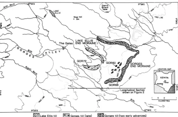
Between 2 8 5 0 m and 3 1 5 0 m in Gorges Valley, on t h e eastern flank Mount Kenya, a sequence of moraines (Fig. 1 ) and related sluiceways provide evidence for earlier glaciations as old as t h e Olduvai subchron
( 1 . 6 7 — 1 . 8 7 m y ) (MAHANEY, BARENDREGT & VOR
TISCH, 1 9 8 9 ) . In this paper t h e geomorphological evidence for these older glaciations-Gorges (older) and Lake Ellis (younger) — is described a n d discussed along with paleoclimatic / environmental interpreta-
2 M e t h o d s
Landforms were m a p p e d from, 1 : 5 0 0 0 0 stereo pairs (RAF photography 1 9 4 7 , 1 9 6 3 ) and LANDSAT ima
gery (Fig. 1 ) . Paleosol decriptions are based on criteria
established by t h e Son. SURVEY STAFF ( 1 9 5 1 , 1 9 7 5 )
and BIRKELAND ( 1 9 8 4 ) . Weathering rinds were meas-
^ i a n r a \ Billiard ) s T a b t e j
^XJ350
LAKE ELLIS The Gates I END MORAINE I
GOR 72
GOR60 0*
AM ^
SPA GOR6
„./GORGES
•9 END MORAINE,
L O C A T I O N M A P
Longitudinal Section shown on Figure 2
JLake Eltis till Gorges till (late) |Sgj||Gorges till (two early advances)
Fig. 1: Map of moraine limits, drainages and topographic features referred to in the text.
G O R G E S G L A C I A T I O N L A K E E L L I S G L A C I A T I O N 11
6 kilometres ED CREVASSE FILLING
ü l TILL and LOESS (local outwash) 3 3 TUFF
a. Waterlain Till at base
Fig.2: Landform profile showing morphosequences of deposits emplaced during Gorges and Lake Ellis glaciations. Glaciers moved from west to east;
largest expanded mountain ice sheet occulted during the eatlier Gorges Glaciation.
Fig. 3: Hummocky motaine deposited during the Gotges Glaciation (1.67 — 1.87 my) in Gotges Valley.
Lake Ellis End moraine
Left Lateral moraine
Fig. 4: Left lateral moraine (far right, background) emplaced during the Gorges Glaciation in Gorges Valley.
Ridge of Lake Ellis drift (left of center), alluvium of postglacial period covering older outwash of Liki, Teleki and Lake Ellis ages, and proximal slope of the Gorges Moraine complex (foreground, left and right).
ured using guidelines established by MAHANEY et al.
( 1 9 8 4 ) . Paleomagnetic samples were collected follow
ing standard procedures as discussed by BARENDREGT
(in MAHANEY et al. 1 9 8 4 ) a n d by BARENDREGT &
MAHANEY, 1 9 8 8 ) .
3 Landforms
T h e major glacial landforms (Fig. 1 ) consisting of meltwater channels, complex end moraine underlain with waterlain till, e n d moraines, ground moraines, hummocky moraines, crevasse fillings, a n d outwash plains were not described by previous workers on M o u n t Kenya (NILSSON, 1 9 3 5 ; BAKER, 1 9 6 7 ; HASTEN
RATH, 1 9 8 4 ) . T. J . CHARSLEY (personal communica
tion, 1 9 8 4 ) first recognized extensive moraines as low as 2 8 5 0 m on the eastern flank of t h e mountain, which were subsequently investigated by MAHANEY in 1 9 8 4 , 1 9 8 6 , 1 9 8 7 . 1 9 8 7 , 1 9 9 0 . This led to t h e iden
tification of morphostratigraphic units for two of the oldest glaciations — Gorges and Lake Ellis — on Mount Kenya. These units comprise a sequence of well-preserved deposits as shown in Figs. 2 through 5 .
3 . 1 E n d Moraines
End moraine complexes consist of one or two ridge systems, usually a b u t t i n g outwash fan deposits that are difficult to m a p from air photographs a n d satellite imagery. These moraine complexes are 1 0 0 to 2 0 0 m in width and 3 to 4 k m in length, standing only a few meters higher t h a n surrounding ground moraine.
All t h e end moraines are covered with t h i n veneers of aeolian sediment. Individual deposits of Gorges Till commonly contain two lodgement tills separated by loess, overlying waterlain till. These tills record at least two a n d possibly three advances of Gorges ice during the Olduvai subchron between 1 . 7 a n d 1 . 9 my ago
(MAHANEY, BARENDREGT & VORTISCH, 1 9 8 9 ) . Because
t h e lower beds in t h e outer Gorges moraine were deposited subaqueously along most of t h e length of t h e moraine, it is possible to make only limited inferences regarding ice dynamics a n d paleoclimate.
Fig. 5: Meltwater sluiceway in front of Gorges-age end moraine in Gorges Valley;
left, distal moraine slope; right outcrops of tuff of the Mt. Kenya volcanic suite (early Quatetnaty).
4 S e d i m e n t s 4.1 Subaquatic Sediments
Below the Gorges Glaciation lodgement tills, deposi
ted by ice moving from west to east in lower Gorges Valley, waterlain till has been observed at four loca
tions (Figs. 2 and 8). All sediments in this sequence exhibit horizontal bedding, lack appreciable deforma
tion (minor deformation is visible), and have sharp and abrupt upper contacts with overlying lodgement till (details of the stratigraphy in Fig. 8). These sedi
ments were deposited as poorly sorted beds about 2 — 4 cm in thickness that remain remarkably con
sistent with respect to particle size distributions from top to bottom. No subaquatic mass wasting or diamic- ton structures were observed, so it is possible to rule out episodic gravity flow deposition for these sedi
ments (such as described by EVENSON et al. 1 9 7 7 ) .
Subaquatic deposition of these sediments may have occurred under thin mountain ice actively receding
behind bedrock bars above the Nithi River outlet.
Because the underlying weathered tuffs were preserv
ed it is logical to assume that ice action was weak, and that sediment was being deposited subaqueously beneath floating ice, perhaps in shallow water dam
med by ice in the meltwater channels leading into the Nithi River or in the main Nithi Valley itself. Because this sediment contains pebbles that could be con
sidered dropstones, I measured the orientation of 50 clasts. The resulting fabric gave a bimodal distribution with stones oriented mainly toward 070° and 105°
(nine samples gave spurious readings). The presence of a glacial fabric and minor deformation of beds in these sediments favor a glacial rather than a glaciola- custrine origin. However, additional data is needed to rule out the latter hypothesis. This type of sediment is only observed in the outer Gorges moraines and may be linked possibly to catastrophic ice surges followed by rapid melting or to sudden paleoclimatic warming followed by rapid deposition of till.
4.2 Ground Moraines
Behind prominenr end moraine complexes a n d b e neath outwash a n d aeolian cover sediments, are numerous areas of ground moraine. In general, they are nearly flat topped and irregularly distributed in t h e landscape. Some are overlain with crevasse fillings that have been described as m a n - m a d e mounds (see MAHANEY et al. 1986, for discussion). A n u m b e r of exposures displayed irregular sequences of lodgement till with thin, sandy diamictons. Some may consist of crevasse fills or subglacial cavity collapse features, b u t most were probably formed prior to deposition of t h e hummocky-end moraine complexes. Deposition occurred on level or slightly sloping topography, pre
sumably u n d e r thick ice with relatively high subglacial water pressures.
4 . 3 Hummocky Moraine
Broad hummocky moraine occurs less than 1.0 k m be
hind the outer Gorges end moraine complex (Fig. 2).
Several asymmetrically shaped hills separate depres
sions filled with assorted till, fine laminated stratified drift, and p o n d e d sediments. T h e hummocky e n d moraines (Fig. 1) lie on the margin of a bedrock bar which was eroded by melrwaters issuing from b o t h Gorges a n d Lake Ellis ice. This geomorphic setting may have resulted from thick a n d active ice during t h e third Gorges advance, which led t o eventual t h i n n i n g followed by stagnation and Sedimentation of a range of clast sizes ( e . g . from boulders t o clay). These later advances emplaced deposits that are clearly different from the waterlain till in the outer end moraine com
plex, a n d possibly indicative of debris-covered ice (LAWSON 1981). Because the hummocky moraine belt is composed of thick drift ( ~ 30 m ) , deposition pro
bably occurred under active a n d thick ice conditions, followed by rapid stagnation a n d ice thinning t h a t led to emplacement of numerous crevasse fillings.
4.4 Lateral Moraines
Lateral moraine complexes, easily identifiable o n air photographs a n d LANDSAT imagery, define t h e outer margin of Gorges ice when t h e expanded m o u n t a i n ice sheet occupied almost all of Gorges Valley a n d one u n n a m e d tributary drainage t o t h e north (Fig. 1).
These moraines have steeper slopes and sharper crests compared with t h e end moraine complexes; they are 5 — 7 km in l e n g t h , 50 to 150 m wide and up t o 25 m high. Commonly they have single crests and together they account for a greater a m o u n t of sediment accu
mulation when compared with t h e end and g r o u n d moraine complexes.
4.5 Crevasse Fillings
Behind a n d around the hummocky belt an irregular distribution of conical m o u n d s consisting of till a n d stratified sediments were interpreted to be crevasse fillings. Originally interpreted as man-made m o u n d s (ZEUNER 1948) these deposits appear related to thin
ning and eventual breakup of t h e expanded mountain ice sheet following the third advance of ice during the Gorges Glaciation.
4.6 Outwash
Between t h e hummocky moraine belt of the Gorges Glaciation a n d t h e e n d moraines of Lake Ellis age (Fig. 2) a system of outwash deposits, built by streams flowing from active ice to t h e west, forms prominent terraces and fans in the landscape. While some of this outwash could have been deposited following t h e Gorges Glaciation, the major proportion appears to belong t o t h e younger Lake Ellis Glaciation. Unlike the older Gorges Glaciation which left much of t h e underlying weathered bedrock intact, younger o u t - wash of Lake Ellis age is found commonly in thin bodies ( 2 — 4 m thick) over scoured and fresh bedrock surfaces.
4.7 Aeolian Sediments
Wind blown sediments cap much of the outwash and till deposits (ZEUNER 1949), and in some cases (mainly around the margin of glaciation) even separate buried till sheets ( e . g . Section G O R 6 8 , Fig. 8). As in other drainage basins around Mount Kenya aeolian sedi
ments are high in quartz a n d low in ferromagnetic minerals when compared with tills (MAHANEY 1982;
VORTISCH, MAHANEY & FECHER 1987). Many of these
aeolian deposits ate thin ( ~ 0.5 m ) and almost all are weathered forming A or A b horizons in paleosol sequences. Many contain histic or mollic epipedons
(SOIL SURVEY STAFF, 1975) of considerable thickness
that were formed under Afroalpine biotic elements during deteriorating climate when majot vegetation belts occurred further down t h e mountain, a distance
of at least 600 m (MAHANEY, HARMSEN & SPENCE
1991).
5 W e a t h e r i n g
Weathering features on surface stones are only of limited use in distinguishing between Gorges a n d Lake Ellis deposirs. This is partly the result of t h e location of deposits under differenr vegeration belts
— Gorges moraines are situated under Hagenia wood
land at present, whereas Lake Ellis drifts are under ericaceous vegetation (Fig. 1). Also several weeks of
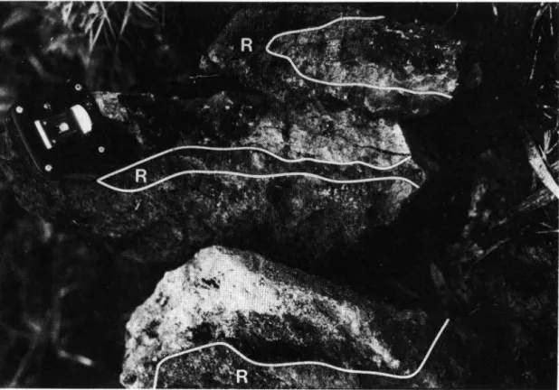
Fig. 6: Weathering rinds from outer Gorges end moraine, Nithi River Basin, Mount Kenya; R — rind (rock surface weathered to clay and Fe oxides).
observations in 1 9 8 3 / 8 4 , 1 9 8 6 a n d 1 9 8 7 showed that advection currents tend to force air masses upward to
~ 3 0 0 0 m bringing rain t o approximately t h e same elevation. Above ~ 3 0 0 0 m climate is noticeably drier — t h e boundary coincides with Gorges a n d Lake Ellis deposits. Hence, stones on Gorges deposits are not only in a wetter microclimate, they are also older and have been exposed to subaerial weathering for a longer period of time. The result is that clasts on Gor
ges deposits (Fig. 6 ) have weathered to produce thick ( 2 0 t o 3 0 m m ) clay and oxide-rich rinds. Stones on Lake Ellis drifts are somewhat fresher, although they can be split easily with a h a m m e r .
6 S t r a t i g r a p h y
The Gorges a n d Lake Ellis glaciations on Mount Kenya occurred prior to the Matuyama / Brunhes boundary
( > . 7 3 — . 7 9 my) (Fig. 7 ) , a n d spread to 2 8 5 0 m o n
the eastern side of the m o u n t a i n . Deposits emplaced during t h e earliest phase of t h e Gorges Glaciation (Fig. 8 A) generally have normal magnetism w i t h r e v e r s e d o v e r p r i n t s suggesting t h e tills
were emplaced during t h e Olduvai subchron (see
MAHANEY, BARENDREGT & VORTISCH 1 9 8 9 , for discus
sion). Tills emplaced during t h e later phase of t h e Gorges Glaciation (Fig. 8 B ) have strongly reversed
EPOCH
GEOLOGIC UNIT
GEOMAGNETIC POLARITY
N A R O M O R U / L A K E ELLIS I N T E R G L A C I A T I O N
L A K E ELLIS G L A C I A T I O N
L A K E E L L I S / G O R G E S I N T E R G L A C I A T I O N
G O R G E S G L A C I A T I O N
I
1
N O R M A L R E V E R S E DOlduvai Subcron
Fig. 7: Early to Middle Pleistocene stratigraphy of Mount Kenya, East Africa.
remanent m a g n e t i s m , which w o u l d indicate an age possibly in t h e middle of t h e Matuyama C h r o n . Younger drifts a n d outwash of Lake Ellis age (Fig. 8 C ) give strongly reversed remanent magnetism suggesting possibly an u p p e r Matuyama age, presumably closer to t h e Matuyama / Brunhes b o u n d a r y (Fig. 7 ) . T h e Jaramillo subchron, although of limited duration, h a s never been identified in any of t h e paleomagnetic samples collected on Mount Kenya (R. W. BAREND- REGT, personal communication, 1 9 8 7 ) .
they could also reach some exposed kenyte (commonly outcrops today at ~ 4 6 0 0 m ) . T h e data presented by MAHANEY, BARENDREGT & VORTISCH ( 1 9 8 9 ) indicate that it took nearly 1 . 0 million years to remove most of the roof rock complex; subsequent removal of plug rock and formation of existing cirques in the Central Peaks area took a b o u t three quarters of a million years (for details on t h e erosion history see MAHANEY, HARMSEN & SPENCE 1 9 9 1 ) .
7 Conclusions
GOR68 GOR60 GOR72
UB22
Sun
%VB2b
VCIoxb
Al B2lt B22t EClox EC2ox
_ EC3ox
-
WM$ EC4ox
MC5
EB2I
EB22
UCox
*>%KKiS£$!3C2oxbm
EE3
L 0 E S SUS TILL
WATERLAIN TILL SANDY OUTWASH WEATHERED CLASTS
%p UNWEATHERED CLASTS
fHfJ ROOTS
This investigation of previously undescribed glacial landforms has led to a sequential arrangement of end moraines (with or without waterlain till), ground moraine, hummocky-end moraines (with crevasse fillings in the older group) a n d outwash that form distinctive morphosequences related to the earliest cycles of glaciation on Mount Kenya. Each morphose- quence can be interpreted with respect to glacier dynamics and paleoclimate that provide important information about paleoenvironmental reconstruction in the tropical Afroalpine. T h e landform morphose- quence is considered to represent t h e following glacial sequence: (a) thin ice flow depositing waterlain till in the outer Gorges e n d moraine complex; (b) some- what more aggressive ice conditions leading to deposi- tion of two tills separated by aeolian sediments; (c) deposition of hummocky-end moraines during an interval when ice appears to have been capable of moving considerable debris followed by stagnation a n d development of numerous crevasse fillings; a n d (d) development of an end moraine sequence in Lake Ellis time accompanied by emplacement of significant ground moraine a n d outwash bodies. T h e Lake Ellis Glaciation appears to have resulted from the simple forcing of a deterioriating paleoclimate, whereas t h e earlier Gorges Glaciation left a m u l t i t u d e of different landforms with important paleoenvironmental ramifi- cations.
Fig. 8: Stratigraphy of tills, outwash, and loesses in sections (A) GOR 68 (outet Gorges moraine);
(B) GOR 60 (hummocky moraine of Gorges age);
(C) and GOR 72 Lake Ellis age moraine.
Clast composition in both the Gorges and Lake Ellis deposits consists entirely of basalt w i t h minor amounts of kenyte (glassy phonolite) appearing in the younger suite of samples. This suggests t h a t d u r i n g the Gorges Glaciation ice was eroding only roof rocks of basalt which still covered the volcanic p l u g of the m o u n t a i n . During the ensuing Lake Ellis Glaciation glaciers were still excavating mainly basalts, b u t t o a depth where
8 A c k n o w l e d g m e n t s
This research was partially supported by grant A 9 0 2 1 of the Natural Sciences and Engineering Research Council of C a n a d a . STEVE HICOCK a n d ALEKSIS DREIMANIS (University of Western Ontario) critically reviewed the manuscript. The abstract was translated into German by WOLFGANG ANDRES (Philipps Univer- sität, Marburg, F . R . G . ) . Samples were analyzed in t h e Geomorphology a n d Pedology Laboratory in Atkinson College at York University with assistance of DAVID HlNBEST. Field work was carried o u t with the per- mission of t h e Office of t h e President, Republic of Kenya. JANET AlXIN drafted t h e illustrations.
9 References
BAKER, B. H. (1967): Geology of the Mount Kenya Area.
— Rept. No. 79: 78 p . ; (geological Survey of Kenya).
BARENDREGT, R. W. (1984): Using paleomagnetic re- manence and magnetic susceptibility data for the differ
entiation, relative correlation and absolute dating of Quaternary sediments. — In: W. C. MAHANEY (Editor), Quaternary Dating Methods: 101—122; Amsterdam (Elsevier).
— & MAHANEY, W. C. (1988): Paleomagnetism of selected Quaternary sediments on Mount Kenya, East Africa: a reconnaissance srudy. —J. African Earth Sciences, 7(1):
219—225; Oxford, Frankfurt/M.
BIRKELAND, P. W. (1984): Soils and Geomorphology. — 372 p . ; Oxford, N . Y . (Oxford Press).
EVENSON, E. B., DREIMANIS, A. & NEWSOME, H. (1977):
The subaquatic flow tills: a new interpretation for the genesis of some laminated till deposits. — Boreas, 6:
115—134; Oslo.
EVERDEN, J. F. & CURTIS, G. H. (1965): The potassium- argon daring of late Cenozoic rocks in East Africa and Italy. — Current Anthropology, 6 (4): 343—385.
GREGORY, J. W. (1894): The Glacial Geology of Mount Kenya. — Quart. Jour, of the Geological Society, 5 0 : p. 515—530.
— (1900): The geology of Mount Kenya. Quart. —Journ.
Geol. Soc, 56: 205—222.
HASTENRATH, S. (1984): The Glaciers of Equatorial Africa.
— 353 p . ; Dordrecht (Reidel).
LAWSON, D. E. (1981): Sedimentological characteristics and classification of depositional processes and deposits in the glacial environment. — U.S. Army Corps, of Engi
neers, CRREL Report: 81—27; Hannover, N . H .
MAHANEY, W. C. (1979): Reconnaissance Quaternary strati
graphy of Mount Kenya, East Africa. — In: E. M. VAN
ZINDEREN BARKER & J. A. COETZEE (Editors), Palaeoecol- ogy of Africa, 10: 163—170; Rotterdam, Balkema.
— (1990): Ice on the Equator, Sister Bay, Wise., Wm
Caxton Ltd., 386 p.
MAHANEY, W., BARENDREGT, R. W., CHURCHER, C. S. &
SPENCE, J. (1985): Gorges Valley rock shelters, Mounr Kenya Afroalpine area, East Africa. — Nyame Akuna, 26: 21—25.
— , — & VORTISCH, W. B. (1989): Quaternary glaciations and paleoclimate of Mount Kenya, East Africa. — In: OERLEMANS, J.: Glacier Fluctuations and Climatic Change: 13—36; Dordrecht (Kluwer).
— , HALVORSON, D., PIEGAT, J. & SANMUGADAS, K. (1984):
Evaluation of dating methods used to assign ages to Quaternary deposits in the Wind River and Teton Ranges, western Wyoming. — In: W. C. MAHANEY
(Editor) Quaternary Dating Methods: 355—374; Am
sterdam (Elsevier).
—, HARMSEN, R. & SPENCE, J. R. (1991): Glacial-inter- glacial cycles and development of the Afroalpine eco
system on East African mountains. — J . African Earth Sciences, 12: 505—512.
NILSSON, E. (1931): Quaternary glaciarion and pluvial lakes in Bristish East Africa and Abyssinia. — Geog.
Annaler, 1 3 : 241—348.
— (1935): Traces of ancient changes of climate in East Africa. — Geog. Annaler, 1 2 : 1—21.
Son. SURVEY STAFF (1951): Soil Survey Manual. — Washington, D.C. (U.S. Government Printing Office).
— (1975): Soil Taxonomy. — Agriculture Handbook:
436 p . ; Washington (U.S.D.A.).
VORTISCH, W. B., MAHANEY, W. C. & FECHER, K. (1987):
Lithology and weathering in a paleosol sequence on Mount Kenya, East Africa. — Geologica et Paleontol- ogica, 2 1 : 245—255; Marburg/Lahn.
ZEUNER, F. E. (1948): Climare and early man in Kenya.
— Man, 48: 13—16.
— (1949): Frost soils on Mount Kenya and the relation of frost soils to aeolian deposits. — J. Soil Science, 1:
20—30; Oxford.
Manuscript accepted 20. March 1990, supplements September 1990.