*Corresponding author:Narantsogt Nasanbayar
Department, School of Civil Engineering and Architecture Mongolian University of Science and Technology, Ulaanbaatar, ISSN: 0976-3031
Research Article
ICING MAR METHOD FOR SEMI-ARID, HIGHLY CONTINENTAL REGION
(AN EXAMPLE AT ULAANBAATAR CITY, MONGOLIA)
Narantsogt Nasanbayar
Department, School of Civil Engineering and Architecture Mongolian University of Science
and Technology, Ulaanbaatar, Mongolia
DOI: http://dx.doi.org/10.24327/ijrsr.2019.1010.4070
ARTICLE INFO ABSTRACT
Ulaanbaatar, the capital of Mongolia, exhibits dynamic urban and industrial development with rapidly increasing population numbers. Against the background of this situation, water demand is rising continuously, but water availability is comparatively low and less reliable.
A groundwater aquifer located near Ulaanbaatar, is the city’s only source of water, with the main watercourse in the vicinity being the Tuul River, fed by precipitation in the nearby Khentii Mountains.
For many decades, the water supply of Ulaanbaatar has been exclusively based on the use of groundwater in the Tuul valley, but as the city grows, ensuring water availability to Ulaanbaatar’s population both now and in the future has become a pressing issue. There are two principal hurdles to overcome in addressing this situation.
First, due to the winter coldness and absence of precipitation during spring, the Tuul River usually runs dry during these seasons. Observations show that this dry period has been extending in recent years.
Second, in parallel with the city’s increasing development, the extended groundwater aquifer is exhibiting a clear decline, with groundwater levels dropping significantly.
Therefore, we propose a groundwater management system based on managed aquifer recharge and present a strategy to implement these measures in the Tuul Valley. It consists of an enhancement of natural recharge rates during the summer flood period, an increase of groundwater recharge through melting ice in the riverbed, and the construction of underground dams to retain groundwater.
INTRODUCTION
Study area
In 2014, the population of Ulaanbaatar, Mongolia’s capital city reached 1.345 million, about 45 percent of Mongolian total population, with the city producing about 65% of its national GDP. Ulaanbaatar’s water supply depends on wholly of groundwater aquifers along the Tuul River valley on the southeastern side of the city. Ulaanbaatar’s water consumption had reached around 100 M.m3 per a year. Mongolia’s fast-growing economies combined with widespread migration to the capital are putting more and more strain on the groundwater resources in the Tuul River valley.
The Tuul River flows through Mongolia’s capital along the borderline of the Siberian Taiga forest and dry steppe lands of central Asia near Ulaanbaatar. The water level of the Tuul River fluctuates according to annual high-flow to low-flow
cycles, with its average water flow being 24,94 m3/s. It also feeds the aquifer that providing Ulaanbaatar’s water supply. Ulaanbaatar’s water consumption has grown significantly with the increasing economic development experienced over the last 10 years. Groundwater resource issues, including water scarcity and negatively impacted water quality downward of the city have been identified as a major threat through the dry season, when Tuul River dries out. With the city’s water needs increasing while it’s groundwater aquifer and its streamflow shrinks. The recharge capacity of the aquifer is also being increasingly compromised. The advent and duration of the Tuul River’s dryness is coming earlier and lasting longer year to year.
Climate
The climate of the region is extreme, with large fluctuations in daily and annual amplitudes of air temperature and low precipitation.
International Journal of
Recent Scientific
Research
International Journal of Recent Scientific Research
Vol. 10, Issue, 10(B), pp. 35272-35278, October, 2019
Copyright © Narantsogt Nasanbayar, 2019, this is an open-access article distributed under the terms of the Creative Commons Attribution License, which permits unrestricted use, distribution and reproduction in any medium, provided the original work is properly cited.
DOI: 10.24327/IJRSR CODEN: IJRSFP (USA)
Article History:
Received 6th July, 2019
Received in revised form 15th
August, 2019
Accepted 12th September, 2019
Published online 28th October, 2019
Key Words:
The average annual temperature is minus 3,10С at absolute maximum 390С in July and an absolute minimum of minus 490С in December. Average absolute minimum air temperature is minus 410C. Low winter temperatures in the low cover snow cause permafrost in soil 10-15m thick. [8]. Below are shown recorded extreme climate parameters in the Ulaanbaatar city wetter station. The Ulaanbaatar terminal site is due to evaporation and infiltration the clayey soils are slight to medium heaving soils in seasonal freezing depth. [7]. The duration of the cold period is 187 days with average daily air temperature under 00C days. The average beginning and lasting dates of the frosty period are October 9-th and 14-th of April, respectively. Annual rainfall is 261mm. Distribution of rainfall during the year is uneven, about 90% of annual precipitation falling during the warm period between May and September. The daily maximum precipitation reaches 75 mm. During the course of the year, the Ulaanbaatar area is dominated by north west, north and south easterly winds. The highest wind speed is observed in spring and autumn.
Hydrogeological condition
Alluvial aquifer valley Tuul river deposits having ubiquitous within the Central source area, characterized by report material RIBES. /Research Institute on Building Engineering Studies. (1979)/ and other organizations.
In most of the considered site aquifer has a two-layer structure. The upper aquifer horizon is confined to deposits of the surface, to the top of the lower layers having a sufficiently high water permeability. The lower aquifer is enclosed in the bottom sediments of the rock formation.
Both layers are hydraulically interconnected but differ in the composition of water-bearing rocks, and watery. Whole Aquifer and the upper aquifer stratum are unconfined and contain free groundwater. Waters enclosed in the lower aquifer, sometimes becoming head due to the presence in its roof loamy lenses and interlayers. When drilling wells set the overall level of both aquifer stratums.
Under the conditions of undisturbed mode, the depth of the water table in the lowest position of (winter - spring period) varies from 2-6 m, and at the highest within 0,5-5 m (summer - autumn period).
On the site of intake, depth of the decline in groundwater levels for individual wells reaches 10-13 m at high standing groundwater table, 15-19 m at its lowest position.
Water supply Ulaanbaatar city
Water supply current and future options for Ulaanbaatar city depend wholly on the aquifer in the valley Tuul River south of the city. The city has been supplied by deep wells that draw on groundwater sources from an unconfined aquifer that runs along the bed of the river, exploiting additional alluvial deposits from the Tuul River’s tributaries. Ground water is the only source of drinking water supply in Ulaanbaatar capital city of Mongolia. Ulaanbaatar’s domestic water supplies are extracted from 198 deep wells, located in four sites: the “upper source” just below the confluence of the Rivers Terelj and Tuul in the upper basin, and the three other sources - “central”, “industrial”, and “meat factory”-in the city itself. In 2015 established two more group intake wells named Gatsuurt
source upper side of central source area with 20 wells and Airport source next to power plants source with 20 wells for new city district. Today, water supply agency distributes some 168.4 T.m3/day* of water for domestic use. The company estimates that another 130 T. m3/day pumped from the aquifer by private wells run by industries and individuals.
Figure 1 Groundwater aquifer sources for city water supply
At around 168.4 M.m3 /year*= 461T.m3/day water consumed in year 2010 for domestic water supply, that the city uses twice as much water as it was doing 20 years ago, and that thirst looks set to continue to grow.
Groundwater balance per a year
Tuul river basin has a common feature of Mongolian climate, sharply continental climate and far from the ocean conditions therefore surface and underground water resources consist of only the recharge from the precipitation. The aquifer in the Tuul river valley is relatively reliable source for water supply, recharged by surface river flow and surface water flow which recharged by summer precipitation and snow melt mountains. Ulaanbaatar water supply and existence whole depends on Tuul river valley and about 30 km long aquifer southern side of Ulaanbaatar.
The balance calculation rate estimated by subtract total pumped groundwater from the sum of the inflows-river flows, precipitation and reuse water thermos power plants.
Above estimated calculation is considered whole total water supply upper and city central sources of Ulaanbaatar aquifers with Tuul river annual average flow rate.
Value is the total water balance of the groundwater source area varying multiyears depending on the dryness of the year. Total amount of water used for water supply in non-recharging season reaches about 20mio.m3 depends on from weather condition and generally from precipitation thus year.
From this balance table could estimate water volume gap, which is in red highlighted, pumped from aquifer in dry season without recharging from river.
The pumped sum of groundwater 20 M.m3 using for water supply city in winter and dry season where non rechargeable from river /frozen until bottom or dry bed without ice, those could reserve and store in central source aquifer area.
Water balance between recharge and pumped water amount in the central source area without technical purpose water supply for thermos power plants is about -7.1 M.m3 water. Thus, amount of water should we recover and supply using managed aquifer methods.
In central source area in Ulaanbaatar aquifer pumped water without recharging is reached -7.1 M.m3 water which is generated in porous media a gap air with water vapor while Tuul River ice covered and dried out from end of November until April.
Concept model of water supply aquifer Ulaanbaatar
The study area is located in the middle-upper part of the Tuul River, which is belongs to the catchment basin of Baikal see.
Figure 2 Conceptual model box of inflow and outflow water rate of aquifer
Annual rainfall is 261mm/year. The daily maximum precipitation reached 75 mm. The total precipitation at Ulaanbaatar is on average 275 mm (1986-2006). The months with the highest precipitation are June, July, August and September. For a FEFLOW simulation neglected winter snow precipitation only used difference between rainfall and evaporation rate 11mm/year as Inflow on top.
For the groundwater aquifer concept model estimation also used borehole data which was for water accumulation flow control reservoir survey data. PRIESC monitored observation borehole data starting from upper I to down XXIII cross sections, therefore data source used of dam axis variation for surface water accumulation reservoir. [18]
Figure 3 3D /FEFLOW/ concept model of aquifer area
Above showed picture is FEFLOW geometry 3D model of the Tuul river groundwater aquifer locating southern side of the city Ulaanbaatar from this aquifer city pumping 70% of domestic water supply for itself.
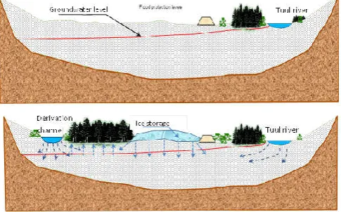
Managed aquifer recharge method
Application of MAR combining with icing methods
The Central source of drinking water supply system is extracting from 93 ground water wells with deep well pumps, 7 booster pumping station. The capacity of source is 114000 m3/day. Nowadays water extraction from 70-80 wells and its volume reaches 87-90 tousand.m3/day supply to capital city [14].
The research work will be conducted through central source branching Tuul River near Gachuurt, derivate flowing into the old river channel, making percolation channel, recharge basin and injection funnel well and using methods to increase water resource. It includes of digging channel to take water in the river bench, flowing into the river old channel.
A channel will be digged in the bench of river bank from the upper side of the Central source and water will be derivate flown into the old channel.
In order to flow by the old channel additional embankments water abstraction structures could be done in two places of currently existing embankment. In this way water will be brought by the drainage channel into the initial operating wells of the central source upper part.
It enables to additional recharging water by melting from ice storage in low flow months March and April. The method relies on making ice storage in winter by pumping artificial resources of underground water.
Figure 4 Central source upper area aquifer profile in Ulaanbaatar, artificial
recharging methods
Underground ice wall in the end of western part
In the end of drainage canal would be surface spreading recharging basin which drain and filtrating surface water to the ground. Also, in the western part of area would be built underground ice dam that’s retarding and slowing underground water flux and increase groundwater level upper side. In the lower side of the central source upper part area where Uliastai and Tuul river confluence near to each other create artificial permafrost or underground ice wall dam.
Table 1 Water exploration volume balance for water supply Ulaanbaatar city
Months IV V VI VII VIII IX X XI XII I II III Total
Balance
[M.m3] 10.95 79.72 125.38 216.15 231.68 135.96 42.82 5.81 -4.23 -5.74 -5.56 -4.76 828.18
This dam will be increase ground water table in Central source and help provide creating artificial lake, drainage basin or drainage pond.
The underground ice dam will be 10m deep, 1-1.5m wide digging canal excavated early winter and harsh winter -40degree C create underground artificial ice block wall after that it will be cover with soil and planting trees and bushes. The underground water flux flowing by both side and under of ice wall directing to the confluence stream and mean stream of Tuul river.
Feflow Simulation Central Source A Zone
Model area
The water intake area with group of wells named A zone is located in the eastern part of the Central source area and has 22 wells, located in three rows. In this zone tributes two rivers Uliastai from north side and Khul river from south side and the area of A zone restricts west side with Uliastai river and south-eastern side with Tuul river.
The main source of groundwater operational reserves in the water intake area in the dry season between December to April, where is lack of river flow, are natural reserves, annually fills river runoff infiltration loss of the Tuul river surface water. In the period wet season from May to November formation of groundwater operational reserves infiltrated groundwater from river surface water /leak of river water/ and groundwater flux infiltration losses from Tuul river.
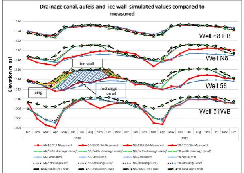
The data of groundwater drawdown in monitoring wells 51, N8, 68 shown in next figure used as Eastern and Western boundary conditions and calibration for groundwater fluctuation. The sensitivity analyses for FEFLOW simulation to identify which parameter variation more sensible to optimize
simulation results and calibration. In the FEFLOW model
varied some parameters by simulation run and noted that which simulated parameter more sensible to the simulation results and measured groundwater level.
Sensitivity analyses
The sensitivity analyses for FEFLOW simulation to identify which parameter variation more sensible to optimize simulation results and calibration.
In the FEFLOW model varied some parameters by simulation run and noted that which simulated parameter more sensible to the simulation results and measured groundwater level.
Graphic 1 Sensitivity analyses of FEFLOW simulation
From above figured graph shown that Hydraulic conductivity variation is more sensible in simulation results. The calibration of simulated and measured values ratio was chosen hydraulic conductivity.
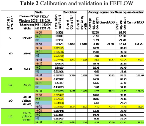
Calibration
The calculation of the operational groundwater reserves in accordance with the above conditions for their formation, and also taking into account the need to solve the loop and inverse problems for evaluating the functional reliability of the assumed design parameters and obtaining the initial conditions, can be realized only in the result of realizations of mathematical models describing both steady and transient filtering groundwater in a three-dimensional mode in terms of unconfined flow.
The calibration of hydraulic conductivity and determination of calculated hydrogeological parameters initial data for the calculation of reserves. [1]
In the calibration used Microsoft Excel function – CORREL, DEV SQ average and mean squared deviation function.
Reverse validation method
For a validation, used reverse validation method, which presents as changing small-simulated area to large area and ex boundary condition well monitored as for a validation.
Table 2 Calibration and validation in FEFLOW
FEFLOW Simulation scenarios
In accordance with the described nature of the interrelationship of surface and groundwater, the estimation of operational reserves is reduced to the selection of such productivity of water intakes, at work with which their dynamic level
There are four possible types of regulation, only one of them is conventional method of MAR and others using cold weather reserve ice as water source for dry season.
The first type of Artificial recharging is a specially constructed drainage canal redistributing river flow in Northern side of area.
The third type of regulation is making underground permafrost blocking groundwater flux in western boundary. This increase upper side groundwater level.
The fourth type of regulation is promoting ice creation in river bed by reducing river flow energy using hydraulic structure such as fish passage barrier stones.
Figure 5 The possible scenarious to increase groundwater
Drainage canal
The first type of Artificial recharging is the spatial redistribution of the surface runoff, when part of it is passed through a specially constructed canal, and in the main river bed the natural regime remains, minus the flow that passes through the channel.
The water supply to the canal begins after the river runoff reaches the western boundaries of the Central section and continues as long as its flow provides losses that go to replenish the groundwater reservoirs from the river and canals. At the expense of the river, not providing these losses, water supply to the canal stops, and in the river, its natural regime remains.
Icing-Icing promoting ice creation methods
There are three types of promoting ice creation ways in cold region in winter.
On the ground surface
In the underground open pit
on the river bed
Underground ice dam- Ice wall
The underground permafrost wall which blocking groundwater flux in western boundary would be increase upper side groundwater level.
When blocked western boundary with ice wall from bottom to 1310 m.asl means boundary condition in surface increase to elevation 1310 m.asl. Ice wall created with krone elevation 1310m.asl which allows accumulating all incoming groundwater fluxes. The artificial ice wall will be created non flux condition in western boundary which allows us to store more water in ground over 3.4 M.m3 water.
When combining all possible artificial recharging methods drainage canal, icing and ice block then recharging water amount 4.5 times more than only ice block method.
It is possible combine ice wall building location in a river valley considering another infrastructure such a road, railway, flood protection levee then it is possible between road and levee in left side of Railway Bridge.
Figure 6 Possible ice dam location in first layer on western boundary
The technical spatial opportunity, infrastructures gives us such a limited possibilities and it is possible artificial recharging all of icing methods in the area. Also is technical possible only until 5-10 m to digging and freezing ice and to create artificial permafrost wall. This is fits good in first layer.
The all combination results in excel table is below graph The technical spatial opportunity, infrastructures gives us such a limited possibility and it is possible artificial recharging all of icing methods in the area. Also, is technical possible only until 5-10 m to digging and freezing ice and to create artificial permafrost wall. This is fits good in first layer. The all combination results in excel table is below graph.
The following graph demonstrate that all combination of three variation to increase groundwater recharge promoting each other’s fill gap of other and give best increased amount of groundwater resources.
Graphic 2 The all variation combination in simulated area compare to
Increased max abstraction rate variation of multilayer wells
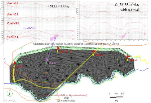
To do find total additional water resource recharged by Northern drainage canal and Ice storage should increase abstraction rate until maximum possible rate when GW drawdown decrease under bottom of wells filter screen, soaks up air. Let us take a look groundwater table fluctuation in maximum abstraction rate, by group of 23 wells for a day without MAR methods.
The groundwater fluctuation graph of monitoring well N8 shown that, by increasing rate 60.9 T.m3/day is could not intake water while groundwater drawdown is under bottom screen. But in the middle of group of wells where happens extreme drawdown of groundwater there only 45.1 T.m3/day is possible. Therefore, maximum abstraction rate of this area is 45.1 T.m3/day, which means 16,469,165.0m3/year=16.5M.m3 water per year.
When the Northern drainage canal which derivate river surface water, recharging in wet seasons and on the end release water in open surface which create icing in October to November then maximum abstraction rate increases until 70133 m3/day=25.6 M.m3/year. There 2 simulation results with Ice wall and without ice wall in western boundary but by maximum abstraction of groundwater, the flux disruptive Ice wall doesn’t play role. The following figure shows increased possible maximum abstraction until 70133m3/day with and without ICE wall, northern drainage canal and ice storage which gives additional recharge groundwater.
Figure 7 Increased maximum abstraction rate to 70133m3/day
Difference between above maximum abstraction simulations shown 9.125 M.m3 could additional groundwater during wet season could keep as reserve.
The percent of increased amount of water reserve by each method in combination of MAR methods increased groundwater sources is following.
drainage canal brings 73.5 % of artificial recharging 6.7 M.m3 water
Ice storage keeps water in ice form 21% mean 1.9 M.m3
Ice wall keep 5,65%, 516 T.m3 recharged groundwater.
Such a way using coldness and ice formation in semi-arid, highly continental region could be increase groundwater
resources. This nonconventional artificial recharging methods like ice storing helps groundwater recharge in dry season where no flow and dry bed in river systems.
CONCLUSION
The Tuul river valley and his tributaries are good example to do Icing storages in early winter season where river surface water begins flowing under ice cover. Hydraulic structures such as drainage canal and underground dams increase groundwater levels also help to escape groundwater from underground like as Springs, extending, freezing and filling lower holes and ravines until same horizontal elevation create. Nature friendly method enhancing to create ice storage blocks at the river valley in winter season due to groundwater delaying or blocking and enhancing ice block formation.
This hydraulic method helps to build ice storage in the riverbed and increase natural flow in spring dry season by melting.
Results from this analysis can conclude as follows:
During the summer period, when discharge of the Tuul river is at its maximum, diversion canals could branch off water from it to drainage canals, where infiltration helps to increase the groundwater levels. During low flow periods in winter and spring, the artificially increased groundwater could be pumped for water supply of the city.
Underground ice dams, potentially made of artificial permafrost, will help to retard groundwater flux in the river valley and to increase the groundwater levels in the near of drinking water extraction wells
Around the drainage canals, natural grown bushes and trees as well as designed recreation areas could renature the environment for the local population.
A positive side effect of increased evaporation from the open water springs is that air humidity will be increased which will lead to artificial precipitation and a deposition of atmospheric particles from air pollution and thus helps to improve air quality in the city and its surroundings.
References
1. Anderson MP, Woessner WW (1992) Applied Groundwater Modeling: Simulation of Flow and Advective Transport. Academic Press, 281 p.
2. Ashton, G. D., Deterioration of floating ice covers, J. Energy Resour. 177-182, 1985
3. Carl D. McElwee; M. Arif Yukler (1978): Sensitivity of groundwater models with respect to variations in transmissivity and storage
4. Davaa Gombo, Erdenetuya Magsar Hydrological Changes in the upper Tuul River Basin (2004) Institute of Meteorology and Hydrology, Information and Computer Center, Juuljinii St. 5, Ulaanbaatar-46, MONGOLIA
5. Davaa, G. (2008), Surface water resources in Mongolia. 6. Dashjamts. D, (2015) Permafrost and geotechnical
investigations in Nalaikh Depression of Mongolia [J]. Sciences in Cold and Arid Regions, 7(4): 438-455. 7. Dashjamts. D, (2015) Permafrost and geotechnical
8. Dashjamts, D. (2013) Geotechnical problems of construction on permafrost in Mongolia, Sciences in Cold and Arid Regions, 5(5): 0667–0676
9. Dillon, P., Pavelic, P., Page, D., Beringen, H. & Ward, J. (2009): Managed aquifer recharge: an introduction. Waterlines report series 13, Australian Government, 65 p.
10. De Bruin, H. A. R., and H. R. A. Wessels, A model for the formation and melting of ice on surface waters, J. Appl. Meteorol.,27, 164-173, 1988.
11. Froehlich, Wojciech; Slupik, January (1982). French, H.M., ed. "River icings and fluvial activity in extreme continental climate: Khangai Mountains, Mongolia" (PDF).
12. GIM- Geo-ecology Institute Mongolia (1997): The research works report of Tuul River water reserves decreases reason, protection provision UB. -
13. GIM - Geoecology Institute of Mongolia (1999): “The ecological assessment of Tuul River” Report UB 14. GIM - Geoecology Institute of Mongolia (2010): The
report of water quality, aquatic environmental ecology study
15. Hu, Xiaogang; Pollard, Wayne H. (September 1997). "The Hydrologic Analysis and Modeling of River Icing Growth, North Fork Pass, Yukon Territory, Canada". Permafrost and Periglacial Processes. John Wiley & Sons. 8 (3): 279–294.
16. Neven Kresic. Hydrogoelogy and Groundwater Modelling. 2nd edition. 2007
17. SIWRMM “Strengthening Integrated Water Resources Management in Mongolia” project. Tuul river basin integrated water resources management assessment report. (2012).
18. RIBES-Research Institute on Building Engineering Studies. (1979): Technical report of engineering survey TOM-2. Moscow. ПНИИИС-Производственный и научно-исследовательский институт по инженерным изысканиям в стройтельстве, (1979): Технический отчёт об инженерных изысканиях ТОМ-2 , Москва. 19. Sltelli, A. (2002). "Sensitivity Analysis for Importance
Assessment". Risk Analysis. 22 (3): 1–12.
20. Strengthening Integrated Water Resource Management In Mongolia project. SIWRMM (2013): Groundwater model for UB. iMOD
21. SIWRMM. Tuul river basin integrated water resources management assessment report. 2012 11.
22. Unurjargal. D. (2009) “Report of research works on Groundwater monitoring measurements data “Ulaanbaatar
How to cite this article:
Narantsogt Nasanbayar., 2019, Icing Mar Method for Semi-Arid, Highly Continental Region (an Example at Ulaanbaatar city, Mongolia). Int J Recent Sci Res. 10(10), pp.35272-35278. DOI: http://dx.doi.org/10.24327/ijrsr.2019.1010.4070