Application of Satellite Communication & Remote Sensing
for Development
Eshwari, Ashutosh Pandey and A. K. Shrivastava
DepartmentofPhysics,
Dr. C.V. Raman University, Kota, Bilaspur, Chhattisgarh, INDIA.
(Received on: June 6, Accepted: June 8, 2017)
ABSTRACT
The advent of communication satellite and remote sensing individually as well as jointly, are playing a significant role in the development and inclusive growth of the rural and urban areas in India. The applications of remote sensing include forest and wastelands mapping, use/land – cover mapping, land – form and land-degradation studies, agriculture and soil mapping, ecology and Geo-sciences and geo-morphologic mapping, and mineral, oil and water exploration, coastal and ocean resources studies, environment monitoring, disaster management, urban area studies, e.- education, healthcare and environmental impact assessment.
The communication satellite has a great impact on environment studies as it had proved to be of great use in learning about marine pollution and oil slicks. Also important is its use in coral reef studies. Satellite communication is used in a number of fields, e.g. to provide trunk link for communication providers, private networks for corporations, and temporary communication systems in disasters.
This paper describes application of satellite communication and remote sensing with advanced techniques in providing solutions areas of primary importance in rural and urban development such as education, health care and harnessing of natural recourses.
Keywords: Communication Satellite, Remote Sensing, Development, Soil Mapping, Environment, Disaster and Recourses.
INTRODUCTION
abandoning archaic government control over communication that has lately moved from government to national and international private players. Finally, airwaves and electronic signals have achieved their freedom from centuries old colonial bondage to reach out and connect people through a privately owned and operated communication network and infrastructure. Both international and national private players have taken a dominantrole in redefining. Reshaping and providing Tele-communication, broadcasting and information services for national development. It has initiated an era of partnership of public and private entrepreneurial skills and abilities to being about unlimited connectivity. IT has already started reshaping the life of a number of elites in India. Little is known, through there is a trickle down communication effect in many areas of development including rural development. The role of communication technology for development must be viewed in this new and changed environment. How these ICT global and regional changes have influenced the access and use of ICT for development reminds an issue of discussion and analysis.
We are one of the world’s oldest and ancient civilization that evolved, matured and decayed over several millennia. After independence we have been experimenting and curing a path of revitalization for development through democracy. The existing sharp divide between the small but economically. Politically and socially “rich elite ruling class” and a very big but “economically poor and socially deprived “continue to persist as a legency of the past. While the rich elite have had access to knowledge, both oral and written, the economically poor remained confined only to oral knowledge. The imposition of British educational system for over two centuries help add another layer of social barrier through on surface it gives an impression of equitable access to education.
Theoretical Consideration
developed countries and the major developing countries including India have fully fledged space programmers. Indigenous development of satellites for communication and remote sensing application and also the development of satellite launch vehicles of different classes are the major activities of the Indian Space Research Organization (ISRO).
Satellite Application – Different Areas
Satellite application can be broadly classified into the following categories namely: 1. Satellite communication applications
2. Remote sensing and Earth observation application 3. Meteorological application
4. Military application
5. Scientific and Technological application
In the field of satellite communication applications, Satellite television, Telephone and Data communication are the major application areas. In the category of Remote sensing /Earth observation applications, the typical ones are the discovery of hidden mineral resources, Terrain mapping etc. The meteorological application include weather forecasting. Flood forecast, Melting of glaciers etc. Military application include providing strategic communication links between border forest and headquarters, spying, providing navigational aids to ships, aircrafts etc. In the category of satellite for science and technology, the application include use of satellites for astronomical research, monitoring of different layers of atmosphere etc.
Satellite Television
Satellite television or satellite video communication belong to the same class of satellite applications. The Two are one and the same. The two nomenclatures can be used interchangeably. Satellite television is in fact one of the most widely used and talked about application areas of communication satellites as it involves masses at large. If the satellite has becomes a household name today, it is largely due to its television broadcast capability to bring live important events, sports or politically related , to our drawing rooms from places thousands of miles away.
Direct Broadcast Satellite
One of the most common satellite TV configuration is based on simple point to multipoint connectivity feature of the satellite communication. It takes full advantage of the inside area coverage of the satellite’s footprint. The TV broadcasting here is accomplished with one transmitting station and many receive only stations designated as TVRO stations.
Cable TV (CATV)
The abbreviation CATV originally stood for Community Antenna Television which meant a common receiving antenna for the community. The signals received by this common antenna was then distributed to large number of house through network of coaxial cables.
Direct home Reception
Gradually, we are entering an era where each house top will have its RO antenna capable of receiving TV programming directly from satellite.
Telephone Services via Satellite
Satellite play a vital role in providing long distance trunk or point –to- point telephone services. The satellite like in any other telecom service serves the purpose of a repeater station.
Data Communication Services
Data communication services are the outcome of development and advantages made in the field of computers and telecommunications. The purpose of data communication is to link computers and other data processing facilities with other remotely located computers by a communication channel.
Data Broadcasting Using Satellite
Data processing based on simple point to multipoint connectivity configuration is the most commonly used data communication application implemented using a satellite.
Interactive Data Communication
exchange information between one another. Such a network is best implemented using VSATs, each VSAT supporting large number of user terminals.
Satellites for Each Observation
Use of satellites for a variety of earth observation applications has come of age beginning with use of TIROS weather satellite in early sixties, where TIROS sent map like outline of the world beneath the clouds, to the use of satellite for almost any conceivable application monitoring agriculture, forestry, detecting hidden mineral resources, forecasting weather and national calamities, oil exploration, cartography to mention some of the prominent ones.
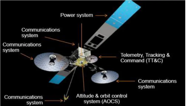
Fig. Communication Satellite
The applications being discussed include: 1. Cartography
2. Monitoring agriculture and forestry 3. Oceanography.
4. Ice Reconnaissance.
5. Monitoring oil pollution and air pollution. 6. Snow melt.
7. Mineral and oil exploration.
Cartography
One of the early applications for earth resource’s imagery has been in cartography i.e.
Monitoring Agriculture and Forestry
Satellite imagery has been quite successfully used for better and optimum crop and forestry management. Remote sensing data from the earth observation satellite in used for several applications such as crop identification , agriculture crop acreage and field estimation, drought monitoring and assessment, flood mapping, land use and land cover mapping, wasteland management , forest resources survey and management.
Satellite data has been shown clear advantage in estimating the volume of timber across a large area of forests. When forests are being cut, it has been possible to monitor this and if necessary to recommended changes in the cutting pattern in the best interest to observation.
Oceanography
Satellite data can be used to determine sea conditions such as Sea surface temperature, Wind direction, Local air temperature and Moisture content etc. Satellite have also been used to make picture of ocean waves , ice fields , ice bergs, ice leads and sea conditions along the coastal lines.
Ice Reconnaissance
Remote sensing satellite data can be used to advantage in forecasting behavior of ice bergs which is very crucial to navigation of ships in cold waters. Navigation of ships in these cold waters depends upon the knowledge of the properties, distribution, variability and behavior of ice bergs.
Monitoring oil pollution, Air Pollution
Satellites can be very effectively used for monitoring oil slicks in the sea. On the contrary, the oil slicks can be spotted very effectively by satellites on global scale except in the places of persistent low clouds.
Snow Melts
Routine photography of snow covered ground and mountains and monitoring of snow cover characteristics such as cover area, thickness, density etc. to make predictions of snow melt can be effectively, speedily and economically performed by satellites. Accurate prediction of snowmelt are important for optimum water management for power generation, irrigation, controlling flood water etc.
Oil and Mineral Exploration
Satellite data can be used for oil and mineral exploration. The data can be used by geologists to see earth’s interlocking features including large folds and ruptures which give clues to mineral deposits. Trans-current faults as indicated by satellite data can be used to male searches from unknown deposits of oil.
Satellite for Weather Forecast
Weather satellites equipped with highly sophisticated instrumentation provide information on cloud formation cloud type and position, extent and intensity of frontal depression thunderstorms, hurricanes, sea breeze circulation, typhoons and so on and so forth. The accuracy of a weather forecast depends largely on the quantity and quality of observational data from the surface of the earth and surrounding atmosphere.
Satellites for Scientific Studies
Satellites orbiting the planet earth at relatively lower altitudes (typically several hundreds of kilometers) have been and are being used to carry out a variety of scientific experimental studies including studying the characteristics of upper region of atmosphere, probing other planets and stars and so on.
Satellites for Military Applications
Right from the beginning, satellites have had important military roles to play both during war time as well as peace time.
Some of the more commonly heard military satellite applications include: 1. Reconnaissance and Intelligence gathering functions
2. Command and Communications
3. Navigation satellites 4. Early warning satellites 5. Meteorological functions 6. Nuclear detection
1. Reconnaissance and Intelligence gathering functions
The most widely known types of military satellites are those used to verify the extent and composition of military forces. One of the most important role of reconnaissance and intelligence gathering satellites is the verification of the agreed limitations of strategic arms and the monitoring of new military developments.
2. Command and Communications
The reconnaissance and intelligence gathering functions though very important represent however a very small fraction of the true scope and diversity of the capabilities of the military satellites. Command and communications is one such application. The satellites today meant for the purpose can provide instant communication between the operational forces and their national command authorities irrespective of the distance or time of the day.
3. Navigation Satellites
4. Early Warning Satellites
Early warning satellite development was basically aimed at providing an advance warning to the owners of a missile attack.
5. Meteorological Functions
Use of satellite data for accurate weather forecast has been one of the earlier benefits of the space programme. The weather satellites not only provide long range forecast for military planners, they also play a key role in reconnaissance satellites.
6. Nuclear Detection
The idea of nuclear detection using satellites perhaps originated in U.S.A. while finding ways to police a nuclear test ban treaty. The solution came in the form of Vela Satellite which had the capability of detection a nuclear explosion at the distance of Venus or Mars and report its yield and other characteristics.
Global Positioning System
GPS, was initially developed to meet the navigational requirements of the Armed Forces, it has found a wide use and acceptance for navigational requirements of a large segment of the commercial market.
Global Positioning System (GPS) is basically a Radio Based navigation system that gives you three dimensional coverage of the earth 24 hours a day, 365 days an year in all weather conditions.
Constituents of a GPS System
A typical GPS system has three components namely: 1. Space Segment, 2. Control Segment and, 3. User Segment
1. Space Segment
The Spaces Segment of the Global Positioning System is a constellation of a total of 24 satellites operated by the US Department of Defence,
Each of the satellites emits synchronous time signals at regular intervals. These signals can be detected the anyone in possession of a GPS receiver. The receiver identifies the transmitting satellites by the received signals and thus determine the satellite’s known position in space.
2. Control Segment
3. User Segment
The User Segment consists of all earth – based GPS receivers including those for civilian and military use.
GPS Positioning Types
There are two types of position determination. These are:
1. Absolute Positioning
This mode of positioning is also known as Stand-alone GPS. This mode relies upon a single receiver station in this case, ranging is carried out strictly between the satellite and the receiver station without taking any assistance from any ground based reference station.
2. Differential Positioning
Differential GPS relies upon an established reference location .
Precise and Standard Positioning Systems
The current series of GPS satellites broadcast data using two distinct signals, one for Standard Positioning system (SPS) at L1 frequency (1547.24 MHz) and the other for Precise Positioning System at L2 frequency 1227.60 MHz).
Remote Sensing
Remote Sensing is the acquisition of information about an object or phenomenon without making physical contact with the object and thus in contrast to on-site observation. Remote Sensing is used in numerous fields, including geography, land surveying and most Earth Science disciplines (for example, hydrology, ecology1, oceanography, glaciology,
geology); it also has military, intelligence , commercial, economic , planning and humanitarian applications.
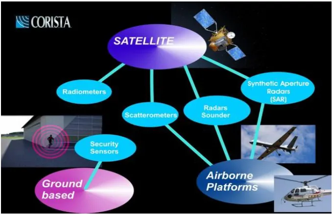
In current usage, the term “remote sensing” generally refers to the use of satellite- or aircraft-based senor technologies to detect and classify objects on Earth, including on the surface and in the atmosphere and oceans, based on pagated signals (e.g. electromagnetic radiation) it may be split into “active” remote sensing (i.e. when a signal is emitted by a satellite or aircraft and its reflection by the object is detected by the sensor) and “passive” remote sensing (i.e., when the reflection of sunlight is detected by the sensor)2,3,4,5.
Remote sensing makes it possible to collect data of dangerous or inaccessible areas. Remote sensing application include monitoring deforestation in areas such as the Amazon in, glacial features in Arctic and Antarctic regions, and depth sounding of coastal and ocean depths. Military connection during the cold War made use of stand-off collection of data about dangerous border areas. Remote sensing also replace costly and slow data collection on the ground, ensuring in the process that areas or objects are not disturbed.
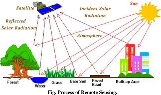
Fig. Process of Remote Sensing.
Orbital platforms collect and transmit data from different parts of the electromagnetic spectrum, which in conjunction with larger scale aerial or ground-based sensing and analysis, provides researchers with enough information to monitor trends such as EL Nino and other natural long and short term phenomena. Other uses include different areas of the earth sciences such as natural resource management, agricultural fields such as land usage and conservation,6,7
and national security and overhead, ground- based and stand-off collection on border areas.8
Application of remote sensing
Conventional radar is mostly associated with aerial traffic control, early warning and certain large scale meteorological data. Doppler radar is used by local law enforcements monitoring of speed limits and in enhanced meteorological collection such as wind speed and direction within weather systems in addition to precipitation location and intensity. Other types of active collection includes plasmas in the ionosphere. Interferometric synthetic aperture is used to produce precise digital elevation models of large scale terrain (See RADARSAT, TerraSAR-X, Magellan).
Laser and radar altimeters on satellites have provided a wide range of data. By measuring the bulges of water caused by gravity, they map features on the seafloor to a resolution of a mile or so. By measuring the height and wavelength of ocean waves, the altimeters measure wind speeds and direction, and surface ocean currents and directions.
Ultrasound (acoustic) and radar tide gauges measure sea level, tides and wave direction in coastal and offshore tide gauges.
Light detection and ranging (LIDAR) is well known in examples of weapon ranging, laser illuminated homing of projectiles. LIDAR is used to detect and measure the concentration of various chemicals in the atmosphere while airborne LIADR can be used to measure height of objects and features on the ground more accurately than with radar technology. Vegetation remote sensing is a principal application of LIDAR.
Radiometers and photometers are the most common instrument in use collecting reflected and emitted radiation in a wide range. Of frequencies. The most common are visible and infrared sensors. Followed by microwave, gamma ray and rarely ultraviolet they may also be used to detect the emission spectra of various chemicals, providing data on chemical concentration in the atmosphere.
Stereographic pairs of aerial photographs have often been in used to make topographic maps by imagery and terrain analysts in traffic ability and highway departments for potential routes, in addition to modeling terrestrial habitat features. (9) (10) (11)
Simultaneous multi-spectral platforms such as Landsat have been in use since the 1970s. these thematic mappers take images in multiple wavelengths of electro-magnetic radiation (multi-spectral) and are usually found on Earth observation satellites, including (for example) the Landsat program or the LKONOS satellite. Maps of land cover and land use from thematic mapping can be used to prospect for minerals, detect or monitor land usage, detect invasive vegetation, deforestation, and examine the health of indigenous plants and crops, including entire farming regions or forests. (4) Landsat images are used by regulatory
agencies such as KYDOW to indicate water quality parameters including secchi depth, chlorophyll a density and total phosphorus content. Weather satellites are used in meteorology and climatology.
Within the scope of the combat against desertification, factors, to support decision-makers in defining relevant measures of environmental management, and to assess their impacts.12
Geodetic
Geodetic remote sensing can be gravimetric or geometric. Overhead gravity data collection was first used in aerial submarine detection. This data revealed minute perturbations in the Earth ‘s gravitational field that may be sued to determine changes in the mass distribution of the Earth which in turn may be used for geophysical studies. As in GRACE (satellite). Geometric remote sensing includes position and deformation imaging using INSAR, LIDAR, etc.13
Acoustic and near-acoustic
Sonar: passive sonar listening for the sound made by another object (a vessel, a whale etc.): active sonar emitting pulse of sounds and listening for echoes, used for detecting, ranging and measurements of underwater objects and terrain.
Seismograms taken at different locations can locate and measure earthquakes (after they occur) by comparing the relative intensity and precise timings.
Ultrasound: ultrasound sensors, that emit high frequency pulses and listening for echoes, used for detecting water waves and water level, as in tide gauges or for towing thanks.
To coordinate a series of large-scale observations, most sensing systems depend on the following platform location and the orientation of the sensor high-end instruments now often use positional information from satellite navigation systems. The rotation and orientation is often provided within a degree or two with electronic compasses. Can measure not just azimuth (i.e. degrees to magnetic north), but also altitude (degrees above the horizon), since the magnetic field cures into the Earth at different latitudes. More exact orientation require gyroscopic- aided orientation, periodically realigned by different methods including navigation from stars or known benchmarks.
Data processing
Generally speaking remote sensing work on the principle of the inverse problem. While the object or phenomenon of interest (the state) may not be directly measured, there exists some other variable that can be detected and measured (the observation) which may be related to the object of interest through a calculation the common analogy given to describe this is trying to determine the type of animal from its, footprints. For example while it is impossible to directly measure temperatures in the upper atmosphere, it possible to measure the spectral emissions from a known chemical species (such as carbon dioxide) in that region the frequency of the emissions may then be related via thermodynamics to the temperature in that region.
Spatial resolution
The size of a pixel that is recorded in a raster image- typically pixels may correspond to square areas ranging in side length from 1 to 1,000 meters. (3.3to 3,280.8ft)
Spectral resolution
The wavelength of the different frequency bands recorded- usually, this is related to the number of frequency bands recorded by the platform current Landsat collection is that of seven bands, including several in the infra-red spectrum ranging from a spectral resolution of 0.07 to 2.1 𝜇m. The hyperion sensor on Earth observing-1 resolves 220 bands from 0.4to 2.5
𝜇m. With a spectral resolution of 0.10 to 0.11 𝜇m per band.
Radiometric resolution
The number of different intensities of radiation the senor is able to distinguish. Typically, this ranges from 8 to 14 bits, corresponding to 256 levels of the gray scale and up to 16,384 intensities or “shades” of colour, ion each band. It also depends on the instrument noise.
Temporal resolution
The frequency of flyovers by the satellite or plane and is only relevant in time- series studies or those requiring an averaged or mosaic image as in deforesting monitoring. This was first used by the intelligence community where repeated coverage revealed changes in infrastructure. The deployment of units or the modification/introduction of equipment. Cloud cover over a given area or object makes it necessary to repeat the collection of said location.
In order to create sensor-based maps, most remote sensing systems expect to extrapolate sensor data in relation to a reference points on the ground. This depends on the type of sensor used. For example in conventional photographs distance are accurate in the center of the image. With the distortions of measurement increasing the farther you get the center. Another factor is that of the platen against which the film is pressed can cause severe errors when photographs are used to measure ground distances. The step in which this problem is resolved is called georeferencing and involves computer-aided matching of points in the image (typically 30 or more points per image) which is extrapolated with the use of an established benchmark, “warping the image to produce accurate spatial data. As of early 1990s, most satellite image are sold fully georeferenced.
In addition, image may need to be radiometrically and atmospherically corrected.
Radiometric correction
Allows to avoid radiometric errors and distortions. The illumination of object on the Earth surface is uneven because of different properties of the relief this factor is taken into account in the method of radiometric distortion correction.14 Radiometric correction given a
Topographic correction (also called terrain correction)
In rugged mountains as a result of terrain the effective illumination of pixels varies considerably. In a remote sensing image the pixel on shady slope receives weak illumination and has a low radiance value, in contrast the pixel on the sunny slope receives strong illumination and has a high radiance value. For the same object the pixel radiance value on the shady will be different from that on the sunny slope. Additionally, different objects may have similar radiance values. These ambiguities seriously affected remote sensing image information extraction accuracy in mountainous areas. It became the main obstacle to further application of remote sensing image the purpose of topographic correction is to eliminate this effect, recovering the true reflectivity or radiance of objects in horizontal conditions. It the premise of quantitative remote sensing application.
Atmospheric correction
Elimination of atmospheric haze by rescaling each frequency band so that its minimum value (usually realized in water bodies) corresponds to a pixel value of 0. The digitizing of data also makes it possible to manipulate the data by changing gray-scale values.
Interpretation is the critical process of making sense of the data. The first application was that of aerial photographic collection which used the following process; spatial measurement through the use of a light table in both conventional single or stereographic coverage, added skills such as the use of photogrammetry the use of photo mosaics, repeat coverage making use of objects; known dimensions in order to detect modifications .image analysis is the recently developed automated computer-aided application which is in increasing use.
Object-Based image analysis (OBLA) is a sub-discipline of GLScience devoted to partitioning remote sensing (RS) imagery into meaningful image –objects, and assessing their characteristics through spatial, spectral and temporal scale.
Old data from remote sensing is often valuable because fit may provide the only long- term data for a large extent of geography at the same time the data is often complex to interpret and bulky to store modern systems tend to the data digitally often with lossless compression the difficulty with this approach is that the data is fragile, the format may be archaic, and the data may easy to falsify. One of the best systems for archiving data series is as computer – generated machine- readable ultra fiche, usually in type fonts such as OCR-B, or as digitized half-tone images. Ultra fiches survive well in standard libraries, with lifetimes of several centuries. They can be created, copied filed and retrieved by automated systems. They are about as compact as archival magnetic media, and yet can be read by human beings with minimal, standardized equipment.
CONCLUSION
REFERENCES
1. (Edited ) Anthropological Method for Communication Research, New Delhi (1985). 2. Price, K.M. Lazar, Y., Technology to Enable Low Cost Satellite Communication, AIAA
int. Conf. on Communication Satellite Systems, pp. 1065- 1075, Feb. 25-29, 16th,
Washington, D.C (1996).
3. Giacomo Capizzi, Grazia Lo Scioto, Marci Wozniak, Roberts Damasevicius: A Based System for Automated Oil Spill Detection by Satellite Remote Sensing ,(ICAISC)(2): 613- 623 (2016).
4. Schowengerdt, Robert A. Remote Sensing: models and method for image processing (https//books.google.com /books ?id= KQXNadh0x- IC& PG= PA2)(3ed ed.). Academic Press. p. 2. ISBN 978-0-12-369407-2. Schott, John Robert (2007). Remote sensing: the image chain approach
(https://books.google.com/books?id=uoXvgwOzAKQC&pg=PT20) (2nd ed.). Oxford
University Press.p.1.ISBN 978-0-19-517817-3.
5. Guo, Huadong; Huang, Qingni; Li, Xinwu; Sun, Zhongchang, Zhang, Ying. “Spatiotemporal analysis of urban environment based on the vegetation –impervious surface-soil model” (2013).
(http//remotesensing.spiedigitallibrary.org/article.aspx?articleid=1783836) (Full text article available). Journal of Applied Remote Sensing. 8;084597. Bibcode; 2014 JARS……8.4597G(http://adsbs.harvard.edu/abs/2014JARS....8.4597G).doi:10.1117/1.J RS.8.084597(https:doi.org/10.1117%2FI.JRS.8.084597).