THE NATURE AND FUNCTION OF THE MANOR COURT 1350-1700
submitted by Mary Saaler
for the degree of Ph. D.
UNIVERSITY COLLEGE LONDON
January 1994
ProQuest Number: 10105720
All rights reserved
INFORMATION TO ALL USERS
The quality of this reproduction is dependent upon the quality of the copy submitted.
In the unlikely event that the author did not send a complete manuscript and there are missing pages, these will be noted. Also, if material had to be removed,
a note will indicate the deletion.
uest.
ProQuest 10105720
Published by ProQuest LLC(2016). Copyright of the Dissertation is held by the Author.
All rights reserved.
This work is protected against unauthorized copying under Title 17, United States Code. Microform Edition © ProQuest LLC.
ProQuest LLC
789 East Eisenhower Parkway P.O. Box 1346
Abstract
The aim of the study Is to analyse the records of three manor courts over a relatively long time-scale, with the object of identifying the changes which occurred in the nature and function of the manor court from 1350 until 1700. The principal source material consists of previously untranslated and untranscribed records of the view of frankpledge, or court leet, and court baron of the Surrey manors of Carshalton, Farleigh and Merstham, which lie 16-26 km. from London. Since the manors differ
in their historical and geographical background, we can use this material to make comparisons and to identify broader regional trends.
Following a discussion of the history of the manors and the extent and compilation of the records, with the aid of a computer data-base, I have examined the functions of the view. These are defined as a) residence, b) supervision of trade, c) minor criminal offences, d) management of the environment and e) the procedures of payment, distraint and dispute settlement. This is followed by an assessment of the roles of officials,
identified as tithingmen, ale tasters, constables and jurors. This leads to a discussion of the influence of external factors, such as the quarter sessions and parliamentary legislation.
-I have similarly analysed the records of the court baron to show changes in property-holding, the role of the jurors and in procedures, such as dispute settlement, use of pledges and distraint.
By making this investigation, we can see the reactions of the community to social and economic factors as it developed from a medieval to an early modern society.
TABLE OF CONTENTS page
GENERAL INTRODUCTION 8
1. HISTORICAL BACKGROUND 13
CARSHALTON FARLEIGH
MERSTHAM AND ALBURY
2. RECORDS 32
CARSHALTON FARLEIGH
MERSTHAM AND ALBURY
3. VIEW OF FRANKPLEDGE 42
CARSHALTON
I. Jurisdiction of the view terri tory
people
II. Work of the view 1) residence a) enrolment b) default
c) keeping the watch
2) supervision of trade and traders a) brewers and sellers of ale
b) bakers and sellers of bread c) millers
d) fishmongers
3) minor criminal offences a) assault
b) theft
c) hue and cry
d) disturbances of the peace 4) management of the environment a) water
b) enclosures c) roads
d) bridges e) orders
III. Procedures at the view 1) payments
a) residence
b) supervision of trade and traders c) minor criminal offences
d) management of the environment 2) distraint
3) settlement of disputes and use of pledges
MERSTHAM page I. Jurisdiction of the view
II. Work of the view 1) residence
a) enrolment and default b) common fine
2) supervision of trade and traders 3) minor criminal offences
4) management of the environment III. Procedures at the view
1) payments 2) distraint
3) settlement of disputes and use of pledges IV. Officials of the view
1) tithingmen 2) ale tasters 3) constables
4) Jurors of the view
4. WHY DID THE VIEW OF FRANKPLEDGE
DISAPPEAR? 263
5. COURT BARON 274
I . Work of the court baron FARLEIGH
CARSHALTON MERSTHAM ALBURY
I I . Procedures at the court baron 1) enquiries
2) distraint
3) settlement of disputes and business between tenants
4) pledges
III. Jurors of the court baron CARSHALTON
FARLEIGH MERSTHAM ALBURY
6. ADAPTATION AT THE COURT BARON 437 7. GENERAL CONCLUSIONS:
THE PROCESSES OF CHANGE 452
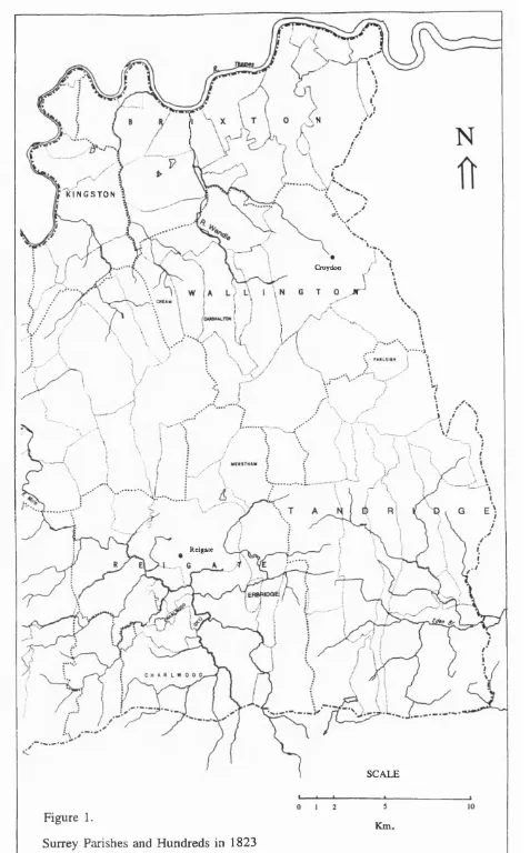
-FIGURES page 1. Surrey parishes and hundreds in 1832. 12 TABLES
1. Number of individuals mentioned in each
50 year period. 53
2. Total number of residents unsworn
or withdrawn. 62
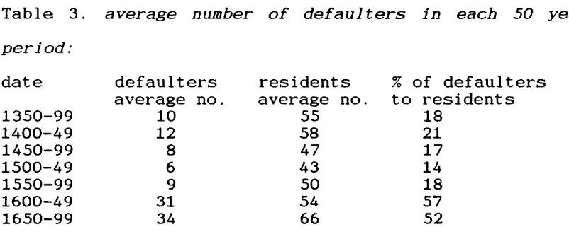
3. Average number of defaulters in each
50 year period. 64
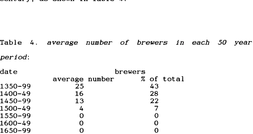
4. Average number of brewers in each
50 year period. 77
5. Number of individuals charged with
offences in each 50 year period. 94 6. Number of fines in each 50 year period. 163
7. Average fines. 163
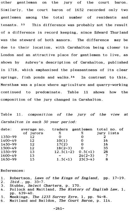
8. Number of penalties in each 50 year period. 177 9. Use of distraint in each 50 year period. 181 10. Number of brewers in each 50 year period. 221 11. Composition of the jury of the view at
Carshalton in each 50 year period. 261 12. Property transactions in each
50 year period. 278
13. Landholdings in acres (excluding woodland). 282 14. Inheritance transactions in each
50 year period. 287
15. New tenancies in each 50 year period. 287
page 16. Proportions of free and customary tenants
in Farleigh. 292
17. Distraint orders in Carshalton. 351 18. Distraint orders in F a rleigh. 357 19. Distraint orders in M e rstham. 359 20. Distraint orders in A 1b u r y . 361 21 . Frequency of distraint orders. 361 22. Business between tenants
In Carshalton 1350-99. 367
23. Business between tenants
in Farleigh 1400-99. 377
24. Business between tenants
in Merstham 1350-99. 382
25. Business between tenants
in Merstham 1400-99. 384
26. Proport ion of jurors to tenants. 417 27. Proport ion of defaulters to tenants. 431 28. Proport ion of tenants present at meetings. 433
-GENERAL INTRODUCTION
The aim of this study is to examine the degree of change in the nature and function of the manor court in three Surrey manors over a period of 350 years. This work is based on the local records of Surrey manors; it does not produce a history of Surrey, but it provides an analysis of detail which allows us to compare changes in the social process in an area of Surrey in a way which may be may be relevant potentially to areas outside Surrey.
The individual manors are small enough for us to examine the history of each one and, when studied together, they describe patterns of change in the eastern part of Surrey. The manors of Carshalton, Farleigh and Merstham were chosen for this work principally because of the quantity of records available for each manor over such a wide time-scale, providing plenty of material for a comprehensive analysis. Because they also provide a variety of geographical environments, we can study the effect of location on the work of the manor courts.
The purpose of this enquiry is to assess the amount of change by examining closely the procedures of the manor courts and the actions of the people mentioned in the records. In order to examine the records objectively, I have compiled a computer data-base of names. Since the
-compilers of the original records used names as a way of identifying individuals, I have followed a similar procedure. Individuals have been identified by name, date and manor, with further information about occupation, office-holding, property and inheritance. Where people held the same names, the compilers of the original records usually included additional information and defined them as 'senior’ or 'junior', or by occupation or property. With the name as an identifier, all the events associated with that name have been listed. By using these procedures, we can accumulate information about ordinary people whose lives would otherwise be unnoticed.
There is no simple rule for the spelling of names; where modern standard spelling exists for names like Bolton, Henley and Miller, I have used the modern form. With some names there are so many variations that it is difficult to find a modern standard form and I have used the form which is most common in the records; for example, Dylcok, Fromond and Leycester. For the place- names I have used the spellings which are used at present, if the places can be identified. For places which cannot be identified, I have used the spelling which is most commonly used in the records.
As a way of dealing with such a large amount of information, I have separated the work of the manor court
-into the two elements of a) the view of frankpledge, or court leet, and b) the court baron. The two elements had separate origins and had different functions, since the view was concerned with residents and the court with tenants. However, in practice, the two meetings frequently involved the same people. In some cases, the records of the two meetings were kept distinct and separate throughout the period, in other cases, the distinction was less clear. There is no surviving view of frankpledge for Farleigh, but the records of the court baron are very comprehensive.
I have looked at the roles of local officials to examine the degree of change. The roles of the jurors of the view and the court baron have caused particular problems. The Assize of Clarendon clearly defined the roles of juries in royal courts as a) juries of presentment and b) trial juries, with a clear distinction between the two roles. 1 However, there is no evidence of such a distinction at the manor court where local jurors presented cases, held enquiries, and made decisions. In the absence of conflicting evidence, we have to assume that a group of jurors fulfilled all these roles. Putnam made a similar observation about the juries of the quarter sessions when she stated that the phrase item
présentant covered a number of different, undefined
pro c e d u r e s . 2
There have been many studies of the manor court ; Maitland, in his late nineteenth-century studies of medieval manorial records, laid the foundations for twentieth-century interpretations of the manorial system. However, with a few exceptions, most later studies of the development of the manor court have concentrated on the medieval or early modern period and lacked investigation into long-term change.
References :
1. Stubbs, Select Charters, pp. 170-3. 2. Putnam, Proceedings Before JPs, p. 43.
\ N
K I N G S T O N
Croydon
JT
Rcigate
SCALE
Figure 1.
Surrey Parishes and Hundreds in 1823
Km.
1. HISTORICAL BACKGROUND
CARSHALTON
The parish of Carshalton lies on the north side of the North Downs, extending about 2km. from east to west and about 8km. from north to south, covering an area of almost 3000 acres. Because we have no estate maps for the manor of Carshalton, there is no evidence to show whether the boundaries of parish and manor coincided. There were clearly changes in the composition of the manor, as five pre-conquest manors were amalgamated into one by the time of Domesday and sometimes the manor included holdings in the adjoining manors of Morden, Sutton and Wallington. However, in spite of such changes, there was probably a rough correlation between the extent of manor and parish. i
Cemeteries along the North Downs, dating from the fifth and sixth centuries, are evidence for settlement in the early Anglo-Saxon period, while the charters of Chertsey Abbey refer to a grant of ten hides in Carshalton to the abbey, which was confirmed by A t h e 1stan in the early tenth century. 2
The Domesday survey refers to a water mill in Carshalton, while the earliest forms of the place-name,
-which appeared as Auueltone in the seventh-century charter and in Domesday as Aultone, contained references to water. ^ The study of Surrey place-names suggests that it means ’a farm by the spring-head', with the word 'cress' being added at a later date, implying that Carshalton was once the site of a water-cress farm. Confirmation of watercress-growing is found in a thirteenth-century grant of a messuage in Carshalton 'cum kersenaria' - 'with a watercress bed'; furthermore, the Domesday reference to a mill shows that exploitation of the natural resources was already under way in the eleventh century. ^ The medieval village grew up close to the water supply and spread east-west along the highway running between Croydon and Sutton. The Victoria
County History refers to several strong springs which
join to form a large tributary of the River Wandle, with the united stream forming the eastern boundary of Carshalton; at the present day the springs still supply water to large, clear ponds in the village itself, giving a total area of about 22 acres of water. ^
The value of the water as a source of power for mills made the area attractive to religious establishments in Surrey, particularly Chertsey Abbey, Merton Priory and the Priory of St Mary Overy, later known as Southwark Priory, all of which held land and mills in Carshalton at
various times until the early years of the sixteenth century. ^
At the time of Domesday, the manor of Carshalton was held by Geoffrey de Mandeville, who also held two other Surrey manors, Clapham and Wanborough. ^ The overlordship of the manor descended through the Mandevilles to the Bohuns who married into the royal family and, by 1399, it had passed to the crown. ®
Although we cannot be certain about the boundaries of the manor of Carshalton, we can see that, by the time of Domesday, changes had already taken place in its structure, since Mandeville had granted one part of it to his son-in-law, Geoffrey de Boulogne. This part of the manor, which formed the chief part and was called Carshalton, passed to Geoffrey's grandson, Faramus de Boulogne, whose daughter, Sybil, married Ingram de Fiennes. The Fiennes held this share of the manor until the 1280s when William de Fiennes granted it to Sir William Ambesas. Manning and Bray in The History of Surrey refer to various documents of the reign of Edward III concerning this portion which show that, by 1374, it was held by Nicholas Carew who also acquired the adjoining manor of Beddington. ® The holding continued with the Carews, or their relations, passing through the female line. John Iwardby had married Sanctia, one of
-the daughters of Nicholas Carew and, In this way, acquired the lordship of Carshalton. He was a JP and became a knight of the bath in 1501. He and his wife lived at Fitznells in Ewell, about 5km. to the west of Carshalton, which provided Iwardby with a ’pleasant manor-house and groves and a paddock for his h o r s e s ’. When he died in 1523, the manor passed to his daughter Joan who married John St John. The St Johns retained the manor until 1580, when it passed to Richard Burton, whose family kept part of the manor but sold a share of it to Walter Cole in 1590. i ° The two parts were bought and sold numerous times, often by London lawyers, until Sir William S c a w e n , a wealthy merchant and a governor of the Bank of England, re-united both parts of the manor by buying one part in 1696 and the other in 1713. n
The other portion of the Mandeville manor had a similar history and was held by a series of undertenants who did fealty at the manor court for their tenements. Among these was the Coleville family which, in the thirteenth century, obtained the grant of a weekly market on a Tuesday and an annual fair for three days at the beginning of September. Manning and Bray considered that this share of Carshalton was probably the manor or estate later known as Stonecourt, which was held by the Gaynesford family from about the mid-fifteenth century until the mid-sixteenth century. This part was also
subdivided and sold numerous times until it was acquired by Thomas Scawen in 1729. A third estate, or so-called manor, the manor of Kinnersley, which consisted of land in Carshalton and the adjoining manors of Morden, Sutton and Wallington, passed through various hands and was also acquired by the Scawens in 1696. 12
From these transactions we can see that the manorial history of Carshalton was a process of fragmentation and subdivision over about 650 years, followed by eventual re-unification under the Scawens in 1729. The high intensity of transactions concerning the manor may have resulted from its proximity to London, which made it an attractive and convenient place for country residence by wealthy Londoners. Meekings, in his discussion of the value of the hearth tax records of the 1660s as a social document, stressed the uneven distribution of population through the county of Surrey, stating that the influence of London was particularly obvious in the large villages north of the North Downs, like Carshalton and Clapham,
'where there were many houses of the sort which came to be called villas in the next c e n t u r y ’, and he compared these with the scanty population of the settlements on the eastern North Downs, such as Farleigh and Chelsham. 13
-resources
As well as being an attractive place for residence, Carshalton had other aspects which encouraged settlement, principally a variety of soils and a good water supply. The earliest available statistics, compiled in 1801, provide evidence for the size, population and agriculture of Carshalton. In an area of almost 3000 acres there were 1449 inhabitants, making it the most densely inhabited area in this study. The crop returns for the same year show that 436 acres were used for wheat , 242 acres for barley, 275 acres for oats and almost 200 acres for a mixture of potatoes, peas, beans, rape, turnips and rye, leaving the largest element of about 1800 acres for other uses. i * While it is impossible to be specific about the 'other uses', there were areas of pasture and common grazing land, some of which were used for horse- racing; the southern area of Carshalton included part of what is now called Epsom Downs. In addition, the fertility of the soil made it suitable for gardens and orchards. John Evelyn, writing in the seventeenth century, described Carshalton as 'full planted with Walnuts and Chery trees, which afford a considerable rent'. i ^ Fuller, too, commented on the walnuts and added that the fine timber was used for both furniture and gun stocks. ^ ^ The emphasis on cherries and walnuts may explain the references in the records of the
-court baron to the orchards and gardens which adjoined some of the houses.
While Evelyn and Fuller mentioned the orchards, John Aubrey referred to the water supply in Carshalton, commenting on its many springs and fish ponds.i? This water supply, usually known as the River Wandle, also provided the basis for industrial development and employment for the local population. Evidence for the intensive industrial use of the river can be found in a report of a royal commission in 1609 which proposed to divert a tenth of the flow to supply water to London through a system of canals, tunnels and pipes. At that time there were 24 corn mills on the Wandle and in Carshalton in particular there were three corn mills, two fulling mills and a gunpowder mill. Because of this heavy usage, millers had difficulty in maintaining a head of water and the plan to divert some of it to London was abandoned. One of the arguments put forward against the proposal provides evidence for close trading links with London - the millers declared that since the Wandle never froze, they could continue to supply London with corn even when the Thames was frozen over. So, the water supply in Carshalton was undiminished and the mills were used to produce gunpowder, sheet copper, linseed oil, drugs, snuff, paper and leather during the seventeenth and eighteenth centuries,
-References :
1. Blair, Early Medieval Surrey, pp. 43-4. 2. Kemble, Codex Diplomat i eus, 5, pp. 19-21; 2,
pp. 193-4. Blair, Early Medieval Surrey, p. 7. n.l9 Blair considers that, while the authenticity of the Chertsey Abbey charters has been challenged, 'the core of the text' may be regarded as reliable.
3. Morris, Domesday Surrey, 25.2.
4. Cover, Mawer and Stenton, Place-Names of Surrey, p. 41. Morris, Domesday Surrey, 25.2.
5. VCH. Surrey, 4, pp. 178-9. 6. Ibid,
7. Morr i s , Domesday Surrey, 25.2. 8 . V C H . Surrey, 4 , p . 181.
10. Meekings and Shearman, FitznelIs Cartulary pp. cxi-ii; cxxxiii.
11. Manning and Bray, History of Surrey, 2, pp. 506-10. 12. Ibid., pp. 511-12.
13. Meekings, Surrey Hearth Tax 1664, p. cxxxvii.
14. VCH. Surrey, 2, p. 451. Parton, '1801 Crop Returns for Surrey', p. 121.
15. de Beer, The Diary of John Evelyn, 4, p. 16. 16. Freeman, Thomas Fuller: The Worthies of England,
p. 542.
17. Aubrey, The Natural History and Antiquities of Surrey, 2, p. 114.
18. VCH. Surrey, 4, p. 254.
FARLEIGH
The manor of Farleigh is situated on the North Downs about 24km. to the south of London; an estate map of 1768 shows that it was a relatively small manor, covering about 1051 acres. The map also shows that the boundaries of manor and parish coincided at that date - a situation which existed until the later years of the twentieth century when the parish was amalgamated with Chelsham and Warlingham. i
The first documented reference to Farleigh is found in a ninth-century charter when ealdorman Alfred, described as dux, granted land in Fearnlega to a certain Eadred in return for the payment of 30 measures of corn to the monks of Rochester. 2 At the time of Domesday the manor, like many others in Kent and Surrey, was held in overlordship by Richard de Clare. Farleigh, together with the adjoining manor of Chelsham, was held of the Clares by Robert Wat vile, who was a major tenant of the Clares. ^ The Clare overlordship lasted until the death of Gilbert de Clare in 1314, when it passed by marriage to the Despensers who retained it until 1375 when the overlordship lapsed. The Watviles continued to hold the lordship of Farleigh but , by the middle of the thirteenth century, William Watvile had granted his manors of Farleigh and Malden to Walter de Merton, chancellor to Henry III, * (Malden lies in Surrey about 18km. to the north west of Farleigh). In 1264 Gilbert de Clare gave formal approval to the transfer, allowing the revenues from the two manors to be used to support an establishment in Malden, run by a warden and priests. It was their responsibility to provide income from the manors of Farleigh and Malden to pay for the education of 20 poor scholars at a university. ^
It was not until 1274 that this establishment moved to Oxford after Walter de Merton had acquired a building
there which was suitable for scholars. He then combined the two elements of teaching and administration in one building and called it Merton College. He also laid down the statutes for governing his foundation. He later acquired other manors to provide revenue for his college,
including a third Surrey manor, called T horncroft, at Leatherhead.
Following the instructions laid down in the founder's statutes, the Merton manors were under the direct control of a warden, and he, or some of his officials, were required to visit the manors at regular intervals. Evidence for their visits is found in the account rolls of the various manors which listed the expenses of the warden and his officials. On their visits to Farleigh, they stayed at the manor-house there. In compliance with the same statutes, the local official, or serviens, rendered his accounts annually to the bursars and fellows of the college. The affairs of the tenants were managed at the court baron where a steward appointed by the college presided over the meetings. Evidence from the thirteenth-century rolls shows that at that date the same steward was responsible for all three Surrey manors. ^ The lordship of the manor has remained unchanged since the thirteenth century and, in the 1990s, the college is still the largest landholder in Farleigh.
-The earliest available population numbers for Farleigh were given in 1767 by the Rev. Joseph Kilner who, after serving as bursar at Merton College, retired to Farleigh and became rector there. He described his parish as 'very small and retired', containing about 20 families consisting of 94 individuals, 18 of whom were in the manor-house. ^ Kilner's population figure of 94 individuals is corroborated by the census returns of 1801 which recorded 95 inhabitants - a population density which remains the same in the 1990s. ®
resources
Kilner commented that the parish covered about 1000 acres, with about 300 acres being planted with corn and about 400 given over to pasture and hay crops. His figures are supported by the crop returns for 1801 which show that at that date 321 acres were used for the production of wheat, oats, barley, turnips, peas and potatoes, with the remaining 700 acres being divided between pasture and woodland. ^ The account of Farleigh given in the Victoria County History in 1912 suggests that, because of its situation on the North Downs, where the chalk is capped with a mixture of brick earth, clay and gravel, the soil is not particularly fertile, with the result that a considerable amount of land was used for woodland. From these post-1700 studies, a general
-picture emerges of a small manor with a low density of population, dependent on a mixed economy of arable, pasture and woodland, continuing the pattern which had been established in the medieval period.
References : 1. MM 4901.
2. VCH. Surrey, 3, pp. 281-2. 3. Morris, Domesday Surrey, 19.8. 4. VCH . Surrey, 3, p . 282.
5. Manning and Bray, History of Surrey, 3, pp. 3-6. 6. Briggs, Surrey Manorial Accounts, pp. xxvii-xxx. 7. Lambert,' Surrey Manors held by Merton College
and Corpus Christi College', pp. 39-41. 8. VCH. Surrey, 4, p. 450.
9. Par t o n , '1801 Crop Returns for Surrey', p. 121. 10. VCH. Surrey, 3, pp. 281-2.
MERSTHAM AND ALBURY
In contrast to Carshalton and Farleigh, the parish of Merstham lies on the southern side of the North Downs, extending for about 3km. from east to west and about 5km, from north to south, occupying about 2000 acres. The earliest reference to Merstham occurs in a charter of Chertsey Abbey of 675 which recorded a grant of 20 hides of land in Merstham to the abbey. i In addition to the Chertsey material , there is a diploma of 947 by which Eadred, king of Wessex, granted 20 hides in Merstham to his minister, Oswig. Because this document included a perambulation of the boundaries of the territory held by
the grant, we can see from a study of the place-names that the boundaries of 947 corresponded roughly to the boundaries of the parish, as defined by the tithe map of the 1840s. 2 This suggests that the boundaries of manor
and parish were virtually the same. The medieval village of Merstham developed in the centre of the parish on the upper greensand at the foot of the chalk escarpment of the downs, close to an abundant spring and on the main highway between the towns of Croydon and Reigate. A grant of weekly market and annual fair was recorded in 1338. 3 Both the Chertsey Abbey charter and the diploma referred to Merstham having woodland pastures outside its boundaries. The diploma allows us to identify these as lying in the parish of Horley at Petridgewood, Great and Little Lake Farms and Thundersfield, an area which lies about 6km. to the south of Merstham.
The records of Canterbury Cathedral show that, in 1018, Archbishop A t h e 1stan granted Merstham to the convent and priory of Christchurch, Canterbury, and by the same grant he also gave the Surrey manors of Cheam and Chariwood to Christchurch. ^ The Domesday survey recorded that the archbishop held Merstham, ’for the clothing of the monks' of Christchurch, and Cheam 'for the supplies of the monks', while Chariwood was not included in the survey. ^
In the later eleventh century, Lanfranc organized a division of the archbishop's property, retaining some for
-himself while granting the manors of Merstham, Charlwood and Cheam to Christchurch, with all three being administered from Merstham. ^ As a result of the organization, the prior of Christchurch was responsible for the practical administration of the Surrey manors. There was a further change in the late thirteenth century. By 1285 the manor of Cheam was divided into the two estates of East and West Cheam, with East Cheam being held by the archbishop and adminstered from his court at Croydon, while West Cheam remained with Christchurch and was administered from Merstham. ^
In contrast to Cheam, the manor of Charlwood lay in the wealden forest, about 13 km. south west of Merstham. As well as providing extensive woodland, Charlwood also contained ironstone. The importance of the iron is shown by a fourteenth-century lease of the manors of Merstham and Charlwood, which reserved the right of iron extraction for the prior and convent of Christchurch. ®
In addition to these two manors, the court at Merstham was responsible for the administration of the tithing of Erbridge from at least 1388 until the 1520s. An estate map of Horley dated 1602 shows the location of Erbridge Street and an area called Erbridge lying close to Great and Little Lake Farms, while place-names in the Merstham records reveal that Erbridge extended northwards from
Thundersfield at least as far as Salfords. This evidence suggests that the tithing of Erbridge represented the woodland pastures which were included in the grant of 947, when they were described as Petridgewood (which lies on the northern side of Salfords), Great and Little Lake Farms and Thundersf ield. ^ The northern boundary of the area defined as Erbridge lay 6km. to the south of Merstham in the wealden forest, where it was criss crossed by tributaries of the River Mole. Much of the forest area was divided up into the woodland pastures of manors which lay to the north, including Merstham and Cheam, an arrangement which led Blair to describe it as
’a b e w i 1dering1 y complex patchwork of outliers'.io
All these manors, together with the tithing of Erbridge, were held by Christchurch until the Dissolution caused the break-up of the Merstham manors. Both Merstham and Charlwood passed to Sir Robert Southwell, Master of the Rolls, who leased out Charlwood, which then ceased to be included in the Merstham records. East and West Cheam were combined into one manor, becoming part of the honour of Hampton Court, and like Charlwood had no further representation at the Merstham court. An estate map shows that Erbridge had become incorporated into the manor of Horley by the early seventeenth century. Merstham itself was held by the Southwells until 1569 and then passed to the Copley family. In 1608 it was
-acquired by John Hedge, whose family retained it until 1678 when it passed to Sir John Southcote. Eventually, in 1788, the manor was purchased by William Jolliffe, whose descendents retained it until the twentieth century. ii
resources
Manning and Bray, writing at the beginning of the nineteenth century, emphasised the contrast between the northern and southern areas of the parish, which was almost equally divided by the chalk escarpment of the downs. They described the northern part, consisting of clay-with-f1i n t s , as difficult for cultivation but ’under skilful husbandry, productive of much excellent c o r n ’, while the southern area contained clay, sand and good agricultural land. They also commented on the meadows which were famous for their excellent hay, stating that ’formerly beasts of great weight were fed h e r e ’, and they noted the absence of woodland. 12
The crop returns for 1801 suggest a similar picture, since they reveal that about half the acreage of Merstham was given over to the production of oats, wheat, barley, potatoes, peas and turnips. This leaves about half the area unaccounted for, but much of this was probably used for grazing, as suggested by Manning and Bray. 1^
-The importance of Merstham, however, lay in its position on the upper greensand, where stone may have been quarried during the pre-conquest period. i* Although Domesday contained no reference to stone quarries in Merstham, the adjoining manor of Chaldon provides the first definite evidence for stone-working in the same rock stratum, as it was assessed for two quarries (due fosse Lapidum^ . ^ ^ The lease of the manors of Merstham and Charlwood made in 1396, which reserved the right to extract iron in Charlwood to the prior and convent of Christchurch, imposed a similar condition in Merstham, where two stone quarries were reserved for the use of the prior and convent. i^ Because the quarries at Merstham were the nearest source of building stone to London, the stone was used extensively there from the middle ages onwards. Its quality as freestone, which has virtually no grain and splits fairly easily in all directions, made it suitable for decorative carving and it was used particularly for royal and ecclesiastical buildings, generally for interior work. In the thirteenth century
it was used for the royal palace at Westminster and in the fourteenth century it was taken to Windsor Castle, St P a u l ’s Cathedral and London Bridge.
In spite of its poor resistance to weathering, the stone was widely used until the twentieth century because of its proximity to London and the ease with which it could
-be worked. From the time of the Industrial Revolution it was also used as a refractory to line furnaces because of
its ability to withstand the effects of heat. After William Jolliffe acquired the manor of Merstham in 1788, he was instrumental in promoting a plateway, known as the Croydon, Merstham and Godstone Iron Railway. This formed a southern extension to the Surrey Iron Railway, which provided a track for horse-drawn waggons. Jol l i f f e ’s aim was to transport building stone and lime from Merstham to London. The extension was opened in 1805 but the venture was not a financial success, chiefly because there was insufficient return traffic; it was
later replaced by railways for steam locomotives. i?
Evidence in the court rolls of Merstham suggests that the quarries lay within the manor and parish of Merstham on an estate or manor of about 400 acres, known as A 1bury. From the beginning of the fourteenth century Albury was held on lease as a separate tenement within Merstham and, by the mid-fourteenth century, it was held by Fulk Horwood, a citzen of London. In about 1472-3 Albury was conveyed to John Elmbridge, whose second wife, Anne, was the daughter of John Prophète. Members of the Prophète family had been concerned with working the stone since at least 1360, when two of them were managing the quarries and were ordered to supply stone and workmen for Windsor Castle. 1® In the early sixteenth century, Albury passed
to John Elmbridge, grandson of John Elmbridge senior, but he died as a child, and it then passed to John's elder sister, Anne, who later married her guardian, John Dannet. In this way. Sir John D a n n e t , of Dannet Hall in Leicestershire and a citizen of London, acquired the estate or manor of Albury. Monuments to the Prophètes, Elmbridges and Dannets in St Katherine's Church at Merstham are evidence of their local involvement in the area. By 1579, the Dannets had transferred the manor to John Southcote, a judge of the queen's bench. The Southcotes also acquired the manor of Merstham in the mid-seventeenth century and, from then on, the two manors were held jointly. i9
Ref e r e n c e s :
1. Kemble, Codex Diplomat i eus, 5, p. 19. 2. Ibid., 2, p. 271.
3. C a l . Charter Dolls, 12 Ed. Ill, p. 445.
4. Hist. Mss. Comm. Report 8, A p p . p t . 1, pp. 323-4. 5. Morr i s , Domesday Surrey, 2.3; 2.2.
6. Hist. Mss. Comm. Report 8, App. p t . 1, pp. 317-18. 7. Du Boulay, The Lordship of Canterbury, pp. 164-6. 8. Manning and Bray, History of Surrey, 2, p. 255. 9. Kemble, Codex Diplomaticus, 2, pp. 271-2.
10. Blair, Early Medieval Surrey, p. 52.
11. VCH. Surrey, 3, pp. 215-6; p. 184; 4, p. 196. 12. Manning and Bray, History of Surrey, 2, p. 252. 13. Parton, '1801 Crop Returns for Surrey', p. 122.
14. Rumble, 'Merstham (Surrey) Charter-Bounds', pp. 6-19 15. Morris, Domesday Surrey, 5.9.
16. Manning and Bray, History of Surrey, 2, p. 255. 17. Bayliss, The First Public Railway, passim.
18. Manning and Bray, History of Surrey, 2, p. 252. 19. VCH. Surrey, 3, pp. 214-16.
2. RECORDS
The documents can be grouped into two categories, being the records of a) the view of frankpledge or court leet and b) the court baron, which, when combined, form the records of the manor c o u r t . Where both categories of documents exist for a manor, we can see that the records of the court baron and the view were generally written on the same roll on the same occasion. An alternative form of document was used at Merstham on a few occasions in the early fifteenth century, when elements of the court baron and the view were combined under the heading of court g e n e r a l .
A few additional documents have survived which allow us to see some of the processes used in constructing the record. These include a few draft copies which were made shortly beforehand for use during a meeting and then copied to produce a final version. On the rare occasions where both draft and final copies have survived, it is possible to compare them showing that, although minor alterations were made to produce the final version, there were scarcely any differences of fact. For Farleigh, in particular, extra documents have survived in the form of preparatory agenda and memoranda compiled by jurors of the court baron and subsequently incorporated into the final version.
-A lease of the manor of Merstham made in 1396 reveals how the court records were stored there; the lease included an inventory of the contents of the manor- house and stated that in the chapel there were two chests which held the court rolls. i
Latin was the usual language of the records and, prior to 1650, the use of English was normally restricted to short items of business which applied to the general population or to descriptions of property which did not easily fit into Latin. However, during the period of the Commonwealth, English, in easily legible hand writing, was made compulsory and among the acts and ordinances of the Interregnum was a statute of November 1650 'for turning the Books of Law into English, whereby --- all Proceedings of Courts Leet, Courts Baron and Customary Courts shall be in the English tongue only. And that the same shall be written in an ordinary, usual and legible Hand and Character, and not in any Hand commonly called C o u r t - H a n d'.2 The effect of this legislation can be seen in all three manors during the 1650s with the introduction of English and a cursive style of hand-writing, but they mostly reverted to Latin after the Restoration, with English being used occas i o n a 11y for e x p 1anat i o n .
-References :
1. Manning and Bray, History of Surrey, 2, p. 252 2. Firth and Rait , ^4cts and Ordinances of the
Interregnum. 2, p. 455.
CARSHALTON
For the manor of Carshalton, ten rolls of documents have survived which were originally numbered 1-9, as roll 2 was apparently missing at the date when they were numbered. They extend from 1359 until 1700, although an undated document from the reign of Edward III may be slightly earlier. They consist of 184 records of courts baron and views of frankpledge or courts l eet, which are lodged at the Sutton Heritage Centre and classified as P5/1-10. 41 of these records were transcribed by Powell and were published in Latin by the Surrey Record Society in 1916, while I have transcribed the remainder.i In addition to the court rolls, two rentals of the mid-fifteenth century provide information about the tenants and their property and two bundles of papers of nineteenth-century date contain evidence for the procedures of the court.2
When a meeting of the court baron and the view was held at the same time, the records of each were written consecutively and kept together on the same, or following, sheet; this changed in the late seventeenth
century when there were meetings of the courts baron only. Parchment was used for the majority of records; the few written on paper are in a poor state of repair and are undergoing conservation treatment.
Roll 1, covering the period 1359-1505, consists of 41 sheets, which were stitched together at the top, but not in chronological order. ^ This roll includes a draft copy of the record for May 1484, which was written on paper, together with the final version on parchment. * There are relatively few differences between the two versions and insertions above the line on the draft copy were included in full in the final version. There were slight variations in the spelling of names; for example, ’White' was changed to 'Whyte' and 'Crystmas' was changed to 'C ristmasse'. In addition, an assault with a piece of wood, 'cum uno
chip', was rendered into less colloquial Latin as 'cum
una a ssula'. These minor differences in detail show
that very little was changed in the final versions. Although there is no direct evidence to show when the drafts were made, they were probably drawn up beforehand to form an agenda. Using this as a basis, alterations and additions were made either during the meeting or soon afterwards and the revised text was copied to form the final version. For the later period from 1526 onwards, the records are in a better state of
-preservation and generally have a more organized appearance. We can see that batches of documents were copied on to similar-sized pieces of parchment and, although different styles of hand-writing were used, they tend to be clear and reasonably legible. The effect of employing professional lawyers as stewards may have resulted in better-organized records and, in this context, it is interesting to note that Edward Thurland, who was a member of the Inner Temple, member of Parliament for Reigate and solicitor-general to the Duke of York, later James II, was steward of the manors of both Carshalton and Merstham during the mid seventeenth century. 5
There is evidence in the Carshalton records for the use of the court rolls by later generations to prove title to property. Some items of business, particularly those which were needed to settle a dispute, were marked with a dot, a cross, or a pointing hand as reference points, and an early nineteenth-century document lists the scale of fees for ’searching court r o l l s ’. 6
References :
1. Powell, Carshalton Court Rolls. 2. P5/25-6; P 5 / 2 1 .
3. P5/1.1-41. 4. P5/1.41.
5. Bax, ’Members of the Inner T e m p l e ’, p. 34. 6. P 5 / 2 1 .
FARLEIGH
For the manor of Farleigh, the earliest surviving records date from 1278 and, for the purpose of this study, the court rolls from 1351 until 1700 have been analysed. These consist of 82 meetings of the court baron, with the addition of a court roll of 1329 and a rental of 1335, which provide information about population numbers in Farleigh before the Black Death. Other documents include manorial accounts, an enquiry and jurors' presentations. The records are kept at Merton College, Oxford, classified as MM 4928-55, and print-outs from microfilm were made available for this s t u d y .
There are no records of the view for Farleigh among the archives at Merton College, as the right to hold the view was not vested in the lord of the manor. It is likely that the view for Farleigh was incorporated into the s h e r i f f ’s view of frankpledge for the hundred of Tandridge, although no documents have apparently s u r v i v e d .
For Farleigh the record of each meeting of the court baron was usually written on one or two pieces of parchment and most of these were kept as loose sheets. Unlike those for Carshalton, the records are not evenly
-spread throughout the period and there Is very little material available for the sixteenth century. This lack of documents is not unique to Farleigh as the two other Merton College manors in Surrey, Malden and Thorncroft (Leatherhead), have a similar gap, and at the Merton College manor of Kibworth Harcourt in Leicestershire, only 27 meetings took place between 1500 and 1611. i
For the seventeenth century, the Farleigh records include informal documents, mostly in English, consisting of lists of jurors, jurors' presentments and memoranda; this kind of material was generally discarded after the meetings and the survival of it enables us to investigate the procedures involved in the work of the c o u r t .
References :
1. Howell, Land, Family and Inheritance in Transit ion, p. 62.
MERSTHAM AND ALBURY
For the manor of Merstham, the documents survive in large quantities as they include other areas of Surrey which were administered from the court at Merstham. In total, they consist of about 200 meetings of the view of frankpledge and the court baron and, because the business of the Merstham court was concerned with the
-whole area under its jurisdiction, the entire group of manors or districts has been included in this study.
Two rolls for Merstham and its associated manors of Charlwood and Cheam, together with the tithing of Erbridge, which date from the second half of the fourteenth century, have been deposited at the Public Record Office in the class SC2 204/66-7. The rest of the material is held at the Somerset Record Office catalogued as DD/HY. Box 27, where it was deposited by Lord Hylton, a descendant of William Jolliffe who had acquired the manor of Merstham in 1788. These consist of four rolls for Merstham and its other districts from 1402 until 1523; one roll for Merstham only, dating to the mid-seventeenth century, one eighteenth-century roll for the manor of Chipstead, which includes meetings of the Merstham court leet in 1705 and 1708, and two rolls for the manor of Albury. i
As so much Merstham material has survived, a selection of 47 records has been transcribed for this study, to provide comparison with Carshalton and Farleigh, The Merstham records began in 1364 and show a pattern similar to that seen in Farleigh, with very little material available for the sixteenth century and no documents at all for the period 1524-1646. To cover this gap, I have looked at the records of the court
baron for the manor of Albury 1537-1681. Albury was part of the manor of Merstham and the business of its court involved many of the same people as the Merstham court , even to the extent of having the same steward (Edward Thurland) in the period when both manor courts were recorded. The Albury documents are particularly valuable since they include additional material in the form of rough drafts on paper, lists of jurors and rentals. With the exception of the rough drafts on paper, the records are on parchment and are generally
in a good state of preservation.
By studying the documents of all the manors, we can see changes in the form of the records over 350 years. The earlier documents were brief, usually consisting of simple statements written in highly abbreviated Latin. However, there were differences between the manors. For example, in Merstham there were distinctions between the two types of record throughout the entire period of this study. In Carshalton before the sixteenth century there was very little distinction between the records of the view and the court baron but, by the sixteenth century, the distinction between the two types of business was clearer and the records were more clearly presented. The headings were more conspicuous; there was standardisation in size and form and occasional use of English. In the seventeenth century English was used for a short time,
usually as a translation of the Latin used previously. In Farleigh there was a contrast between the notes in English compiled by the jurors and the final version, usually in Latin, The chief feature of the seventeenth century was an increase in legal terminology. The records were longer and contained repetitive, formulaic phrases reflecting the professionalism of the lawyers who were stewards of the courts.
I have consulted parish records, mainly the parish registers. For Carshalton and Merstham they date from the 1530s but the register for Farleigh does not survive for before 1679. I have also used published churchwardens' accounts. As well as local records, I have consulted documents not directly related to the parish. These include the records of parliamentary legislation, which affected the manor court throughout the period of this study, and the pardon rolls of the fifteenth century, which provide extra information about the identity of individuals. I have used published records of the Surrey assizes and quarter sessions for the sixteenth and seventeenth centuries, while the hearth tax returns have provided information for the later seventeenth century. References :
1. DD/HY, Box 27. Chipstead Roll 4. The manor of Chipstead adjoins Merstham on the north w e s t .
3. VIEW OF FRANKPLEDGE
When lords of the manor were acquiring the right to hold their own views of frankpledge during the later medieval period, they were both adopting and expanding a system of keeping the peace which had originated in pre-conquest England. As a way of maintaining law and order within the
local community, they were continuing to use a method of collective responsibility which had placed the onus for keeping the peace on the smallest territorial or numerical unit in the Anglo-Saxon administrative system - the tithing.
We can trace the history and development of the view of frankpledge through the laws of the Anglo-Saxon kings, beginning in the first half of the tenth century with the laws of Athelstan, which stated that men were to be part of a group of ten, or tithing, with one man in charge of the other nine, ’for the common b e n e f i t ’. The same ordinance established a meeting where those in charge of the hundreds and tithings should assemble once a month on a convenient occasion, dine together and assess how the policing duties and the imposition of fines on offenders was being carried o u t . i
The laws of the Anglo-Saxons also show how the link between the identity of individuals and their location
within a tithing became the basis of the peace-keeping system. The laws of Cnut illustrate the importance of this link between identity and residence by defining membership of a tithing - they stated that every free man over the age of twelve should be placed in a hundred and tithing since, without such enrolment he would not have the rights of free man. 2 The system of tithings, which
had evolved under the Anglo-Saxons, continued in use after the conquest and, by the twelfth century, the sheriff presided over twice-yearly meetings of the hundred court which incorporated a procedure known as the view of frankpledge. These meetings were attended by the officials of the hundred, with tithingmen representing their tithings. 3 The maintenance of law and order within the hundreds and tithings formed the agenda of the
view
.B r a c t o n ’s description of the hundred court in the thirteenth century illustrates the business of the view as the sheriff made his twice-yearly tour, or turn, through all the hundreds of the county and presided over the meeting. It involved the following procedures: a) holding an enquiry to ensure that all males over the age of twelve were enrolled into a tithing, b) obtaining information against suspected criminals and c) imposing fines as punishment for minor offences. *