Nat. Hazards Earth Syst. Sci., 13, 1817–1826, 2013 www.nat-hazards-earth-syst-sci.net/13/1817/2013/ doi:10.5194/nhess-13-1817-2013
© Author(s) 2013. CC Attribution 3.0 License.
EGU Journal Logos (RGB)
Advances in
Geosciences
Open Access
Natural Hazards
and Earth System
Sciences
Open AccessAnnales
Geophysicae
Open AccessNonlinear Processes
in Geophysics
Open AccessAtmospheric
Chemistry
and Physics
Open AccessAtmospheric
Chemistry
and Physics
Open Access DiscussionsAtmospheric
Measurement
Techniques
Open AccessAtmospheric
Measurement
Techniques
Open Access DiscussionsBiogeosciences
Open Access Open Access
Biogeosciences
Discussions
Climate
of the Past
Open Access Open Access
Climate
of the Past
Discussions
Earth System
Dynamics
Open Access Open Access
Earth System
Dynamics
DiscussionsGeoscientific
Instrumentation
Methods and
Data Systems
Open Access
Geoscientific
Instrumentation
Methods and
Data Systems
Open Access DiscussionsGeoscientific
Model Development
Open Access Open Access
Geoscientific
Model Development
DiscussionsHydrology and
Earth System
Sciences
Open AccessHydrology and
Earth System
Sciences
Open Access DiscussionsOcean Science
Open Access Open Access
Ocean Science
DiscussionsSolid Earth
Open Access Open Access
Solid Earth
DiscussionsOpen Access Open Access
The Cryosphere
Natural Hazards
and Earth System
Sciences
Open Access
Discussions
Implications of spatial distribution of rockfall reconstructed by
dendrogeomorphological methods
K. ˇSilh´an, T. P´anek, and J. Hradeck´y
Department of Physical Geography and Geoecology, Faculty of Science, University of Ostrava, Ostrava, Czech Republic
Correspondence to: K. ˇSilh´an ([email protected])
Received: 19 September 2012 – Published in Nat. Hazards Earth Syst. Sci. Discuss.: – Revised: 9 May 2013 – Accepted: 15 May 2013 – Published: 12 July 2013
Abstract. Rockfall is a dangerous geomorphological pro-cess. The prediction of potentially threatened areas requires thorough reconstruction of spatial rockfall activity. Dendro-geomorphic methods allow precise determination of both temporal and spatial occurrences of rockfall without the ne-cessity of long-term monitoring. At the case-study site of Taraktash, located among southern slopes of the Crimean Mountains, 114 Crimean pine trees (Pinus nigra ssp.
pal-lasiana) were sampled on a talus slope located under a 150 m
high rockwall. Based on their age, the trees were divided into two distinct groups (young and old trees). Considerable dis-turbance in the age structure of the trees on the talus was probably caused by a series of strong earthquakes. Major differences were identified in the ability of young and old trees to record a rockfall event. We found that in the first decades of their growth, the ability of the studied P. nigra to record rockfall events gradually increased. The trees showed the highest sensitivity at the age of 80 to 90 yr; after that age their sensitivity gradually decreases. Two indicators were se-lected for the spatial reconstruction of rockfall events (the number of rockfall events per tree and recurrence interval). The highest activity was identified on the talus using selected indicators.
1 Introduction
Rockfall represents one of the most hazardous geomorphic processes and causes annually significant economic losses and many fatalities (Gardner, 1983). Therefore, the under-standing of rockfall mechanisms together with its spatio-temporal distribution is one of the prerequisites helping to re-duce negative effects and introre-duce the most effective
mitiga-tion strategies. As a consequence, rockfall presumably is one of the most intensively studied geomorphic processes within the cliff zone of mountains (Luckman, 1976). Typical factors (and triggers) of accelerated rockfall activity are recurrent freeze–thaw cycles (Matsuoka and Sakai, 1999; Matsuoka, 2008), permafrost melting (Gruber et al., 2004), heavy rain-falls (Schneuwly and Stoffel, 2008) and temperature anoma-lies ( ˇSilh´an et al., 2011). In seismically active areas, the ini-tiation of rockfall is frequently associated with earthquakes causing dynamic loading of slopes (Keefer, 1984; Marzorati et al., 2002). However, in most cases the origin of rockfall is connected with the combination of several factors ( ˇSilh´an et al., 2011), which makes it difficult to predict the rockfall events. Recent rockfall studies are therefore oriented mostly at the zonation of rockfall hazards, based either on field mon-itoring (Matsuoka, 2008) or susceptibility modelling (Frat-tini et al., 2008). A disadvantage of both approaches is that they require long-term (e.g.>10 yr, Matsuoka, 2008) field monitoring and/or numerous geotechnical and environmen-tal input parameters, whose derivation is usually very diffi-cult (Chiessi et al., 2010).
Important issues concerning spatial distribution of rock-fall hazard have recently come from dendrogeomorphic stud-ies (Stoffel et al., 2005a; Stoffel et al., 2011; Trappmann and Stoffel, 2013). This technique has successfully been ap-plied to the spatio-temporal analysis of debris-flow activity (Bollschweiler et al., 2007; Pelfini and Santilli, 2008; ˇSilh´an and P´anek, 2010; Stoffel, 2010), snow avalanches (Butler and Sawyer, 2008; Casteller et al., 2008), landslides (Fantucci and Sorriso-Valvo, 1999; Stefanini, 2004; Lopez-Saez et al., 2012a, b; ˇSilh´an et al., 2013) and gully erosion (Corona et al., 2011; Stoffel et al., 2012). The great advantage of dendrogeo-morphic methods is that they allow rapid acquisition of data,
distribution of rockfall, sometimes even with seasonal pre-cision (Stoffel et al., 2005a). However, when using dendro-geomorphic techniques, it is necessary to bear in mind some limitations, especially those issuing from the limited age of sampled tress and different sensitivity of trees with various ages to geomorphic disturbances.
The main goals of this paper are twofold: (i) to depict the spatial distribution of rockfall activity on a talus slope situ-ated in a seismically active region of the Crimean Mountains (Taraktash, Ukraine), and (ii) to evaluate rockfall-related growth reactions in tree-ring records from distinct age classes of Pinus nigra ssp. pallasiana.
2 Settings
The talus slope (centred at 44◦29.1200N, 39◦50E) is situated within the southern slopes of the Crimean Mountains (south-ern Ukraine), just above the agglomeration of Yalta. South-ern (coastal) slopes of the Crimean Mountains are heavily af-fected by various types of slope deformations, which can be attributed to the presence of unstable sedimentary rocks (fly-sch and carbonates), active seismicity (e.g.M=6.8 Septem-ber 1927 earthquake) and relatively high annual precipita-tion totals (>1000 mm) (P´anek et al., 2009a, b). The talus slope is part of a wider slope deformation with abundant un-stable rock pinnacles, locally known as Taraktash slope fail-ure (Fig. 1c) ( ˇSilh´an et al., 2012). The sampling site is sit-uated under a ca. 150 m high cliff formed by thin-bedded, strongly fractured Jurassic limestones ( ˇSilh´an et al., 2012). Active talus cones under the cliff form a ca. 500 m wide front in the altitudinal range of 880–690 m a.s.l., which passes in its downslope part to the forest consisting predominantly of
P. nigra (Fig. 1c).
3 Materials and methods
Detailed GPS geomorphic mapping using aerial photographs was performed at a scale of 1 : 500 to depict landforms as-sociated with rockfall activity. The position of all P. nigra trees growing on the talus slope was measured as well. Trees were subsequently sampled with Pressler increment borers (max. 40×0.5 cm). Four increment cores were taken from each tree: one upslope, one downslope and one from each side of the trunk, at right angles to the slope direction. Trees were sampled at the height of the maximum density of the stem damage (about 0.8 m), where their circumference was measured as well. An additional population of 20 P. nigra in-dividuals (as old as possible) growing outside the influence of rockfall and other catastrophic geomorphic processes was sampled for the reconstruction of a local reference chronol-ogy (see Fig. 1c for position). These reference trees are
pre-steps included drying the samples, sticking them to woody supports, core sanding, counting of tree rings and measur-ing the widths of rmeasur-ings (to within 0.01 mm) usmeasur-ing TimeTable and PAST4 software (V.I.A.S., 2005). Finally, samples were cross-dated with the reference chronology in order to identify false or missing tree rings.
The identification of rockfall events was based on known reactions of trees to their damage caused by released rock clasts. These signals were visually identified on the polished surfaces of increment cores. They involved especially abrupt growth suppression (min. 70 %) as the reaction to the hits of rock clasts, abrupt growth release (min. 200 %) due to the death of an adjacent tree or trees, reaction (compression) wood as a consequence of tilting by large falling rock frag-ments and formation of callus tissue which is formed during the overgrowing of damaged parts of stems. All of these sig-natures were summarised for each tree and compared with the reference chronology in order to avoid disturbances not connected with rockfall activity. Regarding the fact that one rockfall-related hit of a particular tree might generate several types of growth disturbances at the same time, a single rock-fall event per year was dated for each individual tree (Perret et al., 2006b). Therefore, the number of dated rockfall events should be considered as minimal.
Spatial aspects of rockfall were expressed by (i) the num-ber of rockfall events recorded within individual trees (Rn) and (ii) recurrence interval (Ri).
The recurrence interval (average time period between two successive rockfall events) was calculated as
Ri = At REt
, (1)
whereAt is the age of treetand REt is the number of dated rockfall events recorded in treet. Tree age,RnandRi were then interpolated using software Surfer 8 (Golden Software, 2002). Based on their age, all disturbed trees were divided into two groups: young trees and old trees. The group of young trees consists of trees that started to grow after the long antecedent period void of newly growing trees – that is, after the 1930s (Fig. 2). The two groups were analysed separately.
4 Results
4.1 Dendrogeomorphic analysis
All trees growing in the upper part of the talus slope below the cliff were sampled in a∼30 m wide belt (Fig. 1c). We sampled a total of 114 P. nigra trees with 456 increment cores. The age of the youngest and oldest trees at sampling height is 18 (AD 1991) and 380 (AD 1629) yr. The mean
K. ˇSilh´an et al.: Implications of spatial distribution of rockfall 1819 468
469
470
471
472
473
474
475
Figure 1: A – location of the Crimean Mountains, B – location of the talus slope in the
476vicinity of Yalta town and the epicenters of historical earthquakes, C – detailed view of
477locality studied (asterisk – position of reference trees).
478479
480
481
482
483
Fig. 1. A – location of the Crimean Mountains. B – location of the talus slope in the vicinity of Yalta and the epicentres of historical earthquakes. C – detailed view of locality studied (star – position of reference trees).
age of the sampled trees equals 154 yr (stdev: 92.4 yr). Out of the total of 456 increment cores, 977 growth disturbances were identified associated with rockfall activity. Before sam-pling, all trees were carefully selected on the basis of detailed visual analysis of their damage in order to exclude other ge-omorphological processes. Also, growth curves of disturbed trees were compared with the reference chronologies to ex-clude the effect of climate on growth anomalies. Therefore, it is possible to mark the origin of all identified growth dis-turbances related to rockfall activity. The most abundant re-actions in trees were abrupt growth suppressions with 510 occurrences (51 %). Abrupt growth release was detected in 172 cases (18 %), reaction wood in 156 cases (16 %) and cal-lus tissue in 156 cases (15 %). Regarding the fact that some identical (simultaneous) growth disturbances were detected on several increment cores of the same tree, the number of reconstructed rockfall events was reduced to 703. The mean stem diameter was 41.6 cm (stdev: 25.7), whereas minimum and maximum diameters were 6.4 cm and 102.8 cm.
Field mapping and tree-ring analysis revealed the exis-tence of two generations of trees with distinct ages. The first group, named “young trees”, has a mean age of 64 yr (n=49; stdev: 30.1 yr; minimum age is 18 and maximum 81 yr), whereas the second group, named “old trees”, has a mean age of 226 yr (n=65; stdev: 53.8 yr; minimum age is 113 and maximum 380 yr). The types and frequency of growth disturbances in both groups are displayed in Table 1. As a consequence of the distinct age structure, the two groups of trees were analysed separately.
484
485
486
487
488
489
490
491
492
Figure 2: Time evolution of the number of trees (sample depth SD) and earthquake 493
occurrence (M>4). 494
495
496
497
498
499
Fig. 2. Time evolution of the number of trees (sample depth SD) and earthquake occurrence (M >4).
1820 K. ˇSilh´an et al.: Implications of spatial distribution of rockfall
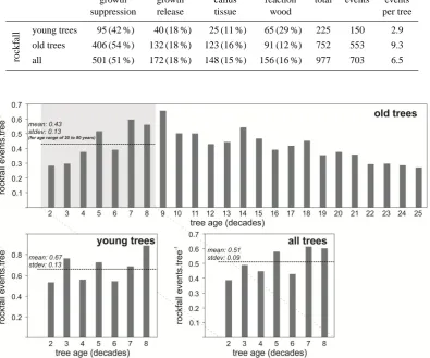
Table 1. Dated growth disturbances and number of events from both group of trees.
growth growth callus reaction total events events
suppression release tissue wood per tree
rockf
all young trees 95 (42 %) 40 (18 %) 25 (11 %) 65 (29 %) 225 150 2.9 old trees 406 (54 %) 132 (18 %) 123 (16 %) 91 (12 %) 752 553 9.3 all 501 (51 %) 172 (18 %) 148 (15 %) 156 (16 %) 977 703 6.5 503
504
505
506
507
508
509
Figure 3: Evolution of the number of recorded rockfall events per one tree in individual tree
510age decades.
511512
513
514
515
Fig. 3. Evolution of the number of recorded rockfall events per one tree in individual tree age decades.
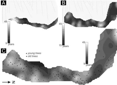
4.2 Spatial distribution of tree ages
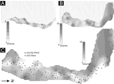
The oldest individuals (∼90 yr) from the first group (young trees) are concentrated in the central part of the talus slope (Fig. 4). This cluster is enclosed by significantly younger in-dividuals (∼50 yr) at its northern and southern margins. In comparison with the young group, the older trees do not tend to create marked spatial clusters (Fig. 4a, b). The spatial dis-tribution of tree ages reveals that the older trees (>300 yr) grow in the northern and especially southern fringes of the study site (Fig. 4b). Older trees are rather concentrated in the proximal direction with respect to the orientation of the rock cliff, whereas significantly younger individuals are situated downslope. This pattern is evident in the whole northern part of the site. Below this zone (in the southern part of belt), the youngest trees are concentrated above the old group. 4.3 Number of rockfall events (Rn)
Among the 703 identified rockfall events, 150 were observed in young and 533 in old trees. The mean number of dated
events per sampled tree is 6.2 (stdev: 3.9). Maximum and minimum values per sampled tree are 16 and 1. Event statis-tics for both groups of trees are displayed in Table 1. The spa-tial distribution of the frequency of rockfall events coincides well with the distribution of tree age. As for the young trees, the maximum frequency of events is recorded in the central part of the belt, whereas it decreases towards its northern and southern fringes (Fig. 5a). In the case of the old trees, the highest frequency of events is documented in the northern belt of trees, whereas the lowest frequency is recorded in the central zone of the belt (Fig. 5b). The distribution of rockfall events shows that the largest number of events is recorded in the northern and central parts of the slope. On the other hand, the lowest number of events is identified in the lowermost part of the talus slope, in its distal part situated in the largest distance from the cliff. Generally low numbers of events are also revealed by the trees sampled in the southern part of the studied belt.
K. ˇSilh´an et al.: Implications of spatial distribution of rockfall 1821
516
517
518
519
520
521
522
523
524
525
Figure 4: Spatial distribution of the age structure of sampled trees. A – young trees, B – old
526trees, C – all trees.
527528
529
Fig. 4. Spatial distribution of the age structure of sampled trees. A – young trees, B – old trees, and C – all trees. 530
531
532
533
534
535
536
537
538
539
Figure 5: Spatial distribution of rockfall events recorded within individual trees (R
n). A –
540young trees, B – old trees, C – all trees.
541542
Fig. 5. Spatial distribution of rockfall events recorded within individual trees (Rn). A – young trees, B – old trees, and C – all trees.
1822 K. ˇSilh´an et al.: Implications of spatial distribution of rockfall
547
548
549
550
551
552
553
Figure 6: Spatial distribution of recurrence intervals (R
i). A – young trees, B – old trees, C –
554all trees.
555556
557
Fig. 6. Spatial distribution of recurrence intervals (Ri). A – young trees, B – old trees, and C – all trees.
4.4 Recurrence of rockfall events (Ri)
The average time interval passing between two successive hits in a particular tree is 24.6 yr (stdev: 8.8 yr). The low-est recurrence interval is 9 yr, while the highlow-est equals to 49 yr. Unlike their old counterparts (mean Ri=26.3 yr), the young trees show slightly more frequent hits (mean Ri=22.3 yr). The longest recurrence interval (Ri>40 yr) of rockfall events for the young trees is recorded in the southern margin of the belt (Fig. 6a). However, this zone di-rectly borders with the zone of the lowest recurrence interval (Ri<15 yr). The northern part of the study area is charac-terised by a slightly higher frequency. The group of the old trees is characterised by alternations of zones with high and lowRi (Fig. 6b). A higher frequency of hits is rather visi-ble in the northern part of the belt. If we take into account the combination of both old and young trees (Fig. 6c), it is evident that the trees which are most frequently impacted by falling rock clasts are rather situated in the vicinity of the southern and northern borders of the study site. The northern and southern belts themselves are characterised by a lower frequency of recorded hits.
5 Discussion
5.1 Limits for the reconstruction of rockfall activity using trees of various ages
Dendrogeomorphic analysis shows that the two identified groups of trees significantly differ in the reactions to rockfall-related disturbances and their ability to record rockfall events. The number of trees has increased rapidly since the ∼1930s. This increase, which was preceded by two decades in which the number of trees remained almost unchanged (Fig. 2), can be explained by the occurrence of a moder-ate earthquake in 1919 (M=4.5) and strong earthquakes in 1927 (M=6 andM=6.8) (Nikonov and Sergejev, 1996; USGS, 2010). These events are inferred to have destroyed some of the trees and created new open space for colonisa-tion in the subsequent years, which has manifested itself in the increase of the sample depth (SD) since the 1930s.
Results displayed in Table 1 reveal that the young trees rather react more to the rockfall-related damage by the for-mation of reaction wood (in comparison to the old trees) than by the production of callus tissue. This is because the younger trees are more flexible and falling rock clasts will rather cause their tilting than damage of their bark (Stof-fel and Perret, 2006). The tilting of stems is subsequently compensated by the formation of reaction wood. Moreover,
K. ˇSilh´an et al.: Implications of spatial distribution of rockfall 1823
558
559
560
561
562
563
564
565
566
567
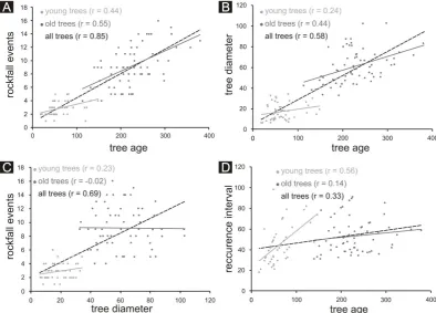
Figure 7: Graphical relationships between selected parameters of trees and indicators of
568rockfall activity.
569570
Fig. 7. Graphical relationships between selected parameters of trees and indicators of rockfall activity.
field visual analysis of sampled trees revealed that many trees were under pressure from a high layer of rockfall clasts. Gen-erally, trees tend to react intensively by the formation of com-pression wood to the lateral pressure of material released during rockfall events (Migo´n et al., 2010). The older trees gradually lose their elasticity (Dorren and Berger, 2006) and rockfall-related hits by clasts thus more frequently lead to the formation of scars on their stems. On the contrary, both groups showed almost similar results in the representation of abrupt growth suppression/release. The age of the tree signi-ficantly affects the number of rockfall events recorded within its tree-ring structure, which is supported by high correlation (r=0.85) between both variables (Fig. 7). The correlation coefficient is smaller between the age of trees and diameter of their stems (r=0.58). This is due to the fact that trees situated in the zone of active rockfall are influenced by re-peated disturbances which lead to their elimination (Stoffel and Perret, 2006; Perret et al., 2006b). Similarly, there is a relatively high correlation between recorded rockfall events and the width of particular tree stems (r=0.69). However, this relationship is not valid for the old trees (r= −0.02). We explain this feature by the existence of thick bark typ-ical of old trees that can be damaged only by voluminous and/or very fast moving rock clasts (Perret et al., 2006a). A fraction of the hits caused by rock clasts are thus not im-printed within the tree-ring archive. That is why it is
neces-sary to consider the number of reconstructed rockfall events as a minimal number.
Regarding the efficiency of the reconstruction of rockfall activity, there is a crucial relationship between the age of trees and theRi. The younger trees with very thin bark and a higher degree of elasticity display lowerRi values which are also characterised by greater variability. In comparison with the old trees, their growth is significantly more sensitive to falling rock clasts. There is generally an indirect relationship between the age of trees andRi (r=0.33) (Fig. 7). A dis-advantage of the young trees is that they only cover a very limited time period. Furthermore, their high sensitivity is not only restricted to rockfall but also to other environmental fac-tors (e.g. stress due to snow cover or wind activity). Due to this fact, at least 10 first tree rings should always be ex-cluded from the tree-ring analysis (Stoffel and Bollschweiler, 2008). In the case of the older trees, such influences are much weaker and can be identified using reference chronology. Our data reveal that it is necessary to distinguish between the two populations of trees because of the significantly differ-ent capability in the young and the old trees to record rockfall events.
the necessity to divide the resources for continuously grow-ing trunk surface and branches (Stoffel et al., 2013). In this way, the trees gradually produce thinner rings. Another rea-son may be the depletion of nutrients within a given terri-tory. However, this question has so far neither been solved nor clarified in scientific studies. If we suppose the identical sensitivity in the first decades of the growth of both groups of trees, then the higher average number of recorded rockfall events by younger trees can be explained by smaller rockfall activity in the past, when compared to the present.
5.2 Spatial distribution of the rockfall activity
One of the basic dendrogeomorphic indicators of geomor-phic process activity is the spatial distribution of age struc-tures of trees (Pierson, 2007). Regularity of the spatial distri-bution of young trees and, on the other hand, irregularity of the spatial distribution of old tree ages support the hypothe-sis that the growth of P. nigra and their colonisation of the talus slope are driven significantly by large-magnitude, seis-mically induced rockfalls. Major rockfalls are supposed to be responsible for the destruction of a large number of P. nigra individuals, enabling subsequent colonisation of openings by young trees. Zones within the talus slope overgrown predom-inantly by young individuals are assumed to have been af-fected by large-magnitude rockfall events in the past. On the contrary, parts of the talus colonised by old trees are less prone to major rockfall activity. This means that trees tend to grow older in areas which are less affected by rockfall. Less effective rockfall in such zones enabled establishment and survival of very old trees, which in turn poses a compet-itive barrier for the colonisation by young trees. Such a situ-ation is observed, e.g. on the absolute north-western margin of the talus slope, where old trees are simultaneously grow-ing in the most proximal part with respect to the position of the cliff face. This evidence suggests generally low activity of rockfall in this place. An interesting composition of the age structure of trees is also evident in the central part of studied talus, where the belt of young trees is situated be-low the belt of the old trees. Unlike a general assumption, old trees here most probably do not act as a sufficient natu-ral barrier, namely because of their small number and wide spacing. Since a similar effect is observed in the northern part of the talus, it is necessary to consider the aspects of spatial composition of trees.
The spatial distribution of the number of rockfall events (Rn) coincides well with the age structure of trees growing on the talus slope. Older trees have been able to record rock-fall events for a much longer period of time, which is a dis-advantage for the germination of young trees. Therefore,Rn is not a reliable parameter for the application within forests characterised by an irregular age structure of trees. However,
typical feature of rockfall activity, is more suitable due to the fact that it eliminates various ages of sampled trees (Stoffel et al., 2005b). Spatial distribution ofRi enables a more ex-act view on the spatial distribution of rockfall ex-activity within the talus slope. Distribution of Ri on the Taraktash talus slope supports an assumption that rockfall is more frequent in zones colonised by young trees. Rockfall events here are recorded by tree rings with the highest frequency.
6 Conclusions
The spatial distribution of rockfall activity was investigated in on a talus slope beneath a∼150 m high limestone cliff the southern Crimean Mountains. We identified 703 rock-fall events using tree-ring analysis of 114 P. nigra trees. The talus slope is colonised by two generations of trees (young and old), where younger generation is interpreted as a re-sult of the reaction to high-magnitude seismically induced rockfall events. The young trees (max. age 81 yr) are more sensitive to the rock impacts and thus allow a more de-tailed reconstruction of rockfall chronologies than do the old trees (min. age 113 yr). The ability of trees to record rock-fall events changes with time. The studied P. nigra showed a gradually increasing number of rockfall events tree−1in the first eight decades of the tree age. The highest sensitivity was identified in trees in the range of 80 to 90 yr. Starting with the ninth decade, tree sensitivity continuously decreases. Older trees stand for a very sensitive indicator of events in the past, whereas younger trees are able to record very well contempo-rary activity of rockfall processes. Hence, it is recommended to use trees with different age composition for reliable recon-struction of rockfall chronologies.
The analysis of spatial distribution of the age structure of trees growing on the talus slope reveals possible zones which have been affected by destructive effects of high-magnitude rockfall. Such places are colonised by the youngest trees. This expectation is also supported by the analysis of the aver-age period between two successive hits of a particular tree by a rock clast. The shortest average recurrence intervals are de-tected just at places with occurrence of the youngest trees. On the contrary, very old trees grow in the zones characterised by low rockfall activity with the longest average recurrence periods.
Acknowledgements. This research was supported by the project of the Czech Science Foundation no. P209/12/0317: “Late Quater-nary evolution of the complex gravitational slope deformations on the southern slopes of the Crimean Mountains (Ukraine)”. Thanks are also extended to Monika Hradeck´a for the translation review, and Veronika Kom´arkov´a, V´aclav Stacke and Marek V´aclavek for their assistance in field work. Markus Stoffel and David Keefer are warmly thanked for providing very useful comments.
K. ˇSilh´an et al.: Implications of spatial distribution of rockfall 1825
Edited by: D. Keefer
Reviewed by: M. Stoffel, J. Corominas, and one anonymous referee
References
Bollschweiler, M., Stoffel, M., Ehmisch, M., and Monbaron, M.: Reconstructing spatiotemporal patterns of debris-flow activity with dendrogeomorphologic methods, Geomorphology, 87, 337– 351, doi:10.1016/j.geomorph.2006.10.002, 2007.
Br¨aker, O. U.: Measuring and data processing in tree-ring research – a methodological introduction, Dendrochronologia, 20, 203– 216, doi:10.1078/1125-7865-00017, 2002.
Butler, D. R. and Sawyer, C. F.: Dendrogeomorphology and high-magnitude snow avalanches: a review and case study, Nat. Haz-ards Earth Syst. Sci., 8, 303–309, doi:10.5194/nhess-8-303-2008, 2008.
Casteller, A., Christen, M., Villalba, R., Mart´ınez, H., St¨ockli, V., Leiva, J. C., and Bartelt, P.: Validating numerical simulations of snow avalanches using dendrochronology: the Cerro Ventana event in Northern Patagonia, Argentina, Nat. Hazards Earth Syst. Sci., 8, 433–443, doi:10.5194/nhess-8-433-2008, 2008. Chieesi, V., D’Orefice, M., Mugnozza, G. S., Vitale, V.,
and Cannese, Ch.: Geological, geomechanical and geo-statistical assessment of rockfall hazard in San Quirico Village (Abruzzo, Italy), Geomorphology, 119, 147–161, doi:10.1016/j.geomorph.2010.03.010, 2010.
Corona, Ch., Lopez Saez, J., Rov´era, G., Stoffel, M., Astrade, L., and Berger, F.: High resolution, quantitative reconstruction of erosion rates based on anatomical changes in exposed roots at Draix, Alpes de Haute-Provence – critical review of existing ap-proaches and independent quality control of results, Geomor-phology, 125, 433–444, doi:10.1016/j.geomorph.2010.10.030, 2011.
Dorren, L. K. A. and Berger, F.: Energy dissipation and stem breakage of trees at dynamic impacts, Tree Physiol., 26, 63–71, doi:10.1093/treephys/26.1.63, 2006.
Fantucci, R. and Sorriso-Valvo, M.: Dendrogeomorphological anal-ysis of a slope near Lago Calabria (Italy), Geomorphology, 30, 165–174, doi:10.1016/S0169-555X(99)00052-5, 1999.
Frattini, P., Crosta, G., Carrara, A., and Agliardi, F.: Asses-ment of rockfall susceptibility a by integrating statistical and physically-based approaches, Geomorphology, 94, 419–437, doi:10.1016/j.geomorph.2006.10.037, 2008.
Gardner, J. S.: Rockfall frequency and distribution, Z. Geomorphol., 27, 311–324, 1983.
Golden Software.: Surfer Version 8 – Reference Manual, Golden Software Inc., CA, USA, 2002.
Gruber, S., Hoelzle, M., and Haeberli, W.: Permafrost thaw and destabilization of Alpine rock walls in the hot summer of 2003, Geophys. Res. Lett., 31, L13504, doi:10.1029/2004GL020051, 2004.
Keefer, D. K.: Landslides caused by earthquakes, Geol. Soc. Am. Bull., 95, 406–421, doi:10.1130/0016-7606(1984)95<406:LCBE>2.0.CO;2, 1984,
Lopez-Saez, J., Corono, C., Stoffel, M., Astrade, L., Berger, F., and Malet, J. P.: Dendrogeomorphic reconstruction of past landslide reactivation with seasonal precision: Bois Noir landslide, south-ern French Alps, Landslides, 9, 189–203, doi:10.1007/s10346-011-0284-6, 2012a.
Lopez-Saez, J., Corona, C., Stoffel, M., Schoeneich, P., and Berger, F.: Probability maps of landslide reactiva-tion derived from tree-ring records: Pra Bellon landslide, southern French Alps, Geomorphology, 138, 189–202, doi:10.1016/j.geomorph.2011.08.034, 2012b.
Luckman, B. H.: Rockfalls and rockfall inventory data: some obser-vations from Surprise Valley, Jasper National Park, Earth Surf. Proc. Land., 1, 287–298, doi:10.1002/esp.3290010309, 1976. Marzorati, S., Luzi, L., and De Amicis, M.: Rock falls induced by
earthquakes: a statistical approach, Soil Dyn. Earthq. Eng., 22, 565–577, doi:10.1016/S0267-7261(02)00036-2, 2002.
Matsuoka, N.: Frost weathering and rockwall erosion in the southeastern Swiss Alps: Long-term (1994– 2006) observations, Geomorphology, 99, 353–368, doi:10.1016/j.geomorph.2007.11.013, 2008.
Matsuoka, N. and Sakai, H.: Rockfall activity from an alpine cliff during thawing periods, Geomorphology, 28, 309–328, doi:10.1016/S0169-555X(98)00116-0, 1999.
Migo´n, P., P´anek, T., Malik, I., Hradeck´y, J., Owczarek, P., and ˇSilh´an, K.: Complex landslide terrain in the Kamienne Moun-tains, Middle Sudetes, SW Poland, Geomorphology, 124, 200– 214, doi:10.1016/j.geomorph.2010.09.024, 2010.
Nikonov, A. A. and Sergejev, A. P.: Seismogravitacionnyje naruse-nia reliefa v Krymu pˇri zemletrjasenijach 1927 goda, Geoekolo-gia, 3, 124–133, 1996 (in Russian).
P´anek, T., Daniˇs´ık, M., Hradeck´y, J., and Frisch, W.: Morpho-tectonic evolution of the Crimean mountains (Ukraine) as con-strained by apatite fission track data, Terra Nova, 21, 271–278, doi:10.1111/j.1365-3121.2009.00881.x, 2009a.
P´anek, T., Hradeck´y, J., ˇSilh´an, K., Smolkov´a, V., and Altov´a, V.: Time constraints for the evolution of a large slope col-lapse in karstified mountainous terrain of the southwestern Crimean Mountains, Ukraine, Geomorphology, 108, 171–181, doi:10.1016/j.geomorph.2009.01.003, 2009b.
Pelfini, M. and Santilli, M.: Frequency of debris flows and their relation with precipitation. A case study in the Central Alps, Italy, Geomorphology, 101, 721–730, doi:10.1016/j.geomorph.2008.04.002, 2008.
Perret, S., Baumgartner, M., and Kienholz, H.: Inventory and anal-ysis of tree injuries in a rockfall-damaged forest stand, Eur. J. Forest. Res., 125, 101–110, doi:10.1007/s10342-005-0082-6, 2006a.
Perret, S., Stoffel, M., and Kienholz, H.: Spatial and temporal rock-fall activity in a forest stand in the Swiss Prealps – a den-drogeomorphological case study, Geomorphology, 74, 219–231, doi:10.1016/j.geomorph.2005.08.009, 2006b.
Pierson, T. C.: Dating young geomorphic surfaces using age of colo-nizing Douglas fir in southwestern Washington and northwestern Oregon, USA, Earth Surf. Proc. Land., 32, 811–831, 2007. Schneuwly, D. M. and Stoffel, M.: Tree-ring based reconstruction
of the seasonal timing, major events and origin of rockfall on a case-study slope in the Swiss Alps, Nat. Hazards Earth Syst. Sci., 8, 203–211, doi:10.5194/nhess-8-203-2008, 2008.
ˇSilh´an, K. and P´anek, T.: Fossil and recent debris flows in medium-high mountains (Moravskoslezsk´e Beskydy Mts, Czech Republic), Geomorphology, 124, 238–249, doi:10.1016/j.geomorph.2010.03.026, 2010.
ˇSilh´an, K., P´anek, T., and Hradeck´y, J.: Tree-ring analysis in the reconstruction of slope instabilities associated with earthquakes and precipitation (the Crimean Mountains, Ukraine), Geomor-phology, 173–174, doi:10.1016/j.geomorph.2012.06.010, 174– 184, 2012.
ˇSilh´an, K., P´anek, T., Br´azdil, R., Havl˚u, D., Duˇsek, R., and Hradeck´y, J.: Dating of bedrock landslide reactivations us-ing dendrogeomorphic techniques: the Maz´ak landslide, Outer Western Carpathians (Czech Republic), Catena, 104, 1–13, doi:10.1016/j.catena.2012.12.010, 2013.
Stefanini, M. C.: Spatio-temporal analysis of a complex landslide in the Northern Apennines (Italy) by means of dendrochronology, Geomorphology, 63, 191–202, doi:10.1016/j.geomorph.2004.04.003, 2004.
Stoffel, M.: Magnitude–frequency relationships of debris flows – A case study based on field surveys and tree-ring records, Geo-morphology, 116, 67–76, doi:10.1016/j.geomorph.2009.10.009, 2010.
Stoffel, M. and Bollschweiler, M.: Tree-ring analysis in natural haz-ards research – an overview, Nat. Hazhaz-ards Earth Syst. Sci., 8, 187–202, doi:10.5194/nhess-8-187-2008, 2008.
Stoffel, M. and Perret, S.: Reconstructing past rockfall activ-ity with tree rings: some methodological considerations, Den-drochronologia, 24, 1–15, doi:10.1016/j.dendro.2006.04.001, 2006.
Stoffel, M., Li`evre, I., Monbaron, M., and Perret, S.: Seasonal tim-ing of rockfall activity on a forested slope at T¨aschgufer (Swiss Alps) – a dendrochonological approach, Z. Geomorphol., 49, 89– 106, 2005a.
using dendrogeomorphology, Geomorphology, 68, 224–241, doi:10.1016/j.geomorph.2004.11.017, 2005b.
Stoffel, M., Bollschweiler, M., Vazquez-Selem, L., Franco-Ramos, O., and Palacios, D.: Dendrogeomorphic dating of rockfalls on low-latitude high-elevation slopes: Rodadero, Iztacc´ıhuatl volcano, Mexico, Earth Surf. Proc. Land., 36, 1209–1217, doi:10.1002/esp.2146, 2011.
Stoffel, M., Casteller, A., Luckman, B. H., and Villalba, R.: Spa-tiotemporal analysis of channel wall erosion in ephemeral tor-rents using tree roots – An example from the Patagonian Andes, Geology, 40, 247–250, doi:10.1130/G32751.1, 2012.
Stoffel, M., Butler, D. R., and Corona, C.: Mass movements and tree rings: A guide to dendrogeomorphic field sampling and dating, Geomorphology, doi:10.1016/j.geomorph.2012.12.017, in press, 2013.
Trappmann, D. and Stoffel, M.: Counting scars on tree stems to assess rockfall hazards: A low effort approach, but how reliable?, Geomorphology, 180–181, 180–186, doi:10.1016/j.geomorph.2012.10.009, 2013.
USGS: Online earthquake catalogue, Earthquake Hazard Program, available at: earthquake.usgs.gov/earthquakes/eqarchives/epic/, last access: June 2013, 2010.
V.I.A.S. (Vienna Institute of Archaeological Science): Time Table, Installation and instruction manual, Rev. 2.1, Vienna, SCIEM, 2005.