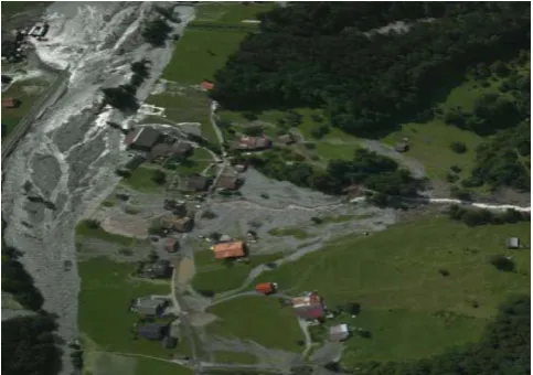
The use of airborne LiDAR data for the analysis of debris flow events in Switzerland
Full text
Figure


Related documents
Finally the aims of this study to determine the indicators of evaluate of children with mathematics learning disabilities, the level of visual discrimination
However, this would likely give rise to much litigation to determine whether this was consistent with the MSFCMA and not an overly broad reading of section 1856(a)(3)(A) of that
Field experiments were conducted at Ebonyi State University Research Farm during 2009 and 2010 farming seasons to evaluate the effect of intercropping maize with
Materials and Methods: The specificity of the assay was tested using reference strains of vancomycin-resistant and susceptible enterococci.. In total, 193
Proprietary Schools are referred to as those classified nonpublic, which sell or offer for sale mostly post- secondary instruction which leads to an occupation..
In this article, we investigate the meromorphic solutions of certain non-linear difference equations using Tumura-Clunie theorem and also provide examples which satisfy our
In the present study, although there were no histopathologically significant changes in the testes of male zebrafish, there were significant differences between
