A Framework and Software Tool to Support Collaborative
Landscape Analysis: Fitting Square Pegs into Square Holes
Andrew Fall1, Dave Daust2, and Don G. Morgan3 1School of Resource and Environmental Management
Simon Fraser University, Burnaby, B.C. V5A-1S6 Email: [email protected]
2Research Consultant, RR2 Site 23b Comp. 1, Burns Lakes, B.C. V0J 1E0 3Research Branch, B.C. Ministry of Forest, Bag 5000, Smithers, B.C. V0J 2N0
Keywords: spatially-explicit simulation, landscape ecology, disturbance modelling, adaptive resource
management, collaborative modelling, participatory design
Abstract
For landscape models to be applied successfully in management situations, models must address appropriate questions, include relevant processes and interactions, be perceived as credible and involve people affected by decisions. We propose a framework for collaborative model building that can address these issues, and has its roots in adaptive management, computer-supported collaborative work and landscape ecology. Models built through this framework integrate a variety of information sources, address relevant questions, and are customized for the particular landscape and policy environment under study. Participants are involved in the process from the start, and because their input is incorporated, they feel ownership of the resulting models, increasing the chance of model acceptance and application. There are two requirements for success: a tool that supports rapid model prototyping and modification, that makes a clear link between a conceptual and implemented model, and that has the ability to implement a wide range of model types; and a core team with skills in communication, research and analysis, and knowledge of ecology and forestry in addition to modelling. SELES (Spatially Explicit Landscape Event Simulator) is a tool for building and running models of landscape dynamics. It combines discrete event simulation with a spatial database and a relatively simple modelling language to allow rapid development of landscape simulations, and provides a high-level means of specifying complex model behaviours ranging from management actions to natural disturbance and succession. We have applied our framework in several forest modelling projects in British Columbia, Canada. We have found that this framework increases the interest by local experts and decision-makers to participate actively in the model building process. The workshop process and resulting models have efficiently provided insight into the dynamics of large landscapes over long time frames. The use of SELES has facilitated this process by providing a flexible, transparent environment in which models can be rapidly implemented and refined. As a result, model findings may be more readily incorporated into decision-support systems designed to assist resource managers in making informed decisions.
1. Introduction
Forest managers face complex problems, due to the intricate nature of forest ecosystems, often elaborate socio-economic and policy environments, and increasing local and global public scrutiny. Forests provide environmental services, social benefits and economic rewards, including clean water and air, biodiversity, scenery, recreation, opportunities for transformative experiences, and resource extraction. Legislation requires that these myriad values be considered in management (Province of British Columbia 1996)—not an easy task given the interactions among values and the variety of spatial and temporal scales over which ecological and economic processes operate. Growing public awareness and use of non-timber forest values has increased pressure, sometimes through boycotts and civil disobedience, on forest managers to treat all forest values equitably. This has resulted in increased public involvement in planning both in the US (Selin et al. 1997) and in Canada (e.g. Province of British Columbia 1999). Thus, many people, including staff, local experts, and representatives of industry and the environment, want their views to be considered and respected in decision-making. Since these stakeholders can influence the decisions that are considered or accepted, they need opportunities to learn about the problems and to contribute to the solutions.
Given this complexity, forest management problems may require a decision-support process to foster communication and shared understanding among decision-makers and stakeholders. Landscape modelling can provide a focus for sharing perspectives, learning, and integrating a variety of information. It is particularly useful when problems include aspects of natural disturbance, succession and management over long time frames and large areas (Baker 1989, Hunsaker et al. 1993, Sklar and Costanza 1991, Turner 1989). These situations often involve moderate to high levels of uncertainty and risk, and include complex spatial and temporal interactions, such as connectivity and cumulative effects. Modelling projects, however, must focus on meeting the needs of the decision-makers, not on providing technical solutions to abstracted problems, and thus a framework is needed to encapsulate model development. We believe efforts to support management decisions should aim to:
(1) increase the decision-makers’ understanding of the problem and of the consequences of management options, and
(2) provide information within a relevant time frame, and given increased public scrutiny, decision-support should also aim to:
(3) involve and inform stakeholders, and
(4) clearly document the rationale for decisions for future public review.
Models promote understanding by showing logical outcomes to sets of assumptions. In particular, the results from a sufficiently realistic, yet tractable and verified, landscape model can improve comprehension of the consequences of various management options. Generating model results and presenting them to appropriate people, however, is not sufficient to increase understanding. The target audience must have confidence in model results, rather than blind trust or unwarranted scepticism, and the knowledge of how to interpret them. This implies that people must be involved in the process of landscape model development and analysis. Due to the wide range of interests, time availability and technical skills of participants, model development should be at the conceptual, rather than implementation, level. The structured thinking imposed by the process of developing conceptual models forces participants to focus on key elements and interactions in a problem. The development process also helps separate values from information and identifies information gaps. Model development and subsequent implementation must also occur quickly to avoid producing results too late to be relevant to the decision. Improved understanding of model assumptions, behaviour and limitations can improve communication and interpretation of results from simulation experiments.
There is a clear need for a structured framework to guide the collaborative development of landscape models, and for tools to support this process. This framework should be oriented to finding solutions for a given socio-economic and ecological problem, to maximize mutual understanding, and to improve decision-making. Technology to enable this process must provide a transparent basis to implement and analyse the resulting models and management scenarios.
The notion that a group with appropriate expertise can combine talents to produce better models and solutions is not new (Clark et al. 1979, Holling 1978, Kyng 1991, Maxwell and Constanza 1997a, Selin et al. 1997). Participatory model design combines diverse sources of expertise and may generate novel solutions by exploring a wide range of scenarios, including alternatives that might otherwise not be considered (Gray 1989, Kyng 1991, Schuler and Namioka 1992). The benefits of a participatory design process extend well beyond the model produced (Kyng 1991, McLain and Lee 1996, Maxwell and Constanza 1997b, Selin et al. 1997), bringing benefits to participants such as improved understanding, communication and co-operation among stakeholders and designers; conflict resolution and consensus building; and an opportunity to influence the decision-making process. While the secondary benefits of collaborative modelling are well understood, the goal of most such processes still seems to be generating model results for a limited set of viewpoints (McLain and Lee 1996).
Although collaborative model development is fairly common, it has not been widely practised at the landscape scale due to a lack of technological support (Maxwell and Costanza 1997a). Building dynamic geographic models has been limited by computer hardware (memory and speed), data requirements, and the conceptual complexity of formulating, implementing and calibrating complex models, although these constraints have been reduced (Maxwell and Costanza 1997b). Many of the landscape models described in the literature have been developed within the framework of the scientific method. Thus, they tend to focus on research hypotheses, and to be designed to test these hypotheses. Proposals to apply such models in management contexts are inconsistent with the decision-making process.
The growing availability of existing landscape analysis models will not solve the technological problem. Applying an existing model, developed for a different purpose, forces current questions to be adapted to fit the model rather than vice versa – in essence, forcing a square peg through a round hole. Collaborative tools and processes should not constrain participants within a specific viewpoint, but instead support free thought, flexibility and reorganisation (Maxwell and Villa 1999). As well as constraining questions, an existing model can bring more insidious problems by masking their implicit assumptions, increasing the risk that interpreted model behaviour reflects artefacts of these assumptions rather than the system under study. In addition, existing models do not easily allow for input from local people.
In this paper, we describe a structured process for involving stakeholders in landscape model development and subsequent analysis. The focus on application of a collaborative process to address complex spatio-temporal issues at the landscape scale, through participation in conceptual model development, makes our approach novel. We describe modelling software that facilitates this framework by capturing conceptual landscape models fairly easily and by allowing rapid model implementation. We illustrate our landscape analysis process with an example, and conclude with observations on the approach and software used, drawing on experience from the example and other projects.
2. A Collaborative Framework for Landscape Modelling
The general framework we propose rests on the foundations of adaptive environmental planning, assessment and management (Holling 1978, Selin and Chavez 1995) and computer-supported collaborative work (Grudin 1991), but differs somewhat by emphasizing opportunities for stakeholders to have a more extensive role in conceptual model development, thereby increasing opportunities to learn. Maxwell and Costanza (1997a) propose a framework for collaborative model construction that helps multiple teams to implement various portions of a large model. While useful for some circumstances, in many resource management problems, the stakeholders do not have the time, mandate and/or technical background to actually implement models. The framework we propose targets situations in which stakeholders have issues and questions, and conceptual models to contribute to the process, but do not wish to be directly involved in model implementation. Thus, we focus on conceptual model construction, rather than model implementation, as the hub for collaboration. As with the collaborative planning approach advanced by Selin and Chavez (1995), our framework can be flexibly adapted to meet the unique needs of each new situation.
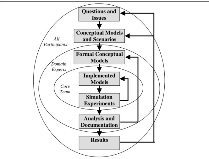
Our framework divides participants into three overlapping groups, where each group is involved in different aspects of development (Figure 1). The basic steps in our nested, iterative process are:
(1) A set of workshops allows interested parties to define relevant questions and objectives, to develop conceptual models, including key model outputs, and to provide expert knowledge and empirical data.
Usually a one or two day workshop is sufficient for the entire set of participants, followed by smaller workshops with domain experts that focus on specific model components to refine and formalize the conceptual models developed.
(2) A core modelling team assembles the required GIS information, performs analyses of the available data pertaining to the landscape in question (e.g. fire history information) and implements the formal conceptual models. Simulation experiments and analyses are used to verify equivalence between the implemented and the formal conceptual models. The team writes a document describing the conceptual models and experimental results to communicate the current status and limitations of the models to interested participants.
(3) A second round of workshops is held with the goal of completing model verification. Each of these workshops usually focuses on a specific component of the project, and includes only a subset of participants interested in that area (mainly domain experts). Participants refine the formal conceptual models, and provide new information to help parameterise models.
(4) The core team updates model implementations and documentation, runs more experiments, and analyzes simulation results. With successive iterations and increasing confidence in conceptual and implemented models, experimentation shifts from verification towards “invalidation” (Holling 1978), sensitivity analysis, hypothesis testing and scenario evaluation. Documentation of the assumptions, input parameters and results of scenario experiments is critical at this stage.
(5) A final workshop is held with all participants to present results from the scenario experiments and to discuss the implications of the results, and the status and future of the project. Participants may identify modifications to questions addressed, processes and interactions included, indicators tracked, management scenarios considered, and conceptual models developed. This completes a full iteration of the modelling cycle (Figure 1). These steps can be repeated as needed given the time constraints and complexity of the problems addressed, where the final workshop becomes the initial workshop of the subsequent iteration.
We have separated model development into three parts: (possibly informal) conceptual models, formal conceptual models, and implemented models. The goal of conceptual model development is to promote communication and learning by participants and to identify the key ecological and management processes and interactions, relevant spatial and temporal scales, and appropriate levels of detail to be included. It is important to be open to all points of view in order to make this process inclusive. Conceptual models can form a longer-term vision that is relatively unrestricted by current knowledge, data and technological limitations. The core team should encourage creativity while at the same time manage expectations of what is feasible for implementation in the short-term. The techniques to document conceptual models should be framed in a way to promote understanding among participants, and so are inherently ad hoc. The core team needs to direct this process in a constructive manner and avoid dead-end discussions.
The goal of formal conceptual model development is to create unambiguous, formal specifications of the conceptual models in conjunction with domain experts. It is important to clearly identify and document which portions of a conceptual model are currently not feasible to implement, due to limitations in understanding, data, time for implementation, or technological capability. This step may lead to recommendations for required research, data collection, or technology advance. A variety of techniques may be used for model formalization, such as graphs and equations, transition tables, Markov chains, and stock and flow diagrams. It is important to express model structure according to the viewpoints of the experts involved to maximize model clarity. However, it is critical that the core team can gather the required data, do the required background analyses and implement the formal models within the time frame allotted. The core team must balance the desire to incorporate more details and realism with the overall project goals.
The goal of model implementation is to accurately and quickly encode the formal conceptual models as a computer simulation. This goal highlights the need for modelling tools that support transparent and timely model implementation. Initial testing is required to ensure the equivalence of the formal and implemented models. During model verification, further communication with domain experts is often required to clarify and refine the models.
Figure 1. Our nested, iterative model development process. Groups participate in all circles that surround them. All participants (stakeholders, decision-makers, domain experts, core team members) set objectives, select scenarios, develop conceptual models, and discuss model results. Domain experts and the core team develop and verify the formal models. The core modelling team is responsible for organizing workshops and communication, gathering required information, implementing models, ensuring equivalence to formal conceptual models, running simulations, analyzing outputs and documentation.
2.1 Requirements for Successful Application of this Framework
The framework alone does not ensure a successful modelling project. Additional requirements for success include (1) a core team with skills in communication, research and analysis, and knowledge of ecology and forestry in addition to spatial modelling; and (2) a tool that supports rapid model prototyping and modification, that makes a clear link between a conceptual and implemented model, and that has the ability to implement a wide range of model types. Our framework is based on interactions between four components (Figure 2):
(1) Decision-makers and stakeholders set project objectives, defining the issues and questions at stake and the range of potential management actions to consider. They should be the primary beneficiaries of improved understanding gained by developing and applying the model. This group includes people who make decisions, are affected by decisions or who advocate certain values (e.g. non-governmental organizations).
(2) Domain experts and information sources provide the basis for formalizing and parameterizing conceptual models. The people involved include scientists (both local experts and domain specialists) familiar with
Core Team
Questions and
Issues
Conceptual Models
and Scenarios
Formal Conceptual
Models
Analysis and
Documentation
Simulation
Experiments
Results
Implemented
Models
Domain Experts All Participantsthe ecological processes involved, and planners familiar with the management regime. Sources of information include published literature, internal reports and studies, and databases (e.g. for GIS data). (3) Enabling technology supports the landscape analysis process as transparently as possible. Geographic
information systems are used to organize and select spatial information. The benefits of proper warehousing for spatial data to support quick extraction and preparation of information required for a modelling project cannot be under-stated. GIS is also important for static spatial analysis of input and output maps. Statistical packages may be required to analyze background data (e.g. for natural disturbance history) and simulation results. Databases, spreadsheets, graphing packages and scripting tools support the processing of potentially vast amounts of information from simulation experiments into forms more meaningful for interpretation and communication. A wide array of software programs are presently available for all of these tasks. The main gap in enabling technology has been tools to support the construction of spatial landscape simulation models, which is the topic of the next section.
(4) A core team (3-5 people) is responsible for the successful application of this framework:
(a) to co-ordinate the process by identifying and contacting potential participants, experts and data sources.
(b) to maintain communication flow among participants and maximize potential learning.
(c) to organize and facilitate workshops for defining objectives, developing conceptual models, discussing scenarios and presenting results.
(d) to analyze background information and prepare GIS information required for the simulation model.
(e) to implement formal conceptual models as a landscape simulation. (f) to verify and refine conceptual and implemented models as needed. (g) to set up and run simulation experiments, and analyze the results.
(h) to communicate model assumptions, behaviour and experiment results to participants.
Figure 2. Key components of our process. Decision-makers and stakeholders set objectives and benefit from development and analysis. Domain experts, backed by information sources, help to formalize and parameterize conceptual models. Enabling technology supports development and analysis. The core team manages the process and implements the model.
3. Enabling Technology for Constructing Landscape Simulation Models
3.1 Desirable Attributes of Collaborative Model Building SoftwareModelling tools should simplify and clarify the model development process, to help further the goal of understanding the model domain (Maxwell and Villa 1999). Software tools that aim to support collaborative landscape model building should allow the following (modified from Fall and Fall 2001, and Maxwell and Costanza 1997a): Domain Experts and Information Decision-makers and Stakeholders Core Team Enabling Technology
• Rapid implementation: To provide timely, accurate results, it should be possible to implement formal conceptual models rapidly and with certainty that the formal and implemented models agree. This implies that a language should be declarative, requiring only the salient model behaviour to be specified. • Transparency: Model assumptions should be explicit and system behaviour should be clear. By verifying
that model results derive directly from the behaviour of the specified model, users gain confidence that their interpretations of results are not influenced by implementation artefacts or hidden assumptions. • Diverse types of models: Different problems require different types of model structures, including
empirical or process-based, stochastic or deterministic, fixed time step or episodic, models of natural and anthropogenic processes, etc.
• Complex models: Knowledge and project objectives, not system constraints, should limit model complexity.
• Modularity: Modellers can more readily verify sub-model behaviour and develop experimental scenarios when models are composed of autonomous components that interact.
• Efficient processing: To facilitate stakeholder participation, relatively large and complex models should run on commonly available hardware (e.g. desktop computers).
• Easy modification: To benefit from existing work, a modeller should be able to quickly transport the underlying model behaviour to a new system. Due to scale and landscape-specific issues as well as data availability, direct re-use is not always feasible. Ease of modification also supports iterative model development. An iterative development process, that allows initial model prototypes to be successively refined, supports changes in questions and conceptual models as they evolve over time.
• Easy documentation: Model code should be easily translated to a conceptual description to support participation of non-modellers.
3.2 Tools for Implementing Dynamic Spatial Landscape Models
Options for model implementation range from using a programming language to using a pre-existing model (Fall and Fall 2001). Intermediate approaches include using software libraries, very general, flexible models and domain-specific modelling languages.
Directly implementing landscape models in a general-purpose programming language provides flexibility, but the resulting model may be difficult to verify, to modify or to compare with other models. Since most GIS systems have limited or no support for dynamic modelling, implementing dynamic spatial models within a GIS requires direct programming with the above drawbacks. Conversely, parameterizing a generic model of a particular landscape process (e.g. a fire model) is simple, but may introduce unknown assumptions, and may limit the scope and the scale of the analysis.
One intermediate approach has been to provide a software library for building specific classes of models. This “programmer’s toolbox” approach can substantially reduce implementation time and increase the reliability of a program. A modeller using such a toolbox provides the higher-level code, usually written in a general purpose programming language, that specifies how the objects are put together to produce the desired model behaviour. For example, EcoSim (Lorek and Sonnenschein 1998) provides a public domain set of C++ classes to assist in the construction of spatial landscape and individual-based models. Swarm (Minar et al. 1996) takes this approach one step further by providing a set of graphical tools for the display and analysis of model output, in addition to a rich set of Objective C classes useful for individual-based modelling. These approaches are well suited to modellers who possess good programming skills and require substantial flexibility. They allow the modeller to focus more on the conceptual model at hand, but they still require programming expertise.
An alternative approach has been to implement general models with an extensive set of parameters to control pre-built model behaviour. TELSA (Klenner et al. 1997) and LANDIS (Mladenoff et al. 1996) are recent examples of this approach applied to dynamic spatial landscape modelling. LANDIS represents the forest with a fixed structure that can be parameterised for an arbitrary number of tree species, each with individual ecological characteristics. TELSA allows the modeller to specify both the number and type of spatial layers, and the number and complexity of relationships between layers. Models built with TELSA are based on some of the landscape classification principles developed for British Columbia (Meidinger and Pojar 1991), and are primarily used for modelling the interaction between succession, natural disturbance regimes, and logging. Implementing models using such tools allows comparatively rapid model development, and
avoids programming. However, much of the model behaviour and assumptions are embedded in the program, and may not be explicit or easily modified.
Domain-specific modelling languages lie between programming languages and general models. They support construction of classes of models rather than individual model types. They make fewer assumptions about the underlying structure of the implemented model than do pre-programmed models. For example, Petri nets (Groenwold and Sonnenschein 1998) provide a graphical technique for describing the dynamics of cellular automata (synchronous cell-based models). This technique for specifying system dynamics requires no programming, yet has a formal semantics that enforces an unambiguous interpretation of the model specification. RAMAS-GIS and PATCH (Boyce 1996, Schumaker 2000) support exploration of spatial population dynamics in a static landscape. STELLA (Costanza et al. 1998) is a tool for graphically building and running stock and flow type models (Forrester 1961). Although STELLA models are aspatial, this framework offers the potential to specify within-cell dynamics in a spatial context (Maxwell and Costanza 1997b). The goals of the Spatial Modelling Environment (SME) (Maxwell and Costanza 1997a) are similar to those of SELES (discussed below), with a focus on modularity, collaborative model implementation, and transparency of run-time hardware. SME provides a language for specifying modular spatio-temporal models, and translates such models into C++ code that is linked with the SME driver.
3.3 Spatially Explicit Landscape Event Simulator
SELES (Spatially Explicit Landscape Event Simulator) combines discrete-event simulation with a spatial database and a relatively simple modelling language to allow rapid development of landscape simulations (Fall and Fall 2001). At the heart of SELES is a high-level, declarative modelling language used to specify processes acting in a model and a simulation engine that interprets and executes such models (Fall and Fall 1999). Time in SELES is a continuous variable; the engine takes care of processing events in their chronological order. Thus, time steps may vary in size and processes with different temporal resolutions can be integrated.
The class of dynamic spatial models that can be built with SELES is necessarily restricted, but SELES provides a structured framework for developing models within this class. The SELES language is sufficiently general to facilitate the construction of models that are quasi-continuous, periodic, or episodic; that are deterministic, process-oriented, or stochastic; and in which processes may operate locally, regionally, or globally and be either spreading or non-spreading (Fall and Fall 1999, 2001). SELES models can include aspects of cellular automata (Itami 1994), difference equations, event-based simulation (de Vasconcelos and Zeigler 1993), and spatio-temporal Markov chains (Baltzer et al. 1998). Model specifications serve as a fairly clear description of their semantics, and thus models may be easily compared, modified, and reused.
The SELES framework considers landscape change to arise as the result of definable events that occur in specific places and at specific times. The behaviour of these events depends on model state (both prior and current), and, in turn, events change the state of the system, both locally and globally. By controlling spatial and temporal contexts, users can create models of various forms, and can study how consequences of changes in states (e.g. caused by disturbance agents, management regimes, etc.) combined with changes in structure and process (e.g. loss of connectivity between habitats, loss of species, etc.) interact to generate changes in ecosystem function.
All SELES models are spatially explicit, with the spatial plane consisting of one or more raster layers (grids) of an arbitrary, but common, extent or resolution. The basic spatial unit is a cell. A SELES model consists of two components:
• State Description: A set of raster layers and global variables together define the landscape state. These include layers that may change during the simulation (e.g. CanopyDensity and ForestAge), and layers that are static (e.g. Slope and Elevation). The initial state for each layer can be defined by a digital map from a GIS, a classified digital image from remote sensing, or a synthetic map from one of the SELES static landscape models.
• Agents of Change: A set of landscape events defines the model behaviour. A landscape event is a generic framework for describing the characteristics of an agent of change, and forms a semi-independent sub-model that usually reflects a single key process (e.g. seed dispersal, fire, ungulate grazing, timber harvesting). A landscape event may specify global behaviour (e.g. the interval between insect infestations on the landscape); local behaviour (e.g. the likelihood of infestations in forest stands of
different ages); and a set of consequent effects or state changes (e.g. reduced canopy cover in cells following an insect infestation). Feedback mechanisms between different processes are accomplished through state transitions on raster layers or global variables, with no direct inter-event communication.
A complete set of initial state information and landscape events form a simulation scenario. A simulation scenario can be processed by the simulation engine, either as a single run or as a set of Monte-Carlo runs. When a simulation begins, the specifications for all landscape events in the scenario are loaded into an internal format that facilitates efficient execution.
As a simulation environment, SELES facilitates setting up and running experiments. Since SELES models usually contain stochastic elements, multiple (Monte-Carlo) replicates are generally required. In addition, multiple scenarios often need to be run to address uncertain parameters or to test management options. The SELES modelling environment supports setting up and running multiple replicates of multiple scenarios. The outputs from a single scenario may include summary statistics, individual spatial layers or summarised spatial layers (e.g. the total times each cell burns in all replicates). We designed SELES to be used in conjunction with other analysis tools, such as GIS and statistics packages and visualization tools (e.g. Carpendale et al. 1999), and tried not to duplicate tasks adequately handled by existing tools. A simulation experiment produces a (possibly vast) data set. Analysis and interpretation of experiment output is generally accomplished outside of SELES.
4. Beetle-caribou Case Study
The following case study illustrates application of our framework in a large scale, complex ecosystem with conflicting values. A recent mountain pine beetle (Dendroctonus ponderosae Hopk.) outbreak in the Lakes Forest District of west-central British Columbia has highlighted a potential conflict between beetle-related control and salvage efforts and woodland caribou (Rangifer tarandus caribou) conservation efforts. The Tweedsmuir-Entiako caribou herd, consisting of about 400 caribou, passes through the Chelaslie area of the Lakes Forest District on the way to and from primary wintering grounds (Cichowski and Banner 1993, Steventon 1996). The portion of this migration corridor included in the managed forest has been designated for special management (Province of British Columbia 1999). Threats to caribou while traversing this corridor include loss of lichen forage, increased mortality associated with increased road access, and barriers to movement created by dense young stands or large areas of downed trees (Steventon et al. 1998).
The beetle-caribou issue has led to considerable debate about the benefits to timber, and the costs to caribou, of beetle control efforts. Beetle management strategies aim to limit the growth and spread of mountain pine beetle populations by reducing population levels and decreasing susceptibility. Numerous perspectives exist because people have different areas of expertise, interactions are complex, and considerable uncertainty surrounds the risks to caribou and the effectiveness of beetle control under outbreak conditions. The issue has generated a flurry of research and inventory work aimed at supporting management decisions. The BC Ministry of Forests initiated a project to systematically analyse issues in the Lakes District using landscape simulation modelling. The project aims to:
• clarify the probable consequences of management options, including the impacts of uncontrolled mountain pine beetle, beetle control and salvage of beetle-killed trees on caribou and timber,
• share information with the interested public and stakeholders, • provide a long-term perspective of the problem,
• explain uncertainty and risk, and • develop a strategic response to beetles.
4.1 The Model Development Process
We began this project with a set of workshops to develop key questions and important relationships, to identify data requirements and availability, and to discuss management constraints and alternatives. The interested stakeholders in this process included government (BC Ministry of Forests, BC Ministry of Environment and BC Parks), industry (the two logging licensees working in the area), an environmental
representative and domain experts (including scientists from the Canadian Forest Service and the local area). As is often the case, there was overlap between stakeholders and domain experts.
Detailed discussions with domain experts, including caribou biologists, mountain pine beetle experts and planners, followed the workshops. Domain experts provided advice, literature and contact information for other experts. Different levels of uncertainty were identified in the various domains: we have relatively higher confidence in projecting timber harvesting than we have for future mountain pine beetle outbreaks, and we have the least knowledge of the effects of different indicators on caribou populations.
The core team then gathered background and GIS information, implemented and verified the first versions of the sub-models, ran simulation experiments, analyzed the output and documented the model and experimental results. Frequent communication with domain experts aimed to ensure consistency between the conceptual and implemented models, but due to the tight time constraints for the project, we were unable to fully discuss formal models and model results with domain experts in workshops prior to running experiments. Missing this important step to meet the fiscal and decision-making time frame could be problematic for a one-phase project, but in the context of this project workshops with domain experts were scheduled as one of the first tasks of a second phase. We then held a second workshop for all participants in which we presented the current status of the model and experimental results, and collaboratively discussed gaps in data and knowledge, additional processes and scenarios to include and future direction for the project.
This project has completed the main cycle in our model development process (Figure 1). Phase I (Jan 2000 – Mar 2000) demonstrated the feasibility of developing a fairly realistic model of interactions among mountain pine beetle, forest management and caribou for the Lakes District, and has produced some preliminary results.
4.2 Model Overview
This model simulates the impacts of forest disturbance and re-growth on caribou and timber. Disturbance agents include logging and mountain pine beetles, but we chose to omit fire at this time. Re-growth focuses on lichens and timber. The model tracks changes in the age and volume of timber, in the abundance of lichens, in the population of mountain pine beetles, and in a set of variables that influence the caribou population. Disturbance can have direct effects by, for example, reducing timber volume or removing beetles and indirect effects by, for example, reducing canopy closure, thereby reducing lichen abundance with consequences for caribou. The type of disturbance determines the degree of impact. For example, clearcutting removes all live and dead stems in a stand; mountain pine beetles kill a proportion of live trees.
The description of the forest state is central to the model, and focuses on components important to logging, caribou and mountain pine beetles: stand age and species, arboreal and terrestrial lichens, and standing dead and downed wood. Static spatial information includes elevation, aspect and site quality. Aspatial information includes harvest volume curves. The spatial database describing the landscape consists of a series of grid-based maps derived from forest inventory information for the district. The spatial extent of the district is approximately 1.1 million ha, which we decided to model at a resolution of 6.25 ha (250 m by 250 m cells).
4.2.1 Caribou Sub-model: In conjunction with local caribou experts (from BC Ministry of Forests and a consultant), we identified a variety of caribou indicators to track. Many effects act indirectly (e.g. increasing road density may increase hunting pressure by humans and wolves) or depend on factors outside the scope of the model (e.g. number of moose hunting licenses sold, and mortality in the summer range). In the final analysis, domain experts need to consider caribou indicators in the context of indirect effects and factors not modelled. Forage is primarily tracked via a lichen sub-model that simulates the loss and growth of terrestrial and arboreal lichens, critical food sources in this area. Barriers to caribou movement and access to terrestrial lichens include downed wood, deep snow (correlated with canopy openness) and noise (linked to logging activity and road access). Large concentrations of downed wood result from snags falling years or decades after tree mortality from mountain pine beetle. Causes of mortality important in the migration corridor include wolf predation, traffic collisions (linked to road density and logging activity), shootings (linked primarily to road access), and unknown reasons (Cichowski 1993). Although estimated impacts are uncertain, wolf predation likely increases directly with increased road densities (if roads ease moving and hunting), and indirectly with recently disturbed areas (if moose increases support a larger wolf population).
4.2.2 Mountain Pine Beetle: The mountain pine beetle (hereafter, just “beetle”) sub-models were developed collaboratively through several workshops with experts at the Canadian Forest Service (Pacific Forestry Centre) and with the regional entomologist in the BC Ministry of Forests. Populations of beetles exist at low levels throughout pine forests in all forest regions in B.C. Periodically, populations grow by one to two orders of magnitude to “outbreak” levels and remain high for several years. The progress and duration of an outbreak depends mainly on the abundance and distribution of susceptible stands and on winter and summer weather. Our model expands on stand level modelling that Canadian Forest Service researchers have been developing over the last few years (Safranyik et al. 1999) and employs a hazard rating system that ranks the susceptibility of stands to infestation (Shore and Safranyik 1992).
4.2.3 Logging: The logging regime, including beetle management, was developed through meetings with local and regional planners, and industry representatives. Our first goal was to implement a general logging model that matched current practice and policy. We then added additional components deemed important by stakeholders to address beetle infestations:
(1) beetle management efforts (proactive logging) (2) salvage of beetle killed wood (reactive logging) (3) access restrictions
Beetle management efforts include felling and burning individual infested trees, logging small groups of infested trees, logging entire stands that have infested trees, and logging high susceptibility stands. Much of the study area is currently unroaded, and beetle management is limited by road access. The logging sub-model simulates road development.
4.2.4 Preliminary Results: In the first phase of this project, we wished to ask the question: will beetle management influence beetles, harm caribou and/or benefit timber? Managers need immediate guidance; however, limits to knowledge and inherent natural variability (e.g. weather) does not allow a single outbreak to be modelled with confidence. We examined the effects of beetle management over a 200 year time period. We simulated five different forest management treatments and a no-management control, by varying selected parameters in the model; the no-management control allows beetles to run their course. To characterise each treatment, we calculated the mean and standard error of ten replicates for a number of beetle, caribou and timber related variables monitored. Preliminary results indicate two distinct periods occur during simulation: the current outbreak (years 0 – 30) and the distant future (years 175 – 200). The interim period produces more variable results. This experiment highlighted that the current outbreak is unusually large, and that beetle management may have very limited influence on it. The current beetle outbreak will create a low point in caribou habitat values (mature forest, lichens). Although salvage logging can reduce unsalvaged loss by a small amount in the current outbreak, it also compounds the risks to caribou, in particular by increasing road access required to recover wood in the short-term, and by increasing the rate of loss of lichens. In the longer term, changes in age class structure of the forest resulting from regular logging may reduce future beetle populations, and limit future outbreaks.
5. Discussion
We have proposed a framework for tackling complex forest management problems. It aims to address relevant questions, involve appropriate people and use a format that promotes discussion and learning – building a square hole for the square peg. We have found that a fairly small core team (3-5 people) is essential to carry out this process, in order to combine a range of skills while maintaining streamlined communication among team members. Collectively, the core team must possess expertise in several disciplines, preferably with most required skills shared by more than one team member, including:
• Problem domain: to initiate the mutual learning process, the core team should have at least a basic knowledge of the problem domain, including the important ecological and management processes. The core team should have some information regarding important people to contact, domain experts, and data sources.
• People skills: Communication and facilitation are two critical skills, which are supported by good oral and written skills.
• Technical skills: A solid understanding of GIS, ecology, forestry, modelling, formal analysis, and statistics is critical to achieve credibility. It is particularly important for all team members to have a good understanding of the benefits and limitations of spatio-temporal modelling in order to help guide participants during model development.
Landscape simulation can illustrate some basic principles of landscape ecology. Our experience suggests that foresters and other participants in forest-use decisions have difficulty visualizing the consequences of decisions over large spatial and temporal scales. Stands of trees, covering millions of hectares, change in structure and function over decades and centuries. In the field, foresters may explore a few hectares for a few days. They may make 5 to 20 year plans for several thousand hectares. Thinking about hundreds of thousands of hectares over hundreds of years requires a shift in perspective. The framework we propose assists learning about interactions between landscape processes, consequences of management actions, and cumulative effects over long time periods and large areas.
When using a collaborative framework, the indirect benefits of a project, including communication and learning, are often of great value even when tangible products (e.g. models and reports) are not achieved (for whatever reasons, technical, social, political, etc). Decisions for complex problems are based on information from a multitude of sources, of which concrete model results is just one. Increased understanding of the problem by stakeholders may be more critical to making good decisions.
We have not tested our framework in, nor do we recommend it for, high-conflict situations. Social obstacles to participatory frameworks include excessive levels of conflict that impedes constructive debate, exclusion of some stakeholders who have indirect influence on decision-making, and valuing some viewpoints more than others.
A major challenge for our proposal is the need for technology to support this process. A variety of available geographic information systems, statistical packages, database systems, etc. fit the needs of some portions of our framework. However, there are few software tools for constructing spatio-temporal models. SELES is a modelling environment that enables rapid and flexible implementation of formal conceptual landscape models. In the context of our framework, a critical aspect of SELES is that it puts the modelling technology in the “back seat” of the process, allowing participants to focus on the conceptual model. The core modelling team ensures that the gap between the conceptual models developed as a goal and the implemented models is as small as possible and well documented. A well-documented conceptual model also provides a clear set of assumptions that can form a substantial part of the rationale supporting subsequent decisions.
SELES functions well in a decision-support role because:
• It uses a declarative modelling language. This language supports rapid model development relative to a programming language, because many computer-related details need not be addressed. It supports transparency and easy documentation, because all specific model behaviour must be explicitly stated. The only assumptions that users must be aware of are the semantics of landscape events. The SELES modelling language also supports easy modification because the code is easy to read and relatively short, and thus makes a clear and unambiguous link between a formal conceptual model and its implementation. • It is flexible, supporting a wide range of model types. SELES models do not have specific data and model requirements, so modellers include the level of detail suitable for the modelling task. The primary restrictions in SELES are that spatial information must be raster-based and that models must be discrete-event simulations.
• It promotes modular development. A scenario is decomposed into a set of semi-independent, interacting sub-models (i.e. landscape events). Each landscape event is further decomposed into a set of properties, each responsible for key components of model behaviour. Modularity is important for several reasons. Modular model development reduces time requirements for experts, since they only need to be involved in the detailed development of models in their area of expertise. Specifying sub-models separately eases the conceptual burden of modelling complex systems. Additionally, different sub-models can be selectively included in a scenario without modifying the other events, facilitating model verification,
refinement, and experimentation. Due to the transparent, modular nature of SELES models, adapting landscape events to other modelling projects is straightforward.
An early landscape management project involving one of the authors in which this process was not applied ran into problems at the presentation stage. The core team developed a landscape model with provincial range and fire experts to explore interactions between logging, fire and grazing at a grassland-forest interface. We presented the results of the first phase to a regional audience, who voiced a variety of objections, primarily the fact that we hadn’t incorporated forest encroachment into grasslands, a major concern of range managers. We added a simple encroachment sub-model, which we demonstrated in the second day of the workshop, resulting in renewed interest in the project. This case illustrates the importance of involving stakeholders from the start, of having a flexible open process, and of having access to a powerful modelling tool.
We applied our framework from the start in the Lakes Forest District beetle-caribou project described in Section 4. This project has been useful as a forum to develop shared understanding and to discuss long-term impacts of mountain pine beetles and management on caribou and timber supply. We aimed to keep detailed discussions outside of the main workshops to use participant time efficiently, but still needed to give stakeholders an opportunity to learn about and contribute to key model relationships—a difficult balancing act. The experiment results have been useful to illustrate some trends and risks associated with different management options, even given the preliminary nature of some sub-models. During several discussions, our process helped to highlight different perceptions of beetle behaviour, caribou responses, and options available for management.
In the past, modelling has failed to reach its potential as a decision-support tool in the forest management arena. Since the emergence of computer science, simulation modelling has defined a solid niche in many scientific fields, judging by the numerous published models. The application of models in forest management seems less successful—the calculation of timber-supply being the only consistent application of modelling. Yet the complexity and large spatial and temporal scales that characterize forest management problems suggest modelling should help. Land-use decisions can profoundly impact our economy and our ecology, with consequences that may reach forward several generations. Wise decisions seem essential. While the framework and software discussed in this paper aim to improve the quality of decisions, similar frameworks, passable software and modelling expertise have existed for many years. Critics have identified flaws in existing frameworks (McLain and Lee 1996) and software has had limitations, but we believe decision-support projects have failed primarily for two reasons. First, modellers and decision-makers do not understand each other’s objectives and limitations. Decision-makers must often decide quickly, using available information and subjective judgement, and they may have unreasonable expectations about what can be modelled. Modellers, on the other hand, often aim for efficient elegant models, backed by thorough research, and are not unduly constrained by time. Second, influential stakeholders have not been adequately included in modelling projects (McLain and Lee 1996, Selin et al. 1997). In one sense, the framework and software we propose simply aims to align the objectives of the modellers and the decision-makers (including stakeholders). If this main aim is remembered, then we believe the benefits of collaborative decision-support outweigh any criticisms.
6. Conclusions
Problems at the landscape scale have a number of challenging characteristics, including large spatial and temporal extents, complex processes that occur at various scales and interact, and uncertainty in the underlying data and in the understanding of key processes. Large areas hold many values, thus bringing diverse interests to the decision-making process. Increasing public involvement in forest management requires collaborative decision-support processes. Ultimately, decisions are made in a socio-political setting and depend on perspectives as well as information, so decision-support frameworks must be human centred to provide opportunities for a group of stakeholders to discuss perspectives, to learn about social, economic and ecological values in the forest, and to assess possible consequences of management alternatives, with the final goal of a shared vision.
For spatio-temporal modelling to adequately support decision-making in such systems, the modelling process must adapt to fit the decision-making process not vice versa. Traditional scientific approaches, in which research is done independent of management, have built models to address key questions (of both researchers and managers), but without considering how best to affect decision-making. Beyond making a potentially useful model, we believe that the goals of landscape modelling should include (1) increasing understanding of decision-makers, (2) providing information in a relevant time frame, (3) involving and informing stakeholders, and (4) documenting rationale for decisions. Because each management problem has unique characteristics and questions, frameworks to build models serve better than application of existing models. The framework we describe above is people and issue centred, not technology centred, with the focus on the conceptual models, scenarios and outputs (e.g. indicators).
Technology is required to support this framework and to allow model development to be focused at the conceptual level. Software tools must be flexible in order to set up, implement and run models, and to analyze alternative scenarios. They must accelerate implementation so that it does not become the focus of the project. GIS is a critical enabling technology, particularly to bring together data from a variety of sources and formats and for static spatial analysis of landscape patterns. Data must follow consistent standards and integrate seamlessly so that it is readily available when needed. Commitment to using GIS data warehousing capabilities has been essential to successful application of our framework. SELES provides a flexible tool for implementing spatio-temporal landscape models that facilitates participatory model design, allows rapid model implementation, and supports dynamic spatial analysis of landscape pattern and process.
Acknowledgements
We would like to thank Karen Price, Marie-Ange Fall and anonymous reviewers for giving feedback on this paper. We would also like to acknowledge some of the participants in the Lakes Forest District project, including Bob Murray, Kevin Kriese, Doug Steventon, Ken White, Hubert Burger, Tan Calhoun, Debbie Cichowski, Merima Domazet, Lyle Gowalko, Eric Hannula, Gunter Hoehne, Jennifer Lecuyer, Tom Olafson, Mark Price, Jim Richard, Bill Riel, Les Safranyik, Terry Shore, John Stadt, Judy Stratton, Mike Watson, and Andy Witt.
References
Baker W L 1989 A review of models of landscape change. Landscape Ecology 2: 111-133
Baltzer H, Braun P, and Koehler W 1998 Cellular automata models for vegetation dynamics. Ecological Modelling 107: 113-125
Boyce M 1996 Review of RAMAS/GIS. Quarterly Review of Biology 71: 167-168
Carpendale M S T, Cowperthwaite D, Tigges M, Fall A, and Fracchia F D 1999 The Tardis: a visual exploration environment for landscape dynamics. In Proceedings of the Visual Data Exploration and Analysis VI, SPIE Conference, San Jose, CA. Volume 3643: 110-119
Cichowski D B 1993 Seasonal movements, habitat use, and winter feeding ecology of woodland caribou in west-central BC. Victoria, BC, Canada, Ministry of Forests Land Management Report Number 79
Cichowski D B and Banner A 1993 Management strategy and options for the Tweedsmuir-Entiako caribou winter range. Victoria, BC, Canada, Ministry of Forests Land Management Report Number 83
Clark W C, Jones D D, and Holling C S 1979 Lessons for ecological policy design: a case study of ecosystem management. Ecological Modelling 7: 1-53
Costanza R, Duplisea D, and Kautsky U 1998 Ecological modelling and economic systems with STELLA. Ecological Modelling 110: 1-4
Fall A and Fall J 1999 Beauty and the beast: separating specification from implementation for models of landscape dynamics. Burnaby, Canada, Simon Fraser University Technical Report SFU CS TR 99-06 Fall A and Fall J 2001. A domain-specific language for models of landscape dynamics. Ecological Modelling (to appear)
Forrester J W 1961 Industrial Dynamics. Cambridge, MA, MIT Press
Gray B 1989 Collaborating: Finding Common Ground for Multi-party Problems. San Francisco, Jossey Bass Groenwold A and Sonnenschein M 1998 Event-based modelling of ecological systems with asynchronous cellular automata. Ecological Modelling 108: 37-52
Grudin J 1991 Computer-supported cooperative work. Special Issue: Collaborative Computing, Communications of the ACM, 34(12): 30-34
Holling C S 1978 Adaptive Environmental Assessment and Management. Chichester, John Wiley and Sons Hunsaker C T, Nisbet R A, Lam D C, Browder J A, Baker W L, Turner M G, and Botkin D B 1993 Spatial models of ecological systems and processes: the role of GIS. In Goodchild M F, Parks B O, and Steyaert L T (eds) Environmental Modelling with GIS. New York, Oxford University Press
Itami R 1994 Simulating spatial dynamics: cellular automata theory. Landscape and Urban Planning 30: 27-47
Klenner W, Kurz W A, and Webb T M 1997 Projecting the spatial and temporal distribution of forest ecosystem characteristics. In Proceedings of GIS ‘97. Fort Collins, CO, GIS World Inc: 418–421. Also WWW Document, http://www.essa.com/forestry/telsa
Kyng M 1991 Designing for cooperation: cooperating in design. Special Issue: Collaborative Computing, Communications of the ACM, 34(12): 65-73
Lorek H and Sonnenschein M 1998 Object-oriented support for modelling and simulation of individual-oriented ecological models. Ecological Modelling 108: 77-96
McLain R J and Lee R G 1996 Adaptive management: promises and pitfalls. Environmental Management
20(4): 437-448
Maxwell T and Costanza R 1997a A language for modular spatio-temporal simulation. Ecological Modelling
103: 105-113
Maxwell T and Costanza R 1997b An open geographic modeling environment. Simulation Journal. 68: 175-185
Maxwell T and Villa F 1999 Collaborative modular modeling of environmental systems. WWW Document, http://kabir.cbl.umces.edu/Tom/Papers.html
Meidinger D and Pojar J (eds) 1991 Ecosystems of British Columbia. Victoria, BC, Canada, Ministry of Forests Special Report No 6
Minar N, Burkhart R, Langton C, Askenazi M 1996 The swarm simulation system: A toolkit for building multi-agent simulations. WWW Document, http://www.santafe.ed/projects/swarm
Mladenoff D J, Host G E, Boeder J, and Crow T R 1996 LANDIS: A spatial model of forest landscape disturbance, succession and management. In Goodchild M F, Steyaert L T, Parks B O, Johnston C, Maidment D, Crane M, and Glendinning S (eds) GIS and Environmental Modeling: Progress and Research Issues. GIS World Books, Boulder, CO: 175-180
Province of British Columbia 1996 Forest practices code of British Columbia Act. Queens Printers, Victoria, BC, Canada
Province of British Columbia 1999 Draft Lakes district land and resource management plan. Burns Lake, BC, Canada, Ministry of Forests internal report
Safranyik L, Barclay H, Thomson A, and Riel W G 1999 A population dynamics model for the mountain pine beetle, Dendroctonus ponerosae, Hopk. (Coleoptera: Scolytidae). Victoria, BC, Canada, Pacific Forestry Centre Information Report BC-X-386
Schuler D and Namioka A (eds) 1992 Participatory Design. Hillsdale, N J, Lawrence Erlbaum Associates Schumaker N 2000. PATCH: A pattern analysis tool for identifying critical habitat. In Johnson D and O’Neill T A (eds) Wildlife-Habitat Relationships in Oregon and Washington. Oregon, Oregon State University Press (to appear).
Selin S and Chavez D 1995 Developing a collaborative model for environmental planning and modelling. Environmental Management 19(2): 189-195
Selin S W, Schuett M A, and Carr D S 1997 Has collaborative planning taken root in the National Forests? Journal of Forestry, 95(5): 25-28
Shore T and Safranyik L 1992 Susceptibility and risk rating systems for the mountain pine beetle in lodgepole pine stands. Victoria, BC, Canada, Pacific Forestry Centre Information Report BC-X-336
Sklar F H and Costanza R 1991 The development of dynamic spatial models for landscape ecology: A review and prognosis. In Turner M G and Gardner R H (eds) Quantitative Methods in Landscape Ecology. New York, Springer-Verlag: 239-288
Steventon J D 1996 Caribou habitat use in the Chelaslie River migration corridor and recommendations for management. Victoria, BC, Canada, Ministry of Forests Land Management Handbook 37
Steventon J D, Stadt J, and Cichowski D B 1998 Risks to caribou of management options for the Entiako proposed protected area: report to the interagency management committee. Smithers, BC, Canada, Ministry of Forests, Prince Rupert Region internal report
Turner M G 1989 Landscape ecology: the effect of pattern on process. Annual Review of Ecological Systems
20: 171-197
de Vasconcelos M and Zeigler B 1993 Discrete-event simulation of forest landscape response to fire disturbance. Ecological Modelling 65: 177-198