PROBLEM BASED LEARNING FOR GIS TRAINING
Calvo Melero, Miguel
EEGECS (European Education in Geodetic Engineering, Cartography and Surveying Thematic Network) Laboratory of Experimental Cartography and GIS. Basque Country University (Spain),[email protected]
Abstract: The Geographical Information Systems (GIS) are tools used by a broad number of professionals. The GIS courses will be designed and developed using new tools to make them motivate to learn, with flexible schedule and opened to all the potential students joining techniques and tools like: Problems Based Learning, e-learning and self learning. We can design it with a group of professors and students like before, but now the difference is that they can live any place and that we have now new and powerful tools to prepare courses.
TEACHING AND LEARNING GIS
GIS are software used by a lot of professionals with a very different formation level. We can find students with knowledge in geographical analysis who have lacks in computer studies, others specialized in sociology who have lacks in basic knowledge related to the GIS…, but all of them have something in common: they need to use a GIS.
In the Laboratory of Experimental Cartography and GIS of the Basque Country University we started teaching GIS in 1992. Then students had to use the keyboard exhaustively to work with the GIS and the computer interface was very poor (Windows 98 didn’t exist).
Our experiences show that learning GIS was boring for students and hard for the teachers. The students who passed the courses were very limited. At that time before targeting the resolution of the problems it was necessary, in a first phase, to explain the available commands, the parameters and options and their effects. Once the students acquired a certain level they proceeded to the resolution of some problems. With this method some students were discouraged and they lost interest in GIS.
With the development of new interfaces (specially with Windows 95) much easier to use, students learn quickly how to work with the GIS and we can focus our teaching on the possibilities and effects of the geographic data management, algorithms and applications.
Our university offers GIS subjects for the Environmental Sciences degree and for Survey Engineering, but we also have lessons designed for companies that request specific GIS training. This has made us acquire experience in teaching stu-dents with very different orientation, objectives, formation or career (insurances, security, sociology, employment, land use, planning).
Companies usually request us 26 hour courses to obtain a maximum handling level (skills) about GIS use. Many of the students haven’t got enough motivation to study the course and for that reason we have to develop courses which can motivate them. On the other hand there are many GIS programs at the market and companies demand courses which are adapted to the program they use and focused on their professional areas. All these factors make us design short, amusing, motivating courses, with a variety of GIS software and at the same time they must be adapted to the student’s profiles, and professional skills.
HOW DO WE GET OUR COURSE READY?
In order to prepare the courses we decide to develop a structure in four levels according to the GIS data management and the process of “decision making”. These levels are:
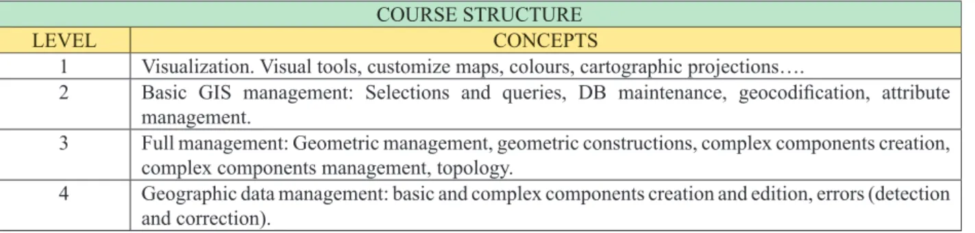
COURSE STRUCTURE
LEVEL CONCEPTS
1 Visualization. Visual tools, customize maps, colours, cartographic projections….
2 Basic GIS management: Selections and queries, DB maintenance, geocodification, attribute management.
3 Full management: Geometric management, geometric constructions, complex components creation, complex components management, topology.
4 Geographic data management: basic and complex components creation and edition, errors (detection and correction).
We have worked hard on this structure because we consider that it will be the key for the course development. Each level has the correspondent problem collection.
The course was divided into theory and GIS use. There aren’t any problems with the theory part, it has been reduced to the minimum and it corresponds to the practical part.
For the GIS use training we found that a “pure” PBL method needs a lot of time because the students must first learn the functionalities of the GIS and afterwards they must design a process for solve the outlined problems. This means that they must learn “what to do” and after “how to do it”.
We have been making research to find methods based on PBL but trying to make it less hard for the students to optimize their learning time.
Also, we consider that a GIS problem resolution can be made in two steps:
1. - Designing a process to solve the problem. Students must learn what to do to solve the outlined problem.
2. - Developing each part of the precedent process into actions witch correspond to GIS functionalities. Students must learn how to do.
We found that the best solution is to divide each level of the course in three stages based on PBL into different parts. These stages are:
1. - Problem Guided Resolution (PGR). 2. - Problem Assisted Resolution (PAR). 3. - Evaluation.
The first one is the “problem guided resolution” where the student must solve the proposed problems in each level fol-lowing the process and the GIS functionality that he/she must use to obtain a solution. This information is given with the problem itself. Here he learns how to use the program and the resulting effects on the data. The teacher gives the student the problem, the process to solve it (steps), and the GIS functionalities (use and descriptions) that he must use former for each step of the precedent process. In this stage the student learn the GIS functionalities, their use, parameters and the effect on the data.
Here the student collects a documentation that will be needed in the following stages.
Figure 1: Problem guided resolution.
The second stage in the “problem assisted resolution”, here the students receive the problem and the process that they must follow to obtain solutions, but they are not given the GIS functions they must use to do it.
The idea of this step is to train the student in solution process developing. We assume that he already knows yet the GIS functionalities and that he has enough documentation about that.
Figure 2: Problem assisted resolution.
On the final stage “evaluation” the students must solve the proposed problems without further information. Each problem has got associated some basic concepts and each concept has its own score.
The teacher must analyze the obtained solutions and he can make the evaluation of the student looking for the design of the resolution process and the use of the functionalities.
Figure 3: Evaluation. The purpose of this evaluation is:
a. - To evaluate the student level after the learning process.
b. - To detect where the course is ill-defined in order to increase it quality.
The problem guided resolution doesn’t produce any stress, and the evaluation process produces the same stress as tradi-tional tests, but by this methodology the students always know their accumulate score and the concepts that they need to review or to increase. On the other hand, to be motivating, a course must have a certain level of stress.
KNOWLEDGE TEACHING METHOD
LEVELS STAGES
1.- Visualization. PGRPAR
Evaluation
2.- Geometry and objects. PGRPAR
Evaluation
3.- Attributes. PGRPAR
Evaluation 4.- Geographic structures and topology. PGRPAR
THE KEY OF THE SUCCESS: A THEORY OF GIS COMPONENTS AND FUNCTIONALITIES FOR PROBLEMS DESIGN AND MODEL CONSTRUCTION
We developed a special theory of components and functionalities to make easy the design and the construction of models for GIS problems resolution [CAL 92]. The main objective is to facilitate the construction of models or the development of protocols to end up solving problems using Geographical Information Systems. Due to the wide number of specialties to which can apply would be completely impossible, in a limited space, to present hundred of practical cases here on those that these theories have been applied.
But, to evaluate the utility of this theory it would be enough examining the form in which the student’s can use it for ob-taining of results with two small examples.
The theory of GIS components and functionalities is a conceptualization process and the purpose is to give to the profes-sors tools to design problems and to the student’s tools to solve it. This theory establishes a taxonomy of components and its correspondents functionalities. First It is necessary to identify the components and then you can find the related functionalities to be used to obtain new components.
A model is a collection of components and functionalities.
Figure 4: Components and functionalities.
The design of problems is one of the main factors of those that the success of a formation course can depend, professors need to have a methodology of design of problems adjusted as much as possible to the necessities of the users.
To create a collection of problems it is necessary to identify the abilities that are required by the students. This abilities depending of their works or the disciplines where they want to use the GIS. In other way, each functionality has an associated component.
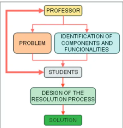
Al this point we start the design of the problems knowing the GIS components and the functionalities that will be interest-ing for the student’s. We can use the followinterest-ing process:
Figure 5: The problems design process. And the description of each one of these phases is the following one:
PHASE 1. - ANALYSIS OF ACTIVITIES: The process begins with the study of the activities or problems on those that it will be use the Geographical Information System.
PHASE 2. - COMPONENTS IDENTIFICATION: Once we known the activities and works that will be done using the GIS it is necessary to identify the simple components, the complexes and the attributes that will intervene in the administration and to characterize them.
PHASE 3. - TABLE OF FUNCTIONALITIES AND PROBLEMS: With the data obtained in the two previous phases it can get ready a double entrance table in which the listing of functionalities appears on the rows and the problems in the columns.
PHASE 4. - DESIGN OF PROBLEMS: In this phase, simultaneous with the previous one, they go getting ready the prob-lems stuffing the functionalities that we used in each one of them with the objective of going developing new probprob-lems until we have a collection that we can give to the students.
FUNCIONALITIES PROBLEM 1 PROBLEM 2 PROBLEM 3 … … …PROBLEMS
Functionality 1 • •
Functionality 2 • •
Functionality 3 •
… … …
CONCLUSIONS
This is only an example of a GIS course using PBL technique and on a e-learning concept but it is also an example of how the future will be and the possibilities we have to develop a future cooperation. The Universities of the European Union have a large group of GIS teachers with great experience. In a global world we can predict an important competence from third countries. We have experience and now we have a new opportunity to work together producing new competitive courses with new training techniques. Internet offers us a global classroom. e-learning can bring together teachers from any university from EU and we can develop new GIS courses using and joining our ideas, experience, and qualities.
REFERENCES
1. [CAL 92].- Calvo Melero, Miguel. (1992) “Sistemas de Información Geográfica Digitales. Sistemas Geomáticos”. IVAP-EUSKOIKER. Oñate. Spain.
2. [CEC 00].- Commission Of The European Communities (2000) “e-Learning. Designing tomorrow’s education”. Communication from the commission. Brussels 24.5.2000 COM(2000) 318 final.
3. [DAB 00].- Dabbagh, N., Jonassen, D., & Yueh, H. (2000). “Assessing a problem-based learning approach to an introductory instructional design course: A case study”. Performance Improvement Quarterly, 13(3), 60-83.
4. [GOR 01].- Gordon, P., Rogers, A., & Comfort, M. (2001). “A taste of problem-based learning increases achievement of urban minority middle-school students”. Educational Horizons, 79(4), 171-175.
5. [MEI 96].- Meier, S., Hovde, R., & Meier, R. (1996). « Problem solving: Teachers’ perceptions, content area models, and interdisciplinary connections”. School Science and Mathematics, 96, 230-237.
6. [SAG 00].- Sage, S. (2000). “A natural fit: Problem-based learning and technology standards”. Learning and Leading with Technology, 28(1), 6-12.
7. [TCH 96].- Tchudi, S., & Lafer, S. (1996). “The interdisciplinary teacher’s handbook: Integrated teaching across the curriculum”. Portsmouth, NH: Boynton/Cook.
8. [WAR 02].- Janet D. Ward and Cheryl L. Lee (2002). “A review of problem-based learning”. Journal of Family and Consumer Sciences Education, Vol. 20, No. 1, Spring/Summer