A S X A n n o u n c e m e n t | 1 9 O c t o b e r 2 0 2 0
Mineralisation Observed in Majority of Drill Holes at Oracle Ridge
•
Six drill holes completed and four logged in initial drilling campaign
•
Mineralisation observed in majority of drill holes expected to add to the resource
base as is the goal of this drilling campaign
•
8.4m of massive to semi-massive, mineralised magnetite skarn in WT-20-05
Potential new copper zone identified
•
Vein-hosted mineralisation in ‘Leatherwood’ granite increasing prospectivity of
this rock unit
•
Drilling advancement rate substantially exceeding expectations
•
Due to COVID-19 issues and increased exploration activity in the region, assay
turnaround time has moved out to 5-6 weeks
•
Drilling program extended following positive results observed in drill core and
recently completed capital raising
Eagle Mountain Mining Limited (ASX:EM2) (“Eagle Mountain”, the “Company”) is pleased to
provide an update on exploration activities at its 80% owned Oracle Ridge Mine Project (“Oracle
Ridge”) in Arizona.
It is Eagle Mountain’s intent to build a low-cost mining operation. This means increasing the
resource base both within the current mine and in the near-mine vicinity. To this end, diamond
drilling commenced at Oracle Ridge in early September and was designed primarily to target
extensions of the high-grade portions of the existing Mineral Resource Estimate (MRE).
Five of the six drill holes completed intersected skarn-hosted copper mineralisation.
Additionally, and of potentially great importance, is that mineralisation has been encountered
in the Leatherwood granite, which opens up the prospectivity of this rock unit.
This announcement provides a summary of visual observations on these first four holes which
have been logged. Samples have been submitted to the laboratory and assay results are
expected in the coming weeks.
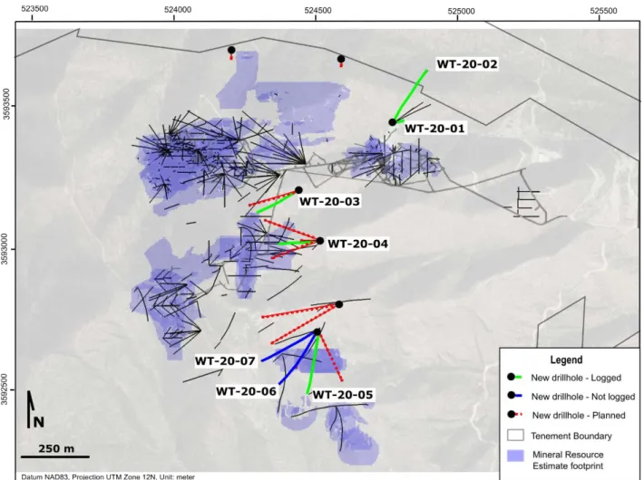
Figure 1 – Summary of currently completed and planned drillholes
Eagle Mountain Mining CEO Tim Mason commented:
“We are excited by what we have seen in the first six holes at Oracle Ridge and we are eagerly
awaiting assay results. As all the holes are located outside the existing mineral resource, any
positive results from the assays are likely to increase the quantity of the known mineralisation.
In addition, the mineralised zone within the ‘Leatherwood’ at the bottom of WT-20-05 is
particularly interesting as it changes our interpretation of the local geology and increases the
prospectivity of the area. Following the positive observations from the drill core, along with our
recently completed capital raise and conversion of options by our Managing Director, Charles
Bass I am pleased that we have extended our drilling program to at least December 2020. ”
Drill Hole Summary
Below is a summary of the four holes, WT-20-02 to WT-20-05, drilled and logged to date. All
holes were positioned to test potential mineralisation that is outside of the current known
resource. WT-20-01 was not completed as it hit an unexpected void and was terminated before
reaching its intended target.
WT-20-02
WT-20-02 was designed to test the eastern extension of mineralisation and the previously
untested Geesman Fault. The Geesman Fault is a major structure which bounds Oracle Ridge
to the north. Its relationship to copper mineralisation is still unclear.
The drill hole intersected several zones of sheared Leatherwood granite with only minor brittle
deformation. Once multi-element assays are received, an assessment of the geochemical
footprint of the structure will be completed to understand its potential role as a plumbing
system for the Oracle Ridge mineralisation and the likelihood of the structure to host economic
grade mineralisation.
WT-20-03
WT-20-03 was designed to test a poorly drilled area with potential for extensions of high-grade
copper intersections encountered in historical underground drilling and the
Leatherwood-sediments contact. Extension to the mineralisation have been intersected and further drilling
is required to establish continuity, tenor and thickness of the mineralisation between WT-20-03
and the historical underground holes.
WT-20-04
WT-20-04 was drilled to better assess the mineralisation true width that was encountered in a
nearby historical drill hole. WT-20-04 was extended at depth to also confirm intersections in a
historical hole in a scarcely drilled area of the deposit. Both zones were successfully intersected.
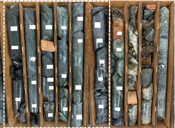
Figure 2 - WT-20-04, 186.4m down hole depth. Zone of semi-massive bornite and chalcocite within a
broader zone of mineralisation of approximately 9.6m (visual estimate). HQ core size is approximately
Figure 3 WT-20-04 ~294m downhole. Large blebs of bornite in mineralised skarn. HQ core size is
approximately 15 cm length
WT-20-05
WT-20-05 was drilled to test the western extension of the mineralisation in historical holes. The
drill hole was also extended at depth to test the contact between the limestone sediments and
Leatherwood granite intrusive. The drill hole successfully intersected both targets with
abundant copper sulphides observed.
The thickness of mineralisation at the Leatherwood-limestone contact prompted a
reassessment of the geological model and the planning of two additional drill holes to test the
northern extent of this zone.
Figure 4 - WT-20-05 – Fine grained chalcocite rich mineralisation observed within skarn over ~8.4m
A summary of the completed drill holes is provided in Table 1 below.
Table 1 Summary table of completed holes at Oracle Ridge
Hole ID Easting Northing Elevation Depth Azimuth Dip Logged
[m] [m] [m] [m] [°] [°] WT-20-01 524771 3593296 1908 73.2 078 -51 Abandoned WT-20-02 524771 3593296 1908 326.7 030 -47 Yes WT-20-03 524437 3593062 2102 335.3 240 -60 Yes WT-20-04 524513 3592882 2105 335.3 267 -58 Yes WT-20-05 524507 3592571 2096 401.4 187 -55 Yes WT-20-06 524507 3592571 2096 369.1 210 -47 No WT-20-07 524507 3592571 2096 342.3 237 -44 No
Drilling advancement rates
The Company is very pleased with the drilling performances achieved by the contractor Boart
Longyear. The LF-90 rig on site routinely recovers over 120 metre of core per 24 hours, under
normal drilling conditions, with the current daily record set at over 140 metres. These are
exceptional results and the Company would like to commend Boart Longyear and their
personnel on site for the professionalism and dedication shown so far.
Assay laboratory update
Due to the impact of COVID-19 and the recent resurgence in exploration activities in North
America, assay laboratories in the region are experiencing longer turnaround times than usual.
The Company has been monitoring the situation and will continue to assess the available
options to ensure assays results are received in the shortest possible timeframe.
Drill program
Following the positive visual observations in the drilling core, the Company has advised Boart
Longyear of its intent to continue drilling until at least the end of December 2020. Future holes
during this time will continue to test extensions to known mineralisation and follow up on new
mineralised areas.
For further information please contact:
Tim Mason
BEng, MBA, GAICD Chief Executive Officer tim@eaglemountain.com.au
Mark Pitts
B.Bus, FCA, GAICD Company Secretary
mark@eaglemountain.com.au
Jane Morgan
Investor and Media Relations
jm@janemorganmanagement.com.au
This Announcement has been approved for release by the Board of Eagle Mountain Mining Limited
COMPETENT PERSON STATEMENT
The information in this document that relates to Exploration Activities is based on information compiled by Mr Fabio Vergara and Mr Brian Paull who are both Members of The Australasian Institute of Mining and Metallurgy (MAusIMM) and have sufficient experience relevant to the activity which they are undertaking to qualify as a Competent Persons as defined in the 2012 Edition of the Australasian Code for Reporting of Exploration Results, Mineral Resources and Ore Reserves (JORC Code 2012). Mr Vergara is the Chief Geologist and Mr Paull Principal Geologist of Eagle Mountain Mining Limited and consent to the inclusion in this document of the information in the form and context in which it appears. Mr Vergara and Mr Paull hold shares and options in Eagle Mountain Mining Limited.
EAGLE MOUNTAIN MINING LIMITED
Eagle Mountain is a copper-gold explorer focused on the strategic exploration and development of highly prospective greenfields and brownfields projects in Arizona, USA.
Arizona is at the heart of America’s mining industry and home to some of the world’s largest copper discoveries such as Bagdad, Miami and Resolution, one of the largest undeveloped copper deposits in the world.
Follow the Company developments through our website and social media channels Website https://eaglemountain.com.au/
Twitter https://twitter.com/eagle_mining
JORC Code, 2012 Edition – Table 1 report
Section 1 Sampling Techniques and Data
(Criteria in this section apply to all succeeding sections.)
Criteria JORC Code explanation Commentary
Sampling techniques
• Nature and quality of sampling (eg cut channels, random
chips, or specific specialised industry standard measurement tools appropriate to the minerals under investigation, such as down hole gamma sondes, or handheld XRF instruments, etc). These examples should not be taken as limiting the broad meaning of sampling.
• Include reference to measures taken to ensure sample
representivity and the appropriate calibration of any measurement tools or systems used.
• Aspects of the determination of mineralisation that are
Material to the Public Report.
• In cases where ‘industry standard’ work has been done
this would be relatively simple (eg ‘reverse circulation drilling was used to obtain 1 m samples from which 3 kg was pulverised to produce a 30 g charge for fire assay’). In other cases more explanation may be required, such as where there is coarse gold that has inherent sampling problems. Unusual commodities or mineralisation types (eg submarine nodules) may warrant disclosure of detailed information.
• Targets were tested by diamond drilling
• No samples reported
Drilling techniques
• Drill type (eg core, reverse circulation, open-hole hammer,
rotary air blast, auger, Bangka, sonic, etc) and details (eg core diameter, triple or standard tube, depth of diamond tails, face-sampling bit or other type, whether core is oriented and if so, by what method, etc).
• Diamond drilling, HQ3 size. Downhole surveys are performed every
approximately 30.5m (100 feet). The core is oriented with a Boart Longyear Truecore system to allow measurement of structural information.
Drill sample recovery
• Method of recording and assessing core and chip sample
recoveries and results assessed.
• Measures taken to maximise sample recovery and ensure
• Core recoveries are recorded by the drillers at the rig and verified by Company’s personnel during core logging
Criteria JORC Code explanation Commentary
representative nature of the samples.
• Whether a relationship exists between sample recovery
and grade and whether sample bias may have occurred due to preferential loss/gain of fine/coarse material.
with a “triple tube” set up where two splits are inserted in the barrel to minimize core displacement and core loss.
• Not applicable. No samples reported.
Logging • Whether core and chip samples have been geologically
and geotechnically logged to a level of detail to support appropriate Mineral Resource estimation, mining studies and metallurgical studies.
• Whether logging is qualitative or quantitative in nature.
Core (or costean, channel, etc) photography.
• The total length and percentage of the relevant
intersections logged.
• A quick log is completed on site and detailed logging (geological and geotechnical) is performed at the Company’s logging facility in Tucson.
• Logging is both qualitative and quantitative in nature. Portable XRF and
magnetic susceptibility measurements are taken at regular intervals on the core. Core is photographed after mark up, before sampling, wet and dry
• 100% of the core is logged
Sub-sampling techniques and sample preparation
• If core, whether cut or sawn and whether quarter, half or all
core taken.
• If non-core, whether riffled, tube sampled, rotary split, etc
and whether sampled wet or dry.
• For all sample types, the nature, quality and
appropriateness of the sample preparation technique.
• Quality control procedures adopted for all sub-sampling
stages to maximise representivity of samples.
• Measures taken to ensure that the sampling is
representative of the in situ material collected, including for instance results for field duplicate/second-half sampling.
• Whether sample sizes are appropriate to the grain size of
the material being sampled.
• Not applicable. No samples reported.
Quality of assay data and laboratory tests
• The nature, quality and appropriateness of the assaying
and laboratory procedures used and whether the technique is considered partial or total.
• For geophysical tools, spectrometers, handheld XRF
instruments, etc, the parameters used in determining the analysis including instrument make and model, reading times, calibrations factors applied and their derivation, etc.
• Nature of quality control procedures adopted (eg
standards, blanks, duplicates, external laboratory checks) and whether acceptable levels of accuracy (ie lack of bias) and precision have been established.
Criteria JORC Code explanation Commentary
Verification of sampling and assaying
• The verification of significant intersections by either
independent or alternative company personnel.
• The use of twinned holes.
• Documentation of primary data, data entry procedures,
data verification, data storage (physical and electronic) protocols.
• Discuss any adjustment to assay data.
• Significant intersections have been verified by Company’s Principal Geologist
• No twinned holes drilled
• Logging and sampling data are collected using tablet computers and Logchief software to ensure data integrity. The data is transferred weekly to the Datashed database.
• No assay adjustment performed
Location of data points
• Accuracy and quality of surveys used to locate drill holes
(collar and down-hole surveys), trenches, mine workings and other locations used in Mineral Resource estimation.
• Specification of the grid system used.
• Quality and adequacy of topographic control.
• NAD83 Arizona State Plane Central (International feet). Data is presented in NAD83 UTM Zone 12N (meters)
• National Elevation Dataset. Horizontal resolution of approximately 10m and vertical resolution of 1m
• Drill holes are located with a hand-held GPS with an estimated horizontal accuracy of ±5m
Data spacing and
distribution
• Data spacing for reporting of Exploration Results.
• Whether the data spacing and distribution is sufficient to
establish the degree of geological and grade continuity appropriate for the Mineral Resource and Ore Reserve estimation procedure(s) and classifications applied.
• Whether sample compositing has been applied.
• The data spacing is insufficient to establish the degree of geological and grade continuity appropriate for Mineral Resource estimation
Orientation of data in relation to geological structure
• Whether the orientation of sampling achieves unbiased
sampling of possible structures and the extent to which this is known, considering the deposit type.
• If the relationship between the drilling orientation and the
orientation of key mineralised structures is considered to have introduced a sampling bias, this should be assessed and reported if material.
• The relationship between drilling orientation and orientation of key mineralised structures is yet to be determined
Sample security
• The measures taken to ensure sample security. • Core boxes are picked up at the rig by Company personnel and moved to the
Tucson logging facility. After logging the core is delivered by Company personnel to ALS’s Tucson facilities for cutting, sampling, sample preparation and assaying.
Audits or reviews
• The results of any audits or reviews of sampling
techniques and data.
Section 2 Reporting of Exploration Results
(Criteria listed in the preceding section also apply to this section.)
Criteria JORC Code explanation Commentary
Mineral tenement and land tenure status
• Type, reference name/number, location and ownership including
agreements or material issues with third parties such as joint ventures, partnerships, overriding royalties, native title interests, historical sites, wilderness or national park and environmental settings.
• The security of the tenure held at the time of reporting along with any
known impediments to obtaining a licence to operate in the area.
• The Oracle Ridge mine is located on Oracle Ridge and Marble Peak approximately 24 kilometers by air northeast of Tucson, Arizona, U.S.A. and is located in Sections 17, 18, 19 and 20 of Township 11 South, Range 16 East, Gila and Salt River Base and Meridian. The geographical coordinates are approximately Latitude 32º28' North, Longitude 110º41' West.
• The Oracle Ridge mine is 100% owned by Wedgetail Operations, an Arizona limited liability corporation controlled by Eagle Mountain Mining Ltd and its subsidiaries (80%) and Vincere Resource Holdings LLC (20%)
• The project consists of 57 patented mining claims covering approximately 364 hectares, 143 hectares of private land and 405 hectares of unpatented claims. The project has been recently expanded with the staking of 105 unpatented mining claims over two prospects named OREX and Red Hawk
• In 2009, the surface rights for the area necessary for potential mining access, processing facilities and offices have been secured by an industrial property lease. Under the Lease, Wedgetail Operations LLC leased from Marble Mountain the surface rights to the project for the purpose of carrying out its exploration, and potential development and mining. The lease has an initial term of three years and is renewable for nine additional extensions of three years each.
• 100% of the mineral rights are owned by Wedgetail Operations LLC
• There is a 3% net smelter returns royalty on the future sale of any metals and minerals derived from the project.
• The land tenure is secure at the time of reporting and there are no known impediments to obtaining permits to operate in the area.
Exploration done by other parties
• Acknowledgment and appraisal of exploration by other parties. • The Oracle Ridge Mining District was discovered in 1873. In 1881, a
18 tonne per day copper smelter was erected at nearby Apache Camp. The ore for this smelter was supplied from the Hartman, Homestake, Leatherwood, Stratton, Geesaman and other small mines in the area.
Criteria JORC Code explanation Commentary
• Phelps Dodge Copper Company (Phelps Dodge) entered the District in 1910 and undertook considerable development and exploration work.
• Continental Copper, Inc began exploring in the District in the 1950s. Continental leased the property in 1968 with an option to purchase and undertook a large exploration and development program. This was the first time there was a large scale look at the mineralisation.
• Union Miniere began a new exploration program in April 1980. In 1984, a feasibility study for a 1,814 tonne per day operation was completed.
• In October 1988, South Atlantic Ventures acquired Union Miniere's interest and entered into a 70-30 partnership with Continental to develop the mine. Minproc Engineers Inc. was contracted to
supervise the confirmatory metallurgical test work. A detailed design was started in November 1989 on a column flotation plant.
Construction of the facility commenced in April 1990 and the first ore was processed through the plant on March 3, 1991. The capacity of the mill was initially set at 771 tons per day.
• The mine closed in 1996 having produced an estimated 816,000 tonnes
• Between 2009 and 2015 the project was owned by Oracle Ridge Mining, a TSX-V listed company, which drilled approximately 130 surface and underground holes
Geology • Deposit type, geological setting and style of mineralisation. • The deposit is classified as copper dominated skarn. Minerals
representative of both prograde and retrograde skarn development are present, the former being represented by diopside and garnets, the later by epidote, magnetite and chlorite.
• Copper dominated mineralisation generally contain chalcopyrite and bornite. The deposits are most commonly associated with Andean-type plutons intruded in older continental-margin carbonate
sequences. The associated intrusive rocks are commonly porphyritic stocks, dikes and breccia pipes of quartz diorite, granodiorite, monzo-granite and tonalite composition, intruding carbonate rocks,
calcareous-volcanic or tuffaceous rocks. The deposits shapes vary from stratiform and tabular to vertical pipes, narrow lenses, and irregular zones that are controlled by intrusive contacts.
Criteria JORC Code explanation Commentary
• The copper rich skarn deposits at Oracle Ridge are found in conformable lens along the contact with the Leatherwood Granodiorite or associated with faults and shear zones which intersect the Leatherwood. These have acted as feeders into the reactive carbonate horizons. The later can form a “Christmas Tree” type shape
Drill hole Information
• A summary of all information material to the understanding of the
exploration results including a tabulation of the following information for all Material drill holes:
o easting and northing of the drill hole collar
o elevation or RL (Reduced Level – elevation above sea level in
metres) of the drill hole collar
o dip and azimuth of the hole
o down hole length and interception depth
o hole length.
• If the exclusion of this information is justified on the basis that the
information is not Material and this exclusion does not detract from the understanding of the report, the Competent Person should clearly explain why this is the case.
• See body of announcement
Data aggregation methods
• In reporting Exploration Results, weighting averaging techniques,
maximum and/or minimum grade truncations (eg cutting of high grades) and cut-off grades are usually Material and should be stated.
• Where aggregate intercepts incorporate short lengths of high grade
results and longer lengths of low grade results, the procedure used for such aggregation should be stated and some typical examples of such aggregations should be shown in detail.
• The assumptions used for any reporting of metal equivalent values
should be clearly stated.
• No data aggregation methods were applied.
• No metal equivalents reported
Relationship between mineralisation widths and intercept lengths
• These relationships are particularly important in the reporting of
Exploration Results.
• If the geometry of the mineralisation with respect to the drill hole
angle is known, its nature should be reported.
• If it is not known and only the down hole lengths are reported, there
should be a clear statement to this effect (eg ‘down hole length, true width not known’).
• All intervals reported are down hole length. True width are not known at this stage.
Criteria JORC Code explanation Commentary
Diagrams • Appropriate maps and sections (with scales) and tabulations of
intercepts should be included for any significant discovery being reported These should include, but not be limited to a plan view of drill hole collar locations and appropriate sectional views.
• See body of announcement
Balanced reporting
• Where comprehensive reporting of all Exploration Results is not
practicable, representative reporting of both low and high grades and/or widths should be practiced to avoid misleading reporting of Exploration Results.
• All exploration results obtained so far have been reported.
Other substantive exploration data
• Other exploration data, if meaningful and material, should be reported
including (but not limited to): geological observations; geophysical survey results; geochemical survey results; bulk samples – size and method of treatment; metallurgical test results; bulk density,
groundwater, geotechnical and rock characteristics; potential deleterious or contaminating substances.
• No other meaningful and material exploration data beyond this and previous market releases
Further work • The nature and scale of planned further work (eg tests for lateral
extensions or depth extensions or large-scale step-out drilling).
• Diagrams clearly highlighting the areas of possible extensions,
including the main geological interpretations and future drilling areas, provided this information is not commercially sensitive.
• Further work will include interpretation of logging and assay results when they become available. Additional drill holes will be completed at Oracle Ridge in the coming weeks.