LAND-SURFACE
SUBSIDENCE
IN
THE HOUSTON-GALVESTON
REGION,
TEXAS
Robert K. GABRYSCH? United States Geological Survey ABSTRACT
In the Houston-Galveston region of Texas, the principal cause of land-surface subsi- dence is the lowering of pressure heads due to the removal of water and oil from subsurface strata. This paper emphasizes the effects of removal of water.
The region is underlain by a thick section of unconsolidated lenticular deposits of sand and clay. Clays separating beds of sand retard the vertical movement of water, thus creating artesian conditions within the aquifers. The ratio of sand to clay, which is a major factor controlling the degree of compaction, varies from place to place in the aquifers. Reduction of pressure due to withdrawal of water causes additional load to be transferred to the skeleton of the aquifer system, thus causing compaction.
As much as 5 feet of subsidence has occurred in the Houston-Galveston region between 1943 and 1964, and as much as 200 feet of water-level decline has occurred during the same period. The rate of subsidence increased from about 0.2 foot prr year during the 1954-59 period to about 0.24 foot per year during the 1959-64 period. The decline in
water levels increased from about 4 feet per year to about 7 feet per year in those same periods.
RESUME
Dans la région de Houston-Galveston, Texas, la raison principale de l’affaissement du terrain naturel est ia réduction de la hauteur piézométrique dans les couches souter- raines du fait du pompage de puits à pétrole, et de puits à eau. On examine en particulier ici les résultats de l’extraction de l’eau souterraine.
A partir du terrain naturel on rencontre successivement d’innombrables couches ou des lentilles de sable et d’argile. Les couches sont discordantes, d’épaisseur variable, et plus ou moins compactes. L’inconvénient majeur pour le débit de l’eau et pour la perméabilité en direction verticale est constitué par les couches d’argile. Dans les couches de sable se trouvent des nappes d’eau captives. La distribution quantitative des sables et des sables argileux est un des facteurs très importants, qui peut influencer sérieuse- ment le degré de compactage des couches. La réduction de la pression hydrostatique dans les couches sablonneuses par le pompage de l’eau souterraine, est telle que la charge et ia contrainte à ia compression sur les couches est cause de compaction et d’affaissement sensibles.
INTRODUCTION
The phenomenon of land-surface subsidence has been attributed(Po1and and Davis, 1956, pp. 294-295) to: (i) Loading of the land surface, (2) vibrations at or near the land surface, (3) compaction due to irrigation, (4) solution due to irrigation, (5) drying and shrinkage of deposits, (6) oxidation of organic materials, (7) decline of the water table, (8) decline of artesian pressure in water sands, (9) decline of pressure in oil zones due to the removal of oil and gas, and (10) tectonic movements.
In the Houston-Galveston region, the principal cause of subsidence is the lowering of pressure heads due to the removal of water and oil. The other possible causes are either insignificant or ineffective.
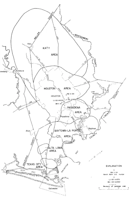
The Houston-Galveston region, as described in this report, includes all of Harris and Galveston Counties, and parts of Brazoria, Fort Bend, Waller, Montgomery, Liberty and Chambers Counties.
1. Publication authorized by the Director, U.S. Geological Survey. 2. Hydrologist; Houston, Texas.
The Houston-Galveston region is underlain by a thick section of unconsolidated lenticular deposits of sand and clay. Pertinent geologic formations in this section are, from oldest to youngest: Fleming Formation of Miocene age, Goliad Sand of Pliocene age, Willis Sand of Pliocene (?) age, and Lissie Formation and Beaumont Clay of Pleistocene age. The for- mations crop out in bands roughly parallel to the coast and dip toward the coast at an angle greater than the slope of the land surface.
The geologic formations compose the principal aquifers of the region, the Evangeline aquifer and the Chicot aquifer. Within these aquifers, the interbedded sands and clays are saturated with water almost to the land surface, but the clays retard the vertical move- ment of water, creating artesian conditions within the aquifers.
Withdrawal of water from the artesian aquifers results in an immediate decrease in hydraulic pressure, which partially supports the weight of the overburden. With reduction in pressure, an additional load is transferred to the skeleton of the aquifers, and a pressure difference between the sands and clays causes water to move from the clays to the sands. Most of this process of the sediment compaction takes place in the clays. Because the clays are mostly inelastic, the compaction is permanent.
The ratio of sand to clay, which is a major factor controlling the degree of compaction, varies from place to place in the aquifers. At the western edge of the region, the aquifers contain from 60 to 70 percent sand and from 30 to 40 percent clay. The percentage of clay increases downdip. Near the southern part of Harris County and the northern part of Galveston County, from 50 to 60 percent of the sediment is clay.
The clay-mineral assemblage
-
montmorillonite, illite, and kaolinite -in the Houston- Galveston region, is similar to the assemblages found in the two major areas of subsidence in the San Joaquin Valley of California. Montmorillonite is the major clay-mineral consti- tuent of the material finer than 2 microns, making up at least half of the assemblages in ali samples examined.PUMPAGE AND D E C L I N E OF WATER LEVELS
Prio to 1954, nearly all water supplies were obtained from ground water. In 1954, water from Lake Houston on the San Jacinto River became available fort part of the industriai and municipal needs. The use of surface water temporarily lessened the ground-water draft, but the increase in water use and greater demands on the ground-water supply have required the construction of additional wells.
The ground-water draft in 1964 was 411 mgd (million gallons per day) compared to 354 mgd in 1953. Thus the Houston-Galveston region used 57 mgd more ground water in 1964 than in 1953 even with tha added Lake Houston supply of about 100 mgd. P u m - page by the city of Houston for public supply alone increases at the rate of about 5 mgd per year.
Ground-water is being extracted in the six major areas shown in figure 1. The average daily ground-water pumpage in 1964 in each area was as follows:
Pumpage area Average daily pumpage (million gallons per day)
Houston 132 Pasadena 90 Baytown-La Porte 26 Texas City 1 1 Alta L o m a 1 1 Katy 141
Land-surface subsiding in rhe Houston- Galveston region, Texas
Land-surface subsiding in the Houston- Galveston region, Texas
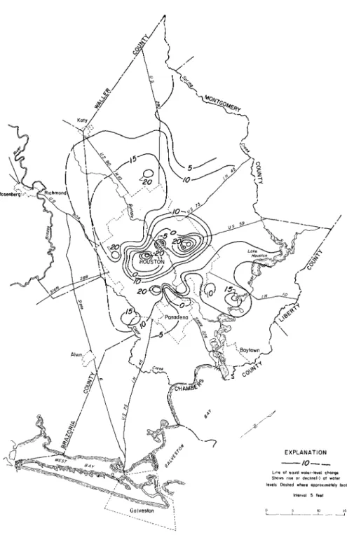
Figures 2, 3, and 4 show the changes in water levels in wells tapping the heavily pum- ped sands in the Houston-Galveston region for the periods 1954-59,1959-64, and 1963-64, respectively. These periods correspond to the periods of relevelling of lines of bench marks by the U. S. Coast and Geodetic Survey. In the Pasadena area, where ground-water with- drawals are heavily concentrated, the decline of water levels in wells has been about 200 feet during the period 1943-64.
RATE AND EXTENT OF S U B S I D E N C E
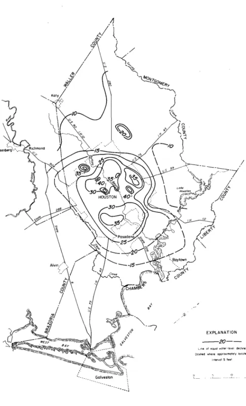
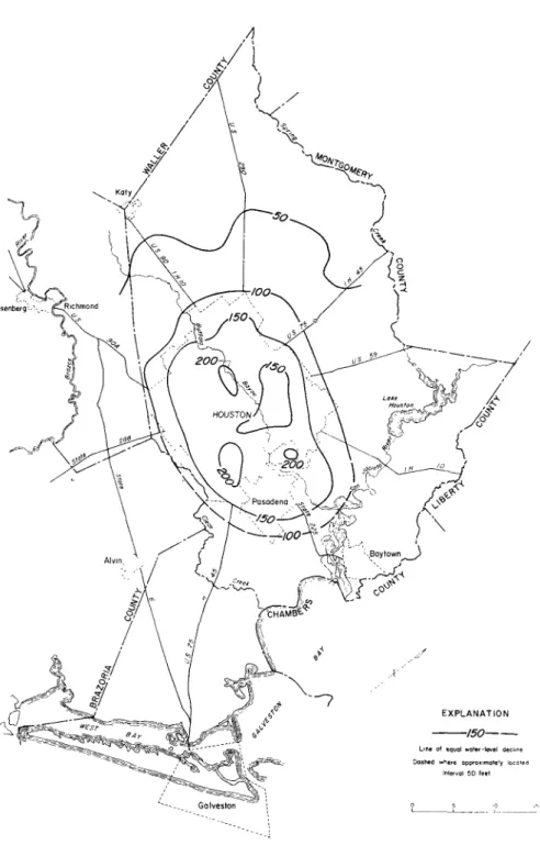
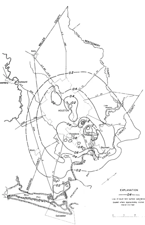
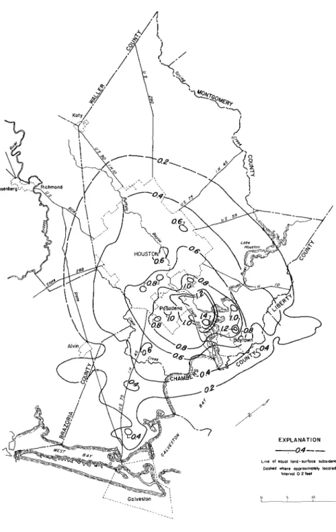
Figures 5, 6, and 7, show the amount of subsidence in the Houston-Galveston region for the period 1954-59, 1959-64, and 1943-64. The maps are based on the results of the U.S. Coast and Geodetic Survey levelling program, supplemented by data from local industries.
A
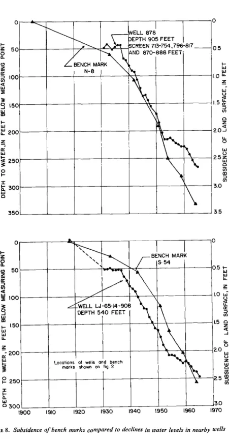
comparison of the water-level and subsidence maps shows a close correlation between water-level or pressure-head declines and land-surface subsidence. The maximum rate of subsidence increased from about 0.2 foot per year during the period 1954-59 to about 0.24 foot per year during the period 1959-64. The decline map (fig. 2) for the period 1954-59 shows much smaller declines (and recovery) than does the decline map for the succeeding five years (fig. 3).Because of a lag between lowering of the piezometric head and compaction, correlation between subsidence and pressure-head decline may not be obvious for short periods of time. This lag is illustrated by the graphs in figure 8 which show declines in water levels in wells compared to subsidence of the land surface. The graphs show that the rate of decline in wafer levels decreased from 1954 to 1959, but the rate of subsidence did not decrease proportionately during the same period.
Figure 8 shows, since 1943, about 1.3 feet of subsidence for bench mark N-8 per 100 feet of water-level decline in well LJ-65-14-878 nearest the city of Pasadena and about 1.1 feet of subsidence for bench mark S-54 per 100 feet of water-level decline in well LJ-65-14-908 in the area farther northwest of Pasadena. This difference in the relationship between subsidence and pressure decline is due to the amount of clay present in the inter- val affected by the decline in pressure; the greater the percentage of clay, the greater the amount of subsidence.
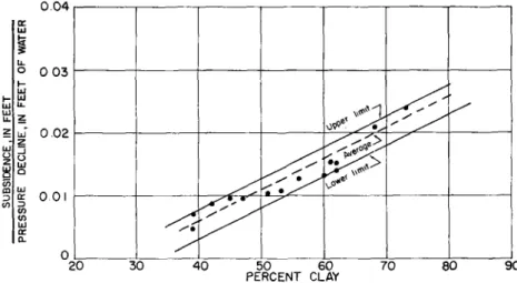
Figure 9 shows the general relationship in the Houston-Galveston region between the percentage of clay and the amount of subsidence due to pressure-head decline. The per- centage of clay was determined from interpretation of electrical logs; the pressure-head decline was determined from measured water levels in wells; and subsidence values were taken from changes in nearby bench-mark elevations.
Records from compaction recorders in the Houston-Galveston region are in-sufficient to relate compaction to depth. Most of the compaction probably is occuring near surface because near-surface clays have been subjected to less overburden than deeper clay. In a test in California, Poland and Ireland (1965) found that only about 0.01 feet of a total of 1.2 feet of compaction occured below a depth of 1,930 feet.
EFFECTS OF SUBSIDENCE
The detrimental effects of land-surface subsidence are: (1) Structural damage, probably due to faulting, that has cracked buildings and disrupted pavements; (2) damage to well casings; and (3) submergence of coastal lowlands.
Winslow and W o o d (1959) suggested two beneficial effects of subsidence: (1) About one-fifth of the water pumped from wells in the region has come from compaction of clay, and (2) subsidence has deepened the Houston Ship Channel and thus reduced the amount of dredging required to keep the channel at the required depth.
Land-surface subsiding in the Houston- Galveston region, Texas
A
Land-surface subsiding in the Houston- Galveston region, Texas
Land-surface subsidence in the Houston- Galveston region, Texas
K W a' 3
8
003 I-z
w-o
.o2 UJ UJ W œ a O 20 90FIGURE 9. Relation between percent clay and subsidence due to pressure decline
CONCLUSIONS
Pumping of ground-water in the Houston-Galveston region will increase and subsidence will continue until additional surface-water sources are available.
After additional surface-water supplies become available, it is likely that there will be a decrease in the rate of ground-water withdrawal and possibly a stabilization of the pres- sure levels in the heavily pumped sands. The total amount of subsidence willdepend upon the ultimate pressure-levei decline which, in turn, is dependent upon the ground-water withdrawals.
REFERENCES
POLAND, J.F., and DAVIS, G.H. (1956): Subsidence of the land surface in the Tulare-Wasco (Delano) and Los Banos-Kettleman City areas, San Joaquin Valley, California, Am. Geophys.
Union Trans., vol. 37, no. 3, pp. 281-296.
POLAND, J. F. and IRELAND, R.L. (1965): Shortening and protrusion of a well casing du to compac- tion of sediments in a subsiding area in California, U.S. Geol. Survey Prof. Paper 525-B. WINSLOW, A. G. and DOYEL, W . W. (1954): Land-surface subsidence and its relation to the with-
drawal of ground water in the Houston-Gaiveston region, Texas, Econ. Geology, vol. 49, no. 4, WINSLOW, A.G. and WOOD, L.A. (1959): Relation of land subsidence to ground-water with- drawals in the upper Gulf Coast region, Texas, Mining Eng., October. pp. 1030-1034; Am. Inst. Mining Metall. Petroleum Engineers Trans., vol. 2 14.