FM 3-34.331
HEADQUARTERS, DEPARTMENT OF THE ARMY
i
Field Manual
Headquarters
No. 3-34.331
Department of the Army
Topographic Surveying
Contents
Page
PREFACE ... vii
Chapter 1 MISSIONS, OPERATIONS, AND DUTIES...1-1
Survey Missions ...1-1 Survey Operations ...1-3 Survey-Personnel Duties ...1-9 Fieldwork...1-11 Office Work ...1-15 Survey Communication ...1-17
Chapter 2 PROJECT PLANNING ...2-1 Section I - Evaluation and Scheduling ...2-1
Project Requirements...2-1 Unit Capabilities ...2-2 Accuracy Constraints ...2-3 Milestones ...2-3 Administrative Support ...2-5 Logistics Support...2-6
Section II - Information-Gathering Trips ...2-8
Initial Site-Visitation Trip...2-8
DISTRIBUTION RESTRICTION: Approved for public release; distribution is unlimited.
*This Field Manual (FM) supersedes FM 5-232, 27 September 1989, and Technical Manuals (TMs) 5-232, 1 June 1971, and 5-237, 30 October 1964. It also supersedes DA Forms 1904, 1 February 1957; 1906, 1 February 1957; 1908, 1 February 1957; 1910, 1 February 1957; 1912, 1 February 1957; 1913, 1 February 1957; 1919, 1 February 1957; 1926, 1 February 1957; 1946, 1 February 1957; 1950, 1 February 1957; 1951, 1 February 1957; 1952, 1 February 1957; 1961, 1 October 1964; 1964, 1 February 1957; 2840, 1 October 1964; 2842, 1 October 1964; 2843, 1 October 1964; 2844, 1 October 1964; 2845, 1 October 1964; 2846, 1 October 1964; 2848, 1 October 1964; 2849, 1 October 1964; 2851, 1 October 1964; 2852, 1 October 1964; 2853, 1 March 1968; 2858, 1 March 1968; 2859, 1 March 1968; 2860, 1 October 1964; 2861, 1 October 1964; 2862, 1 October 1964; 2865, 1 March 1968; and 4727, 1 September 1978.
Washington, DC, 16 January 2001
FM 3-34.331
ii
Page Administrative-Recon Trip ... 2-9 Project-Visitation Trip ... 2-9
Section III - Project Execution ... 2-9
Chapter 3 SURVEY RECON ... 3-1 Section I - Recon Fundamentals ... 3-1
Recon Requirements ... 3-1 Recon-Party Composition... 3-2
Section II - Recon Phases ... 3-3
Office Recon ... 3-3 Field Recon ... 3-4 Recon Reports... 3-16
Chapter 4 DATUMS, GRIDS, AND COORDINATE REFERENCES ... 4-1
Datums ... 4-1 Grids ... 4-3 Coordinate References... 4-6
Chapter 5 CONVENTIONAL SURVEY-DATA COLLECTION... 5-1 Section I - Fundamentals ... 5-1
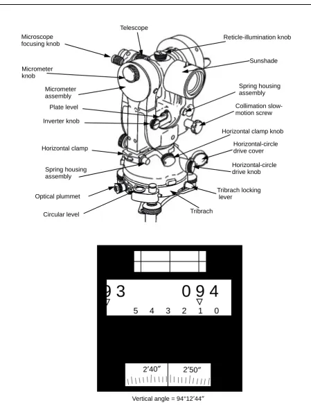
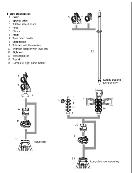
Angle Determination ... 5-1 Distance Measurement... 5-13 Electronic Total Stations ... 5-15
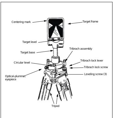
Section II - Targets ... 5-16
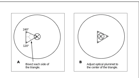
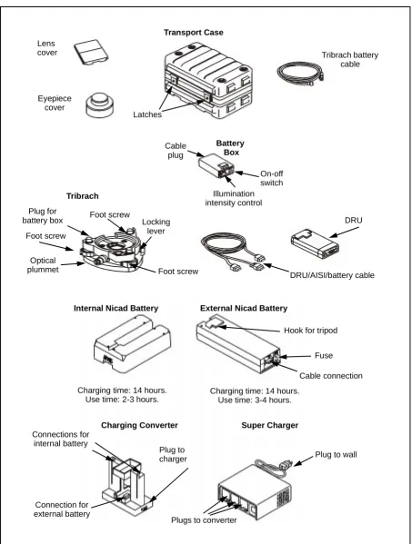
Optical-Theodolite Target Set... 5-16 AISI Target Set ... 5-17 Target Setup ... 5-19 Lighted Target Sets ... 5-19 Target and Tribrach Adjustment ... 5-20 Signals ... 5-21
Section III - AISI ... 5-24
iii Instrument Maintenance...5-29
Section IV - CAD Interface ...5-30
Total-Station Data Collection and Input ...5-30 Plotting ...5-31
Chapter 6 TRAVERSE...6-1
Starting Control ...6-1 Open Traverse ...6-1 Closed Traverse ...6-1 Fieldwork...6-2 Traverse Stations ...6-3 Traverse-Party Organization ...6-4 Azimuth Computations ...6-4 Azimuth-Bearing Angle Relationship...6-5 Coordinate Computations ...6-6 Accuracy and Specifications ...6-7
Chapter 7 DIFFERENTIAL LEVELING ...7-1 Section I - Instruments and Equipment ...7-1
Automatic Levels...7-1 Digital Levels...7-1 Optical-Micrometer Levels ...7-2 Leveling Rods and Accessories ...7-2 Instrument Testing and Adjustment ...7-2
Section II - Precise Leveling Procedures ...7-5
Recon ...7-5 DE Determination...7-5 Field-Party Composition ...7-6 Data Recording ...7-6 C-Factor Determination ...7-8 Center-Wire Adjustment ...7-9 SIF Determination ...7-9
Chapter 8 NAVSTAR GPS ...8-1 Section I - GPS Overview ...8-1
FM 3-34.331
iv
Page
Section II - Absolute Positioning... 8-5
Absolute-Positioning Accuracies ... 8-5 Pseudoranging ... 8-5 Absolute-Positioning Error Sources... 8-6 User Equivalent Range Error... 8-9 Accuracies ... 8-9
Section III - Differential Precise Positioning ... 8-14
Code-Pseudorange Tracking... 8-14 Carrier-Phase Tracking ... 8-15 Vertical Measurements ... 8-17 Differential Error Sources ... 8-18 Differential Accuracies ... 8-18
Section IV - Precise-Positioning Survey Planning ... 8-19
Project-Control Accuracy ... 8-20 Network-Design Factors ... 8-21 Network Design and Layout ... 8-28 GPS-S Techniques ... 8-31
Section V - Precise-Positioning Survey Conduct ... 8-35
Basic GPS-S Procedures ... 8-35 Absolute Positioning ... 8-36 Differential Positioning ... 8-37 DGPS Carrier-Phase Horizontal-Positioning Surveys ... 8-39 Static Surveying... 8-40 Stop-and-Go Kinematic Surveying ... 8-42 Kinematic Surveying ... 8-43 Pseudokinematic Surveying ... 8-44 Rapid-Static Surveying ... 8-45 OTF/RTK Surveying ... 8-45
Section VI - Precise-Positioning Survey-Data Processing ... 8-46
Processing Techniques ... 8-46 Baseline Solution by Linear Combination ... 8-47 Baseline Solution by Cycle-Ambiguity Recovery ... 8-49 Data Processing and Verification ... 8-49 Loop-Closure Checks ... 8-51 Data Archival ... 8-54
Section VII - Precise-Positioning Survey Adjustments... 8-54
v Survey Accuracy ...8-55 Internal Versus External Accuracy ...8-57 Adjustments ...8-58 Evaluation of Adjustment Results ...8-66 Final-Adjustment Reports...8-68
Chapter 9 ARTILLERY SURVEYS...9-1
US Army FA ...9-1 ADA...9-2 Survey Planning ...9-3
Chapter 10 AIRFIELD-OBSTRUCTION AND NAVAID SURVEYS ...10-1
Airport Obstruction Charts and NAVAID Surveys ...10-1 FAA and FAR Standards...10-2 Airfield-Data Accuracy Requirements ...10-7 Reporting...10-8
Chapter 11 REPORTS, BRIEFINGS, AND OPERATION ORDERS...11-1 Section I - Reports ...11-1
General ...11-1 ISVT Report ...11-2 Recon Report ...11-3 Progress Report ...11-6 End-of-Project Report ...11-6 Incident Report ...11-7 Report Disposition ...11-8
Section II - Briefings ...11-8
Impromptu Briefing ...11-8 Deliberate Briefing...11-8 Briefing Procedures...11-11
Section III - Survey SOP and Supporting Annexes ...11-13
Appendix A MENSURAL CONVERSION CHARTS... A-1
Appendix B CONTROL-SURVEY STANDARDS ... B-1
FM 3-34.331
vi
Page
Appendix C BASIC SURVEY COMPUTATIONS...C-1
Computation of a Two-Point Intersection ...C-1 Computation of a Grid Traverse and Side Shots ...C-7 Computation of a C-Factor ...C-24 Computation of a Level Line ...C-28
vii
This FM is a guide for military occupational specialty (MOS) 82D (Topographic Surveyor). It provides techniques not found in any commercial text concerning the precise determination of position, azimuth, or elevation of a point. Additionally, this publication describes and standardizes procedures for performing recons, preparing station descriptions, and reporting and briefing of survey projects.
The material in this manual is applicable, without modification, to all geodetic survey projects in all environments (prebattle, conventional war [nuclear and nonnuclear], low intensity conflicts, and postbattle). The contents comply with Army doctrine and international precision surveying practices. This manual does not provide previously published surveying doctrine or theory and may be supplemented with commercially available texts or previous editions of technical literature.
Appendix A contains mensural conversion charts.
The proponent of this publication is HQ, TRADOC. Send comments and recommendations on Department of the Army (DA) Form 2028 directly to United States (US) Army Engineer School (USAES), Attention: ATSE-DOT-DD, Directorate of Training, 320 Engineer Loop, Suite 336, Fort Leonard Wood, Missouri 65473-8929.
Missions, Operations, and Duties 1-1
Chapter 1
Missions, Operations, and Duties
Surveyors determine horizontal and vertical distances between objects,
measure angles between lines, determine the direction of lines, and
establish points of predetermined angular and linear measurements. After
completing field measurements, surveyors use these measurements to
compute a final report that is used for positioning by field artillery (FA),
air-defense artillery (ADA), aviation, intelligence, communications, or
construction control points. Appendix B summarizes the standards for
control surveys, Appendix C details the recommended procedures for basic
survey computations, and Appendix D includes a list of survey forms.
SURVEY MISSIONS
1-1. Army topographic surveyors support multiple types of survey missions. These missions can be peacetime or wartime oriented.
SUPPORT DEPLOYABLE WEAPONS SYSTEMS
1-2. Army topographic surveyors support FA and ADA deployable weapons systems by acquiring position and azimuth data as follows:
• FA. FA is a primary user of precise positioning and orientation
information in a wartime environment. Topographic-survey support is provided to the multiple-launch rocket-system (MLRS) units, the corps’s general-support (GS) units, and other nondivisional assets in the corps area according to FM 6-2. FA requires that topographic surveyors provide monumented survey control points (SCPs) (horizontal and vertical) and azimuthal references for conventional and inertial FA survey teams. FA sometimes requires topographic surveyors to augment FA survey sections.
• ADA. ADA requires positioning and orientation information for ADA
systems. ADA and FA have an agreement that FA surveyors (MOS 82C) will provide direct ADA survey support.
SUPPORT THE NATIONAL IMAGERY AND MAPPING AGENCY
1-2 Missions, Operations, and Duties
provides correlated World Geodetic System (WGS) 1984 (WGS-84) airfield surveys and geographical and aeronautical database information that are needed to support the aviation approach requirements. NIMA also determines transformation parameters between geodetic systems. In many areas of the world, the transformation parameters are uncertain or unreliable. During times of conflict, Army topographic surveyors may be required to collect data to enable NIMA to better formulate these transformation parameters.
SUPPORT THE US ARMY AERONAUTICAL SERVICES AGENCY
1-4. The US Army Aeronautical Services Agency (USAASA) requires periodic airfield and navigational-aid (NAVAID) surveys and airport obstruction charts (AOCs) according to Army regulation (AR) 95-2. These surveys are extensive field-survey operations that provide aeronautical and other information to support a wide range of National Airspace System (NAS) activities. AOC surveys provide source information on—
• Position. • Azimuth. • Elevation.
• Runways and stopways. • NAVAIDs.
• Federal Aviation Regulation (FAR), Part 77 (FAR-77) obstructions. • Aircraft movement and apron areas.
• Prominent airport buildings.
• Selected roads and other traverse ways.
• Cultural and natural features of landmark value. • Miscellaneous and special request items.
1-5. The positioning and orientation information for NAVAIDs is required to certify the airfield instrument-landing approaches. AOC surveys also establish geodetic control in the airport vicinity, consisting of permanent survey marks accurately connected to the National Spatial Reference System (NSRS). This control and the NSRS connection ensure accurate relativity between surveyed points on the airport and between these points and other surveyed points in the NAS, including the navigation satellites.
SUPPORT THE US AIR FORCE
1-6. The US Air Force (USAF) requires positioning and orientation data for the initialization of Inertial Navigation Systems (INSs), INS test pedestals, NAVAIDs, and compass roses. The USAF relies on NIMA to satisfy all of its positioning and orientation requirements. Army topographic surveyors are currently assigned to assist NIMA in establishing survey control for the USAF.
SUPPORT THE US ARMY INTELLIGENCE AND SIGNAL ELEMENTS
FM 3-34.331
Missions, Operations, and Duties 1-3
• Accuracy. The accuracy requirement for intelligence and signal
elements is similar to the accuracy expressed by FA and ADA. In many cases, intel ligence and si gna l units c an use the SC Ps established for FA and ADA.
• Frequency and timeliness. The number of SCPs and the timeliness
are dependent on the battlefield and the mission.
• Distribution. This survey information is distributed to each
intelligence and signal battalion’s operations section, Operations and Training Officer (US Army) (S3). Topographic surveyors are responsible for notifying the S3 of the various datums within the area of operation (AO). In addition, topographic surveyors provide the S3 with the necessary parameters and instructions on how to transform local coordinates to a predefined common grid (for example, WGS 84).
SUPPORT JOINT-LEVEL MISSIONS
1-8. During joint-level operations, topographic surveyors may be tasked to perform a number of different missions. Topographic surveyors are capable of providing support to allied nations for any of the aforementioned defined areas.
SUPPORT OTHER TOPOGRAPHIC MISSIONS
1-9. These other topographic missions are defined in AR 115-11, FM 5-105, unit table(s) of organization and equipment (TOE), and directives from higher headquarters (HQ). These missions—
• Provide precise positioning to support the updating of the MOS 81T (Terrain Analyst) database.
• Support construction surveyors (when projects require real-world coordinates).
• Establish and extend basic control for field surveys.
• Allow survey data and station description cards to be forwarded to NIMA, the organization’s survey information center (SIC), and collocated terrain-analyst teams (upon request).
SURVEY OPERATIONS
1-4 Missions, Operations, and Duties
SURVEY TYPES
1-11. In plane surveys, all points are referenced to a flat plane with curvature wholly or mostly ignored. In geodetic surveys, all established points are referenced to the curved surface of a spheroid and, in all computations, the effect of curvature is computed.
Plane Survey
1-12. Plane surveys ignore the actual shape of the earth and apply the principles of plane geometry and trigonometry. These surveys are treated as if the measurements were made on a flat plane, with all lines being straight. When the survey area is less than 250 square kilometers and less accuracy is needed, curvature can be ignored. Most localized construction projects (highway and railroad) and boundary projects use plane surveys.
Geodetic Survey
1-13. Geodetic surveys take into account the size and shape of the earth. Since the stations in geodetic surveys are routinely spaced over extended distances, more precise instruments and techniques are required than for plane surveys. All observations are made on the actual curved surface of the earth and this curvature is corrected through computations.
SURVEY METHODS
Conventional Survey
1-14. Topographic surveyors use theodolites, levels, and distance measuring equipment (DME). The automated integrated survey instrument (AISI) provides topographic surveyors with the capability to extend control through the use of a total station.
GPS Survey
1-15. The NAVSTAR GPS is capable of determining accurate positional, velocity, a nd timing information. The GPS provides positional and navigational data to civilian and military communities in the form of two positional services. The Standard Positioning Service (SPS) encompasses the civilian user and the US Coast Guard (USCG). When using a single GPS receiver (absolute positioning), SPS users are denied the high-accuracy, instantaneous positioning capability of the GPS. The Precise Positioning Service (PPS) consists of military users and authorized representatives. PPS users can obtain high-accuracy, instantaneous positioning if the receiver is capable of accepting the necessary cryptologic variables.
FM 3-34.331
Missions, Operations, and Duties 1-5
• Absolute positioning. Absolute positioning uses a single GPS
receiver and does not require known survey control. Absolute positions can provide instantaneous (real-time) or postprocessed positions. Known survey control is unreliable or nonexistent in immature theaters. Topographic surveyors can establish SCPs by using absolute positioning.
• Differential positioning. Differential positioning uses two or more
GPS receivers. One GPS receiver (reference receiver) is resident over a known SCP. The remaining receivers (remote receivers) are used to position points of interest. Differential positioning can be performed in real time or through postprocessing. If real-time positioning results are required, a communications link that is capable of transmitting digital data must be established at the reference- and remote-receiver locations. This method supports distances up to 100 kilometers between the reference and remote stations. The engineer battalions (topographic) within the Army have PPS GPS receivers that are capable of real-time and postprocessed differential positioning and provide relative accuracy of approximately 1 centimeter.
1-17. The accuracy of GPS-S is dependent on the user’s equipment (precise lightweight GPS receiver [PLGR]) and the surveying method employed (absolute real-time or differential). Topographic surveyors have standardized PPS GPS receivers. These receivers have improved the efficiency and productivity of topographic surveyors and have provided the Defense Mapping School (DMS) and the USAES a background on the training, operational, and research and development requirements that are necessary to successfully field the GPS. The new GPS-S provides adequate absolute-positioning results and is designed to provide protection in a jamming/spoofing environment. The requirement for a PPS GPS receiver that is capable of performing DGPS when using the military’s authorized, encrypted pseudorandom noise (PRN) code (Y-code) has been met. This receiver sa tisfies the positional accuracy requirements of the Army, the Department of Defense (DOD), and joint-level commands.
SURVEY CLASSIFICATIONS
1-18. Topographic surveyors are capable of conducting and supporting a wide variety of surveys. Surveys are classified as follows:
• Artillery. • Basic control. • Satellite. • Construction.
• Airfield engineering and NAVAID. • Hydrographic.
• Field classification and inspection. • Land.
1-6 Missions, Operations, and Duties
Artillery Surveys
1-19. Artillery surveys are conducted to determine the relative positions of weapons systems to targets. These surveys do not require the accuracy of geodetic-surveying techniques despite the relatively large areas and long distances. The requirements, methods, and techniques used by military FA surveyors are detailed in FM 6-2 and Chapter 11 of this manual. ADA weapon systems require accuracies that are obtainable only from geodetic-surveying techniques.
Basic-Control Surveys
1-20. Basic-control surveys provide horizontal and/or vertical positions of points. Supplementary surveys may originate from and can be adjusted to these surveys. The basic-control survey of the US provides geographic positions and plane coordinates of triangulation/traverse stations and the elevations or benchmarks (BMs). This information is used as the basis for the control of the US national topographic survey; the control of many state, city, and private surveys; and hydrographic surveys of coastal waters. The techniques and methods used by military geodetic surveyors are discussed in this manual.
Satellite Surveys
1-21. Satellite surveys determine high-accuracy, three-dimensional (3D) point positions from signals received by NAVSTAR GPS satellites. GPS-derived positions may be used to provide primary reference-control monument locations for engineering and construction projects from which detailed site plans, topographic mapping, boundary demarcation, and construction-alignment work may be performed using conventional-surveying instruments and techniques.
Construction Surveys
1-22. Construction surveys provide data for planning and cost estimating. This data is essential to locate or lay out engineering works and is recorded on engineer maps. Plane surveys are normally used for construction projects. The methods and techniques used by military construction surveyors are detailed in FM 5-233.
Airfield-Engineering and NAVAID Surveys
1-23. Airfield-engineering and NAVAID surveys are used to determine any combination of the following:
• The location of obstacles within 10 nautical miles of an airfield center. • The dimensions of runways and taxiways, the height of flight towers,
and NAVAIDs.
• The safe approach angles to runways and the minimum, safe glide angle.
• The elevation of the barometer on an airfield.
FM 3-34.331
Missions, Operations, and Duties 1-7
• The requirements of the Federal Aviation Administration (FAA), United States Army Aeronautical Services Agency USAASA, or equivalent military activity.
• The information used to assist a military-aircraft crash or disaster incident investigation.
Hydrographic Surveys
1-24. Hydrographic surveys are made on large bodies of water to determine channel depths for navigation and the location of rocks, sandbars, lights, and buoys. In rivers, these surveys are made to support flood-control projects, power development, navigation, water supplies, and water storage.
Field-Classification and Inspection Surveys
1-25. Field-classification and inspection surveys can help to identify features not normally revealed using a compiler (for example, political boundary lines, names of places, road classifications, and buildings obscured by trees). These surveys can also clarify aerial photographs by using comparisons with actual ground conditions.
Land Surveys
1-26. Land surveys are used to locate the boundaries and areas of tracts of land. These surveys may be done on a city, county, state, national, or international level.
Inertial Surveys
1-27. Inertial surveys are used to determine relative positions and azimuths. The Position and Azimuth Determination System (PADS) is now being used extensively to support artillery surveys.
SURVEY NETWORKS
1-28. Each survey has a fundamental classification of control points called a
network. There are several different types of networks. A network of control
areas usually establishes horizontal and vertical SCPs within a country. These areas are all referenced to a single datum and are related in position or elevation to each other. Networks are classified as basic, supplementary, and auxiliary. All horizontal networks in the US are referenced to the North American Datum (NAD) of 1927 (NAD 27) and the NAD of 1983 (NAD 83) (NAD 83 and WGS 84 are the same), with coordinates currently being published in both. The National Geodetic Vertical Datum of 1929 (NGVD 29) and the North American Vertical Datum of 1988 (NAVD 88) are used for vertical control points. Within the continental US (CONUS), the following terms are used:
Basic Horizontal-Control Networks
1-8 Missions, Operations, and Duties
Basic Vertical-Control Networks
1-30. Basic vertical-control networks are established by first-order differential leveling along lines spaced from 90 to 160 kilometers apart throughout the country. Permanent BMs (PBMs) are spaced at intervals of about 3 kilometers on these lines.
Supplementary Horizontal-Control Network
1-31. Supplementary horizontal-control networks are usually established by second-order survey techniques. These supplementary networks are used to fill in the areas between the basic-control lines. Ultimately, either a basic or a supplementary network station will be spaced at intervals of about 6 to 16 kilometers across a country.
Supplementary Vertical-Control Network
1-32. Supplementary vertical-control networks are established by second-order differential leveling. These lines are run within the basic-control lines to provide a planned control-line spacing at intervals of about 10 kilometers. PBMs are emplaced at intervals of about 2 kilometers apart on these lines.
Auxiliary Horizontal-Control Networks
1-33. Horizontal auxiliary-control networks are usually established by second- or third-order survey techniques. They provide localized control to be used by surveyors for artillery control, construction-engineering surveys, mapping projects, or other positioning requirements. As more states and other agencies require geodetic accuracy for boundary and property surveys, they will use these networks.
Auxiliary Vertical-Control Networks
1-34. Auxiliary vertical-control networks are established by third-order differential leveling and are used to provide localized vertical control. They are also used to support artillery, construction, and engineering projects.
SURVEY EQUIPMENT
Conventional Survey Equipment
1-35. Topographic surveyors have theodolites, levels, and electronic DME (EDME) within their inventory. The AISI provides topographic surveyors with the capability to extend control in a timelier and more efficient manner. The AISI is a total station that combines angular, distance, and vertical measurements into a single electronic instrument that is designed to digitally record and transfer data into a personal computer (PC).
NAVSTAR GPS
FM 3-34.331
Missions, Operations, and Duties 1-9
cryptologic variables. When two or more receivers are used, it is called DGPS surveying. The error values are determined and removed from the survey either by real-time processing or postprocessing of the data. The type of DGPS survey used is dependent on accuracy requirements. There are two basic types of DGPS surveys—static and dynamic.
• Static survey. Static surveying uses a stationary network of
receivers that collect simultaneous observations over a predetermined time interval and yield the best accuracy.
• Dynamic survey. Dynamic surveying uses one stationary receiver
and any number of remote or roving receivers. It allows for rapid movement and the collection of data over a large area. When operating in the real-time mode, the roving receiver can provide very accurate positions almost instantaneously on the battlefield.
Computer Information Systems
1-37. Surveying has become a digital science. Modern survey systems work wi th sof twa re s pecifically d esig ned to pr ocess field da ta, p erform computations, and produce a precise product, whether it be a GPS network, a digital database, or a computer-aided design (CAD) and drafting (CADD). GPS-S computations require a PC to process large amounts of mathematical variables. Efforts should be ongoing to obtain or upgrade to the fastest system available. Computer resources are standardized throughout TOE units with topographic surveyors. Application (such as databases or word processing) and functional (such as adjustment or CAD) software packages have increased the efficiency and productivity of topographic surveyors. The SIC collects and disseminates the positioning and orientation requirements for such organizations as NIMA, FA, ADA, Armor, and the USAF and maintains a digital database capable of archiving, querying, and manipulating survey control. Topographic surveyors are equipped with common GPS hardware and software and CAD and survey-application software.
SURVEY-PERSONNEL DUTIES
1-38. Topographic surveyors supervise and/or conduct surveys to provide control data for mapping, artillery, and aviation support and supervise or perform topographic or geodetic computations. Duties for MOS 82D (at each skill level) are identified below.
MOS 82D10
1-39. Skill level 1 surveyors—
• Record topographic-survey data.
• Operate and collect data with a GPS, electronic and mechanical theodolites, EDME, and differential-leveling equipment.
• Perform topographic computations; compute elevations of tidal BMs and baselines; and transport, set up, operate, and maintain equipment according to written, oral, or visual instructions from supervisors.
1-10 Missions, Operations, and Duties
• Assist in the emplacement and recovery of control stations and prepare station description cards.
• Compute abstracted survey data for final tabulation.
MOS 82D20
1-40. Skill level 2 surveyors—
• Transport, set up, operate, and maintain equipment according to written, oral, or visual instructions from supervisors.
• Make field checks to ensure that field measurements meet project specifications and classifications.
• Perform observations and compare, standardize, and calibrate survey equipment.
• Input field-survey data into CAD programs and process CAD data into final products.
• Transfer, process, and adjust GPS data by using survey software and PCs.
• Compute and adjust first-, second-, and third-order horizontal- and vertical-control surveys.
• Perform preliminary and field computations to verify field observations for control surveys and compute preliminary values of horizontal and vertical control points.
• Convert grid and geodetic coordinates and transform (in the same system) coordinates and azimuths from one zone to adjacent zones. • Operate and write programs for programmable electronic calculators. • Operate PCs.
• Direct and control personnel when acting as a survey-party chief.
MOS 82D30
1-41. Skill level 3 surveyors—
• Supervise and direct topographic surveys.
• Prepare project progress reports and conduct project briefings.
• Recommend the method of computation and adjustment and the need for additional data.
• Evaluate and verify results of all computations.
• Direct the transportation, setup, operation, and maintenance of equipment according to written, oral, or visual instructions.
• Perform a survey recon (to include picture-point selection) and main and secondary survey-station placement and evaluate field data and the results obtained.
• Plan and analyze the collection of traverse, triangulation, leveling, and satellite data and isolate computational or field blunders.
• Supervise CAD survey operations.
MOS 82D40
FM 3-34.331
Missions, Operations, and Duties 1-11
• Plan and approve topographic surveys.
• Supervise recon studies and reconnoiter survey sites to determine special requirements of obstacles encountered.
• Plan and arrange logistical support for topographic-survey activities. • Plan and organize work activities.
• Coordinate surveying and computing activities.
• Supervise field-survey activities in support of task and mission requirements.
• Determine composition and operational techniques of topographic-survey parties.
• Perform quality checks on survey data.
• Collect available charts, maps, control lists, aerial photographs, and other topographic data that are necessary to maintain a deployable database.
• Disseminate survey data.
• Serve as the technical authority in all survey matters.
FIELDWORK
1-43. Topographic surveyors perform most of their operational duties away from the parent unit. Topographic surveying involves fieldwork over a project area or battlefield. Survey fieldwork consists of making observations and measurements; recording data; and returning the data to a computer and/or draftsman for computation, compilation, and dissemination. Surveyors must overcome many factors that combine to affect working conditions. They must be constantly alert to various factors such the following:
• Weather and terrain. Weather and terrain can adversely affect field
surveys. The effectiveness of optical and electro-optical instruments can be severely reduced by fog, mist, smog, or ground haze. Swamps and floodplains under high water can impede leveling operations. Signals from the GPS constellation generally require a clear line of sight to the sky. Urban and forested areas can mask or deflect the direct signal that is needed for accurate measurements. Good recon and proper planning can alert the field parties of the best times and methods to use.
• Personnel. The rate of progress often varies in direct proportion to
the training and experience level of the assigned personnel. The most effective method of training personnel is under conditions where their actions have real consequence as opposed to mere practice. On-the-job training produces a measurable product but frequently results in lost work due to correcting mistakes.
• Equipment. Equipment reliability must be considered when setting
1-12 Missions, Operations, and Duties
• Purpose. The purpose and the type of survey will determine the
accuracy requirements. Control networks are established by using high-accuracy GPS, triangulation, traverse, or leveling procedures. At the other extreme, cuts and fills for a highway have much lower standards. In some surveys, distances to inaccessible points must be determined. High-accuracy distance and angle measurements are required so that these values, when used in trigonometric formulas, will yield acceptable results. This type of survey is directly dependent on the clearness of the atmosphere. Observing measurements for a single position can be delayed for days while waiting on good weather. • Accuracy. Accuracy requirements will dictate the equipment and
techniques selected. For instance, comparatively rough techniques can be used for elevations in site surveys, but control-network leveling requires much more precise and expensive equipment and extensive, time-consuming techniques.
• Errors. All measurements contain some amount of error. Errors
classified as systematic and accidental are the most common uncontrollable errors. Besides errors, measurements are susceptible to mistakes or blunders that arise from misunderstanding the problem, poor judgment, confusion, or carelessness. The overall effect of mistakes and blunders can be greatly reduced by following a preestablished systematic procedure. This procedure will be advantageous in all phases of a survey.
• Progress rates. Rates of progress vary, depending on experience and
repetition. As skill and confidence increase, so does speed. Proper preparation and planning reduce duplication of effort and increase efficiency.
• Enemy. A hostile environment often forces a schedule adjustment.
Night work requires greater speed, fewer lights, and increased security. Adding security forces increases the number of vehicles and personnel, which in turn, reduces efficiency and retards even the most ambitious time schedule.
OBSERVATION OF DISTANCES AND DIRECTIONS
1-44. Topographic surveyors observe distances and/or directions (angles) for the following reasons:
• To establish GPS, triangulation, and traverse stations for basic, supplementary, and auxiliary control networks.
• To establish gun and target positions for artillery batteries. • To establish horizontal control to support PADS.
• To establish point and lines of reference for locating details (such as boundary lines, roads, buildings, fences, rivers, bridges, and other existing features).
• To stake out or locate roads, buildings, landing strips, pipelines, and other construction projects.
FM 3-34.331
Missions, Operations, and Duties 1-13
• To establish picture points for databases.
• To do any other work that requires the use of geometric or trigonometric principles.
OBSERVATION OF DIFFERENCES IN ELEVATIONS
1-45. Topographic surveyors observe differences in elevation (DEs) for the following reasons:
• To establish BMs for basic, supplementary, or auxiliary vertical-control networks.
• To determine DEs of terrain along a selected line for plotting projects and computing grade lines.
• To stake out grades, cuts, and fills for earthmoving and other construction projects.
• For trigonometric elevations of triangulation and traverse stations for control networks and mapping projects.
• To establish gun and target positions for FA batteries.
RECORDING OF FIELD NOTES
1-46. Topographic surveyors record field notes to provide a permanent record of the fieldwork. These notes may take any of the following formats:
• Field-recording booklets. • Single-sheet recording forms.
• Digital disks or devices for automated data recording. • Land-survey plans.
• Property plans.
• Recovery and station description cards.
• Control diagrams showing the relative location, method, and type of control established and/or recovered.
Even the best field survey is of little value if the field notes are not complete and clear. The field notes are the only records that are left after the survey party leaves the field site. Surveyors’ notes must contain a complete record of all measurements or observations made during the survey. When necessary, sketches, diagrams, and narration should be made to clarify notes. Write overs, erasures, or use of correction tape or fluid are strictly forbidden. These actions, when prohibited by the unit’s survey standing operating procedure (SOP), are cause for punishment under the Uniform Code of Military Justice. Recording errors are to be lined out and initialed by the recorder and the corrected reading entered on the recording form.
Quality
1-47. Good field notes share the following qualities:
• Neatness. The lettering should conform to the gothic style portrayed
in FM 5-553. All entries should be formatted according to unit SOPs. • Legibility. Only one interpretation should be possible. Decimal
1-14 Missions, Operations, and Duties
• Completeness. All entries should be complete, and all resolved data
must be finished according to unit SOPs. All entries must—
■ Be done on the correct forms and entirely in the field. Never record
notes on scrap paper and then transcribe them to a field-recording form. If performing an underground survey, use a covered clipboard to protect the notes.
■ Accurately describe the field experience. Sketches, diagrams, and
notes will reduce or eliminate questions.
Organization
1-48. Survey notes are usually kept in a field notebook, on individual recording forms, or in an automated data collector. Loose-leaf sheets should be numbered serially to ensure that all sheets are kept and turned in. Regardless of the format used, include—
• The instructions for the return of the notes or cassette tapes (specify any special-handling requirements) in case they are lost. Usually, they should be returned to the commander of the particular unit. • An index of the field notes and a cross-reference to additional books or
binders.
• A list of party personnel and their duties and the project’s beginning and ending dates.
• A list of instruments used (include types, serial numbers, calibration dates, constant values, and dates used).
• A generalized sketch and description of the project.
• The actual survey notes on each page that contain data. Fill out the heading and include the following information:
■ The station names (include the establishing agency and date). ■ The survey date.
■ The names and survey duties of personnel (for example,
instrument operator or note keeper).
■ The instruments used (include the serial numbers). ■ Weather data.
■ The actual observed data (include all required reductions). ■ Pertinent notes, as required.
■ The observer’s initials at the bottom right corner of the recording
form (indicating that the observer has checked all entries and ensures that they are correct).
Format
1-49. Recording of field notes takes three general forms—tabulations, sketches, and descriptions.
• Tabulations. Numerical data is recorded in columns following a
prescribed format, depending on the type of operation, the instrument used, and the specifications for the type of survey.
• Sketches. Sketches add much to the clarity of field notes and should
FM 3-34.331
Missions, Operations, and Duties 1-15
surveys), or they can be drawn to an approximate scale (as in control c a r ds ). I f n e ed ed , us e a n ex a g ge r a te d sc a l e to s ho w d eta i l . Measurements should be added directly on the sketch or keyed in some way to avoid confusion. Sketches require the same quality as other field notes.
• Descriptions. Tabulations with or without sketches can also be
supplemented with narrative descriptions. The description may consist of a few words, or it may be very detailed. Survey notes become a part of historic records, so a brief description entered at the time of the survey may be important and helpful in the future.
1-50. Abbreviations and Symbols. Standard abbreviations, signs, and symbols should be used in all survey notes and must be consistent with guidelines in such publications as AR 310-50 and FMs 21-31 and 101-5-1. Spell out words if there is any doubt about the meaning or interpretation of a symbol or abbreviation.
1-51. Corrections. Field notes are considered legal documents and can be used in court proceedings. As such, no erasures or write overs are permitted. No position will be voided or rejected in the field, except in the case of disturbing the instrument or target or observing the wrong target. In either case, the position should be reobserved and the location of the reobserved data should be noted in the remarks section. Follow these rules for making corrections:
• No erasures. All fieldwork will be done in black or blue-black ink
(with no erasures) that is suitable for photocopying. The only exception is the field sheet of a plane-table survey.
• No write overs. Field notes show what happened in the field. If a
number is changed, make a single slanted line through the incorrect number. The individual making the corrections inserts the correct number directly above or next to the corrected value, creating the new entry and initialing the change. A note will be entered in the remarks column stating why the number was changed.
OFFICE WORK
1-52. Surveying procedures also consist of converting the field measurements into a more usable form. Usually, the conversions or computations are required immediately to continue the fieldwork. At other times, they must be held until a series of field measurements is completed. This is called office work even though some of the operations may be performed in the field during lapses between measurements. Some office work requires the use of special equipment (calculators, PCs, or drafting equipment) or extensive references and working areas. During survey operations, many field measurements require some form of arithmetical computation. For example, adding or subtracting DEs to determine the height of instrument (HI) or elevation during leveling or checking angles to see that the allowable error (AE) is not exceeded.
COMPUTING
1-16 Missions, Operations, and Duties
mark from which other measurements can be made. This process involves the computation of—
• Distances. The desired result is the horizontal distance between two
points. In electronic distance measurement (EDM), the distance is usually on a slope and has to be corrected for temperature and barometric pressure and then reduced to the correct horizontal distance.
• Azimuths and bearings. In many operations, the observed angles
are converted into directions of a line from north (azimuths) or north-south (bearings).
• Relative positions. The distance and direction of a line between two
points determine the position of one point relative to the other point. If the direction is given as an azimuth bearing, a trigonometric formula (using the sine or cosine of the angle multiplied by the distance) can be used to determine a coordinate difference between the two points.
ADJUSTING
1-54. Some survey techniques are not complete until one or more of the following adjustments are performed. Adjusting is the determination and application of corrections to data. Adjusting provides a means of dealing with the random errors in a survey network and causes the data to be consistent within itself and to a given set of references. Small errors that are not apparent during individual measurements can accumulate to a sizable amount. In a linear adjustment, for example, assume that 100 measurements were made to the nearest unit and required determining which unit mark is closer to the actual measurement. Adjusting the result requires reducing each measurement by the product that results from dividing the error by the number of measurements. Since the measurements were only read to the nearest unit, a single adjustment would not be measurable at any point and the adjusted result would be correct. Some of the more precise surveys require least-square adjustments.
• GPS network and least-square adjustment. A least-square
adjustment is the basis for correcting GPS (and traverse) networks that use automation to compute solutions in geometry and produce geodetic accuracy. A least-square adjustment in a survey network allows for the computation of a single solution for each station and minimizes the corrections made to the field observations. A least-square adjustment uses probability in determining the values for particular unknowns, independently weighs all field observations, highlights large errors and blunders that were overlooked before adjustment, and generates information for analysis after the adjustment (including estimates of the precision of its solutions). • Traverse. Traverse is the measurement of lengths and the
FM 3-34.331
Missions, Operations, and Duties 1-17
• Elevation. Depending on the purpose, the elevations on some level
lines are computed as the measurements are taken. When the line is closed, the DE between the measured and the known elevation is adjusted over all the stations in the line. In higher-order leveling, only the DEs are recorded during the measuring and all adjusting is done at the completion of the line. The error is then distributed among the various sections of the line.
ESTABLISHING RECORDS
1-55. Office computations reduce the field notes to a tabular or graphic form. They become a permanent record and are stored for further use or subsequent operations. Many standardized forms are available and should be used. As long as the sheets are clearly identified and bound as a set, they are acceptable. Normally, all field notes should be abstracted and filed separately. The abstracts should be bound along with all computing forms into a single binder or folder and maintained on file for further reference. All pages should have the name and date of the person performing the work and at least one person who verified that page. Do not dispose of or destroy any of these records.
CHECKING
1-56. Surveying involves a series of checks. The field notes should be checked by the observer, the recorder, and the party chief before they are turned in for office work. Before computing, the assigned person should check the notes again. Most mathematical problems can be solved by more than one method. In checking a set of computations, it may be desirable to use a method that differs from the original computation method. An inverse solution may be used, starting with the computed values and solving for the field data or a graphic solution. Each step that cannot be checked by any other means must be checked by a totally independent recomputation by another individual. Any errors or mistakes that are found must be resolved and rechecked before the computation is accepted.
SURVEY COMMUNICATION
1-57. Survey-party members may find themselves separated. The ability to communicate with each other may mean the difference between successfully completing a section of work or not. Even at relatively short distances (as in site surveys or leveling operations), background noises can obscure direct voice contact. At longer distances, such as in EDM or direction-measurement operations, effective direct voice contact is impossible. Therefore, some other type of communication is required.
VOICE
1-18 Missions, Operations, and Duties
SOP before using a radio. All radio communications must be kept as short and secure as possible.
1-59. Over shorter distances, during all types of site surveys, the AISI provides one-way voice communication. Two-way communication is preferred for short distances. Most units have some type of hand-held radios, although they are not TOE equipment. These radios should be able to communicate up to 5 kilometers and should not be limited to line of sight only. Portability, ease of operation, and frequency programmability should be considered when procuring this type of communication equipment. Military hand-held radios are readily available in most military communities.
1-60. TOE changes are replacing frequency modulated (FM) radios with Single-Channel Ground-to-Air Radio Systems (SINCGARSs). The need to communicate across large distances is increasing in frequency. GPS-Ss are c o n d u c t e d a t d i s t a n c e s o f u p t o 2 5 k i l o m e t e r s a n d d e p e n d u p o n synchronization between receivers during data collection. Any disruption from a single station in a GPS network can result in a total loss of effort.
DIGITAL
1-61. The primary focus of survey operations during wartime is to operate quickly over large distances. This requires the ability to transmit data digitally over the battlefield. The type of data will be largely or entirely GPS data. In order for a survey team to provide accurate positions where needed and in a timely manner, they need to operate in real time without having to process out the error code embedded in a GPS signal. The process of real-time GPS surveying begins with a base-station receiver that broadcasts corrections to the signals emanating from the GPS satellites. Army surveyors have the following two means of transmitting this data:
• Radio modem. Surveyors have a radio modem that is designed
primarily for broadcasting DGPS corrections or raw GPS data from a survey base station to one or more roving receivers for real-time differential or kinematic (RTK) surveying. These radio modems require line of sight between each radio modem. They can be set up in a series of repeating stations that extend across the survey area. This system is effective only over a small, local area.
• SINGARS. The primary system for data transmission over the
distances required on the battlefield is SINCGARS. GPS-S is designed to transmit encrypted GPS data over SINCGARS. Any user that can receive the data will have a real-time correction to the broadcast GPS signal. This gives topographic surveyors the operational capability to perform the mission under circumstances where GPS signals are dithered or spoofe d on the battlefield. A GPS sig nal c an be retransmitted over a communication network to multiple users, which extends the range and capability of survey operations.
MISCELLANEOUS
FM 3-34.331
Missions, Operations, and Duties 1-19
Project Planning 2-1
Project Planning
Survey operations, whether under combat conditions or not, are like any
other military operation and must be carefully planned. Enthusiasm,
technical proficiency, and dedication do not make up for poor planning. All
plans must be dynamic in nature and must be constantly evaluated and
updated. This chapter addresses project planning, primarily from a
logistics and administrative standpoint. Most of the information contained
in this chapter is concerned with prebattle operations. Some technical
planning will be addressed, but only as it impacts on logistics and
administrative support. Project planning can be divided into three phases:
evaluation and scheduling, information-gathering trips, and project
execution.
2-1. Evaluation and scheduling includes the initial project evaluation, determination of the project requirements, assessment of the unit’s ability to accomplish the project, determination of a preliminary plan and milestones, and coordination of the necessary administrative and logistical support. After receipt of a project directive, project planning begins. This preliminary planning involves evaluating the directive, assessing the unit’s capability, and determining a preliminary schedule of events. It is important that all estimates, including time and funds, be labeled as preliminary for all reports or briefings. Many survey missions are in areas where government lodging and meals are unavailable or impracticable. The customer must be made aware of the scope and pace of survey operations and what the impact may be if operations are restricted to a set schedule. This must be done to provide the customer, supported units, or higher HQ with an accurate picture of the extent and cost of a project.
PROJECT REQUIREMENTS
2-2. The first step in project planning involves evaluating the requirements as stated in the project directive. In many instances, requests will come from offices or units that have no real knowledge of survey requirements. The support request must be carefully evaluated to ensure that what the customer has ordered is, in fact, what the customer needs. This evaluation is usually done by the survey noncommissioned officer in charge (NCOIC). Generally, the project directive can be classified in one of the following three cases of requirement versus need:
• The customer has requested work that is more accurate than is needed.
FM 3-34.331
2-2 Project Planning
• The customer has requested work that is less accurate than is needed. • The customer has requested work that matches the need.
2-3. In the first case, the customer is typically not survey-oriented and only sees the orders and classes of accuracy as words and numbers on a page. The customer does not understand the differences and the cost implications of each. Generally, a telephonic explanation of the differences in the orders of accuracy will resolve most potential conflicts. In those cases where the customer cannot be swayed from an erroneous perception of the orders of accuracy, an explanation of the cost differences will generally change the customer’s mind. If the customer remains adamant about the request, start planning to accomplish the original request.
2-4. In the second case, the customer must be contacted and the differences in the orders of accuracy explained. Since funding costs usually go up or down in direct proportion to the order or class of accuracy, it may be difficult to change the customer’s attitude about the request. If the customer cannot be swayed, start planning to accomplish the original request.
NOTE: Careful documentation of all contacts and conversations with the customer should be kept, especially in the first two instances. At some future date, the customer may realize that the survey unit gave good advice and may wish to change the initial request. If the recommendations for change are not documented accurately, the unit may be liable to correct a project without additional funding.
2-5. In the third case, planning can begin immediately. This is usually the case when dealing with other military units that are routine survey users.
UNIT CAPABILITIES
2-6. Assessing the unit’s ability to conduct any type of survey is perhaps one of the most difficult tasks. Fortunately, many mechanisms exist to assist in this evaluation. The single best indicators are the commander’s and the survey-section leader’s personal familiarity with the soldiers. Since this is not always accurate, a number of systems have been established to help in this evaluation. Two of these systems are as follows:
• Army Training and Evaluation Program (ARTEP). ARTEPs
contain mission training plans (MTPs), battle drills, and evaluation guides for assessing a unit’s ability to conduct various team tasks. • Unit files. These files contain information on a unit’s past
performance on similar projects. They contain the names of personnel who conducted the project and the duration time. Any previous problems are listed and explained in great detail.
Project Planning 2-3
ACCURACY CONSTRAINTS
2-8. The Federal Geodetic Control Committee (FGCC) established the Standards and Specifications for Geodetic Control Networks (SSGCN). These standards define the orders of accuracy for geodetic work conducted in the US. These SSGCN are used to ensure uniformity of all work conducted to support and extend the US National Control Network. The Army, through the US Army Corps of Engineers (USACE), is a member of the FGCC and has agreed to comply with the SSGCN. All Army survey activities conducted within the US should be in compliance with these standards.
2-9. When possible, surveys in other nations should also comply. Due to military necessity, there will be occasions when compliance is not possible due to mission requirements. Some of these situations may involve the following:
• Projects conducted in a time of war.
• Projects conducted as training exercises designed as realistic war-training exercises.
• Projects not intended for inclusion in the US National Control Network.
• Projects conducted to support consumer requests that are specifically exempt.
2-10. When feasible, all field activities should conform to the SSGCN. At some later date, it may be determined that any given project should have been included in the US National Control Network. If the fieldwork was in total compliance, only the computations will need to be refined.
MILESTONES
2-11. Milestones are developed for estimating project duration and cost and for managing personnel and resources. Milestones generally take the form of a timeline, with the events noted as they should occur. A timeline allows a commander or a customer to see, at a glance, how a project is proceeding. This manual gives general tips on the development of timelines for all types of survey activities. Under combat conditions, it may not be feasible to develop precise timelines. The flow of a battle may dictate dramatic changes to milestones, and most work will have to be accomplished with a very short suspense. In these situations, developing a timeline may be time consuming and counterproductive. Under normal prebattle operations, it is feasible and advisable to develop milestones. Care should be taken to ensure that the resulting timeline is not overly ambitious.
2-12. There are a number of variables associated with any timeline. These include, but are not limited to, the following:
• Availability and type of equipment. • Experience of personnel.
• Terrain, vegetation, and weather. • Extent or area of project.
• Priority of other projects.
FM 3-34.331
2-4 Project Planning
Table 2-1 shows typical rates of progress for various types of survey
operations. These are only rule-of-thumb estimates. Each unit must develop its own rates-of-progress table based on the equipment and the level of expertise of assigned personnel.
2-13. Project schedules can be established using several different approaches. The two most common approaches are to establish the schedule based on a firm start or end date. The procedures are similar in both cases, with the following differences:
• If the start date has been firmly established, then the project is laid out from beginning to end with each event occurring as it will happen. • If the end date has been established, then the project must be planned in reverse. That is, events that occur last must be programmed from the end of the project backward until a start time is established.
2-14. In all cases, schedules must be realistic but not overly ambitious. Delays due to weather, equipment, personnel shortcomings, or any other problems must be built into the schedule. In most cases, it is better to estimate a longer duration time and finish early than to underestimate and miss a scheduled end date.
Table 2-1. Typical Rates of Progress for Third-Order Surveys Using One Survey Squad
Basic
Figure Survey Method
Average Distance per Setup
Hours per Setup by Average
Distance
Daily Progress (10-Hour Day)
Nonlinear GPS
Static
100 km 4.0 200 km
50 km 3.0 150 km
10 km 2.1 40 km
Kinematic/RTK
25.0 km 2.00 NA
1.0 km 0.50 NA
0.1 km 0.10 NA
Linear
Traverse
5.0 km 1.25 40.0 km
2.0 km 0.75 25.0 km
1.0 km 0.50 20.0 km
Leveling (differential, 3-wire, loop)
200.0 m
Minutes per setup
6.0 km
150.0 m 4.5 km
100.0 m 3.0 km
NOTES:
1. Times are subject to delay due to the weather, the road conditions, or the tactical situation. 2. The survey squad consists of seven personnel.
3. GPS sessions are using four receivers per session.
4. The daily progress for RTK surveying is dependent on a network of repeater stations to transmit the signal corrections between the base station and the roving receivers.
Project Planning 2-5
ADMINISTRATIVE SUPPORT
2-15. Administrative support is normally concerned with documentation, both technical and nontechnical. Technical documentation usually includes typing reports, tabulating and preparing technical data, or preparing briefing materials. The survey team, with limited help from clerical personnel, often a c c o m p l i s h t h e s e t e c h n i c a l a d m i n i st r a t i v e a c t i o n s . N o n te c h n i c a l documentation usually involves personnel actions and is performed by specialists in the Personnel and Administration Center (PAC), the Adjutant General (AG) Office, or the finance and accounting office (FAO). This portion covers general guidance about what should be accomplished and when, primarily with peacetime operations conducted elsewhere than at the unit’s installation. Wartime requirements are addressed in various SOPs of the unit, parent unit, and major Army commands (MACOMs).
PRIOR TO DEPLOYMENT
2-16. Before a survey unit deploys to another installation or area, a number of administrative actions should be accomplished. All routine personnel actions for survey-party members should be accomplished to ensure that there will be minimal actions while deployed. All soldiers should make sure that their pay portions, allotments, insurance statements, and other financial requirements are updated. Other actions that may be required are powers of attorney and routine medical checks. If a long duration time is anticipated, all personnel should schedule a records review, to include promotion packets, personnel and finance records, and emergency data cards.
2-17. After all these actions have been completed, there will theoretically be no need for nontechnical administrative support. In reality, new actions will be required from time to time. Therefore, the party chief should make arrangements for handling any actions that may be required during the project. The local installation PAC or AG should provide this information. Depending on the nature of the required action, the party chief may be able to submit the paperwork through the mail. If these actions cannot be done through the mail or telephonically, a visit to the AG at the project installation or the nearest military facility may be required.
DURING A PROJECT
2-18. There will be times when a party chief or an individual is not able to complete a required action. The home installation should provide guidance to the party chief on how to address these problems. If the project is being conducted on a military installation, the party chief should check in with the local AG upon arrival, before any problems are encountered. Contact with the AG at the project installation should be made during the recon phase and a point of contact (POC) established. This will alert the AG that the survey unit is in the area, and the AG will usually give any assistance they can.
FM 3-34.331
2-6 Project Planning
assistance is needed. Technical administrative support will usually be nonexistent and is the responsibility of the survey team.
AFTER A PROJECT
2-20. Nontechnical administrative support after project completion is the same as prior to deployment. The local PAC, AG, and FAO will handle these actions. These actions include filing travel vouchers, initiating new personnel actions, and reviewing personnel and finance records. The parent unit will be able to assist with technical administrative support, which normally involves finalizing reports and information.
LOGISTICS SUPPORT
2-21. This segment gives general guidance on the types of logistics arrangements and planning that should be accomplished. Many of these topics are covered in very general terms. The numerous requirements of the various MACOMs and GS units prohibit this segment from being all-encompassing.
MOVEMENT PREPARATION
2-22. Moving a unit of any size takes careful and thorough planning. Much of the specific information concerning preparation for moving a survey section or unit will be contained in the unit’s or the parent organization’s SOP. It is imperative that all equipment and personnel move as cohesively as possible. Movement plans should be developed well in advance of any anticipated moves and should cover all contingencies. They should address moving individual elements and/or the entire unit. Most of the requirements for movement are described in FM 55-10, which is a concise reference manual and should be available when preparing any movement plans. The information in this FM is applicable to most wartime and peacetime situations. In some cases, a MACOM will draft supplemental material.
COMMUNICATIONS
2-23. One of the most important and often overlooked aspects of any successful operation is communication. During movement (regardless of the mode of transportation), the unit will normally be dispersed in convoys. During field-survey procedures, the field teams will be located throughout the corps area. It is imperative that the elements of the unit have the ability to communicate with the command and control section.
Project Planning 2-7
communications center to ensure that there are no frequency conflicts as a result of nonstandard communications equipment. However, the unit will often have to operate within its own equipment limitations. In this case, it will be necessary to reevaluate the planned communications network and eliminate some nice-to-have elements.
2-25. One of the best means of communication is the standard military radio that is available in all units. These devices give instant access to all users. However, there are a number of problems associated with these radios, to include the following major problem areas:
• Lack of user adherence to approved radio procedures.
• Potential enemy exploitation of nonsecure communications (such as obtaining intelligence information, deception, radio direction finding, or jamming).
• Lack of batteries and poor equipment maintenance. • Atmospheric conditions that render the radios inoperative. • Limited range of single receivers without radio-relay equipment.
2-26. The first two problem areas are directly related, and the solutions are similar. All units have a CEOI that provides frequency and call-sign allocations as well as security measures. Strict adherence to these procedures is mandatory. All personnel and radio/telephone operators (RTOs) must be trained in the proper procedures to ensure the denial of intelligence information to the enemy. This will also help prevent other exploitation procedures that any adversary may employ.
2-27. The lack of batteries and equipment-maintenance problems must be addressed before the equipment is used. Proper maintenance on all equipment can eliminate most problems. The entire communications system should be checked occasionally to ensure that it is functioning as designed. Batteries should be stored in an approved fashion and checked and replaced as needed.
2-28. Atmospheric conditions are a major problem and there are only limited solutions. It may be necessary to establish landline communications. If this is the best solution, a series of communications checkpoints should be developed along travel routes and throughout the AO. This system is often cumbersome, particularly if a move is over great distances or through undeveloped areas. The establishment of radio relays will sometimes overcome these difficulties. In a combat environment, it may be possible to contact the communications officer in the corps and arrange for radio-repeater access.
2-29. After resolving all problems, the only aspect remaining is the use of the equipment that has been selected. Following proper radio procedures (as specified in the CEOI) and communications-security procedures are very important.
MATERIAL SUPPORT