A Novel Hardware Implementation of Forest
Fire Detection Using MYRIO
D.Velmurugan1, Elango2, Kamalakkannan3, Mohandass4, S.Prakash5
Assistant professor, Department of Electrical and Electronics Engineering, Info Institute of Engineering, Kovilpalayam, Coimbatore, Tamilnadu, India1
UG Student, Department of Electrical and Electronics Engineering, Info Institute of Engineering, Kovilpalayam, Coimbatore, Tamilnadu, India 2, 3, 4, 5
ABSTRACT: This work proposes a novel hardware implementation of forest fire detection with MYRIO is presented.
The system contains two blocks namely transmitter and receiver. In transmitter block solar Panel, Controller, Battery, MYRIO, Global Positioning System (GPS), and flame sensors are used. Receiver section PC with labVIEW to be connected with alarm. Flame sensors are used to sense the Fire within the range of 10 metre. GPS is Externally Connected with MYRIO. GPS Fetched the information of fire affected areas is sent MYRIO Protocol. MYRIO Protocol it acts as a wireless sensor medium and also receives the Forest affected areas information from GPS, it sends to the receiver section. Receiver section receives the message were monitored by using lab view and it enables the alarm which has connected to the external port, immediately the information send to nearest headquarters. By using LabVIEW we are obtain the collective report of forest fire affected areas by each district. The hardware and simulation of proposed method is validated under
LabVIEW
with myRIO sensor networks and the performances are obtained.KEYWORDS: Solar Panel, Controller, Battery, MYRIO, Global Positioning System (GPS), and flame sensors
I. INTRODUCTION
Forest resources are important resources for all living things in the world. Around 1/3 rd of the world‟s land areas is forest. Forests are provides renewable resources for this earth. Covering the earth like a green blanket these forests not only produce innumerable material goods, but also provide several environmental services which are essential for life. Forested watersheds act like giant sponges, absorbing the rainfall, slowing down the run off and slowly releasing the water for recharge of springs. Increasing demands for fuel wood by the growing population in India alone has shooted up to 300-500 million tones in 2001 as compared to just 65 million tones during independence, thereby increasing the pressure on forests. Wood for making boxes, furniture, railway-sleepers, plywood, match-boxes, pulp for paper industry etc., have exerted tremendous pressure on forests. Forests are the homes of millions of wild animals and plants. About 7 million species are found in the tropical forests alone. About 50-80% of the moisture in the air above tropical forests comes from their transpiration which helps in bringing rains. It can absorb many toxic gases can help in keeping the air pure. They have also been reported to absorb noise and thus help in preventing air and noise pollution. The term forest fire refers to drastic elimination of forest resources due to many natural and man- made activities. The total forest area of the world in 1900 was estimated to be 7,000 million hectares which was reduced to 2890 million hectares by 2000.
II.
R
ELATEDW
ORKmainly used to monitor the total no of areas affected by Forest fire and with the help of lab view software we can take Annual report of forest fire affected areas by each state and district.
III.BLOCKDIAGERAMOFPROPOSEDMETHOD
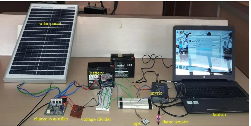
Figure.1 Shows the Block Diagram of Proposed Method. The Block Diagram Consists of two Sections one is Forest Area and another one is monitoring Area. In Forest Area Solar panel, Charge Controller, Battery, MYRIO, GPS, Flame Sensor are connected in transmitter channel. Solar Panel gets Maximum power through Sun using MPPT Algorithm [1][2]. The output of the solar Panel is 20V. The Output voltage is stored using a Battery with the help of charge controller. Charge controller used to maintain the voltage level 12V.
Figure.3. Block Diagram of Proposed Method
IV.HARDWARE IMPLEMNTATION
I. Solar Panel: Table 1. Specifications of Solar panel
Figure 2. Solar panel
Figure.3. lab view model for Solar panel Figure.4. lab view output for Solar panel
II. Charge Controller:
Figure.5. Hardware Circuit for Charge Controller
Figure.6. LabVIEW model for Charge Controller Figure.7. LabVIEW output for Charge Controller
Figure 5. Shows the hardware Circuit for Charge Controller. Charge Controller based on the working of Buck –Boost DC-DC converter. The solar panel output of the 21V is given to Charge Controller. Buck- Boost Convertyes are maintaining the Maximum Voltage level is 12V. Figure 6 & Figure 7 shows the Lab view model and output for Charge Controller.
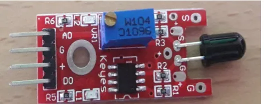
III.Flame Sensor:
Figure.9. LabVIEW model for Flame Sensor
Figure 8 shows the hardware Circuit for flame sensor. It contains analog output, potentiometer, Comparator Chip. Figure 9 & 10, 11 shows theLabVIEW modelling and output for when the fire is detected with flame sensor and when is not detected with flame sensor ( Normal Condition). The performance of the flame sensor can be monitored by using LabVIEW.
V.EXPERIMENTAL RESULTS
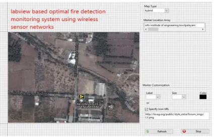
Figure.14. LabVIEW output for Location path finding
Figure 12 Shows that the Experimental Setup For hardware. The solar panel radiates the sun Energy and produces 21V. The 21v DC is given to Charge Controller Circuit. Charge Controller Circuit made up of DC-DC Converter. The voltage is Limited upto 12V and it to be stored in the battery. MyRIO and flame sensors are connected to the battery.
Figure 13 & 14 shows the LabVIEW model and output for GPS. When the Flame sensor are detected the fire with in the range which sends the Latitude location is given to wireless sensor nodes. The Particular location can be obtained by using LabVIEW software.
IV.CONCLUSION
Hardware implementation of forest fire detection using LabVIEW with wireless sensor networks based myRIO and flames sensor performance is validated using LabVIEW. This method is better optimization for comparing the other forest fire detection techniques. In hardware implementation solar panel 21V is given to controller circuit. Charge Controller circuit which provides the constant voltage 12V and stored into battery. Flame sensor and GPS based location monitoring is Connected through myRIO. The output from the flame sensor and gps is received by the myRIO. The labview program with led indication turns ON when fire occur in the forest. The labview monitoring section sends the fire alert message and also sends the location to nearest forest head office which is stored by myRIO port.
REFERENCES
[4] Integrated Management Coastal Research Institute, Polytechnic University of Valencia, Camino Vera s/n, 46022, Valencia, Spain; E-Mails: [email protected] (M.G.); [email protected](D.B.); [email protected] (S.S.) „A Wireless Sensor Network Deployment for Rural and Forest Fire Detection and Verification‟
[5] Seema , Reema Goyal Department of Computer Science & Engineering M. M. Engineering College Maharishi Markendshwar University Mullana, Ambala, Haryana, India International Journal of Advanced Research in Computer Science and Software Engineering „ A Survey on Deployment Methods in Wireless Sensor Networks‟ International Journal of Advanced Research in Computer Science and Software Engineering [6] Montaser N. Ramadan, Mohammad A. Al-Khedher, Senior Member, IACSIT, and Sharaf A. Al-Kheder „Intelligent Anti-Theft and Tracking System for Automobiles‟International Journal of Machine Learning and Computing, Vol. 2, No. 1, February 2012.
[7] N. Han, J. Kan, W. Li and J. Zhang, (2008) “Forest Fire Detection System Based on a Zigbee Wireless Sensor Network”, pp. 369-374. Higher Education Press; co-published with Springer-Verlag GmbH. [2] S.J. Hook and G.C. Hulley, (2011) “Generating Consistent Land Surface Temperature and Emissivity Products Between ASTER and MODIS Data for Earth Science Research”, Geoscience and Remote Sensing, vol. 49, Issue 4, pp.1304-1315
[8] A. Fu, Z. Guo, G. Sun and D. Wang, (2010) “Forest Cover Classification with MODIS images in Northeastern Asia”, IEEE J. Select. Topics Appl. Earth Obs. Remote Sens., vol. 3, no. 2, pp. 178-189.
[9] D. Grimaldi, R. Rak and L. Skrzypczak, (2009) “Basic Characteristics of Zigbee and SimpliciTI Modules to use in measurement systems”, XIX IMEKO World Congress, Fundamental and Applied Metrology, pp. 1456-1460.
[10] Mr.D.velmurugan , P.Elango , R.Kamalakannan , S.Prakash , M.Mohandass, (2017)”A Simulation for Forest Fire Detection Using LabView With Wireless Sensor Networks Based myRio” in International Journal Of Science and Research Development.
[11] Chan-jiang Yao, Xiao-hu Chen, Xu-Ping Wang, Youg-tao Zhou, (2008) “Design of Equipment Remote Monitoring System Based on Embedded Web”, IEEE, pp. 73-78.