PLANNING MALAYSIA
Journal of the Malaysian Institute of Planners (2009) VII, 111 - 132
GROUNDWATER EXTRACTION MODELLING FOR
KUALA LUMPUR WATER RESOURCE PLANNING
Pieter E. Stek 1
UNIVERSITY OF TWENTE, THE NETHERLANDS
Abstract
Potable water consumption in Kuala Lumpur and the su1Tounding area is expected to grow by 34% from 2005 to 2010. This increase in demand will be met by the construction of new reservoirs. However, reservoirs are dependent on rainfall and during prolonged periods of drought, as occurred in 1998, they could become empty. Therefore it is of great importance to develop alternative sources of water supply, including groundwater, to mitigate the effects of a serious water crisis. In this paper, results fron1 a preliminary study on Kuala Lumpur's groundwater resources are presented. Modelling of the city's groundwater resources is extremely difficult given the limitations imposed by data availability and the karstic nature of some aquifers. Hence, the research presented here serves as a sta11ing point for further studies rather than providing any definitive conclusions. In addition to the study results, the planning implications of groundwater extraction are discussed.
Key\vords: Potable water, Kuala Lumpur, Groundwater, Extraction
INTRODUCTION
Kuala Lumpur, with a population of 1.4 million (2000), is the heart of the Kuala Lumpur conurbation (population of 4.2 million in 2000), Malaysia's most prosperous and most densely populated region. Kuala Lumpur is a major commercial and industrial centre in Southeast Asia (Kuala Lumpur City Hall, 2000).
Average per capita income in Kuala Lumpur is approximately double the national average (Kuala Lumpur City Hall, 2000). This means that average purchasing power of city residents (25,600 USD) is comparable to that of developed countries such as Greece (24,000 USD) and New Zealand (26,200 USD). Malaysian average purchasing power per capita (12,800 USD) exceeds
1Forn1er graduate student, University of Twente, The Netherlands
(Email: [email protected])
Piefer E. Srek
Gro1111d\\'ater exrracrio11 modelingfor Kuala Lumpur warer resource pla11ni11g
that of Bulgaria (10,700 USD), a member state of the European Union. (Central Intelligence Agency, 2007)
By 2010 the water supply capacity in the Kuala Lumpur region from reservoirs will be 5.15 million m3/day and the demand will be 5.0 million m3/day, meaning excess capacity is just 3% of the demand (Economic Planning Unit, 2005). This means any disruption in supply can have an immediate and serious effect on supply. To prevent such an occurrence, reservoir capacity needs to be expanded further to create the needed excess capacity or an alternative source of water supply that is independent of rainfall needs to be found. It is herein that groundwater can play a role.
Groundwater is a common source of water supply across the world, which is unsurprising if one considers that it tends to be locally available, often just metres below the point of consumption, it is generally of high quality and it is reliable, being insensitive to short-term rainfall patterns (Custodio, 2002). The fact that groundwater has not been used extensively in Kuala Lumpur can be attributed to the availability of surface water captured by the many reservoirs surrounding the city and the generally poor quality of local groundwater due to local geological conditions (Institute of Environment and Development, 1997). The main obstacle in developing groundwater resources is a lack of knowledge. Conducting the necessary research to gain this knowledge takes up a ve1y large share of the total investment needed to exploit groundwater resources. Uncertainty often makes it difficult for decision-makers to commit to a natural resources or environmental policy (Bressers, 2003).
This paper presents the results from a preliminary study on Kuala Lumpur's groundwater resources. The the01y, methodology and data behind the study are only ve1y briefly described as in-depth knowledge of these details is less relevant from a planner's perspective.
Imp01tant to planners are the unique features of the study area and how these features influence the planning process. Although a lack of groundwater data makes it impossible to make concrete recommendations, there is potential for groundwater extraction in Kuala Lumpur, especially for emergency purposes. However this requires planning to minimise environmental damage to recharge areas and to plan water supply infrastructure close to areas with groundwater potential so that groundwater can be used to make for a shortfall from reservoirs, should the need arise.
Kuala Lumpur has three important characteristics which pertain to groundwater: the area has a rapidly growing economy and population, it has a
PLANNING J\.fALAYSIA
Jo11r11al of the klalaysia11 Institute of Planners (2009)
highly complex geology and there are potentially significant environmental threats to groundwater that cannot be comprehensively assessed at present. These three issues will be addressed below and in that order.
THE GROWING DEMAND
Kuala Lumpur initially developed as a trading centre in the 1850's to service the nearby tin mining industry. Large rnbber and palm oil plantations were established in the vicinity soon after. From the 1950's onwards the city started to industrialise and today all mines and most plantations around Kuala Lumpur have closed. Between 1995 and 2000 average per capita income grew by 6.1 % per year. Population growth is projected at 2.2% per year for the period from 2000 to 2020 (Kuala Lumpur City Hall, 2000).
Kuala Lumpur's water infrastructure is strained and although expansion has generally kept up with fast-growing demand, parts of the system are in very poor shape. Although access to the public water supply is universal, non-revenue water2 stood at 37% in 2005 which is worth more than RM3 1 million per day in lost revenue. Non-revenue water can explain the entire RM 449.1 million annual revenue shortfall of the Selangor water system (Lee, 2005).
Kuala Lumpur was hit by a severe water shortage in 1998 caused by an extended period of drought. Due to its dependence on rain-fed reservoirs for the city's water supply the city may be faced with a similar shortage in the near future (Hamirdin et al., 2004). On a smaller scale, accidents sometimes pollute rivers and reservoirs, temporarily disrupting water supply to pm1s of Kuala Lumpur. Such instances are regularly rep011ed in local newspapers.
Following the 1998 water shortage, a controversial inter-basin water transfer scheme was constructed to supply water from the Selangor river basin, just north of Kuala Lumpur (Tan, 1999). In 2008 construction will start on another inter-basin transfer scheme from Pahang state, southeast of Kuala Lumpur, valued at RM 4 billion. A total of RM 8 billion has been allocated for all water supply projects nation-wide under the Ninth Malaysia Plan (Economic Planning Unit, 2005; Barrock, 2007). Under the Ninth Malaysia Plan, which is the Malaysian federal govenunent's most impo11ant policy document: "
2
The Malaysian Water Association defines non-revenue water as water that is treated but lost due to leakages, theft, pipe bursts and meter under-registration and hence generates no revenue for the water supply con1pany.
3 Malaysia currency is Ringgit or RM.
Piefer E. Stek
Gro1111d11'ater extractio11 modeli11gfor Kuala Lumpur 11·ater resource pla1111i11g
development of groundwater will be promoted as [an] interim measure[s] to address the anticipated shortage of water in Selangor, Kuala Lumpur and Putrajaya." (Economic Planning Unit, 2005). However, no significant groundwater plans have been presented, although groundwater has received some attention in the Malaysian media (Malaysian National News Agency, 2007a; 2007 b ).
To put the water supply and demand numbers into perspective, note that total net rainfall (compensated for evapotranspiration) over the Klang basin alone is on average approximately 5.25 million m3/day which is roughly equal to projected 2010 demand for all of Selangor and the federal ten-itories (Stek, 2008; Rustam et al. 2000). So in theory, there is enough water to meet Kuala Lumpur's needs, the question is can it be captured?
THE STUDY AREA
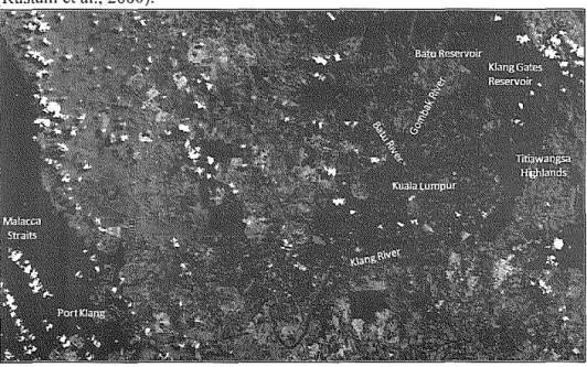
Kuala Lumpur is located in the eastern part of the Klang River basin (total area of 1,2 78 km'). The Klang, Gombak and Ba tu rivers originate in the densely forested foothills of the Titiawangsa mountain range, north of Kuala Lumpur and have their confluence near the old city centre (see Figure !). The Klang River then continues its journey through the relatively flat and heavily urbanised valley floor before discharging into the Melaka Straits at Port Klang (Rustam et al., 2000).
Figure 1: Colour composite satellite image (Landsat) of the Klang basin.
PLANNING 111Altl YSIA Jo11r11al of the i'vlalaysian lnslilllle of Plmmers (2009)
The Klang basin has a tropical climate with abundant rainfall of 2700 mm per annum. The maximum precipitation occurs in October and November and in April, coinciding with the sontheast and southwest monsoon seasons respectively (Rustam et al., 2000). Rainfall is also the primary source of the basin's two main drinking water reservoirs (Klang Gates reservoir and Ba tu reservoir).
On a smaller scale, tin ponds are one of the most important hydrogeological features of Kuala Lumpur. Limestone, being easily erodible, traps mineral deposits (especially tin) in its extensive networks of fractures, conduits and cavities. Tin deposits were mined from the l 850's until the l 980's in open-cast mines. These mines have since been closed and flooded, creating Kuala Lumpur's characteristic tin ponds (Yin, 1986). Because of the high permeability of the limestone formations, the tin ponds play an important role in regulating Kuala Lumpur's water balance, providing water storage during heavy rains and being a major source of groundwater recharge. The groundwater table in the valley is quite shallow at around 5 metre below the surface, making it sensitive to pollution (Binnie dan Rakan, 1980).
The irregular limestone formations also pose geotechnical engineering challenges. If groundwater levels fall and cavities and tunnels are drained, this can lead to sudden catastrophic land subsidence (sinkhole formation) as illustrated in Figure 2. The sudden loss of suppmt provided by the groundwater has caused the collapse of buildings in the past. Often these occurrences were related to the draining of tin mines or major construction projects (Tan, 2006).
Initial situation Groundwater table lowered
Sinkhole formation
Figure 2: Simplified illustration of sinkhole formation mechanism.
Other geotechnical challenges are posed by the steep hills that surround most of Kuala Lumpur. Some of these hills have been cleared from natural vegetation to make way for development. Here, heavy rains occasionally induce landslides, some of them involving loss of life (Institute of Environment and
Pieter E. Srek
Groundwater extraction modelillgfor Kuala Lumpur water resource pla1111ing
Development, 1997). These landslides are usually caused by inadequate local drainage which causes the soil to become saturated and lose its carrying capacity. However, it is a very local problem; whereas sinkholes can be induced by groundwater extractions hundreds of metres away (Tan, 2006; Craig, 1997).
ENVIRONMENTAL RISK
In addition to the risks posed by an unstable subsurface, there is a significant risk of severe pollution from other sources, including poorly constructed landfills. Leachate4 is a known problem near landfills, and given that the groundwater table is shallow at approximately 5 metre deep, the entire water system is susceptible to pollution. Leaching in tropical climates is often more severe than in temperate climates because heavy rainfall generates more effluent from landfills.
The protection of groundwater recharge zones, one way of eliminating environmental risks, is the responsibility of the Department of Town and Country Planning and the local authorities. It delineates and classifies Environmentally Sensitive Areas into 3 ranks. Rank 1 is the most stringent and absolutely no development is allowed there. Rank 2 allows development only under special circumstances. Rank 3 permits for development, but insists that it be monitored carefully by local authorities. The upper part of the Klang basin is Rank 1 because it is a part of Peninsular Malaysia's central forest spine and a catchment area for the Klang Gates and Batu reservoirs (Federal Department of Town and Country Planning Peninsular Malaysia, 2005).
The valley floor on which most of Kuala Lumpur is built is classified as Rank 3 and hence it still poses a significant environmental risk. This is due to the limestone subsurface which is prone to sinkhole formation and the threat from pollution, erosion and flooding. Kuala Lumpur City Hall recognises its responsibility in monitoring development, but also states in its Strategic Plan that there is no policy at the moment to deal with these environmental issues (Kuala Lumpur City Hall, 2000; Federal Department of Town and Count1y Planning Peninsular Malaysia, 2005).
Another component in environmental risk reduction is adequate environmental protection legislation. Under the Environmental Quality Act (1974), only 'large scale' developments need to submit an Environmental
4
Leachate is the product of water percolating through polluted soil or a landfill that reaches and pollutes the groundwater system.
PLANNING JIALAJ'SJA .!our11al of the Alalaysia11111slit11te of Planners (2009)
Impact Assessment to the Depmtment of Environment. 'Small scale' developments, including shopping centres, office towers and apartment buildings, do not require an Environmental Impact Assessment but only a building permit issued by the local authority. In some cases projects are deliberately split into smaller pieces to circumvent the Environmental Quality Act (Perunding Zaaba, 1999; Neergaard, 2003).
Although new landfills do require an Environmental Impact Assessment, the enforcement of the legislation on this issue can also be circumvented. Datuk Shahrir Abdul Samad, a senior National Front member of parliament, noted that for the Kundang landfill, operated by the Selayang Municipal Council, no preliminary Environmental Impact Assessment repo1t was submitted. Because there is no Environmental Impact Assessment, the Department of Environment has no ground for enforcement (Mutadir, 2006). It must be noted that such behaviour by municipalities is not the norm. For example, Kuala Lumpur City Hall recently invested RM 24 million to properly decommission the Taman Beringin landfill (Lim, 2008).
To evaluate the results of these policies, groundwater monitoring data provided by the Department of Environment provides some indicators. Near landfills groundwater is polluted, especially by Manganese. Manganese is a heavy metal commonly found in batteries and other industrial chemicals. Manganese leaching is a known problem and has been reported at least since the late 1970's (Binnie dan Rakan, 1980). Monitoring also takes place at other sites, such as golf courses. Here, groundwater quality seems to be fair (Department of Enviornment, 2007). Casual observation of tin pond in Kuala Lumpur suggests that their water quality is also fair, as they are popular fishing spots with local residents.
Nevertheless, one must conclude that large-scale groundwater pumping may cause unexpected groundwater flows, especially near polluted sites, which can have disastrous consequences for a groundwater pumping project and the general environment. Responsible groundwater development cannot proceed without adequate knowledge of these threats.
GROUNDWATER MODEL
Due to the fact that this article is aimed at town planners rather than engineers or hydrogeologists, this section only addresses some aspects of the groundwater modelling process. The modelling aspects that are addressed in this section are: the reasons for modelling, the assumptions on which the model is based, the
Piefer E. Stek
Growulwater e.xtrac/ion modelingfor Kuala Lumpur \\'a/er resource pla1111i11g
simulation results and the limitations of the model. For a more comprehensive description of the modelling process, a discussion of the relevant theory and more detailed descriptions of the input data and the results, please refer to Stek, 2008.
WHY MODEL?
The quantification of groundwater resources often proves to be a fo1midable challenge. It is difficult to quantify groundwater resources because required data acquisition can be prohibitively expensive. Just like the exploitation of oil and gas reserves, exploration costs account for a large part of the investment needed to safely exploit groundwater resources. Hence it is important to quantify groundwater resources accurately and cheaply early on in the development process so that the necessary information is available for timely
decision-making.
There are several different methods of groundwater quantification, one of them is modelling. Groundwater models can be used to study the sensitivity and dynamics of the groundwater system and to organize available field data (Anderson and Woessner, 1992). This gives modelling a significant advantage when analysing Kuala Lumpur's very inhomogeneous hydrogeology over other quantification methods such as pumping tests and groundwater potential ma pp mg.
Pumping tests5 are primarily influenced by local hydrogeological conditions and therefore, if the hydrogeology is highly variable, the results are not valid for a wider area and therefore of limited value in larger-scale groundwater studies (Lubczynski and Gurwin, 2005). Groundwater potential mapping6 is a very powerful tool for estimating groundwater recharge in large vegetated areas. However in urban areas recharge is heavily influenced by factors such as leaking pipes and complex land use for which groundwater potential mapping methods are ill-suited (Lerner, 2002).
5
Pun1ping Test: a 1nethod for determining the transmissivity (hydraulic conductivity x aquifer thickness) and storativity (volume of water released from storage per unit decline in the hydraulic head) of an aquifer and to establish the reliable yield of a well and to find out if the well affects other wells and springs.
6
Groundwater Potential Mapping: a method for estimating groundwater recharge using climate (e.g. rainfall, evaporation), geophysical (e.g. slope, soil type) and land-use data (e.g. vegetation type). Recharge is then used to estimate the potential an1ount of groundwater that can be extracted.
PLANNING k/ALAYSIA Journal of the kfalaysian lnstitute of Plan11ers (2009)
Gaining knowledge about the dynamics of the groundwater system, i.e. how it will react to certain changes, is of great importance to assess potential environmental risks. This assessment must occur at different scales: from the perspective of the water balance of the entire hydrological system and from the local impact of pollution. From the planning perspective it is now most important to uncover the larger, hydrological system perspective because data for modelling on smaller scales is unavailable.
The question that the model needs to answer is: What are the physical effects of groundwater extraction? The answer that town planners and decision makers specifically seek is: How much water can safely be extracted? If this quantity is fairly large and the environmental impact seems mild, then there is a strong case to be made to develop groundwater resources in Kuala Lumpur and to enforce more stringent planning rules to protect groundwater recharge zones. The quality of the answer the model provides depends on the validity of the assumptions on which it rests.
MODEL ASSUMPTIONS
There are three areas in which assumptions must be made: (I) the data used in the model, (2) the theory underlying the model and (3) the criteria defining what constitutes environmental damage. These matters, in addition to some details about the available data and model, are discussed in this section.
First off, the groundwater model uses the Modular Finite-Difference Groundwater Flow (MODFLOW) code to simulate groundwater flows. MODFLOW is a finite difference code based on the ground flow water equation which is based on uniform laminar groundwater flow (Anderson and Woessner, 1992). In the case of Kuala Lumpur's hydrogeology, both of these assumptions are violated. The fractured limestone aquifers are not uniform and non-laminar flow occurs through the fractures.
The MODFLOW model is instead based on the assumption that on a large scale, say with model cells of 300 m by 300 m, the groundwater system behaves as if it were a porous medium with uniform laminar groundwater flows. This allows the hydraulic conductivity, the most important parameter in the groundwater flow equation, to be calculated. However, this hydraulic conductivity is artificial and describes flow through a completely theoretical 'equivalent porous medium'. The success of this approach lies not in its theoretical beauty but in the fact that it has been applied successfully to model
Pierer E. Stek
Grou11d11y1/er extraclio11111odeli11gfor Kuala Lumpur \\'a/er resource pla1111i11g
groundwater flows in many other studies, across the world (Anderson and Woessner, 1992; Scanlon et al., 2003; Lubczynski and Gurwin, 2005).
The second model assumption is that the groundwater system in Kuala Lumpur is steady-state; that inflows equal outflows and that both are constant. This statement is based on the casual observation that tin ponds have near-constant water levels throughout the year and the assumption that these ponds play a dominant role in regulating the water table, which must therefore also be near-constant. This assumption also allows data to be used from different periods in time as water levels are assumed to be constant. Since there is no continuous monitoring of groundwater levels in Knala Lumpur, this assumption cannot be confirmed.
In order to construct a reliable model, the data used must be representative for the entire study area: it simply is not. Although there are 1305 measurement points for a model area of 42 by 31 km, there is a deficit in measurement points from the mountainous areas surrounding the valley floor. This causes several problems for interpolation and modelling (Stek, 2008). If certain assumptions (or rather, 'educated guesses') are made about the water table in these mountainous areas, a reasonable model can still be calibrated; nevertheless these assumptions should be confirmed through additional tneasurements.
To calculate the inflows and outflows of water in the groundwater model, a water balance is constructed that relies on satellite observations to measure evaporation and assumptions about pipe leakage. Both of these methods can be called into question, but they nevertheless give the best available estimate of the current situation. Because large parts of the local hydrogeology remain unexplored, the depth of the model (limited to 300 metre) and the exact location and nature of the hydrological boundaries are still uncertain.
Third, because Kuala Lumpur had tin mining until the 1980's, which lowered local groundwater tables far in excess of 5 metre in the most sensitive limestone areas, it is assumed that a fall of 5 metre or less in the local water table does not pose an environmental threat (Yin, 1986). This assumption is posited here without providing any strong, empirical evidence.
All these assumptions leave the model open to a multiplicity of outcomes: if the assumptions are changed, the outcomes will be different. Even the outcomes generated from the same assumptions may not be the same. Nevertheless, if the assumptions and outcomes are deemed to be reasonable, simulations results should be accepted in the absence of better data. Naturally,
PLANNING JIALAYSIA
Journal of the i\Jalaysian Institute of Planners (1009)
the above assumptions should be verified to confirm the validity of the model results.
SIMULATION RESULTS AND MODEL LIMITATIONS
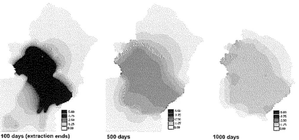
The model is used to simulate two extreme extraction alternatives: a permanent extraction of 8,000 m3/day at 12 locations in Kuala Lumpur and a temporary extraction of 80,000 m3/day at 12 locations that lasts 3 months after which there is a 3-year recovery period. The purpose of these simulations is to test the limitations of two approaches to using groundwater in Kuala Lumpur's water supply. The first simulation considers groundwater as a permanent additional source (yielding 96,000 m3/day, 1.9% of2010 projected demand), the second as a source to make up for a temporary shortfall in reservoir storage (yielding 960,000 m3/day, 19% of2010 projected demand).
Both alternatives, when simulated in the model, cause a maximum drawdown of 5 m. To get a better appreciation of the model output, please refer to Figure 3. The model is able to simulate where most drawdown is likely to occur (caused by the pumping locations in the limestone aquifer) and how groundwater flows as the water table recovers following the end of groundwater extraction. If the model assumptions can be confirmed using additional measurements, then the model clearly offers valuable simulation results.
100 days (extraction ends) 500 days 1000 days
Figure 3: Sample model output for 3 month drawdown followed by 3 year recovery.
Piefer£. Stek
Groundwater ex1ractio11111oddi11gfor Kuala Lumpur 1\'aler resource planning
It must be noted that the model only provides a rough simulation of the study area: it cannot be used to predict the local effect of groundwater extractions because these are influenced by factors that act on a much smaller scale and therefore cannot be taken into account by the present, large-scale model.
Groundwater modelling, monitoring and extraction are a process of continuous improvement not dissimilar to the Japanese kaizen philosophy of industrial process improvement that has been fmmalised in the ISO 9001 :2000 standard. Hence, as more data becomes available, which is generated as pumping gets underway, groundwater modelling efforts and simulation results should be further improved (Von Storch, 2004).
DISCUSSION OF PLANNING IMPLICATONS
The primary argument in favour of groundwater extraction is financial. Adding additional water supply capacity to the Kuala Lumpur water system by developing groundwater resources is cheaper than the main alternative: expanding reservoir capacity. It is this comparison that the first part of this section focuses on, followed by a brief consideration of the current institutional barriers to the implementation of comprehensive groundwater planning. In the last part of this section, physical planning implications are touched upon again, and several points that have already been made in previous sections are briefly revisited.
Financial
To meet Kuala Lumpur's growing demand for water, large investments are being made. The Malaysian government has earmarked RM 8 billion for investment in water supply infrastructure for the period of 2006-20 I 0. Of this, RM 4 billion will be invested in the Pahang Selangor Water Transfer Scheme which, when completed, will provide the Kuala Lumpur Conurbation with 2.2 million m3/day (Economic Planning Unit, 2005; Ministry of Energy, Water and Communications, 2007).
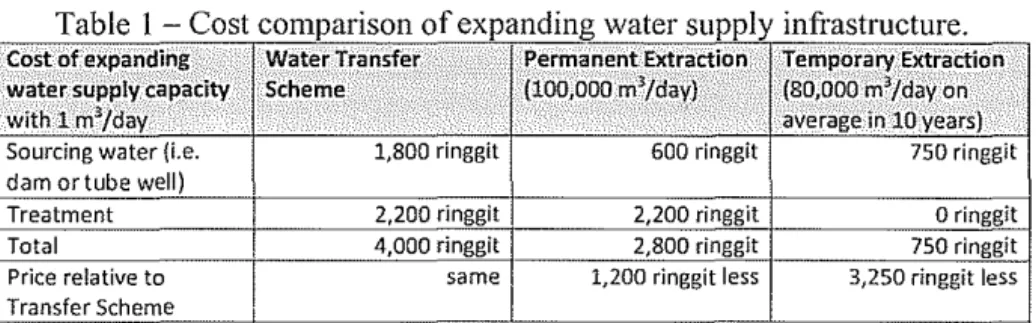
In this analysis, the Water Transfer Scheme serves as an indicator of the Malaysian government's "willingness to pay" for new water supply infrastructure. The cost of the Water Transfer Scheme is compared to a permanent groundwater extraction project and a temporary groundwater extraction project in Table I. Although this is an imperfect analysis, as costs are based on rough estimates and the price of the Water Transfer Scheme may be
PLANNING 1\IALA YS/A
.!011r11af of the Afalaysitm bisti/11/e of Planners (2009)
somewhat inflated because it is financed by soft loans provided by the government of Japan (Bmrnck, 2007), the cost comparison does provide a starting point to consider the financial implications of groundwater extraction projects in Kuala Lumpur.
Table 1 - Cost comparison of expanding water supply infrastructure Cost ofexpand_ing Water Tr~nsfer Pennanent Extraction Tempora_ry Extraction water, supply capacity Scheme (100,000 m3/day) (80,000 m3/d?.y on
with 1 m3/day
.
·. average in 10 years)Sourcing water (i.e. 1,800 ringgit 600 ringgit 750 ringglt dam or tube well)
Treatment 2,200 ringgit 2,200 ringgit o ringgit
Total 4,000 ringgit 2,800 ringgit 750 ringgit
Price relative to same 1,200 ringgit less 3,250 ringgit less Transfer Scheme
All costs are calculated as a price per m1 of daily water supply capacity. The costs of the Water Transfer Scheme consist of two parts, the construction of a large reservoir (55%) and the construction of water treatment facilities (45%) (Ministry of Energy, Water and Communications, 2007; The Edge, 2007). The cost of the groundwater projects include the construction of tube wells, monitoring wells, some piping and land acquisition at 12 extraction sites and is estimated at a total sum of RM 60 million. In addition to this, there is a cost for constructing treatment capacity, estimated at RM 2,200 per m1 for all scenarios (Stek, 2008). Note that for the Temporary Extraction scenario there are no treatment costs because in this scenario, unused treatment capacity created by a water shortage is utilised, hence the RM 0.00 investment. Also note that the cost per m1 of extracted water for the Temporary Extraction scenario is higher (RM 750/m1) because extraction (800,000 m3/day during that period) only takes
place for three months every 10 years (hence 80,000 m3/day on average), increasing the cost per m3 of capacity because the required investment (RM 60 million) does not change.
Essentially this cost analysis suggests that groundwater projects are between RM 120 to 260 million cheaper than obtaining the equivalent water supply capacity from reservoirs. Nevettheless, there are some caveats. First, the Temporary Extraction scheme does not provide regular water supply capacity; it provides extra capacity during water emergencies. This means that decision makers will look at this option differently; they may instead choose to impose water rationing which brings with it minimal investment costs but could cause significant economic disruptions and popular discontent.
Pieter E. Stek
Gro1111d1rn1er e.r11·ac1io11111odeli11gfor Kuala Lumpur water resource pla1111i11g
Second, the groundwater extraction schemes carry significant environmental risk. A groundwater extraction program may have to be closed down and the investment written off if environmental problems occur.
These are two kinds of environmental risk: the risk from groundwater extraction itself (mainly the lowering of the water table and induced flows) and the fact that groundwater recharge areas may be inadequately protected due to inadequate or poorly enforced land use planning rules. Kuala Lumpur is largely classified as an Environmentally Sensitive Area, yet local authorities lack the capacity to plan appropriately for this fact.
bzstit11tio11a/
To gain insight into why there has been very little policy or planning with regards to groundwater extraction in Kuala Lumpur, we view the decision-making process from the perspective of Bressers, who stresses the importance of policy coherence between different actors (Bressers et al, 2003). Bressers' theories were developed by studying decision making in European Union water management projects and there are many parallels between this situation and the complex interaction between actors of Malaysia's local, state and federal
governn1ents.
Bressers maintains that policy coherence between all relevant policy actors is absolutely necessary to manage water in a sustainable way. This is because it entails policy actors adapting to each other, stabilising the water
n1anage1nent regime and ensuring the con1mitment and cooperation necessary to
carry out sustainable water policies. Policy coherence cannot simply be imposed, because there is no policy actor that has full control and is able to do it. Even a powerful government agency will need to respect property rights, legal jurisdictions and prevailing interests (Bressers, et al, 2003).
Bressers also observes that there are several key barriers to making groundwater policy that prevent a win-win situation or profitable trade-offs between policy actors. Uncertainty, along with the problem's complexity, the long-term time-scale of groundwater changes and pluralism (i.e. the presence of multiple policy actors) can prevent effective decision making (Bressers, et al., 2003).
Regulation of groundwater in Kuala Lumpur is highly fragmented as more than 13 government actors dealing with groundwater can be identified (see Table 2). These institutions are discussed below, starting with the
PLANNING 1l!ALAYS/A Jo11r11al of the Aluloysit111 J11stil11te of Plwmers (2009)
distribution of state and federal responsibilities, a description of state agencies, federal agencies and then the role of local authorities and private parties.
Table 2: Overview of organisations dealing with groundwater in Kuala Lumpur Conurbation
. Ministry of Natural Resources and Environment
•
Department of Environment• Department of Minerals and Geoscience
• National Hydraulic Research Institute Malaysia Ministry of Federal Territories
Federal Agencies
•
Kuala Lumpur City HallMinistry of Energyt Water and Communications
•
National Water Services Commission Treasury (Ministry of Finance)•
Water Asset Holding Company Ministry of HealthMinistry of Natural Resources and Environment
•
Department of Irrigation and Drainage Federal and State Ministr}:'. of Housing and local GovernmentAgencies • Town and Country Planning Department Ministry of Public Works
•
Department of Public Works Selangor Waters Management AuthoritySelangor State Agencies Kumpulan Darul Ehsan Berhad (Selangor State Investment Company) local Authorities of Selangor State such as Ampang Jaya Municipal Council, Petaling Jaya City Council, etc.
Private Companies Selangor Water Supply Corporation
Malaysia is a federation in which state governments have significant autonomy. Under article 73 of the federal constitution, state governments have jurisdiction over water and land resources, whereas the federal government can legislate on interstate issues such as pollution control, mining and public health (Perunding Zaaba, 1999). However during the past decades financial resources and decision making have increasingly moved towards the Federal Government, making states more dependent on it to fulfil their constitutional obligations (Jomo and Wee, 2003).
Selangor state has created a single agency, the Selangor Waters Management Authority, to manage its key responsibilities in the fields of water resources and water supply. In Selangor and Kuala Lumpur the water supply system is operated by the Selangor Water Supply Corporation, a private company which has a concession granted by the Selangor state government and which is part-owned by the Selangor State Investment Company - Kumpulan Darul Ehsan Berhad (KDEB).
Pie/er E. Stek
Groumhraler extraction modeli11gfi1r Kuala Lumpur irater resource pla1111i11g
The Selangor Waters Management Authority relies on expertise from the federal government's Department of Minerals and Geoscience and the Department of Environment to carry out its duties. At the state level, the Selangor Waters Management Authority interacts with the Department of IITigation and Drainage and the Public Works Department. These two agencies are involved in the design and construction of physical infrastructure. The Town and Country Planning Department is responsible for land use planning at the national and state levels, which includes gazetting sensitive riparian areas and groundwater recharge zones.
The Selangor Water Supply Corporation, being a private water utility, is regulated by the federal government's National Water Services Commission. The Commission regulates water prices, piped water quality and water delivery. The Selangor Water Supply Corporation buys water from water treatment plants which are operated by other companies. Some of these plants are privately owned, others are owned by the state government or the federal government's Water Asset Holding Company. Because the Selangor Water Supply Corporation supplies drinking water, it is also supervised by the Ministry of Health which operates small-scale water supply projects in some rural areas, but not in Kuala Lumpur.
The Depaitment of Irrigation and Drainage, the Department of Public Works and the Department of Town and Count1y Planning are federal departments but the state governments hold significant powers over their state level operations. The Department of Environment and the Department of Minerals and Geoscience are pure federal agencies who assist state governments but are not controlled by them.
Local authorities such as Kuala Lumpur City Hall are required to monitor development in Environmentally Sensitive Areas and withhold building permits if it is deemed prudent to do so (Institute of Environment and Development, 1997). Local authorities fall under the control of the state government (there are no local elections), and in the case of Kuala Lumpur, which is a federal territo1y, under the Ministry of Federal TeITitories.
It is important to note that the Selangor Waters Management Authority faces several 'holes' in its jurisdiction, notably Kuala Lumpur. In Kuala Lumpur, the Selangor state government is required to supply water (a duty carried out by the Selangor Waters Supply Corporation) but it has no
jurisdiction over the city's water resources. Research on water 1nanagen1ent
issues is conducted by the National Hydraulic Research Institute Malaysia, an institute of the Minist1y of Natural Resources and Environment.
PLANNING 1UALAYSIA
.!011r11al of the Alalaysfrm /11.1·1it111e of Planners (2009)
To fully appreciate the problems this fragmentation brings, it is important to note that the Malaysian government is very legalistic and hierarchical. This can prevent cooperation between different levels of government. This legalistic nature of the government is evident from the following example about groundwater monitoring activities. The Department of Environment monitors groundwater quality as part of its tasks to control pollution under the Environmental Quality Act (197 4 ). The Department of Minerals and Geoscience monitors groundwater levels because it has to study hydrogeology as instructed by the Geological Survey Act (1974). This leads to the peculiar situation where both departments operate completely separate groundwater monitoring networks. At Department of Environment wells only groundwater quality is measured. At Department of Minerals and Geoscience wells only groundwater levels are measured. However both departments fall under the same Ministry of Natural Resources and Environment.
In terms of hierarchy, federal ministers and state chief ministers have roughly the same level of authority. So for a comprehensive groundwater policy to be initiated in Kuala Lumpur, the chief minister of Selangor and eight federal ministers must reach agreement. This fragmentation of authority makes regulation of water resources in Malaysia ineffective (Zakaria, 200 I; Madsen, et al., 2003; Mutadir, 2006).
Only the Prime Minister, backed by the federal parliament and the treasury, has a higher standing than the federal ministers and the chief ministers. The Economic Planning Unit of the Prime Minister's department establishes 5-year plans which direct policy for all ministries and state governments. The current 5-year plan (2006-2010) is the Ninth Malaysia Plan.
The hierarchical structure of Malaysia's government is very suitable for pushing through large projects such as the Pahang Selangor Water Transfer Scheme, the Kuala Lumpur International Airport or the Kuala Lumpur Light Rail Transit but it makes coordination of small-scale projects much more difficult as many issues, including jurisdiction and funding, need to be resolved. To solve this problem, the federal Treasury could instead allocate grants for groundwater development, but leave government agencies or consortia of government and private agencies to come up with a plan, forcing them to work together. The advantage of the grant system is that it leaves the current institutional landscape intact while giving the federal government the ability to direct water policy, without micro-managing it. This is an advantage, considering that the Economic Planning Unit or the Treasury cannot and should not know enough about water management.
Pie/er E. Stek
Groundwater e.xtrllction 111odeli11gfi1r Kuala Lumpur 1n1/er resource pla1111i11g
By forcing agencies to work together, enforcement and monitoring activities can be rationalised and expertise combined. The federal Treasury could then appoint a committee of experts to select the best plan. Such procedures are also used by the European Union to disburse nearly 347 billion euro in grants via the European Structural Fund and the European Cohesion Fund to finance infrastructure and socio-economic developments in its 27 member states (European Commission, 2006).
Physical
Although a comprehensive description of how groundwater development in Kuala Lumpur should be planned is far beyond the scope of this paper, but there are several criteria that can be fonnulated based on which groundwater related land-use planning should take place. Tin ponds have an important role to play in regulating the groundwater table, especially in the fractured limestone aquifers. City Hall is also constructing many flood retention ponds that could double as infiltration ponds. However, in all cases, land use planning must ensure that polluted runoff does not reach the ponds to protect the groundwater system (Kuala Lumpur City Hall, 2000).
Groundwater recharge areas have already been delineated by the Depmiment of Town and Counl!y Planning as protected areas, however appropriate environmental management by local authorities remains a problem that must be addressed through better planning at the municipal level. Infrastructure that may influence groundwater quantity and quality, such as large-scale urbanisation, the construction of reservoirs and land-fills and the location of potentially hazardous industrial facilities, must take into account the possible use of groundwater in the future as the rehabilitating groundwater systems is a long-term and potentially ve1y expensive process.
At a more macro land use planning level, having access to a safe and reliable supply of groundwater may make certain areas more attractive to residents and certain industries. A high technology manufacturer that uses large quantities of water or a five star hotel must have access to a reliable water supply to operate. I-Jenee zones where high-value activity takes place should be planned in areas where the water supply can be guaranteed, either by dive1iing water from other areas or providing locally available groundwater.
At the micro-level, land-use planners should also consider possible locations of pump sites in the design and planning of new water supply infrastructure. Optimum locations for tube wells are (I) close to water treatment facilities, (2) close to recharge areas to minimise potentially adverse
PLANNING i1JALAYSIA
Jo11r11al of the AJalaysfrm !11slit11te of Planners (2009)
groundwater flows, (3) far away from environmental risks and (4) easily accessible for monitoring and maintenance.
CONCLUSIONS
The motivation for exploring groundwater as a potential source of potable water is clear: groundwater stored underneath Kuala Lumpur is independent of short-term rainfall patterns and it can thus make up for a shortfall from rainfall-dependent reservoirs when Kuala Lumpur faces another water crisis.
Some planning criteria have been outlined above; however the main obstacle facing engineers, environmental scientists and town planners alike is a lack of data. It is impossible to make good planning decisions without adequate information. Therefore, the iterative process of groundwater planning: research, decision making and then providing funding for additional research, is exceptionally important. It requires cooperation between different parts of the government which is very difficult under current circumstances.
In a world of dwindling water supply and growing water demand, careful water and land use planning may ensure that Kuala Lumpur is able to meet demand even during periods of reduced supply. This is as much a social issue as an economic one, as scarcity will increase the value of the city's water resources.
But this value can only be tapped through comprehensive and long-term planning which protects groundwater recharge areas while exploiting the available groundwater resources sustainably and efficiently, adding to the city's competitive advantage and prosperity.
ACKNOWLEDGMENTS
The author would like to thank officers from the Department of Environment, the Department of Minerals and Geoscience, the Selangor Waters Management Authority and the International Islamic University Malaysia for the invaluable assistance that they provided for this study.
Piefer E. Stek
Growuhrater extruclio11111odeli11gji)r Kuala Lumpur 1n11er resource pla1111i11g
REFERENCES:
Books/Joumals:
Watts, R.L., 1966. New Federations: Experiments in the Commonwealth.
Oxford: Clarendon Press.
Anderson, M.P. and W.W. Woessner., 1992. Applied groundwater modeling:
simulation of flow and advective transport. San Diego, California: Academic Press.
Ban-ock, J., 2007. "Gamuda out of RM 4 Bil. water deal", The Edge. December 3.
Binnie dan Rakan., 1980. Investigations for Suitable Sources of Water Supply for the Klang Valley. Shah Alam: Selangor Water Supply Department. Bressers, Hans, Doris Fuchs and Stefan Kuks., 2003. "Integrated governance
and water basin management. Conditions for regime change towards sustainability" in Institutional Resource Regimes and Sustainability, Ed. Hans Bressers and Stefan Kuks. Dordrecht, Netherlands: Kluwer Academic Press.
Central Intelligence Agency., 2007. The World Factbook. Washington, D.C.: Central Intelligence Agency.
Craig, D.F., 1997. Soil Mecha11ics, 6'" Edition. London: Spon Press.
Custodio, Emilio., 2002. "Aquifer overexploitation: what does it mean9 " HydrogeologyJourna/, 10, pp. 254-277.
Department of Environment., 2007. E11vironmental Quality Report 2006.
Putrajaya: Department of Environment.
Federal Department of Town and Country Planning Peninsular Malaysia, 2005.
National Physical Plan. Kuala Lumpur: Federal Department of Town and Country Planning Peninsular Malaysia.
Economic Planning Unit., 2005. Ninth Malaysia Pla11. Putrajaya: Prime
Minister's Department.
Hamirdin !thin, Jamalia Jenni and Nik Nasriah Che Abd. Rahman., 2004.
Prospects of A Recurrence of Water Crisis i11 the Klang Valley, Malaysia.
Kuala Lumpur: University of Malaya.
Institute of Environment and Development, National University of Malaysia., 1997. Urbanisation and Environment in lvfalaysia. Chiba, Japan: Institute of Developing Economics.
Joma, K.S. and C.H. Wee., 2003. "The Political Economy of Malaysian Federalism: Economic Development, Public Policy and Conflict Containment", Journal of International Development, 15, 441-456.
Kuala Lumpur City Hall., 2000. Kuala Lumpur Structure Plan. Kuala Lumpur:
Kuala Lumpur City Hall.
Lee, Cassey. 2005., Water Tari.f]S and Development: The Case of Malaysia.
Kuala Lumpur: University of Malaya.
PLANNING iUALA YSJA
Journal of the Aialaysfr111 J11slit111e of Planners (2009)
Lerner, D.N. 2002., "Identifying and quantifying urban recharge: a review",
Hydrogeology Journal, I 0, pp. 142-152.
Lim, Jessica. 2008., "Greening garbage hill", New Straits Times, February 11. Lubczynski, Maciek and Jacek Gurwin., 2005. "Integration of various data
sources for transient groundwater modeling with spatio-temporally veriable fluxes - Sardon study case, Spain", Journal of Hydrology, 306, pp. 71-96.
Madsen, Line et al., 2003. Implementation of a Water Vision - In the case of
Langat River, Malaysia. Roskilde, Denmark: Roskilde University, 2003.
Mutadir, Heikal Abdul., 2006. "EIA, a toothless tiger?" Malaysian Business, June 16.
Neergaard, Andreas., 2003. Environmental Impact Assessment - Procedure and
Requirements in Malaysia. Copenhagen, Denmark: University of
Copenhagen.
Perunding Zaaba., 1999. Ins!Uutional and Legal Study/or The Establishment of
a State Government River Management Institution. Shah Alam: Selangor
State Government.
Rustam, R. et al., 2000. Impact of Urbanization on Flood Frequency in Klang
River Basin. Bangi: National University of Malaysia.
Scanlon, Bridget R. et al., 2003. "Can we simulate regional groundwater flow in a karst system using equivalent porous media models? Case study, Barton Springs Edwards aquifer, USA" Journal of Hydrology, 276, pp. 137-158. Tan, B.K., 2006. Urban geology of Kuala Lumpur and Ipoh, Malaysia. Bangi:
National University of Malaysia
Tan, C.S., 1999. "Project woes", The Edge, July 23.
The Edge., 2007. "Pahang-Selangor water transfer to cost RM 3.9b'', The Edge, November2.
Von Storch, K., 2004. "Reliable groundwater management: the continuous improvement method", Environmental Geology, 46, pp. 617-621.
Yin Yee Heng., 1986. The Geology and Mineral Resources of the Kuala
Lumpur - Klang Area. Kuala Lumpur: Minerals and Geoscience
Department.
Zakaria, S., 2001. "Langat River Basin: A potential for further abuse?"
Proceedings of the 200 I Lang at Basin research symposium. Bangi:
Institute for Environment and Development, National University of Malaysia.
I11ter11et:
European Commission., 2006. European Commission Regional Policy
-Inforegfo, June 6. May 23, 2008.
(http:/ /ec.europa.eu/regional__policy/funds/prord/sf _ en.htm). Last visited on 23 May 2008.
Pieter E. Stek
Gro111ulwa1er extractio1111wdelillgfor Kuala Lumpur 11·ater resource pla1111i11g
Malaysian National News Agency., 2007a. "Harvesting Rain And Ground Water To Deal With Water Woes", BERNAMA.com, April 12.
Malaysian National News Agency., 2007b. "Underground Water, A New Source For Water Supply", BERNAMA.com, March 22.
Ministry of Energy, Water and Communications., 2007. Minislly of Energy,
Water and Communications Official Website.
(http://www.ktak.gov.my/templateO l.asp?contentid=289). Last visited on 11 February 2008.
Stek, Pieter., 2008. Urban Groundwater Extraction in Kuala Lumpur, Malaysia. Unpublished M.Sc. Thesis. Enschede, Netherlands: University ofTwente. (http://essay.utwente.nl/58112/l/scriptie _P _ Stek.pdf)