United States Department of the Interior
BUREAU OF LAND MANAGEMENTAnchorage Field Office 4700 BLM Road
Anchorage, Alaska 99507-2591 http://www.blm.gov/ak
Joint Base Elmendorf – Richardson Communication Site Authorizations
Environmental Assessment, DOI-BLM-AK-A010-2012-0013-EA Case Files: AA-092901, AA-093057, AA-093089, AA-093090
DECISION RECORD Background
Joint Base Elmendorf-Richardson (JBER) is a joint U.S. Army and U.S. Air Force military base located on the northwest edge of Anchorage, Alaska. JBER is a former parcel of Federal land which was withdrawn from the public domain for administrative use by the Department of Defense by Executive Order (EO) 8102 on April 29, 1939.
At JBER, the Bureau of Land Management (BLM) manages all surface natural resources for non-military uses. On JBER, the BLM has responsibility for reviewing and authorizing all activities proposed for non-military purposes with concurrence from the military.
The BLM has received four independent communication site application requests at JBER. In summary, three of the four pending applications are for new facilities in developed areas of JBER. Each of the three would include new free-standing ground equipment such as cabinet boxes. However, each of the three would co-locate new cellular antennas on existing tower structures. The fourth pending application is for authorization of an existing tower in a developed area that has been authorized by the military, but not by the BLM.
Decision
I have decided to select Alternative 2 – Proposed Action for implementation. It is my decision to authorize a long-term (20-year) right-of-way for each of the requested communication site authorizations.
My decision to authorize these four rights-of-way is summarized as follows (refer to EA, pp. 7-11 for more detail):
1) New Cingular Wireless PCS (AT&T), serial number AA-093057, is issued a 20-year right-of-way authorization, with the option for renewal, for a new pad, ancillary equipment, and co-location of a new cellular antenna on an existing ACS tower.
2) Verizon Wireless, serial number AA-093089, is issued a 20-year right-of-way authorization, with the option for renewal, for a new pad, ancillary equipment, and co-location of a new cellular antenna on an existing ACS tower.
3) Verizon Wireless, serial number AA-093090, is issued a 20-year right-of-way authorization, with the option for renewal, for a new pad, ancillary equipment, and co-location of a new cellular antenna on an existing AT&T tower.
4) New Cingular Wireless (Dobson Communications), serial number AA-092901, is issued a 20-year right-of-way authorization, with the option for renewal, for an existing cellular tower and ancillary facilities previously authorized by the military 5) For all authorizations issued out of this Decision Record, all Required Operating
Procedures, Environmental Protection Measures, and Other Conditions of the
Proposed Action Alternative identified in Section 2.3 of the EA will be utilized by the respective operators, to the greatest extent feasible, in the development of the
authorized communication sites (EA, pp. 10-11). Deviations from these
communication sites must be reviewed and approved by the Anchorage Field Office.
Rationale for the Decision
Alternative 1, the No Action Alternative, was not selected because it would not meet the BLM’s purpose for action nor would it meet the BLM’s right-of-way authorization objectives identified at 43 CFR § 2801.2.
Alternative 2 was selected because it satisfies the purpose and need for action and fulfills the objectives of the BLM’s right-of-way program (43 CFR § 2801.2). Furthermore, the EA has demonstrated that the rights-of-way authorizations can be granted and the communication sites developed in a manner that protects the natural resources, prevents unnecessary and undue degradation of the public lands, and effectively consolidates the new facilities with existing equipment and facilities on JBER (43 CFR § 2801.2).
Laws, Authorities, and Land Use Plan Conformance
The proposed action is in conformance with the Ring of Fire Approved Resource Management Plan and Record of Decision (March 2008). Specifically, the proposed action conforms to Lands and Realty decision I-2n: Rights-of-way:
I-2n: Rights-of-Way
The BLM may issue rights-of-way for a variety of uses including but not limited to: roads, water pipelines, electric lines and communication sites under the authority of Title V of FLPMA.
Public Involvement, Consultation, and Coordination
Anchorage Field Office staff coordinated with JBER Real Property personnel in the development of the EA, including an interdisciplinary team site visit in April 2012.
The EA was made available for public review for two weeks prior to signing the attached
Finding of No Significant Impact (FONSI) and this Decision Record. No public comments were received.
Appeal Opportunities
This decision may be appealed to the Interior Board of Land Appeals, Office of the Secretary, in accordance with the regulations contained in 43 CFR § 4. To appeal you must file a notice of appeal at the BLM Anchorage Field Office, 4700 BLM Road, Anchorage, Alaska 99507, within 30 days from receipt of this decision. The appeal must be in writing and delivered in person, via the United States Postal Service mail system, or other common carrier, to the Anchorage Field Office as noted above. The BLM does not accept appeals by facsimile or email. The appellant has the burden of showing that the decision appealed from is in error.
If you wish to file a petition pursuant to regulation 43 CFR § 4.21 (58 FR 4939, January 19, 1993) for a stay of the effectiveness of this decision during the time that your appeal is being reviewed by the Board, the petition for a stay must accompany your notice of appeal. Except as otherwise provided by law or other pertinent regulation, a petition for a stay of decision pending appeal shall show sufficient justification based on the following standards: (a) The relative harm to the parties if the stay is granted or denied, (b) The likelihood of the appellant’s success on the merits, (c) The likelihood of immediate and irreparable harm if the stay is not granted, and (d) Whether the public interest favors granting the stay.
Copies of the notice of appeal and petition for a stay must also be submitted to each party named in this decision and to the Interior Board of Land Appeals and to the Office of the Solicitor (see 43 CFR § 4.413); Office of the Regional Solicitor, Alaska Region, U.S. Department of the Interior, 4230 University Drive, Suite 300, Anchorage, Alaska 99508; at the same time the original documents are filed with this office. If you request a stay, you have the burden of proof to demonstrate that a stay should be granted.
/s/ Teresa McPherson (Acting for) August 9, 2012
__________________________________ _____________________________
James M. Fincher Date
Anchorage Field Manager
Attachments
Finding of No Significant Impact, Joint Base Elmendorf – Richardson Communication Site Authorizations Environmental Assessment, DOI-BLM-AK-A010-2012-0013-EA
United States Department of the Interior
BUREAU OF LAND MANAGEMENTAnchorage Field Office 4700 BLM Road
Anchorage, Alaska 99507-2591 http://www.blm.gov/ak
Joint Base Elmendorf – Richardson Communication Site Authorizations
Environmental Assessment, DOI-BLM-AK-A010-2012-0013-EA Case Files: AA-092901, AA-093057, AA-093089, AA-093090
FINDING OF NO SIGNIFICANT IMPACT Background
Joint Base Elmendorf-Richardson (JBER) is a joint U.S. Army and U.S. Air Force military base located on the northwest edge of Anchorage, Alaska. JBER is a former parcel of Federal land which was withdrawn from the public domain for administrative use by the Department of Defense by Executive Order (EO) 8102 on April 29, 1939.
At JBER, the Bureau of Land Management (BLM) manages all surface natural resources for non-military uses. On JBER, the BLM has responsibility for reviewing and authorizing all activities proposed for non-military purposes with concurrence from the military.
The BLM proposes to approve four pending communication site application requests at JBER as well as to use this document as the basis for analysis for future similar communication site proposals on JBER.
Finding of No Significant Impact
This action and its effects have been evaluated consistent with the Council on Environmental Quality regulations for determining significance. Per 40 CFR § 1508.27, a determination of
significance requires consideration of both context and intensity. The former refers to the relative context in which the action would occur such as society as a whole, affected region, affected interests, etc. The latter refers to the severity of the impact.
Context
The Proposed Action would occur in existing developed areas on an active military base. The scope of the action, co-location of three facilities and approval of one existing facility, is therefore limited in context.
Intensity
1. Impacts that may be both beneficial and adverse.
The Environmental Assessment (EA) discloses both adverse and beneficial impacts for the alternatives analyzed. Overall, the ability to co-locate facilities limits adverse impacts. All communication sites are located in existing developed areas on JBER and are accessible via existing roads. The total footprint of the area affected is less than one-half acre (0.39 acres) of new disturbance (EA, p.7).
2. The degree to which the proposed action affects public health and safety.
Public health and safety was not identified as an issue for consideration (EA, p. 6). The
proposed authorizations are consistent with or identical to existing communication sites currently present on JBER.
3. Unique characteristics of the geographic area such as proximity of historic or cultural resources, park lands, prime farmlands, wetlands, wild and scenic rivers, or ecologically critical areas.
No park lands, prime farmlands, wetlands, wild and scenic rivers, or ecologically critical areas are present at the individual communication site locations. The proposed authorizations would not create adverse visual impacts on the Fort Richardson Historic District (EA, pp. 11-12). Furthermore, project-related ground disturbance is limited and would occur in areas previously disturbed (EA, pp. 15-16). The Proposed Action would not have direct impacts on cultural resources (EA, pp. 15-16).
4. The degree to which the effects on the quality of the human environment are likely to be highly controversial.
The EA was made available for public review prior to this Finding of No Significant Impact and the Decision Record. No public comments were received. No known controversy exists
concerning the proposed communication sites.
5. The degree to which the possible effects on the human environment are highly uncertain or involve unique or unknown risks.
The installation and/or construction of communication sites is a common practice at JBER, across the State of Alaska, as well as nationally (EA, p. 2). There is no uncertainty or unknown risks associated with communication sites at this scale, i.e., individual communication sites co-located on existing facilities in developed areas. Additionally, similar to the response for
intensity factor #4, no public comments were received concerning uncertain, unique, or unknown risks.
6. The degree to which the action may establish a precedent for future actions with significant effects or represents a decision in principle about a future consideration.
Similar to the response for intensity factor #5, the installation and/or construction of
communication sites is a common practice at JBER (EA, p. 2). Therefore, this Proposed Action does not establish precedent nor represent a decision in principle for future authorizations.
7. Whether the action is related to other actions with individually insignificant but cumulatively significant impacts.
Overall, the potential cumulative effects resulting from the Proposed Action is limited. The total disturbance footprint is less than a half-acre (0.5-acre). At this scale, and with the
implementation of best management practices, the Proposed Action would not contribute any measurable increment to cumulative effects resources at JBER (EA, pp. 15-19).
8. The degree to which the action may adversely affect districts, sites, highways, structures, or objects listed in or eligible for listing in the National Register of Historic Places or may cause loss or destruction of significant scientific, cultural, or historic resources.
As stated for intensity factor #3, the proposed authorizations would not create adverse visual impacts on the Fort Richardson Historic District (EA, pp. 12-12). Furthermore, ground
disturbance is limited and occurs in areas previously disturbed (EA, pp. 15-16). The Proposed Action would not have direct impacts on cultural resources (EA, pp. 15-16).
9. The degree to which the action may adversely affect an endangered or threatened species or its habitat that has been determined to be critical under the Endangered Species Act of 1973.
Based on currently available information, the Proposed Action would not affect any threatened or endangered species or their habitats (EA, p. 6).
10. Whether the action threatens a violation of Federal, State, or local law or requirements imposed for the protection of the environment.
The Proposed Action does not threaten to violate Federal, State, or local law or requirements.
Conclusion
Therefore, on the basis of the information contained in the EA (DOI-BLM-AK-A010-2012-0013-EA), and all other information available to me, it is my determination that:
1. None of the environmental effects identified meet the definition of significance as defined by context and intensity considerations at 40 CFR § 1508.27;
2. The alternatives are in conformance with Ring of Fire Resource Management Plan and Record of Decision (2008); and
3. The Proposed Action and alternatives do not constitute a major federal action having a significant effect on the human environment.
Therefore, neither an Environmental Impact Statement nor a supplement to the existing EA is necessary and neither will be prepared.
/s/ Teresa McPherson (Acting for) August 9, 2012
__________________________________ _____________________________
James M. Fincher Date
Anchorage Field Manager
Attachments
Joint Base Elmendorf – Richardson Communication Site Authorizations Environmental Assessment, DOI-BLM-AK-A010-2012-0013-EA
U.S. DEPARTMENT OF THE INTERIOR
BUREAU OF LAND MANAGEMENT
Anchorage Field Office 4700 BLM Road Anchorage, Alaska 99507
(907) 267-1246
Environmental Assessment
DOI-BLM-AK-A010-2012-0013-EA
Joint Base Elmendorf – Richardson Communication Site Authorizations
Case Files: AA-092901, AA-093057, AA-093089, AA-093090
Table of Contents
1.0 INTRODUCTION ... 2
2.0 ALTERNATIVES... 7
3.0 AFFECTED ENVIRONMENT ... 11
4.0 ENVIRONMENTAL EFFECTS ... 15
1.0 INTRODUCTION
1.1 Introduction
Prior to issuing a new right-of-way authorization (grant, lease, or permit), applications for communication site rights-of-way must be analyzed in an Environmental Assessment (EA) or Environmental Impact Statement (EIS) pursuant to the National Environmental Policy Act (NEPA).
The BLM has determined that a majority of the typical, recurring communication site
applications at Joint Base Elmendorf-Richardson (JBER) can be grouped and evaluated in one EA for compliance with NEPA without needing to develop individual EAs in support of the right-of-way authorization decisions.
This EA is intended to facilitate BLM’s compliance with NEPA by providing one framework from which to address the impacts of multiple, pending applications proposed in same general location, JBER. This EA also provides the public and decision-makers with the information required to understand and evaluate the potential environmental consequences of these actions, both individually and collectively. In addition to impact identification and disclosure, this EA streamlines the NEPA review process for pending and future communication site applications consistent with recent Council on Environmental Quality (CEQ) draft guidance (CEQ 2012).
1.2 Project Area Description and Land Status
JBER is a joint U.S. Army and U.S. Air Force military base located on the northwest edge of Anchorage, Alaska (see attached maps). JBER is a former parcel of Federal land which was withdrawn from the public domain for administrative use by the Department of Defense by Executive Order (EO) 8102 on April 29, 1939.
JBER is comprised of a combination of undeveloped, wooded areas as well as developed areas used for residential housing for military personnel, buildings and structures for military
activities, and training areas with infrastructure to support military training exercises. Numerous existing communication sites, pipelines, water lines, overhead power lines, power plants and ancillary facilities, and other infrastructure are located throughout the base.
At JBER, the BLM manages all surface natural resources for non-military uses. On JBER, the BLM has responsibility for reviewing and authorizing all activities proposed for non-military purposes with concurrence from the military.
1.3 Background
This EA does not, in any way, relieve BLM of its responsibility to review individual applications for use. Instead, in the future, when BLM is presented with an application for use or
development on JBER, the BLM will use this EA to determine if more site- or action-specific information is necessary and what level of environmental analysis and documentation is required in order to comply with NEPA. If the alternatives, levels of analysis, and site-specific
prepare a Determination of NEPA Adequacy (DNA) to document this determination. If applicable, the DNA would state that BLM has reviewed the proposed action, alternatives, potential impacts (including cumulative impacts), and mitigation and found them to be fully and accurately described by this EA and associated Finding of No Significant Impact (FONSI). Therefore, no further documentation would be required to comply with NEPA and the BLM could proceed directly to a decision on the application. When using a DNA, the applicant would be required to implement the project design features and/or environmental protection measures identified in this EA. Note, however, that if the applicant proposes to use different project design features or environmental protection measures than identified here, the incorporation of alternative design features must yield the same or less impact as identified in this EA in order to be able to satisfy the DNA requirements.
If the specific action is expected to,
(1) create impacts not described in this EA, including cumulative impacts;
(2) create impacts greater in magnitude, extent, or duration than those described in this EA; or
(3) require mitigation measures to keep impacts below significant levels that are not described in this EA;
then supplemental environmental analysis and a corresponding FONSI would be prepared to address the specific action. Supplemental analysis could tier from this EA, in accordance with 40 CFR § 1508.28.1. All future applications will still be subject to individual review and compliance with and, following review and compliance with Section 7 of the Endangered Species Act, Section 810 of the Alaska National Interest Lands Conservation Act, and Section 106 of the National Historic Preservation Act.
If, during the preparation of the supplemental analysis, it is determined that a more detailed environmental review is required or that the specific action does not fit the typical
communication site definition described in this EA, it would be most effective to revert to the standard EA or EIS process.
1.4 Summary of Proposed Action
The BLM proposes to approve four pending communication site application requests at JBER as well as to use this document as the basis for analysis for future similar communication site proposals on JBER.
A complete description of the Proposed Action is provided in Section 2.
1.5 Communication Site Definition
For the purposes of analysis and discussion in this EA, communication sites include all or a subset of the following features and/or are defined as follows:
Free-standing cellular towers, either lattice structures or monopoles (both with and without guy wires)
Cellular towers or receiver banks attached to buildings or other structures
Cabinet boxes for signal receivers or power supply, typically with a concrete or gravel pad
Satellite dishes and associated antennae
Free-standing power supply, such as a battery pack or generator without linear overhead or underground conductors
Existing access, such as developed roads
Concrete footings or foundations for tower structures and facility pads; gravel pads for associated facilities
For additional detail, refer to the U.S. Department of the Interior’s Description of Communications Site Uses (Appendix A).
1.6 Actions Covered by this Environmental Assessment
The EA covers the following types of actions related to communication site development:
New sites: Constructing or relocating communication site structures, devices, and/or ancillary equipment to JBER.
Co-location of sites: Installation of new communication site devices on existing
buildings or existing infrastructure where modifications necessary to accept new
equipment are minimal and/or non-ground disturbing.
Authorization of existing sites: In some cases, communication sites have been
constructed under authorization from the military. However, a BLM authorization is also required. In these cases, the BLM would authorize existing communication sites if compatible with resource management objectives.
The specific actions pending review are described in Section 2.
1.7 Actions not Covered by this Environmental Assessment
This EA does not cover any action that meets the criteria for a categorical exclusion, described in 44 CFR 10.8(d) nor does it cover any action that requires a stand-alone EA or EIS.
For example, this EA does not cover:
Proposals that generate public controversy1
Issuance of authorizations or grants for linear rights-of-way, such as roads, corridors, pipelines, etc. Including, but not limited to:
1 For proposals likely to generate public controversy, the ID Team recommends offering a public scoping period prior to beginning the
environmental analysis. If the public scoping period does not reveal any issues beyond what is analyzed in this EA, this EA could be evaluated to determine if a DNA for the proposal is appropriate.
o Proposals for power transmission or distribution facilities, including switchyard facilities or power facilities necessary to support communication site
infrastructure
o Proposals for water treatment facilities including, water lines, pipelines, catchment basins
Proposals for ditch and drainage improvements, bioswales
Proposals involving hazardous materials or facilities that necessitate “dead zones” or “dead space”
Proposals that result in the generation of microwave radiation
In such cases, a separate, stand-alone EA or EIS must be prepared.
1.8 Purpose and Need
The BLM action would be the issuance of long-term (i.e., 20-year) right-of-way authorization for communication site applications at JBER which meet the typical specifications identified. The need for action is:
Established by the BLM’s responsibility under Title V of FLPMA to respond to requests for right-of-way grants.
Driven by the fact that the military has authorized some communication sites without BLM involvement.
The purpose of the action is two-fold:
First, the purpose of the action is to provide public entities with legal access to public land resources managed by the BLM.
Second, this multi-application review approach is intended to facilitate review and approval of application requests at JBER.
The BLM will decide whether to authorize the four pending communication site applications at JBER, and if so, under what terms and conditions2.
1.9 Land Use Plan Conformance
The proposed action is in conformance with the Ring of Fire Approved Resource Management Plan and Record of Decision (March 2008). Specifically, the proposed action conforms to Lands and Realty decision I-2n: Rights-of-way:
I-2n: Rights-of-Way
The BLM may issue rights-of-way for a variety of uses including but not limited to: roads, water pipelines, electric lines and communication sites under the authority of Title V of FLPMA.
2 As discussed in the text, this EA may be used as the environmental analysis for future applications provided that future proposals are
1.10 Issues Considered for Analysis
The following issues were identified by the Anchorage Field Office interdisciplinary team for consideration in this EA.
In developed areas on base, issues for analysis include:
Opportunities for co-locating communication site facilities
Direct and indirect impacts to cultural resources, e.g., visual impacts on Historic Districts
Potential visual resource impacts
Risk of spills from heavy equipment
In non-developed areas on JBER, issues for analysis include:
The effects of vegetation clearing on habitat and forage loss
The potential introduction of invasive species in disturbed areas.
The effects of new above-ground structures and vegetation clearing on migratory bird species.
Potential bird strikes or collision with facilities as well as disturbances related to flashing lights, guy wires, etc.
The impacts to recreational experience if located near trails, high-use areas, hunting areas, fishing, ski area, etc.
Risk of spills from heavy equipment
Opportunities for co-locating communication site facilities
1.11 Issues Considered but Eliminated
Effects on Subsistence Resources – JBER is closed to subsistence taking of wildlife as stated by the Subsistence Regulations for the Harvest of Wildlife on Federal Public Lands in Alaska. No further analysis is necessary.
Effects on Federally Threatened and Endangered Species – Based on currently available information, the proposed action would not affect any threatened or endangered species or their habitats. No further analysis is necessary.
Unexploded ordinances – All communication site requests on JBER must receive authorizations from both the BLM as well as the U.S. Military. Known locations of or areas with high potential for unexploded ordinances should be identified by the Military during their application review and authorization processes. Unexploded ordinances are beyond the scope of analysis for this EA.
Effects on Cultural Resources, including but not limited to, prehistoric and homestead sites in undeveloped areas of JBER – This EA does not evaluate the potential for effects to cultural resources in undeveloped areas of JBER because the analysis must be site-specific and there are no pending applications in undeveloped areas. All future
proposals, regardless of whether they are in developed or undeveloped areas, would be subject to individual National Historic Preservation Act, Section 106 clearances and effects analysis on a case-by-case basis.
Table 1. Summary of Pending Communication Site Applications at JBER. Case File # Proponent Legal
Description BLM Action Involved Nature of Proposal Approx. area affected Site Access AA-093057 New Cingular
Wireless PCS (AT&T) Lot 4, Section 31, T. 14 N., R. 2 W, Seward Meridian, New authorization for 20-year lease
New pad for equipment; Co-location of antenna on 12’ x 15’ (0.004 acres) Existing roads
Alaska existing ACS
tower AA-093089 Verizon Wireless Lot 4, Section 31, T. 14 N., R. 2 W, Seward Meridian, New authorization for 20-year lease
New pad for equipment; Co-location of antenna on 18’ x 32’ (0.013 acres) Existing roads
Alaska existing ACS
tower AA-093090 Verizon Wireless Section 33, T. 14 N., R. 3 W, Seward Meridian, New authorization for 20-year lease
New pad for equipment; Co-location of antenna on 18’ x 32’ (0.013 acres) Existing roads
Alaska existing ATT
tower AA-092901 New Cingular
Wireless (Dobson Comm.) Section 31, NE¼NW¼, T. 14 N., R. 2 W. Seward Meridian, Alaska New authorization for 20-year lease Existing cellular tower and facilities previously authorized by the military 20’ x 20’
(0.009 acres) Existing roads
2.0 ALTERNATIVES
2.1 Alternative 1 - No Action Alternative
Under the No Action Alternative (Alternative 1), the BLM would deny the four pending applications for communication site right-of-way authorizations. Furthermore, one existing communication site (AA-092901) would be removed and the site would be reclaimed; this communication site is located in a developed area of JBER. If other unauthorized existing communication sites are identified on JBER, they would be removed and reclaimed.
2.2 Alternative 2 - Proposed Action
Under the Proposed Action Alternative (Alternative 2), the BLM would approve the four
communication site applications shown in Table 1 with the grant stipulations for communication sites as well as additional environmental protection measures determined to be necessary to protect resources.
In summary, three of the four pending applications are for new facilities in developed areas of JBER. Each of the three would include new free-standing ground equipment such as cabinet boxes. However, each of the three would collocate new cellular antennas on existing tower structures. The fourth pending application is for authorization of an existing tower in a developed area that has been authorized by the military, but not by the BLM.
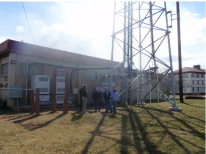
AA-093057 – New Cingular Wireless (PCS) has applied for a new BLM authorization to construct two cabinets and to co-locate on the existing ACS lattice tower system adjacent to Building 652 (Figure 1). The existing site consists of a 10-foot by 10-foot area used by ACS. ACS’s area includes a two cabinets and an 80-foot lattice tower. New Cingular Wireless is requesting a new 12-foot by 15-foot space adjacent to the existing ACS system at Building 652 to install two new cabinets and to collocate a wireless antenna system on the existing ACS lattice tower. The requested lease term is 20 years with an option to renew. The lease area facilities would be operated year round. Site construction could be completed within 90 days. No temporary work areas are anticipated.
Figure 1. Site of AA-093057 and AA-093089.
AA-093089 – Verizon Wireless has applied for a BLM authorization for a new 18-foot by 32-foot lease area for the placement of an equipment shelter for a cellular antenna system (Figure 1). Verizon Wireless would collocate cellular antennas on the existing ACS lattice tower and place two cabinets adjacent to ACS’s and New Cingular Wireless’ proposed (see AA-093057) lease area at Building 652. The requested lease area would consist of an 18-foot by 32-foot flat area with an elevated steel platform and equipment cabinets. The requested lease term is 20 years with an option to renew. The lease area facilities would be operated year round. Verizon Wireless anticipates that site construction could be completed within 30 days. No temporary work areas are anticipated.
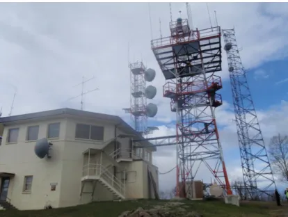
AA-093090 - Verizon Wireless has applied for a BLM authorization for a new 18-foot by 32-foot lease area for the placement of an equipment shelter for cellular antennas. Verizon Wireless would collocate cellular antennas on an existing AT&T cellular tower and place ancillary
equipment adjacent to AT&T’s lease area. Verizon Wireless’s requested lease area would
consist of an 18-foot by 32-foot flat area with an elevated steel platform and equipment cabinets. The requested lease term is 20 years with an option to renew. The lease area facilities would be operated year round. Verizon Wireless anticipates that site construction could be completed within 30 days. No temporary work areas are anticipated.
Figure 2. Site of AA-093090.
AA-092901 – New Cingular Wireless has applied for a BLM authorization to cover an existing cellular tower and ground facilities. The existing facilities include an 83-foot AT&T antenna tower located across from the First Street Building 969B. The tower and ground equipment cabinets are located inside a fenced 20-foot by 20-foot equipment space. The facility is
unmanned and operates 24 hours a day, seven days a week. No new construction is anticipated at this site. ATT is currently awaiting renewal Army’s license of this site (this site was originally licensed to Dobson Communication Systems in 2005).
2.3 Required Operating Procedures, Environmental Protection Measures, and Other Conditions of the Proposed Action Alternative
The following best management practices and design features will be used to limit the effects associated with the current proposed action.
Cultural Resources
In the event of inadvertent discovery of cultural resources or human remains, all construction activities must cease and the BLM Archaeologist must be notified immediately.
Hazardous Materials
Spill response kits and properly trained response personnel will be available on site during all installation activities
The use of drip pans under parked equipment is encouraged to mitigate damage caused by spills.
Recreation Resources
Avoid development near hiking trails or trailhead/parking access.
Avoid development near popular hunting and fishing parking and access areas.
Avoid construction during moose draw tag hunts in unit 14C from September 6 – January 15 (per 2012 regulations, subject to change).
Avoid development in or near Hillberg Ski Area on old Elmendorf or Arctic Valley Ski Area on old Fort Richardson.
Avoid proximity to stream corridors that support local fisheries.
Vegetation Resources
Effectively integrate invasive species prevention, control and management activities into the existing communication tower sites as well as proposed new tower site(s).
Integrate invasive species prevention, detection and control activities into all on-the-ground activities on and near the proposed communication site towers.
Use best management practices to avoid the introduction of new and spread of known existing non-native invasive species as described in the BLM Alaska Invasive Species Management Policy (BLM 2010).
All vehicles, transport equipment used in access, construction, maintenance and operations of project must be thoroughly cleaned prior to moving equipment and gear from point of origin to project site.
Only certified weed free products, including gravel, top soil, seed mixes, mulch and sedimentation control devices are allowed.
Integrated pest management activities including early detection rapid response, prompt revegetation of disturbed sites, ongoing monitoring and weed treatment should be employed to maintain the natural diversity and ecological site health.
Visual Resources
Exhaust all possible co-location options before proposing new facilities.
Avoid hauling excess earth cut or fill, utilize curvilinear or topographical sloping, retain existing rock and vegetation formations whenever possible, irregular rock cut techniques, and prohibit dumping or sloughing of material downslope.
Retain as much existing vegetation as possible, use vegetation to screen development from view, scalloped and irregular edging versus straight lines, and feather and thin edges of cleared areas.
Repeat line, form, color, and texture. Minimize the number of structures, use earth-tone colors, use self-weathering materials, use natural stone, bury all or part of the structure, use paint finishes with low reflectivity, employ native building materials, and use naturally-appearing forms to complement landscape character.
Avoid colors that cause the most contrast, choose colors two to three shades darker than background colors, achieve best blending with surrounding landscape in all seasons,
galvanized steel on utility structures should be darkened to prevent glare, and color (hue) is most effective within 1,000 feet. Grey is usually the best choice for lattice and/or monopole towers where the background may be a view of the sky.
For new roads, trails, and utility corridors, identify all possible alternative alignments first, select the most feasible for the proposed project, use topography to hide manmade changes, analyze soil stability, determine revegetation plan, evaluate hydrologic condition and erosion potential, use curvilinear landscape route selection, avoid fall-line cuts and bisection ridge tops, avoid valley bottoms, and hug vegetation lines
Reclamation and restoration will be required as part of all proposed action design packages. Restore all areas of disturbance as closely as possible to previous conditions, mulch cleared areas, furrow slopes, use planting holes on cut/fill slopes to retain water, choose native plant species; fertilize, mulch, and water vegetation; replace soil, brush, rocks, forest debris, etc. over the disturbed area. Require the contractor to water vegetation for specified timeframe.
3.0 AFFECTED ENVIRONMENT
3.1 Cultural Resources
AA-093057 and AA-093089
The Alaska Heritage Resources Survey (AHRS) was consulted for cultural resources that could
be affected by this undertaking. Because this tower is located in an older part of Fort
Richardson, and within the Fort Richardson Historic District, there are over two dozen cultural
resources within one mile of the APE. Almost all of these are buildings located within the
boundaries of the Fort Richardson Historic District, ANC-1338.
The BLM AFO archaeologist visited the project site on 5/7/2012 and conducted a reconnaissance
of the area. No previously unknown cultural resources were found; the proposed APE is located
on a graded lawn area that has been previously disturbed.
AA-093090
The AHRS was consulted for cultural resources that could be affected by this undertaking.
There are six cultural resources listed in the AHRS within approximately 0.5 miles of the Area of
This communication site is located on Elmendorf Air Force Base, and most of the sites listed in the AHRS are associated with World War II activities at the base.
The BLM AFO Archaeologist visited the proposed APE on 5/7/2012 and found no previously unknown cultural resources present. The proposed tower site is located in a previously disturbed area.
AA-092901
The AHRS was consulted for cultural resources that could be affected by this undertaking. Because this tower is located in an older part of Fort Richardson, and within the Fort Richardson Historic District, there are over two dozen cultural resources within one mile of the APE. All of these are buildings located within the boundaries of the Fort Richardson Historic District, ANC-1338.
The BLM AFO archaeologist visited the project site on 5/7/2012 and conducted a reconnaissance of the area. No previously unknown cultural resources were found.
3.2 Recreation
Recreation opportunities within the highly-developed, residential areas of JBER include bicycling, pick-up basketball, or walking and running for exercise.
Recreation opportunities within the undeveloped areas of JBER include access and parking at trailheads, hiking trails, hunting, skiing on Arctic Valley or Hillberg Ski Areas, and fishing.
3.3 Vegetation Resources, including Invasive Species
Botanical surveys from 1999, 2007, and 2011 identified several non-native invasive species are known to exist on JBER in the vicinity of the proposed communication sites (Alaska Natural Heritage Program 2012). Table 2 lists the non-native plant species found on JBER.
Additionally, two maps (attached) indicate the location of known, existing non-native species relative to the pending communication sites; however, it is likely the populations have spread beyond these known occurrences into surrounding lands.
Table 2. Invasive species known to occur on JBER in proximity to the proposed communication site rights-of-way.
Scientific Name Common Name
Alopecurus pratensis L. meadow foxtail
Anthemis cotula L. mayweed chamomile
Berteroa incana (L.) DC. hoary false madwort
Bromus inermis Leyss. smooth brome
Bromus tectorum L. cheatgrass
Caragana arborescens Lam. Siberian peashrub
Capsella bursa-pastoris (L.) Medik. shepherd's purse
Cerastium fontanum Baumg. ssp. vulgare (Hartm.) Greuter & Burdet big chickweed
Cerastium tomentosum L. snow in summer
Chenopodium album L. lambsquarters
Scientific Name Common Name
Cirsium arvense (L.) Scop. Canada thistle
Crepis tectorum L. narrowleaf hawksbeard
Elymus repens (L.) Gould quackgrass
Erucastrum gallicum (Willd.) O.E. Schulz common dogmustard
Galeopsis tetrahit L. brittlestem hempnettle
Hieracium aurantiacum L. orange hawkweed
Hieracium piloselloides Vill. tall hawkweed
Hieracium umbellatum L. narrowleaf hawkweed
Hordeum jubatum L. foxtail barley
Leontodon autumnalis L. fall dandelion
Lepidium densiflorum Schrad. common pepperweed
Leucanthemum maximum (Ramond) DC. shasta daisy
Leucanthemum vulgare Lam. oxeye daisy
Leucanthemum vulgare Lam. oxeye daisy
Linaria pinifolia (Poir.) Thellung pineneedle toadflax
Linaria vulgaris P. Mill. yellow toadflax
Lolium multiflorum Lam. Italian ryegrass
Lolium multiflorum Lam. Italian ryegrass
Lupinus polyphyllus Lindl. bigleaf lupine
Silene chalcedonica (L.) E. H. L. Krause maltesecross
Matricaria discoidea DC pineappleweed
Melilotus alba Medikus white sweetclover
Papaver croceum Ledeb. Icelandic poppy
Papaver rhoeas L. corn poppy
Persicaria maculosa Gray spotted ladysthumb
Phalaris canariensis L. annual canarygrass
Phleum pratense L. timothy
Plantago major L. common plantain
Poa annua L. annual bluegrass
Polygonum aviculare L. prostrate knotweed
Poa compressa L. Canada bluegrass
Poa pratensis L. ssp. irrigata (Lindm.) H. Lindb. or Poa pratensis L. ssp.
pratensis spreading bluegrass or Kentucky bluegrass
Prunus padus L. European bird cherry
Rumex acetosella L. common sheep sorrel
Rumex crispus L. curly dock
Senecio vulgaris L. common groundsel
Sisymbrium altissimum L. tumbling mustard
Silene latifolia Poir. bladder campion
Sorbus aucuparia L. European mountain ash
Sorbaria sorbifolia (L.) A.Braun false spiraea
Spergula arvensis L. corn spurry
Spergularia rubra (L.) J.& K. Presl red sandspurry
Stellaria media (L.) Vill. common chickweed
Taraxacum officinale F.H. Wigg. common dandelion
Trifolium aureum Pollich golden clover
Trifolium hybridum L. alsike clover
Scientific Name Common Name
Trifolium pratense L. red clover
Trifolium repens L. white clover
Veronica peregrina ssp. peregrina L. neckweed
Vicia cracca L. ssp. cracca bird vetch
Source: Alaska Natural Heritage Program 2012
3.4 Visual Resources
The JBER lands fall under the direction within the Ring of Fire Management Plan. Visual Resource Management (VRM) direction for JBER lands falls under the VRM Class IV objective that “provides for management activities that would make major modifications to the existing character of the landscape; [whereby] change may be very high and while reflecting the basic elements of the landscape, may dominate the view,” (BLM, 2008).
Scenic Quality
The scenic quality within JBER ranges from: lowlands characterized by swampy bogs and small creek channels that mainly feed Eagle River and Ship Creek and support riparian willow, alder, and black spruce communities; to the foothills of the Chugach Mountains with forest patches of spruce; to mid-level Chugach Mountains with more birch and aspen; to alpine peaks and ridges that surround Arctic Valley Ski Area and make up the headwaters of Ship Creek.
The scenery within JBER’s developed areas ranges from small military outpost buildings with cleared lawns, fence, road, and a few outbuldings to highly modified residential and business districts. These areas are characterized by man-made structures, storefronts, visible utilities, asphalt roads, parking lots, lawns, and other areas cleared of vegetation for developments. On the Elmendorf Air Force Base side, topographical relief is more limited than the Chugach mountains and foothills on the Fort Richardson Army Base side of JBER. From the Elmendorf-side, the distant view may include a distinct forested line, or row of trees, and depending upon
topography, the distant Chugach Mountains. All communications sites in this proposed action occur within highly developed areas of JBER.
The scenery within JBER’s undeveloped areas generally depends upon the elevation viewed, but can be pristine and devoid of human development. The norm would more likely include a view, or evidence nearby, of man-made structures. Even in less developed areas, it would be common to find military artifacts and remnants from previous military developments.
Sensitivity Level
Sensitivity levels, or concern for scenic quality varies according to the audience. JBER lands are managed primarily for military operations and support, though considerations should be made for adjacent residents and landowners.
The sensitivity level from residents who live adjacent to JBER may be affected by the nature and extent of future proposed actions that would affect their scenic quality. Additionally, the
bikers, berry pickers, hikers, skiers at Arctic Valley Ski Area, skiers at Hillberg Ski Area, hunters, and fisherman.
The non-resident sensitivity level from visitors to the Anchorage-area would be influenced by the expectations and nature of their visit. The visual resource is very important to visitors who recreate on public lands as well as the commercial businesses that serve them. Most visitors are attracted to the area’s wildlife, fishery, topography, and scenery. Commercial tour companies who cater to Anchorage day-hikers rely upon new and returning visitors as a source of income. The sensitivity of adjacent land management agencies including Chugach State Park, the
Municipality of Anchorage, and the Bureau of Land Management; is driven by how consistent the JBER’s management objectives are with the neighboring agency’s resource objectives. Visual resources are important to the visitors of neighboring Chugach State Park, Far North Bicentennial Park, and BLM Campbell Tract.
Distance Zones
Travel within JBER most commonly occurs in vehicles on roadways. To a lesser degree,
recreational travel may occur on bicycles, on foot, or on skis. Common key observation points or travel routes would therefore include the roadways, the ski areas, trails, and common off-trail ridges that are hiked.
3.5 Wildlife Resources
Much of JBER is relatively undeveloped and provides important habitat for local wildlife
species. JBER is home to abundant populations of moose, black and brown bears, wolves, small game, bald eagles, loons, rainbow trout, all five species of Pacific salmon and the beluga whale, the only threatened or endangered species found on the installation. JBER provides habitat for 39 species of mammals, 162 species of birds, 12 species of fish and 1 amphibian.
The footprints of each of the four communications sites in the proposed action are in located in previously developed/urban areas where wildlife habitats have been altered or removed.
4.0 ENVIRONMENTAL EFFECTS
Unless otherwise noted, the geographic scope of the cumulative effects analysis is defined by the JBER boundary. The temporal scope of the cumulative effects analysis is difficult to pinpoint but, in general, encompasses the period of time in which the modern base facilities have been constructed or built-out through the term of the proposed right-of-way authorizations (i.e., 20 years).
4.1 Cultural Resources
Because the No Action Alternative includes minimal ground disturbance, this action would have
no potential to effect cultural resources. Because the site at AA-093091 is previously disturbed,
reclamation of this site would have no effect on cultural resources.
Given that there are no direct or indirect effects to cultural resources, there is no potential for
cumulative effects as a result of the No Action Alternative.
Proposed Action
AA-093057
The proposed APE is located on a graded lawn area that is previously disturbed, and therefore
will not have any direct impact on cultural resources. While this proposed action is just slightly
within the boundaries of the Fort Richardson Historic District, there is already a communication
site present, along with several utility boxes. Therefore, building a new equipment pad would
not create an adverse visual impact on these cultural resources.
AA-093089
While this proposed action is just slightly within the boundaries of the Fort Richardson Historic
District, there is already a communication site present, along with several utility boxes.
Therefore, building a new equipment pad would not create an adverse visual impact on these
cultural resources. AA-093090
There are no cultural resources within the proposed APE, and therefore there will be no direct
impacts on cultural resources. Because there are existing modern communication towers and
other industrial infrastructure already present at this location, this action would not have an
adverse visual effect on these cultural resources. This action will bring the ROW for the tower
into compliance with BLM regulations. By collocating, Verizon is minimizing new ground
disturbance and visual impacts. AA-092901
Because this is an administrative action for an existing tower with no ground disturbance
proposed, and power lines, roads, fencing, and other industrial infrastructure are already present,
this action will not have an adverse direct or indirect effect on cultural resources.
Because of the extremely small amount of ground disturbance under the Proposed Action (less
than one acre), there will be no cumulative effects on cultural resources.
4.2 Recreation
No Action Alternative
There would be a beneficial effect on the recreation opportunities offered within the developed areas of JBER as it would not approve three new and one existing development and would remove the one existing communications tower. This action would decrease one communication tower viewed by those who live and recreate in the developed areas of JBER.
There may be a beneficial effect on the recreation resource within the undeveloped areas of JBER, if one existing tower is removed. Otherwise, denying the three new communication site authorizations would have no effect on existing recreation opportunities.
There would be no Cumulative Effect if the three new developments are not approved and one existing communications tower is removed. Although this alternative would result in less tower on JBER, this tower to be removed is not in an area that is heavily used by recreationists nor would the removal of this one tower make a noticeable difference on the landscape. Proposed Action
For the three actions requesting to co-locate on existing towers, there would be no additional effect to recreation resources.
The existing, currently unauthorized tower would have no effect upon the recreation opportunities in the developed area. Furthermore, recreation opportunities are limited in proximity to this tower site.
The co-location of cell antennas on existing towers would not contribute to cumulative effects to recreation resources on JBER. However, over time, with the approval of more projects, there may be a cumulative impact to the recreation opportunities offered on JBER if future structures (i.e., structures for military and/or public purposes) and/or new communication towers inhibit access to recreational areas for hiking, berry picking, skiing, hunting, or fishing. In addition, the number of structures may dominate the vistas from hiking trails or ski trails.
4.3 Vegetation Resources, including Invasive Species
No Action Alternative
Invasive species are typically introduced to otherwise weed-free sites by being transported on heavy equipment, tools, and/or gravel and top soil that is brought onto a new construction site. In addition, existing populations of invasive species have the tendency to thrive and spread when the ground they are growing in is disturbed by construction equipment, tools, and increased traffic. Additional non-native invasive species can be introduced in the soil of landscaping vegetation used in site reclamation.
Under the No Action Alternative, the removal and site reclamation of one existing
communication site (AA-092901) would involve a moderate level of ground disturbance which could lead to the introduction and/or invigoration of non-native invasive species. However, with implementation of the required best management practices for all ground disturbing activities described in Section 2.3, the environmental consequences would be minimized and thus the potential for ecological harm reduced and/or prevented.
If other unauthorized existing communication sites are identified and removed, the potential for introduction and spread of non-native invasive plants still exists, but could be minimized through the application of best management practices to protect ecologic integrity.
Due to the scale of the alternative’s footprint, the cumulative effects of the No Action Alternative are discussed together with the cumulative effects of the Proposed Action Alternative.
Proposed Action
The proposed action is subject to the terms and best management practices described in the BLM AK 2010 Invasive Species Management Policy. This policy requires invasive species prevention, control and management to prevent environmental degradation to all BLM authorized activities. There would be no direct or indirect effects to vegetation resources, including potential for invasive species, as a result of approving the existing communication site (AA-092901).
The approval of the three new communication sites with new pads would involve a small amount of ground disturbance to accommodate new pad facilities (less than 0.03 acres cleared
permanently). Heavy equipment and increased vehicular and pedestrian traffic from construction activities at new sites, albeit co-located, would provide favorable conditions for the introduction and spread of non-native invasive species. However, environmental degradation would be minimized and prevented by employing best management practices (as described in Section 2.3 and in the BLM AK 2010 Invasive Species Management Policy) to effectively integrate invasive species prevention, control and management into the existing communication tower sites as well as the proposed new tower site(s).
The environmental impacts relating to non-native invasive species resulting from the management of existing populations (or preventing new introductions) at existing
communication sites (proposed action) would be less than the impacts from the removal and reclamation of the communication site facilities (no action alternative).
Overall, the potential cumulative effects resulting from either alternative is limited. The footprints of disturbance under each alternative are less than a half-acre (0.5-acre) in total. At this scale, and with implementation of best management practices for the proposed action, neither of these alternatives is likely to contribute any measurable increment to cumulative effects on the vegetation resource overall at JBER.
4.4 Visual Resources
No Action Alternative
There would be a beneficial effect, although minor, on the visual resource within the developed areas of JBER because the No Action alternative would remove one existing communication tower. The denial of the three new authorizations would have no effect on visual resources on JBER. Since the existing scenery would be retained with no further modifications.
This action would have no effect upon the undeveloped areas of JBER.
There would be no Cumulative Effect if the three new developments are not approved and one existing communications tower is removed. Although this alternative would result in one less tower on JBER, the tower to be removed is in an area that is heavily developed; the removal of this one tower would not make a noticeable difference on the landscape.
Proposed Action
Under the Proposed Action Alternative (Alternative #2), the BLM would approve four communication site applications that would each be constructed within the already highly developed areas of JBER. Three of these actions involve co-location of facilities on existing structures; therefore, there would be no effect to visual resources as a result of these actions. The fourth action occurs in an area that is highly developed with many man-structures visible. The direct and indirect effects of this action would be minimal.
The Proposed Action Alternative would have no effect to the undeveloped areas of JBER as all proposed actions would be constructed in the developed areas of JBER.
Over time, with the approval of more projects, there may be a cumulative impact to the visual resource if future structures dominate views from undeveloped areas, such as hiking trails on ridges with a view impeded by structures.
4.5 Wildlife Resources
No Action Alternative
There would be beneficial effect to wildlife resources within the developed areas of JBER as it would remove one existing communications tower. This action would reduce the amount of development and removal of vegetation and its associated impacts to wildlife. These effects would however be minimal as the tower to be removed is in a previously disturbed area. Proposed Action
For the three actions requesting to co-locate on existing towers, there would be no additional effect to wildlife resources, as they occur in previously disturbed areas and have minimal impacts to wildlife due to the removal of habitat.
The authorization of the existing unauthorized tower would have no effect on wildlife resources in the developed area, as no new disturbance or removal of vegetation would take place.
Since there is no potential for direct or indirect effects to wildlife as a result of this action, there is no potential for this project to incrementally contribute to cumulative effects to wildlife on JBER.
5.0 CONSULTATION AND COORDINATION
This EA was prepared by an interdisciplinary team consisting of the following staff: Jenny Blanchard BLM, Archaeologist
Brian Bourdon BLM, Lands and Realty Specialist
Molly Cobbs BLM, Planning and Environmental Coordinator Jorjena Daly BLM, Outdoor Recreation Planner
Bruce Seppi BLM, Wildlife Biologist Laurie Thorpe BLM, Natural Resources Specialist
References Cited
BLM. 2010. BLM – Alaska Invasive Species Management Policy.
Alaska Natural Heritage Program. 2012. Alaska Exotic Plants Information Clearinghouse (AKEPIC), http://aknhp.uaa.alaska.edu/maps/akepic/
Council on Environmental Quality. 2012. Draft Guidance: Improving the Process for Preparing Efficient and Timely Environmental Reviews under the National Environmental Policy Act, January 2012.
S 0 1 5 N 0 0 3 W
A
T
&
T
,
A
A
-9
2
9
0
1
V
e
ri
z
o
n
W
ir
e
le
s
s
,
A
A
-9
3
0
8
9
V
e
ri
z
o
n
W
ir
e
le
s
s
,
A
A
-0
9
3
0
9
0
A
T
&
T
,
A
-9
3
0
5
7
A
n
c
h
o
ra
g
e
E
a
g
le
R
iv
e
r
Kn
ik
Ar
m
G
le
nn
H
ig
hw
ay
F
t
R
ic
h
a
rd
s
o
n
F
t
R
ic
h
a
rd
s
o
n
E
lm
e
n
d
o
rf
A
F
B
S 0 1 4 N 0 0 2 W S 0 1 4 N 0 0 3 W S 0 1 3 N 0 0 2 W S 0 1 3 N 0 0 3 W S 0 1 5 N 0 0 2 W S 0 1 4 N 0 0 1 W L e g e n d Jo in t B a se Elme n d o rf/Rich a rd so n (JB ER) T o wn sh ip & Ra n g e 0 0 .6 1 .2 1 .8 2 .4 3 0 .3 M ile s D iscl a im e r: T h e in fo rm a ti o n d isp la ye d o n th is m a p sh o u ld b e u se d fo r g ra p h ic d isp la y o n ly . F o r o ff ici a l l a n d st a tu s in fo rm a ti o n , re fe r to C a d a st ra l S u rv e y p la ts, M a st e r T it le P la ts a n d la n d st a tu s ca se -f ile s. Z :\ p ro je ct s\ JB E R \N E P A _ C o m m u n ica to n _ S it e s_ B o u rd o n _ A p ri l2 0 1 2S
0
1
3
N
0
0
3
W
A
T
&
T
,
A
A
-9
2
9
0
1
V
e
ri
z
o
n
W
ir
e
le
s
s
,
A
A
-9
3
0
8
9
A
T
&
T
,
A
-9
3
0
5
7
S
0
1
4
N
0
0
3
W
S
0
1
4
N
0
0
2
W
S
0
1
3
N
0
0
2
W
3
1
3
2
6
3
6
5
1
3
0
2
5
L e g e n d Kn o wn Occu rre n ce s o f In va sive W e e d s T o wn sh ip & Ra n g e T o wn sh ip & Ra n g e Se ctio n s 0 0 .1 0 .2 0 .3 0 .4 0 .5 0 .0 5 M ile s D iscl a im e r: T h e in fo rm a ti o n d isp la ye d o n th is m a p sh o u ld b e u se d fo r g ra p h ic d isp la y o n ly . F o r o ff ici a l l a n d st a tu s in fo rm a ti o n , re fe r to C a d a st ra l S u rv e y p la ts, M a st e r T it le P la ts a n d la n d st a tu s ca se -f ile s. Z :\ p ro je c ts \J B E R \N EP A_ C o m m u n ic a to n _ Si te s _ B o u rd o n _ Ap ri l2 0 1 23
V
e
ri
z
o
n
W
ir
e
le
s
s
,
A
A
-9
3
0
9
0
S
0
1
4
N
0
0
3
W
S
0
1
3
N
0
0
3
W
3
3
3
2
4
2
8
3
4
2
9
5
2
7
L e g e n d Kn o wn Occu rre n ce s o f In va sive W e e d s T o wn sh ip & Ra n g e T o wn sh ip & Ra n g e Se ctio n s 0 0 .1 0 .2 0 .3 0 .4 0 .5 0 .0 5 M ile s D iscl a im e r: T h e in fo rm a ti o n d isp la ye d o n th is m a p sh o u ld b e u se d fo r g ra p h ic d isp la y o n ly . F o r o ff ici a l l a n d st a tu s in fo rm a ti o n , re fe r to C a d a st ra l S u rv e y p la ts, M a st e r T it le P la ts a n d la n d st a tu s ca se -f ile s. Z :\ p ro je c ts \J B E R \N EP A_ C o m m u n ic a to n _ Si te s _ B o u rd o n _ Ap ri l2 0 1 2APPENDIX A
Description of Communications Site Uses
Broadcast Uses
AM and FM Radio Broadcast (AM, FM). This category includes facilities licensed by the Federal Communications Commission (FCC) that broadcast AM and FM audio signals for general public reception and the communications equipment directly related to the operation, maintenance, and monitoring of the use. Users include radio stations that generate revenues from commercial advertising and public radio stations whose revenues are supported by subscriptions, grants, and donations. Broadcast areas often overlap State boundaries. This category of use relates only to primary transmitters and not to any rebroadcast systems such as translators, microwave relays serving broadcast translators, or holders licensed by the FCC as low power FM radio.
Broadcast Translator, Low Power Television, and Low Power FM Radio (BT, LPTV, LPFM). This category of use consists of FCC-licensed translators, low power television (LPTV), low power FM radio (LPFM), and communications equipment directly related to the operation, maintenance, or monitoring of that use. Microwave facilities used in conjunction with the systems are included in this category. Broadcast translators receive a television or FM radio broadcast signal and rebroadcast it on a different channel or frequency for local reception. In some cases the translator relays the signal to another amplifier or translator. LPTV and LPFM radio stations are broadcast translators that originate programming. This category of use includes translators associated with a public telecommunications service.
Cable Television (CT). This category includes FCC-licensed facilities that transmit video programming to multiple subscribers in a community over a wired or wireless network, and the communications equipment directly related to the operation, maintenance, or monitoring of the use. These systems normally operate as a commercial entity within an authorized franchise area. This category does not include rebroadcast devices or personal or internal antenna systems, such as private systems serving hotels or residences.
Television Broadcast (TV). This category includes facilities licensed by the FCC that broadcast UHF and VHF audio and video signals for general public reception and the
communications equipment directly related to the operation, maintenance, and monitoring of the use. Users include television stations (major and independent networks) that generate income through commercial advertisement and public television stations whose operations are supported by subscriptions, grants, and donations. Broadcast areas may overlap State boundaries. This category of use relates only to primary transmitters and not to any rebroadcast systems such as translators, transmitting devices such as microwave relays serving broadcast translators, or holders licensed by the FCC as low power television (LPTV).
Non-Broadcast Uses
Cellular Telephone and Personal Communications Services (CEL). Cellular telephone and PCS include holders of FCC-licensed systems and related technologies for mobile
communications that use a blend of radio and telephone switching technology to provide public switched network services for fixed and mobile users within a geographic area. These systems