ANNEX 7
DRAFT E-NAVIGATION STRATEGY IMPLEMENTATION PLAN
Introduction
1 As shipping moves into the digital world, e-navigation is expected to provide digital information and infrastructure for the benefit of maritime safety, security and protection of the marine environment, reducing the administrative burden and increasing the efficiency of maritime trade and transport.
2 The e-navigation Strategy Implementation Plan (SIP) introduces a vision of e-navigation which is embedded in general expectations for the on board, onshore and communications elements.
3 The main objective of the present SIP is to implement the five prioritized e-navigation solutions, taking into account the IMO Formal Safety Assessment (FSA), from which a number of required tasks have been identified. These tasks should, when completed in the period 2015–2019, provide the industry with the harmonized information, in order to start designing products and services to meet the e-navigation solutions.
4 The present SIP identifies the list of tasks which would need to be performed during the coming years in order to achieve the five prioritized e-navigation solutions.
5 It should be noted that, although the need to use the existing equipment in a more holistic way was identified early on, some onboard equipment may need modifications to interfaces and controls in order to be used. However, in the future, the need for new equipment for the deployment of future e-navigation solutions and applications cannot be disregarded.
6 Tasks listed in the SIP should be incorporated in the High-level Action Plan of the Organization as planned/unplanned outputs, taking into account the provisions of the Guidelines on the organization and method of work of the Maritime Safety Committee and the Marine Environment Protection Committee and their subsidiary bodies, as set out in MSC-MEPC.1/Circ.4/Rev.2, as may be revised (the Committee's Guidelines).
7 In line with the provisions of the Committee's Guidelines, any further e-navigation-related work would require the Committee's approval and should be clearly incorporated as planned/unplanned output(s) in the High-level Action Plan of the Organization. Therefore, each one of the approved tasks would need to be approved at the same time as a planned/unplanned output, as appropriate, with clear indication of:
- IMO's objectives; - Analysis of the issue; - Analysis of implications; - Compelling need; - Benefits;
- Industry standards; - The intended output;
- Human element consideration;
- Priority/urgency, including expected target completion year; and - Action required.
8 In line with the above, interested Member States may submit proposals to the Committee for the inclusion of new planned/unplanned outputs in the High-level Action Plan of the Organization based on the identified tasks contained in this SIP.
9 Proposals for the further development of e-navigation solutions and tasks which are not listed in the SIP may also be submitted by Member States to the Committee for consideration; however priority should be given to the tasks identified in the SIP.
10 Member States willing to lead a specific task should ensure the timely delivery of the task by requesting the assistance of other Member States and/or relevant organizations. Strategy Implementation Plan for the five prioritized e-navigation solutions
11 The present SIP is based on the following five prioritized e-navigation solutions: S1: improved, harmonized and user-friendly bridge design;
S2: means for standardized and automated reporting;
S3: improved reliability, resilience and integrity of bridge equipment and navigation information;
S4: integration and presentation of available information in graphical displays received via communication equipment; and
S9: improved Communication of VTS Service Portfolio (not limited to VTS stations).
12 Solutions S2, S4 and S9 focus on efficient transfer of marine information and data between all appropriate users (ship-ship, ship-shore, shore-ship and shore-shore). Solutions S1 and S3 promote the workable and practical use of the information and data on board. 13 As part of each one of the above prioritized e-navigation solutions, several sub-solutions were identified. These are illustrated in tables 1 to 5 below.
14 Whilst the first steps involve implementing the five prioritized e-navigation solutions, it is important to recognize that further e-navigation development will be a continuous process following user needs for additional functionalities of existing and possible future systems (e.g. implementation of onboard and/or ashore navigational decision support systems). As user needs evolve and new technology is introduced, other e-navigation solutions may be incorporated into the strategy, as appropriate.
15 During the FSA process, the following Risk Control Options (RCOs) were identified in order aid the assessment of the prioritized e-navigation solutions and some of the sub-solutions:
RCO 1: Integration of navigation information and equipment including improved software quality assurance (related to sub-solutions S1.6, S1.7, S3.1, S3.2, S3.3, S4.1.2, and S4.1.6);
RCO 4: Automated and standardized ship-shore reporting (related to sub-solutions S2.1, S2.2, S2.3 and S2.4);
RCO 5: Improved reliability and resilience of onboard PNT systems (related to sub-solution S3.4);
RCO 6: Improved shore-based services (related to sub-solution S4.1.3 and solution S9); and
RCO 7: Bridge and workstation layout standardization (related to sub-solution S1.1).
16 A number of necessary actions and tasks have been identified in order to progress the further development and implementation of the five prioritized e-navigation solutions. These are listed below under each respective solution and consolidated in table 7.
Table 1
Required regulatory framework and technical requirements for implementation (tasks) for solution 1 (Improved harmonized and user friendly bridge design)
Sub-Solution
Description Task Action Task
Identifier (Table 7) S1.1 Ergonomically improved and
harmonized bridge and workstation layout.
Draft Guidelines on Human Centred Design (HCD) for e-navigation systems.
Draft Guidelines on Usability testing, Evaluation and Assessment (UTEA) for e-navigation systems.
Resolutions A.694(17), A.997(25) and MSC.252(83) and MSC/Circ.982, SN.1/Circ.265, SN.1/Circ.274 and SN.1/Circ.288 are of relevance.
T1
T2
S1.2 Extended use of
standardized and unified symbology for relevant bridge equipment.
Develop symbology for relevant equipment using as a reference resolution MSC.192 (79).
T2
S1.3 Standardized manuals for
operations and
familiarization to be provided in electronic format for relevant equipment
Develop the concept of electronic manuals and harmonize the layout to provide mariner with an easy way of familiarization for relevant equipment.
T3
S1.4 Standard default settings, save/recall settings, and S-mode functionalities on relevant equipment.
Performance or technical standards mandating the features on relevant equipment. Develop a testbed demonstrating the whole concept of standardized modes of operation including store and recall for various situations as well as S-mode functionality on relevant equipment.
T4
S1.5 All bridge equipment to follow IMO BAM (Bridge
Ensure that all equipment is checked during type approval and that it meets
Sub-Solution
Description Task Action Task
Identifier (Table 7) Alert Management)
performance standard.
the requirements of resolution MSC.302(87) on Bridge Alert Management, as may be updated. S1.6 Information
accuracy/reliability indication functionality for relevant equipment.
Develop a testbed demonstrating technically how accuracy and reliability of navigation equipment may be displayed.
T6
S1.6.1 Graphical or numerical presentation of levels of reliability together with the provided information.
From the above develop a harmonized display system indicating reliability levels.
T6
S1.7 Integrated bridge display system (INS) for improved access to shipboard information.
INS systems which integrate navigation equipment data already exist but are not mandatory carriage to resolution MSC.252(83). E-navigation relies on integration and without mandatory carriage of INS it would be difficult to achieve the solutions. The carriage of an INS or maybe something simpler performing integration should be investigated.
T7
S1.8 GMDSS equipment
integration – one common interface.
Take into account resolution A.811(19) when integrating GMDSS into one common interface.
(Already in hand)
Table 2
Required regulatory framework and technical requirements for implementation (tasks) for solution 2 (Means for standardized and automated reporting)
Sub-Solution
Description Task Action Task
Identifier (Table 7) S2.1 Single-entry of reportable information in single-window solution.
Develop testbeds demonstrating the use of single window for reporting along with S2.4.
T8 T15
S2.2
Automated collection of internal ship data for reporting.
Much data is already collected in the navigation equipment – investigate the use of this data for reporting of ship navigational information.
T9 S2.3 Automated or semi-automated digital distribution/communication of required reportable information, including both "static" documentation and
Review the original AIS long range port facility as well as the new long range frequencies made available at WRC 2012 described in the latest revision of ITU-R M.1371-5, the
revised IEC 61993-2, or the T9 T15
Sub-Solution
Description Task Action Task
Identifier (Table 7) range port was not used during the
development of LRIT due to the cost to shipowners of sending this information.
S2.4
All national reporting requirements to apply standardized digital reporting formats based on recognized internationally harmonized standards, such as IMO FAL Forms or SN.1/Circ.289.
Liaise with all Administrations and agree on standardized formats for ship reporting so as to enable "single window" worldwide. In this respect national and regional harmonization is the first step.
Table 3
Required regulatory framework and technical requirements for implementation (tasks) for solution 3 (Improved reliability, resilience and integrity of bridge equipment and
navigation information)
Sub-Solution
Description Task Action Task
Identifier (Table 7)
S3.1
Standardized
self-check/built-in integrity test (BIIT) with interface for relevant equipment
(e.g. bridge equipment).
Equipment should be developed with standardized BIIT built in. The general requirements in resolution A.694(17) as tested by IEC 60945 should be investigated to see if more definition and testing is required.
T10
S3.2
Standard endurance, quality and integrity verification testing for relevant bridge equipment, including software.
Software quality assurance especially lifetime assurance methods need to be developed into draft guidelines.
The type approval process needs to be developed further to ensure that the equipment used in e-navigation is robust in all aspects.
T11
T11
S3.3
Perform information integrity tests based on integration of navigational equipment – application of INS integrity monitoring concept.
This task is very similar to that described for S1.6 and S1.6.1.
T6
S3.4
Improved reliability and resilience of onboard PNT information and other critical navigation data by integration with and backup of by integration with external and internal systems.
IMO is already drafting performance standards for a multi system navigational receiver designed to use all available systems for an improved and more reliable PNT solution. There may be traditional methods and other terrestrial systems which should also be investigated as the external input. Backup arrangements for critical foundation data, particularly in the event of interruption to cloud based solutions should be investigated. Administrations need to indicate their support for terrestrial systems.
Table 4
Required regulatory framework and technical requirements for implementation (tasks) for solution 4 (Integration and presentation of available information in graphical
displays received via communication equipment)
Sub-Solution
Description Task Action Task
Identifier (Table 7) S4.1 Integration and presentation of
available information in graphical displays (including MSI, AIS, charts, radar, etc.) received via communication equipment.
The INS has a display that could be used for displaying this information. Work done by IALA et al show that extra information on existing displays such as ECDIS and Radar might obliterate key critical information on these displays.
Investigate and demonstrate via a testbed the integration and portrayal of this information and draft guidelines on how it should be done in a harmonized way. Resolution MSC.252(83) and SN.1/Circ.268 are related.
T13
S4.1.1 Implement a Common Maritime Data Structure and include parameters for priority, source, and ownership of information.
CMDS is at the heart of e-navigation. It has been already agreed to use the IHO S-100 data model. Develop both the shore based data models and also the shipboard data models including firewalls, as necessary, and harmonize via the IMO-IHO harmonization group on data modelling.
T14
S4.1.2 Standardized interfaces for data exchange should be developed to support transfer of
information from
communication equipment to navigational systems (INS).
Most equipment already uses one of the IEC 61162 series interface standards, although IMO only refer to it by footnote. The testing standards for shipboard equipment developed by IEC all refer to this standard. IEC should make sure that at the highest level the interfaces meet the S100 principle although it may not be necessary to use this standard between simple equipment.
T14
S4.1.3 Provide mapping of specific services (information available) to specific regions (e.g. maritime service portfolios) with
status and access
requirements.
Ensure that the correct and up-to-date information for the area of operation are provided by the shore side and that the mariner gets the information for the area of operation.
Sub-Solution
Description Task Action Task
Identifier (Table 7) MSI could be viewed on relevant
or defined displays as ECDIS or RADAR or on INS task displays. S4.1.4 Provision of system for
automatic source and channel management on board for the selection of most appropriate
communication means
(equipment) according to criteria as, band width, content, integrity, costs.
Least cost routing systems are available and could be demonstrated. The communication means should be transparent to the user. However, the real task is identifying the currently available communications systems and how they can be used (range, bandwidth, etc.) and what systems are being developed and will be in use when e-navigation is live. The task should look at short range systems such as VHF, 4G and 5G.
T15
S4.1.5 Routing and filtering of information on board (weather, intended route, etc.).
Investigate the performance standard of the current INS and see how these facilities can be implemented in a preliminary new draft.
T7
S4.1.6 Provide quality assurance process to ensure that all data is reliable and is based on a consistent common reference system (CCRS) or converted to such before integration and display.
Ensure data quality and CCRS are met with new Quality Assurance.
T11
S4.1.7 Implement harmonized presentation concept of information exchanged via communication equipment including standard symbology and text support taking into account human element and ergonomics design principles to ensure useful presentation and prevent overload.
Harmonize displays. T6
T13
S4.1.8 Develop a holistic presentation library as required to support accurate presentation across displays.
Harmonize displays. T6
S4.1.9 Provide Alert functionality of INS concepts to information
Ensure that all bridge equipment meets the Bridge Alert
Sub-Solution
Description Task Action Task
Identifier (Table 7) S4.1.10 Harmonization of conventions
and regulations for navigation and communication equipment.
The task to go through all the IMO performance standards may be very large. It would be advisable to draft an "e-navigation enabling Performance Standard" which would identify the changes to interfaces, control symbology and other details which would be used as an add on for approval for use in e-navigation.
Table 5
Required regulatory framework and technical requirements for implementation (tasks) for solution 9 (Improved communication of VTS service portfolio
(not limited to VTS stations))
Solution Description Task Actions Task
Identifier (Table 7) S9 Improved communication of
VTS service portfolio (not limited to VTS stations)
Communications is a key factor in the e-navigation concept. This task needs to identify the possible communications methods that might be used and testbeds need to be built to demonstrate which systems are best in different areas of operation. (e.g. deep sea, coastal and port).
If the delivery of MSPs was to be cloud based then this task should report on what is available and where and who is responsible for the cloud or clouds.
Much of this work is appropriate to S4.1.4.
T15 T17
Maritime Service Portfolios (MSPs)
17 As part of the improved provision of services to vessels through e-navigation, MSPs have been identified as the means of providing electronic information in a harmonized way, which is part of solution 9. The proposed list of MSPs is presented in table 6 below. Further information about MSPs is set out in annex 2. The further development of the MSPs is task T17.
18 The following six areas have been identified for the delivery of MSPs: .1 port areas and approaches;
.2 coastal waters and confined or restricted areas; .3 open sea and open areas;
.4 areas with offshore and/or infrastructure developments; .5 Polar areas; and
Table 6
List of proposed MSPs
No Identified Services Identified Responsible Service Provider MSP1 VTS Information Service
(IS)
VTS Authority MSP2 Navigational Assistance
Service (NAS)
National Competent VTS Authority/Coastal or Port Authority
MSP3 Traffic Organization Service (TOS)
National Competent VTS Authority/Coastal or Port Authority
MSP4 Local Port Service (LPS) Local Port/Harbour Operator MSP5 Maritime Safety Information
Service (MSI
National Competent Authority MSP6 Pilotage service Pilot Authority/Pilot Organization
MSP7 Tugs Service Tug Authority
MSP8 Vessel Shore Reporting National Competent Authority, Shipowner/Operator/Master
MSP9 Telemedical Assistance
Service (TMAS)
National Health Organization/dedicated Health Organization
MSP10 Maritime Assistance
Service (MAS)
Coastal/Port Authority/Organization
MSP11 Nautical Chart Service National Hydrographic Authority/ Organization
MSP12 Nautical Publications
Service
National Hydrographic Authority/ Organization
MSP13 Ice Navigation Service National Competent Authority Organization MSP14 Meteorological Information
Service
National Meteorological Authority/WMO/ Public Institutions
MSP15 Rea-time Hydrographic and Environmental Information Service
National Hydrographic and Meteorological Authorities
MSP16 Search and Rescue Service SAR Authorities Development of related guidelines
19 The combination of the five e-navigation solutions supported by the FSA, and the three guidelines, Guidelines on Human Centred Design (HCD) for e-navigation, Guidelines on Usability Testing, Evaluation and Assessment (U-TEA) for e-navigation systems and Guidelines for Software Quality Assurance (SQA) in e-navigation, proposes an e-navigation implementation that facilitates a holistic approach to the interaction between shipboard and shore-based users.
20 The development of an e-navigation reference model for the five solutions, including possible proposed legal framework, governance structures and funding models for relevant infrastructures, could involve establishing a globally cooperating network of regional testbeds.
21 During the development of e-navigation, the use of testbeds has been valuable. e-navigation testbeds could be pivotal to the progressive implementation of e-navigation solutions. It would be advisable that, where possible, there should be international cooperation in the establishment of testbeds. International cooperation could be seen as vital to ensure that e-navigation solutions can successfully operate on a global scale and to leverage the benefits of pooled resources and expertise.
22 Further testbeds may be used and evaluated and it has been identified that guidelines on the reporting need to be drafted so that the results can be presented in a harmonized way. These guidelines have been added to the task list as task T18.
Identification of tasks, deliverables and schedule
23 Table 7 outlines the identified tasks with a short definition including deliverables and transition arrangements, if necessary, and an indication of the prioritized implementation schedule
Table 7
Tasks, expected deliverables, transition arrangements and implementation schedule Task
No
Task Expected Deliverable Transition
Arrangements
Prioritized Implementation
Schedule T1 Development of draft Guidelines on Human Centred
Design (HCD) for e-navigation systems.
Guidelines on Human Centred Design (HCD) for e-navigational systems.
None 2014/2015
T2 Development of draft Guidelines on Usability Testing, Evaluation and Assessment (UTEA) of e-navigation systems.
Guidelines on Usability Testing, Evaluation and Assessment (UTEA) of e-navigation systems.
None 2014/2015
T3 Develop the concept of electronic manuals and harmonize the layout to provide mariner with an easy way of familiarization for relevant equipment.
Guidelines on electronic equipment manuals.
Provide existing manuals as .pdf
2019
T4 Formulate the concept of standardized modes of operation, including store and recall for various situations, as well as S-mode functionality on relevant equipment.
Guidelines on S-mode. None 2017
T5 Investigate whether and extension of existing Bridge Alert Management Performance Standards (PS) is necessary. Adapt all other alert relevant PSs to the to Bridge Alert Management PS.
(a) Guidelines on implementation of Bridge Alert Management.
(b) Revised Performance Standards on BAM.
None None
2016 2019 T6 Develop a methodology of how accuracy and
reliability of navigation equipment may be displayed. This includes a harmonized display system.
Guidelines on the display of accuracy and reliability of navigation equipment.
Task No
Task Expected Deliverable Transition
Arrangements
Prioritized Implementation
Schedule T7 Investigate if an INS, as defined by resolution
MSC.252(83), is the right integrator and display of navigation information for e-navigation and identify the modifications it will need, including a communications port and a PNT module. If necessary, prepare a draft revised performance standard. Refer to resolution MSC.191(79) and SN/Circ.243.
(a) Report on the suitability of INS. (b) New or additional modules for the Performance Standards for INS.
None None
2016 2019
T8 Member States to agree on standardized format guideline for ship reporting so as to enable "single window" worldwide (SOLAS regulation V/28, resolution A.851(20) and SN.1/Circ.289)
Updated Guidelines on single window reporting.
National/Regional Arrangements
2019
T9 Investigate the best way to automate the collection of internal ship data for reporting including static and dynamic information.
Technical report on the automated collection of internal ship data for reporting.
None 2016
T10 Investigate the general requirements resolution A.694(17) and IEC 60945 to see how Built In Integrity Testing (BIIT) can be incorporated.
(a) Revised resolution on the general requirements including Built In Integrity Testing.
(b) Revised IEC Standard on General Requirements including Built In Integrity Testing.
None
None
2017
Task No
Task Expected Deliverable Transition
Arrangements
Prioritized Implementation
Schedule T11 Development of draft Guidelines for Software Quality
Assurance (SQA) in e-navigation. This task should include an investigation into the type approval process to ensure that software lifetime assurance (software updates) can be carried out without major re-approval and consequential additional costs. Refer to SN/Circ/266/Rev.1 and MSC.1/Circ.1389.
Guidelines for Software Quality Assurance (SQA) in e-navigation.
None 2014/2015
T12 Develop guidelines on how to improve reliability and resilience of onboard PNT systems by integration with external systems.
Liaise with Administrations to ensure that relevant shore-based systems will be available.
Guidelines on how to improve reliability and resilience of onboard PNT systems by integration with external systems.
None 2016
T13 Develop guidelines showing how navigation information received by communications equipment can be displayed in a harmonized way and what equipment functionality is necessary.
Guidelines on the harmonized display of navigation information received from communications equipment.
None 2019
T14 Develop a Common Maritime Data Structure and include parameters for priority, source, and ownership of information based on the IHO S-100 data model. Harmonization will be required for both use on shore and use on the ship and the two must be coordinated (Two Domains).
Develop further the standardized interfaces for data exchange used on board (IEC 61162 series) to support transfer of information from communication equipment to navigational systems (INS) including appropriate firewalls (IEC 61162- 450 and 460).
(a) Guidelines on a Common Maritime Data Structure.
(b) Further develop the IEC standards for data exchange used onboard including firewalls.
None
Use latest IEC standards
2017
Task No
Task Expected Deliverable Transition
Arrangements
Prioritized Implementation
Schedule T15 Identify and draft guidelines on seamless integration
of all currently available communications infrastructure and how they can be used (e.g. range, bandwidth, etc.) and what systems are being developed (e.g. maritime cloud) and could be used for e-navigation.
The task should look at short range systems such as VHF, 4G and 5G as well as HF and satellite systems taking into account the 6 areas defined for the MSPs.
Guidelines on seamless integration of all currently available communications infrastructure and how they can be used and what future systems are being developed along with the revised GMDSS. Use existing onboard communications infrastructure 2019
T16 Investigate how the Harmonization of conventions and regulations for navigation and communication equipment would be best carried out. Consideration should be given to an all-encompassing e-navigation performance standard containing all the changes necessary rather than revising over 30 existing performance standards.
Report on the Harmonization of conventions and regulations for navigation and communication equipment would be best carried out.
None 2017
T17 Further develop the MSPs to refine services and responsibilities ahead of implementing transition arrangements.
Resolution on Maritime Service Portfolios.
National/Regional Arrangements
2019
T18 Development of Draft Guidelines for the Harmonization of testbeds reporting.
Guidelines for the Harmonization of testbeds reporting.
24 The following table shows the timelines for each task and an indication of the schedule to clarify common understanding necessary for the implementation.
Table 8
Indication of the schedule to clarify common understanding necessary for the implementation 2014 2015 2016 2017 2018 2019 2020 T1 T2 T3 T4 T5(a) T5(b) T6 T7(a) T7(b) T8 T9 T10(a) T10(b) T11 T12 T13 T14(a) T14(b) T15 T16 T17 T18
Relevant key enablers for e-navigation
25 During the development of the SIP, a number of actions have been identified as key enablers for e-navigation. Some of them are listed below.
Table 9
Examples of key enablers of e-navigation
Key Enabler INITIAL ACTION status
Globally Standardized Data Exchange
Data providers to adapt to IMO recognized data standards such as IHO's S-100 data model IMO/IHO harmonization group set up A harmonized data communication standard
International organizations with industry; IALA is developing a VHF data Exchange System (VDES) and working with ITU
Ongoing
Maritime Service Portfolios Defining: IMO See Task T17 Providers and onboard
systems for resilient PNT
IMO is developing Performance Standards for multi-system navigation receiver PS
Ongoing
Connect all relevant
equipment and
functionality
IEC is developing a family of standards including a firewall with the support of the industry
Ongoing
Software Quality
Assurance
Guidelines to be developed Ongoing Ensure that relevant
e-navigation functions will be accepted as complying with the relevant IMO performance standards for shipborne navigational and radiocommunications equipment
NCSR Sub-Committee to undertake as need arises
See Task T16
Connect all relevant
equipment and
functionality for VTS
Member States to address individually. IALA and IEC may assist in developing standards
Ongoing
Coastal States to provide the required infrastructure
IALA, IHO and CIRM may assist in developing required infrastructure, including relevant standards
Ongoing
Establish Human Centred Design principles
Continue to refine INS and IBS performance standards and guidelines respectively
Ongoing
Description of the ship and shore architecture for the prioritized solutions
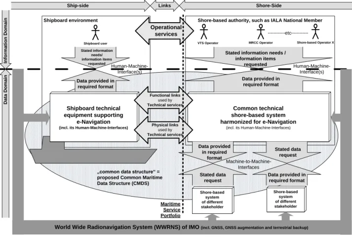
26 Figure 1 shows the principle of an information/data flow in the e-navigation architecture. The figure shows the complete overarching e-navigation architecture, and
27 The architecture also:
.1 brings into focus the "operational service" level and the "Functional links used by Technical services" and the "Physical links used by Technical services";
2 highlights the fundamental distinction between information and data domains, explaining the relationship between the user requested information items and introducing the concepts of Operational and Technical Services, as well as Functional and Physical Links into a hierarchical perspective;
.3 identifies the concept of "Maritime Service Portfolios"; and .4 unfolds the relationship of shore-to-shore data exchange.
28 The detailed shore and ship side architecture will be further developed in the light of the completion of some of the relevant tasks.
Shipboard environment Shore-based authority, such as IALA National Member
Shipboard user VTS Operator MRCC Operator Shore-based Operator X
etc Shore-based system of different stakeholder Shore-based system of different stakeholder
Ship-side Links Shore-Side
In fo rm a ti o n D o m a in D a ta D o m a in Common technical shore-based system harmonized for e-Navigation
(incl. its Human-Machine-Interfaces)
Shipboard technical equipment supporting
e-Navigation (incl. its Human-Machine-Interfaces)
Data provided in required format Stated information needs/ information items requested Data provided in required format
Stated information needs / information items requested Operational services Stated data request Data provided in required format Data provided in required format Stated data request Machine-to-Machine-Interfaces Human-Machine-Interface(s) Human-Machine-Interface(s)
World Wide Radionavigation System (WWRNS) of IMO (incl. GNSS, GNSS augmentation and terrestrial backup)
„common data structure“ = proposed Common Maritime Data Structure (CMDS) Functional links used by Technical services Physical links used by Technical services Maritime Service Portfolio
Figure 1 – Overarching e-navigation architecture Identification of communication systems for e-navigation
29 Communications are a key for e-navigation. Any communications systems used must be able to the deliver appropriate MSPs in the 6 areas defined, as per S9, as well as delivering reliable ship reporting as identified in S2.
30 Existing available communications can be broadly divided into those:
.1 used for distress and safety-related communications such as for the promulgation of maritime safety information (MSI), as is currently mandated by GMDSS, and AIS; and
.2 commercially available systems, such as various satellite solutions (e.g. Inmarsat, Iridium and VSAT) as well as terrestrial telephone and data networks, such as GSM / 3G /4G.
31 Future communication systems could include VHF data (VDES) and NAVDAT, and be developed for internet based solutions, such as a maritime cloud, facilitating system wide information management solutions.
32 Existing and future communication links could be integrated via a maritime intranet, although each technical service will be limited by the capabilities of the available communication links. This infrastructure will primarily be based on IP communications links but will enable the utilization of free communication links for safety and mandatory reporting where appropriate, enabling a seamless integration and transition between available communications technologies.
33 The gap analysis, when considering effective and robust shipboard communications, identified that communications system should be developed in the future based on IP technology.
34 Relevant requirements for commercial communication links for e-navigation should have certain availability and latency criteria for the defined service area, and should provide a two-way data communication channel, enabling acknowledgement of information delivery. 35 This could enable automatic quality assurance of:
.1 service efficiency;
.2 availability and coverage of the communication service; and .3 the shipborne communication installation and capability.
36 It is envisaged that the majority of communication for various MSPs would be needed as a vessel approaches the coast and, therefore, it is likely that more bandwidth/speed may be needed in these areas.
37 Task T15 addresses these issues and is critical to the implementation of e-navigation. The ability to send, receive and quality assure the MSPs depends on the availability of the right solution here.
38 The possible further development of the existing LRIT shore-based infrastructure has the potential to provide a data link between authorities ashore using secure communications links, for use in certain MSPs, (as an example MSP16 (search and rescue)). This does not impact on the mandatory LRIT ship reporting system nor does it add to the ship to shore cost for an LRIT message.
Proposals on enhancing public awareness of the e-navigation concept to key stakeholder and user groups
40 E-navigation is relevant and important to a broad range of stakeholders. The aim of the proposals on enhancing awareness of the e-navigation concept is to improve the overall knowledge of the e-navigation concept among different stakeholders, and to enlist their cooperation and assistance in the implementation of e-navigation.
41 In this respect, five stakeholder groups have been identified as important and influential recipients, including key messages for each e-navigation solution. The key messages should be actively used to inform different stakeholders of the potential outcome and benefits of e-navigation, as well as the process of implementing e-navigation.
42 The development of an e-navigation website is also proposed in order to provide a coordinated and dynamic approach for distributing and sharing information related to the further development of e-navigation.
43 Regional/technical cooperation activities could be held in various parts of the world to promote and provide information on the status of the implementation of e-navigation initiatives. It would also provide a meeting arena for knowledge exchange on the process. 44 An e-navigation communication plan is provided in annex 3.
Regulatory impact
45 The provision and further development of e-navigation should consider relevant international conventions, regulations and guidelines, national legislation and standards. The development and implementation of e-navigation should build upon the work of IMO1.
46 E-navigation is intended to be based on the use of the existing equipment, however any changes in carriage requirement for some of the elements needed to make the system work may have an impact on ship certification.
47 Certain elements in the e-navigation strategy plan have not yet been fully investigated as they depend on the outcome of some of the tasks.
Funding
48 Solution 2 (Means for standardized and automated reporting) and Solution 9 (improved communication of VTS service portfolio) both refer to improved shore based facilities which may need funding for e-navigation to be successfully implemented for some stakeholders.
49 The funding could comprise two components split between regional and international contributions. The former being normally provided by participating Government agencies or National or regional grants and the latter by donors operating under the support of an institution such as the World Bank or National Agencies for international development assistance. The funding can be grants, loans or important technical advisory services.
50 There are in addition bilateral agreements between regions and countries which may contribute to successful funding of e-navigation solutions.
1
Including, but not limited to, the requirements prescribed in FAL, SOLAS, MARPOL and STCW conventions.
51 The identification of potential sources of funding for development and implementation, particularly in developing regions and countries and of actions to secure that funding, including resource management, could, as an example, usefully look at previous successfully funded international maritime projects.
52 According to World bank statistics, in the case of the Marine Electronic Highway (MEH) in the Straits of Malacca and Singapore, the budget was $17 million which was split as 51% regional (Littoral States and private) and 49% international (GEF/World Bank as grants for IMO and Indonesia).
ANNEX 1
Background information related to the identified Risk Control Options (RCOs)
1 Relevant background information related to the Risk Control Options (RCOs) identified during the Formal Safety Assessment (FSA) is provided in the following paragraphs. RCO 1: Integration of navigation information and equipment including improved software quality assurance
2 There is a potential for various navigational information to be available in an increasingly centralized way enabling presentation on relevant task orientated workstations. This may reduce workload and otherwise ease the task of navigation.
3 Sophisticated bridge navigational systems are increasingly integrated with each other and with other kinds of systems on the ship. This, as well as the implicit ability of these systems to influence each other, increases complexity. As such it is of increasing importance that these systems are usable, available, reliable and resilient.
RCO 2: Bridge alert management
4 On a bridge with no centralized alert management system, problems in properly identifying alerts may arise. Additionally, alerts from various sources may not be prioritized by importance with regards to safe navigation. Potentially unnecessary distractions of the bridge team by redundant and superfluous audible and visual alarm announcements may occur, increasing the cognitive load on the operator.
5 The relevant performance standards in relation to central alert management are specified in resolutions MSC.252(83) on Adoption of the revised performance standards for Integrated Navigation Systems (INS) and MSC.302(87) on Adoption of performance standards for Bridge Alert Management.
RCO3: Standardized mode(s) for navigation equipment
6 In order to aid the navigator, and also to gain commercial advantage, the navigation equipment manufacturers and suppliers are continuously developing their products to include a rapidly increasing number of sophisticated functionalities. As the different suppliers follow different generation and presentation philosophies, and in part different terminology, this introduces the risk of navigators or pilots not being able to access or use all the available functions, not being able to produce a familiar setup of the equipment, and consequently not being able to obtain information required for navigational decision-making.
7 Safe navigation relies on the ability of key personnel of the bridge team to easily operate navigational equipment as well as to comprehend the information that is presented to them. Without proper familiarization, which can sometimes take a significant period of time due to the current differences between operating systems, this is not always the case when someone is new to a particular setup. Lack of familiarity with bridge equipment which can result in slow responses due to not finding correct information, system, control function or alarm is therefore likely to adversely affect safe navigation.
8 Standard modes or default display configurations are envisaged for relevant navigational equipment. Such standard modes should be selectable at the task station and would reset presentation and settings of information to provide a standardized and common display familiar to all users. The standard mode should be accessible by a simple operator
action. The standard or default settings would act as a starting point for a user to build the optional settings appropriate for a particular task. Those optional settings could be then saved by the user and be recalled later by a single operator action.
9 Standardized information presentation, symbols and coding should be used according to resolution MSC.191(79) on Performance standards for the presentation of navigation-related information on shipborne navigational displays. There should be a standard or default user interface mode (accessible by a simple operator action) and associated display configuration for relevant navigational equipment.
RCO 4: Automated and standardized ship-shore reporting
10 A potential for reducing workload due to filling out and delivering reportable information has been identified. Forms are usually manually filled out and sent individually to each authority requesting the information. Compliance with IMO FAL forms normally takes about two hours to complete. Thus a significant potential for reduction in paper work and administration exists.
11 Standardized ship-shore electronic reporting has been the subject of recent work done by the Facilitation Committee and by the European Commission.
RCO 5: Improved reliability and resilience of onboard PNT systems
12 The primary aim of position fixing is to ensure a ship is correctly following its passage plan. Systems such as Global Navigational Satellite Systems (GNSS) provide position, and timing information. Other information can be derived from multiple position fixes and timing such as, velocity or course and speed over the ground. Changes in velocity over time can also yield other information such as rate of turn. Together this set of information is commonly referred to as Position Navigation and Timing (PNT). Ensuring reliable and resilient PNT data is particularly important for safe navigation at sea.
13 Resilience is the ability of a system to detect and compensate for external and internal sources of disturbances, malfunction and breakdowns in parts of the system. Achieving resilient PNT does not imply any setting up of additional GNSS or terrestrial systems, but may use information from such systems should they exist. Reliability is the probability that the PNT system, when it is available, performs a specified function without failure under given conditions for a specified time.
14 Provision of resilient PNT information can be achieved through a combination of existing space-based and terrestrial systems, modernized and future radio navigation systems, ship-based sensors and other services.
15 Caution must be exercised against the use of differing systems for PNT in different regions of the world. Such a move would potentially create circumstances resulting in new risks for navigation, as mariners will potentially need to change their practices when travelling between regions. Another issue is that ships could be optimized to navigate only in particular regions with certain types of PNT solutions. This also could impact upon achieving a uniform training regime for seafarers. The implementation of e-navigation should as much as possible employ a consistent approach to the provision of PNT for marine navigation worldwide.
17 It is evident there are some good candidates to assist with resilient PNT on board that, alongside GNSS and some potential regional systems could provide resilient PNT. They are:
.1 inertial navigation systems;
.2 signals of opportunity, such as radio, radar, sonar, echo sounder, etc.; .3 electronically-enabled human-observed bearings and distances (i.e.
modern electronic coastal navigation using an e-pelorus, radar and ECDIS);
.4 autonomous celestial navigation; and
.5 other possibilities that could arise from research, for example in the areas of defence and robotic vehicle navigation.
RCO 6: Improved shore-based services
18 VTSs, ports and other shore-based stakeholders gather and hold a lot of information regarding navigational warnings, incidents, operations, tide, AIS, traffic regulations, chart updates, meteorological conditions, ice conditions, etc., which is often referred to as the Maritime Service Portfolio.
19 Implementation of a system for automatic and digital distribution of shore support services would make information more available, updated and relevant for navigators. 20 Firstly, Maritime Safety Information (MSI) received by the ship should be relevant to the ship's specific voyage. Today, broadcasted MSI delivered as printed text from a NAVTEX receiver and must be considered for action. As the Officer of Watch (OOW) may potentially receive several MSI messages daily, of which a large portion of the messages may not be of concern to the voyage, there is the risk of missing vital MSI. Important MSI could easily be overlooked. The MSI should be displayed in relation to the information it relates to and is being used on the bridge in the correct place.
21 Secondly, notices to mariners, updates to ENC's and corrections to all nautical publications should be received electronically without any delays in the delivery. Distribution via post is time consuming and may introduce risks to the ships sailing in waters, for which the nautical charts are not up to date.
22 As e-navigation evolves, broadband communications needs to become more cost-effective and readily available. Changes that should be made to current regulatory regimes (e.g. performance standards) so that new systems can be included should be done in a structured way. This will ensure their use is compliant with the various existing navigational equipment and services, whilst not limiting the possibilities for new approaches that could offer benefits such as reduced costs and improvements in efficiency and effectiveness. 23 The most appropriate platform to present MSI may be either the INS tasks route monitoring and status and data display (resolution MSC.252(83)) or the ECDIS unit and optionally on another navigational display. Notices to Mariners, updates and corrections to ENCs and all nautical publications should be able to be received electronically with minimal delay in delivery. Such updates and corrections should, in the future, fully integrated into the INS tasks route monitoring and status and data display (resolution MSC.252(83)) or the ECDIS unit and optionally on another navigational display. Thus, such updates and corrections should not be reliant on formats such as pdf or require the navigator to manually transfer updates and corrections between source and navigation device.
RCO 7: Bridge and workstation layout standardization
24 Cumbersome equipment layout on the bridge adversely influences the mariner's ability to optimally perform navigational duties. Although some good bridge layout designs exist with respect to ergonomics, this is an area identified as insufficiently regulated so as to ensure a consistent acceptable level of functionality.
25 Reference could be made to SOLAS regulation V/15 on Principles relating to bridge design, design and arrangement of navigational systems and equipment and bridge procedures, MSC/Circ.982 on Guidelines on Ergonomic Criteria for Bridge Equipment and Layout, SN.1/Circ.265 on Guidelines on the Application of SOLAS regulation V/15 to INS, IBS and bridge design, SN.1/Circ.288 on Guidelines for bridge equipment and systems, their arrangement and integration (BES) and ISO8468 on Ships Bridge layout and associated equipment.
26 Document NAV 59/6/1 (Australia) related to "Design Usability Principles for e-navigation Solutions and Risk Control Options" is relevant to this RCO, along with the application of Human Centred Design (HCD) guidelines and the Usability (UTEA) guidelines. 27 Seafarers may experience difficulties in accessing necessary information because of ergonomic problems, such as inappropriate physical bridge locations of navigational equipment. Ergonomic problems of navigation equipment also exist in the sense that there is a lack of intuitive human-machine interface for communication and navigation means. Bridge layouts, equipment and systems have not been consistently and sufficiently designed from an ergonomic and usability perspective. Lack of familiarity with bridge equipment and/or slow response due to not finding correct information/control/alarm is considered to adversely affect safe navigation.
ANNEX 2
A detailed explanation of the Maritime Service Portfolios No Identified Services Identified Service Provider Short Description MSP1 VTS Information Service (IS)
VTS Authority The VTS Information Service (IS) is defined as "a service to ensure that essential information becomes available in time for onboard navigational decision making".
Relevant information is broadcasted at fixed times and intervals or provided when deemed necessary by the VTS or at the request of a vessel.
A VTS IS involves maintaining a traffic image and allows interaction with traffic and response to developing traffic situations. An Information Service should provide essential and timely information to assist the onboard decision-making process, which may include but is not limited to:
the position, identity, intention and destination of vessels;
amendments and changes in promulgated information concerning the VTS area such as boundaries, procedures, radio frequencies, reporting points;
the mandatory reporting of vessel traffic movements;
meteorological and hydrological conditions, notices to mariners, status of aids to navigation;
manoeuvrability limitations of vessels in the VTS area that may impose restrictions on the navigation of other vessels, or any other potential hindrances; or
any information concerning the safe navigation of the vessel.
The VTS IS is designed to improve the safety and efficiency of vessel traffic and to protect the environment. Among others, such services include catalogue such as: Routing, Channel info, Security level, Berthing, Anchorage, Time slot, Traffic monitoring and assessment, Waterway conditions, Weather, Navigational hazards, any other factors that may influence the vessel's transit, Reports on the position, Identity and intentions of other traffic.
No Identified Services Identified Service Provider Short Description MSP2 Navigational Assistance Service (NAS) National Competent VTS Authority/ Coastal or Port Authority
The NAS is defined as "a service to assist onboard navigational decision-making and to monitor its effects".
NAS may be provided on request by a vessel in circumstances such as equipment failure or navigational unfamiliarity.
Specific examples of developing situations where NAS may be provided by the VTS include: Risk of grounding; Vessel deviating from the recommended track or sailing plan; Vessel unsure of its position or unable to determine its position; Vessel unsure of the route to its destination; Assistance to a vessel to an anchoring position; Vessel navigational or manoeuvring equipment casualty; Inclement conditions (e.g. low visibility, high winds); Potential collision between vessels; Potential collision with a fixed object or hazard; Assistance to a vessel to support the unexpected incapacity of a key member of the bridge team, on the request of the master.
MSP3 Traffic Organization Service (TOS) National Competent VTS Authority/Coastal or Port Authority
The TOS is defined as "a service to prevent the development of dangerous maritime traffic situations and to provide for the safe and efficient movement of vessel traffic within the VTS area". The purpose of the TOS is to prevent hazardous situations from developing and to ensure safe and efficient navigation through the VTS area.
TOS should be provided when the VTS is authorized to provide services, such as when: vessel movements need to be planned or prioritized to prevent congestion or
dangerous situations;
special transports or vessels with hazardous or polluting cargo may affect the flow of other traffic and need to be organized;
an operating system of traffic clearances or sailing plans, or both, has been established; the allocation of space needs to be organized;
mandatory reporting of movements in the VTS area has been established; special routes should be followed;
No Identified Services Identified Service Provider Short Description MSP4 Local Port Service (LPS) Local Port/Harbour Operator
LPS is applicable to those ports where it has been assessed that a VTS, as described above, is excessive or inappropriate.
The main difference arising from the provision of LPS is that it does not interact with traffic, nor is it required to have the ability and/or the resources to respond to developing traffic situations and there is no requirement for a vessel traffic image to be maintained.
Provision of LPS is designed to improve port safety and co-ordination of port services within the port community by dissemination of port information to vessels and berth or terminal operators. It is mainly concerned with the management of the port, by the supply of information on berth and port conditions. Provision of LPS can also act as a medium for liaison between vessels and allied services, as well as providing a basis for implementing port emergency plans. Examples of LPS may include:
berthing information; availability of port services; shipping schedules; and
meteorological and hydrological data.
A number of web-based LPS services are being developed. An example is AVANTI, an initiative of the International Harbour Masters Association (IHMA).
MSP5 Maritime Safety Information Service (MSI) National Competent Authority
The Global Maritime Distress and Safety System (GMDSS) as described in SOLAS chapter IV defines the seventh functional requirement as:
"Every ship, while at sea, shall be capable of transmitting and receiving maritime safety information".
The MSI service is an internationally coordinated network of broadcasts of Maritime Safety Information from official information providers, such as:
National Hydrographic Offices, for navigational warnings and chart correction data; National Meteorological Offices, for weather warnings and forecasts;
Rescue Co-ordination Centres (RCCs), for shore-to-ship distress alerts; and the International Ice Patrol, for Oceanic ice hazards.
Specific information on Aids to Navigation and restrictions on safe navigation are part of MSI services provided by National Authorities. This can include but is not limited to, the following
No Identified Services Identified Service Provider Short Description
type of information to be available to mariners: status of Aids to Navigation;
status of GPS and DGPs; buoy tendering operation; and
restriction on safe navigation such as bridge/hydro cable air gap, new hazards, construction or dredging operations.
MSP6 Pilotage Service Pilot Authority/ Pilot
Organization
The aim of the pilotage service is to safeguard traffic at sea and protect the environment by ensuring that vessels operating in pilotage area have navigators with adequate qualifications for safe navigation. Each pilotage area needs highly specialized experience and local knowledge on the part of the pilot.
Efficient pilotage depends, among other things, upon the effectiveness of the communications and information exchanges between the pilot, the master and the bridge personnel and upon the mutual understanding each has for the functions and duties of the other.
The Pilot's Portable Unit (PPU) is a useful tool for safe navigation in clear and restricted visibility. Data accessible by the PPU should be made available in a structured, harmonized and reliable manner, and the interface for accessing such e-navigation information should be standardized. Establishment of effective coordination between the pilot, the master and the bridge personnel, taking due account of the ship's systems and equipment available to the pilot, will aid a safe and expeditious passage (see resolution A.960(23)).
MSP7 Tugs Service Port/Commercial Tug
Organization
Efficient tug operations depend on, among other things, the effectiveness of the communications and information exchanges between relevant stakeholders. The aim of the tugs services is to safeguard traffic at sea and protect the environment by conducting operations such as:
No Identified Services Identified Service Provider Short Description
escort operations; and oil spill response operations. MSP8 Vessel Shore Reporting National Competent Authority, Shipowner/ Operator/Master
The aim of vessel shore reporting is to safeguard traffic at sea, ensure personnel safety and security, ensure environmental protection and increase the efficiency of maritime operations. Single-Window is one of the most important solutions to reduce the Mariners workload (amount of time spent on preparing and submitting reports to shore-based authorities). To achieve this, reports should be automatically generated as much as possible from onboard systems. Some other important possibilities for vessel shore reporting system may include:
single-entry of reportable information in single-window solution; automated collection of internal ship data for reporting;
all national reporting requirements to apply standardized digital reporting formats based on IMO FAL forms; and
automated or semi-automated digital distribution/communication of required reportable information. MSP9 Telemedical Assistance Service (TMAS) National Health Organization/ Dedicated Health Organization
TMAS centres should provide medical advice for seafarers 24 h/day, 365 days/year. TMAS should be permanently staffed by physicians qualified in conducting remote consultations and who are well versed in the particular nature of treatment on board ship.
Within the maritime medicine the prevailing view has for a long time been that a standardization of the TMAS services is both necessary and wanted. This would firstly enhance the quality of the medical practice, and secondly, a standardization of reporting and registering of medical events will make a much better basis for advancement.
MSP10 Maritime Assistance Service (MAS) Coastal/Port Authority/ Organization
The primary mission of MAS is to handle communication between the coastal State, ship's officers requiring assistance and other players in maritime community. These can be fleet owners, salvage companies, port authorities, brokers, etc.
The MAS is on 24-hour alert to deploy rapid assistance and professional support for ships in connection with combating pollution, fire and explosions on board, collision, grounding, maritime security, terror mitigation, etc.
No Identified Services Identified Service Provider Short Description
pirates, etc. On receiving such a call, the MAS is responsible for alerting the relevant authorities responsible for a response.
The MAS is responsible only for receiving and transmitting communications and monitoring the situation. It serves as a point of contact between the master and the coastal State concerned if the ship's situation requires exchanges of information between the ship and the coastal State. Situations where the MAS apply are as follows:
ship involved in an incident (loss of cargo, accidental discharge of oil, etc.) that does impair its seakeeping ability but nevertheless has to be reported;
ship in need of assistance according to the master's assessment, but not in distress situation that requires the rescue of personnel on board; and
ship in distress situation and those on board have already been rescued, with the possible exception of those who have remained aboard or have been placed on board to attempt to deal with the ship's situation.
The MAS entails the implementation of procedures and instructions enabling the forward of any given information to the competent organization and requiring the organizations concerned to go through the MAS in order to make contact with the ship.
MSP11 Nautical Chart Service National Hydrographic Authority/ Organization
The aim of the nautical chart service is to safeguard navigation at sea by providing information such as nature and form of the coast, water depth, tides table, obstructions and other dangers to navigation, location and type of aids to navigation.
The Nautical Chart service also ensure the distribution, update and licensing of electronic chart to vessels and other maritime parties.
MSP12 Nautical Publications Service National Hydrographic Authority/
The aim of the nautical publication service is to promote navigation awareness and safe navigation of ships. The nature of waterways described by any given nautical publication changes regularly, and a mariner navigating by use of an old or uncorrected publication is
No Identified Services Identified Service Provider Short Description MSP13 Ice Navigation Service National Competent Authority Organization
The ice navigation service is critical to safeguard the ship navigation in ice-infested waters, given how quickly the ice maps become outdated in the rapid changing conditions of the ice-covered navigational regions. Such services include:
ice condition information and operational recommendations/advice; ice condition around a vessel;
vessel routing;
vessel escort and ice breaking; ice drift load and momentum; and ice patrol. MSP14 Meteorological Information Service National Meteorological Authority/WMO/ Public Institutions
The meteorological service is essential to safeguard the traffic at sea by providing weather, climate digital forecasts and related information to mariners who will use these types of information to support their decision making. Such information includes:
weather routing, solar radiation and precipitation; cold/hot durations and warnings;
air temperature, wind speed and direction; and cloud cover and barometric pressure.
MSP15 Real-time Hydrographic and Environmental Information Service National Hydrographic and Meteorological Authorities
The real-time hydrographic and environmental information service is essential to safeguard navigation at sea and protect the environment. The services provided are such as:
current speed and direction; wave height;
marine habitat and bathymetry;
sailing Directions (or pilots): detailed descriptions of areas of the sea, shipping routes, harbours, aids to navigation, regulations, etc.;
lists of lights: descriptions of lighthouses and lightbouys; tide surge prediction tables and tidal stream atlases;
ephemerides and nautical almanacs for celestial navigation; and
notice to mariners: periodical (often weekly) updates and corrections for nautical charts and publications.