Page 354 www.ijiras.com | Email: contact@ijiras.com
Refugee Camp Management: A Google Earth Approach
Okusimba George Omusotsi
University of Eldoret, Department of Civil & Structural Engineering, Eldoret, Kenya
I. INTRODUCTION
GIS plays an important role in the overall activities of UNHCR. The products generated by UNHCR’s Geographic Information and Mapping Unit (GIMU) are used by donors, the public, government representatives, implementing partners and UNHCR staff. Three major types of maps are produced by GIMU (UNHCR, 2003). General maps indicate refugee camp locations, office locations and areas of operation. Operation maps are usually more detailed with locations based on GPS recorded by field personnel. Statistical maps illustrate official statistics provided by the registration and statistics unit.
The other types of maps produced are the camp level maps. The value of mapping refugee and IDP camps is to link the geographic databases to the population databases and perform analyses which can inform UNHCR on the level of care being provided to the camp population. In the vast majority of refugee camps, the database used to store and manage information is the ProGres database. It is a complex database used to register refugees as they arrive in a camp and
manage their information for the entire time they are a refugee (UNHCR, 2006(a)).
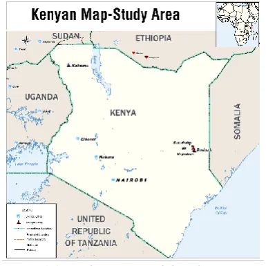
The proper use of GIS with good data can enhance the planning and management of refugee camps. With the background information that those entrusted with the management of refugee camps are not necessarily GIS experts, the level to which they can effectively use GIS in camp management is limited. A project was carried out in 2009 as part of the requirements for the degree of Master of Science in GIS to extent the capability of UNHCR’s GIS system using Google Earth. The study area, Dadaab complex is located in North Eastern province of Kenya close to Kenya-Somalia border and comprises of three camps: Dagahaley, Hagadera and Ifo.
Abstract: Good camp management is essential to ensure that the rights and needs of displaced people living in a camp, refugee or internally displaced, are guaranteed and adhered to. Camp management includes a variety of tasks in different sectors: provision of security, water, food, shelter, health, sanitation, education and other social amenities and often involves many actors, such as the national governments, the local authorities, united nations agencies, non governmental organizations and the displaced persons.
It is always necessary to manage information about who is living in the camp and the infrastructure in the camp. Combined, registration and spatial databases provide critical information that facilitates camp management. Visualizing this information on a map does not only provide the figures and statistics necessary to analyze the situation in the camp, but can also be used to propose solutions.
This study demonstrated how Google Earth can be used to enable refugee camp managers in their daily management activities, allowing for visualization, planning, informed decision making and updating of the data. Based on spatial and aspatial data that existed, Google Earth files were created for the three camps in Dadaab Kenya; Dagahaley, Hagadera and Ifo, incorporating the main features within the camps and shared with one manager at the camp for testing.
Keywords: Google Earth, Refugee Camp Management, Keyhole Markup Language, GIS, Map Layer
Page 355 www.ijiras.com | Email: contact@ijiras.com Figure 1.1: Study Area-Daadab Refugee Camps
It has a refugee population of 235,453 most of who are of Somali origin (UNHCR 2008). This paper presents the methodology adopted and the results of the system developed. It is based mainly on the MSc thesis “Application of Google Earth in refugee camp management” (Okusimba, n.d.).
II. GOOGLE MAPPING OVERVIEW
Google has three main mapping products. Google Maps, Google Mapmaker and Google Earth (GE). Google Maps is viewed via an internet browser, provides two-dimensional data viewing, is light and fast and users must be connected to the internet to view or create their maps. Google Mapmaker provides users with an opportunity to create user generated content that eventually ends up in Google Maps. The motivation for providing this mapping tool was the lack of high quality maps throughout the world, the need for constantly up to date maps in our rapidly changing world and lack of comprehensive local data on roads, places and businesses.
GOOGLE EARTH
GE is an application software that is downloadable for free from the internet and installed on one’s computer running on either windows, linux or macintosh. Once installed, it allows one to view high resolution aerial and satellite imagery, elevation terrain, road and street labels, business listings and much more. (Google, 2007). The components of GE are: GE fusion that integrates raster data, GIS, terrain and point data; GE server responsible for streaming data to the client software and Google Earth EC for viewing, printing and data authoring. GE offers a number of features but the basic features can be classified into mapping, local search and sightseeing.
INSTALLING GE: SYSTEM REQUIREMENTS
To use GE on a Windows PC, you must have at least the following:
Operating System: Windows 2000, Windows XP, Windows Vista
CPU: 500Mhz, Pentium 3
System Memory (RAM): 128MB
Hard Disk: 400MB free space
Network Speed: 128 Kilobits/second
Graphics Card: 3D-capable with 16MB of VRAM
Screen: 1024x768, "16-bit High Color" screen
To use GE on a Mac, you must have at least the following:
Operating System: Mac OS X 10.4 or later
CPU: G3 500Mhz
System Memory (RAM): 256MB
Hard Disk: 400MB free space
Network Speed: 128 Kilobits/second
Graphics Card: 3D-capable with 16MB of VRAM
Screen: 1024x768, "Thousands of Colors"
To use GE on a Linux computer, you must have at least the following:
Kernel 2.4 or later
glibc 2.3.2 w/ NPTL or later
XFree86-4.0 or x.org R6.7 or later
CPU: 500Mhz, Pentium 3
System Memory (RAM): 128MB
Hard Disk: 400MB free space
Network Speed: 128 Kilobits/second
Graphics Card: 3D-capable with 16MB of VRAM
Screen: 1024x768, "Thousands of Colors"
GOOGLE EARTH VERSIONS
There are two versions of GE: Google Earth basic and Google Earth Pro. There is no subscription fee for the basic version and any one can use it as long as they are connected to the internet. It offers 1400 pixel printing resolution, has capability of importing data from GPS receivers and real time GPS tracking functionality is enabled. The following functionalities are available with the GE Pro version that has a licence fee of USD 400 a year:
4800 pixel printing resolution,
GPS and Spreadsheet support,
Area measurements,
Add on capabilities including movie making and traffic data modules,
Importation of MapInfo and ESRI products among others
GOOGLE EARTH FILE TYPES
Page 356 www.ijiras.com | Email: contact@ijiras.com GOOGLE EARTH DATA
GE displays two types of data: Imagery from satellites and aerial photography, and different layers which can be turned on through a side bar on the left side of GE application.
IMAGES
The imagery displayed in GE come from both satellites and aerial photographs. Some of the imagery come from kites and balloons. Google acquires these images from a variety of providers including city or state governments. The age of the imagery varies greatly, but most of the high resolution imagery is between 6 months and 5 years of age. Because the imagery comes from a variety of sources, the process to get this imagery into GE is complex and involves a great deal of time and effort and this explains why the displayed images are not real time. Another reason you do not find imagery that is newer is that it is costly to acquire quality aerial imagery. The companies who spend this money need a way to recover their costs. More recent imagery is more valuable than older imagery. As a result, these companies are reluctant to have their newest imagery available for free for anyone to view on Google Earth. Google has been known to release much more recent imagery in GE for unique events.
Near real-time imagery of the Earth is available in GE. There is the new Clouds layer, found under the Weather layer folder. The clouds are actually taken from weather satellites and are a global picture of the clouds as recent as 3 hours old. NASA has a layer they call Daily Planet which shows the entire Earth at a medium resolution (about 250 meter resolution per pixel) which can be viewed in GE.
The imagery is taken by the MODIS Terra satellite and is processed as quickly as possible and shows the entire Earth between 6 - 12 hours old. The imagery is continuously updated. At the moment, this layer from NASA is the most recent, highest resolution imagery of the Earth continuously updating available to the general public.
With the new Google Earth 5, Google added a new historical imagery feature; you are not limited to just the imagery shown by default in Google Earth. Google has archives of imagery much larger than a single view of any one place. For many places, Google has 2, 3, or even 30 different images over time for any one location.
Figure 2.1: Google Earth Application Interface
GOOGLE EARTH LAYERS
Google Earth has a huge collection of freely available satellite and aerial photos for places all around the world. The imagery database is really huge - millions of square kilometers. A part from the GE imagery, layers are also available through an interface on the lower left side bar of the GE application. And there is as much information in the layers as there is in the imagery.
Layers provide a wealth of information about a variety of subjects, and the layers are also a way for Google to share valuable contributions of information from any individuals and organizations. The layers are organized using a folder-like structure with categories at the high level, and one can open each folder to selectively view sub-layers.
For basic geographic information, the following layers are useful.
Terrain - It is the 3D terrain allowing visualisation of features like mountains, valleys, and canyons.
Roads - Google has detailed roads and streets for many countries
Borders and labels - this lets you see the outlines of countries, island names, coastlines, and administrative orders (states, counties, provinces, etc.).
Populated places - this is what shows the labels and locations for towns and cities world-wide - This layer is found under the Borders and labels layer.
Geographic features - this category contains sub-layers for features like locations of volcanoes, names of mountains, and water bodies. This layer folder is found under the Places of Interest layer folder near the bottom of the list.
Another selection of the layers serve the purpose of highlighting points of interest if one is traveling. This is the same kind of information you get with a modern car navigation device (or GPS) for finding hotels, restaurants, etc. Examples of these kinds of layers in GE are: Dining, Lodging, Shopping and Services, Transportation, Travel and Tourism, Parks and Recreation, and Community Services.
All of the layers mentioned above are useful and important, but the really interesting layers come from a variety of sources not originally maintained or created by Google.
Google recently released the Geographic Web layers which consist of a careful selection of useful information and pictures and references to web-based information on places all over the Earth.
III. METHODOLOGY DATA SOURCES AND MATERIAL
Layer Feature Type Coverage
1 Administrative Polygon Residential Areas
2 Roads Polyline Road Network
3 Water Points/Polygon Water
Points/Lines 4 Facilities Points/Polygon Education,
Page 357 www.ijiras.com | Email: contact@ijiras.com Hospitals,
Mosque, Market, etc Table 3.1: Data Layers
Equipment/Tool/Material Source
1 Computer UNHCR/Personal
2 Software (ArcGIS, MapInfo, GE) UNHCR/Internet
3 Printer UNHCR
4 Data UNHCR
Table 3.2: Equipment, Tools and Material
The production of maps and development and maintenance of geospatial databases are tasks entrusted to GIS Experts within UNHCR. It is apparent that GIS is an indispensable tool in refugee camp management and general operations of UNHCR. Because of limited financial resources and the large amount of money required in setting up new GIS systems, it is important that other ways are sought so that GIS can continue to be a useful tool in refugee camp management even for those who are not GIS experts. Google mapping products are becoming common in daily operations of many people, both those in geospatial industry and those who are not. Google Earth, in particular, is an application software downloadable from the internet which allows one to view high resolution aerial and satellite imagery, elevation terrain, road and street labels, business listings and much more (Google, 2007). Further more, data generated in Google Earth can be integrated in formats readable by conventional GIS software and vice versa. Switching between the different Google mapping products (Google Earth, Google Maps and Google map maker) allows features like editing of spatial data via the web through collaboration and moderation to keep the integrity of the data. This will also control those who edits these data, a tool that can be employed by both GIS experts and refugee camp managers to keep up to datedness of the refugee camp spatial databases.
In its efforts to protect refugees and to promote solutions to their problems, UNHCR works in partnership with governments, regional organizations, international and non-governmental organizations. As such camp management involves players from different organizations, both government and non governmental. The mandate of UNHCR is to coordinate the activities of these many players so that UNHCR’s goals are achieved. A lot of data, both spatial and non-spatial is generated and ends up with UNHCR. It is against this backdrop that a project executed in 2009 had the objectives of cleaning and ordering the existing Dadaab refugee camp data at Regional Support Hub-Nairobi, Kenya; integrating camp administrative unit data, the sectorial facilities data (education, markets, health facilities, water e.t.c) and infrastructure data in order to be able to generate camp overview maps; harmonizing the administrative unit codes and ProGres database codes to enable the production of UNHCR’s standard and indicator maps; exporting the above generated map layers in GE’s KML to enable visualization, further editing and sharing of the products and; testing the system with the intended users at the Dadaab camps.
DATA CLEANING
The objective of carrying out data cleaning was to look at the existing data, identify any gaps, duplication and store it in an orderly and easy to access format. The end product was an easy to access; clean data set for the three camps that was used in the study.
CODE HARMONIZATION
In order to make meaningful integration of refugee population data from ProGres database and the GIS database, a common field must exist in both the databases. ProGres database allocates each block with a unique proGres block ID. The GIS database adopts these proGres block IDs in order to integrate the two databases. A comparison of the two databases revealed that some blocks existed in ProGres database but were missing in the GIS database and vice versa. GENERATION OF CAMP OVERVIEW MAP LAYERS
Camp map layers depict the extents of the blocks in the camp, the sectoral facilities within each block including water, health, sanitation and education among others plus the road networks.
The existing data was used to generate these layers that formed the basis on which the Google Earth layers were established. These layers also reflected the up datedness of the spatial data used by GIS experts at the RSH Nairobi and Headquarters.
GENERATION OF STANDARDS AND INDICATOR MAP LAYERS
The essence of integrating the ProGres and GIS databases was to be able to use the population data to generate thematic and standard & indicator maps. Thematic maps that were produced were: population map showing the refugee population per block, population density map giving an indication of the number of persons per square meter.
With regard to UNHCR standards & indicators, the following maps were created so as to be used to measure the camp’s performance: Population 200m from water points, population per water tap and area per person.
CONVERSION OF MAP LAYERS TO GOOGLE EARTH’S KML/KMZ
Keyhole Markup Language and Keyhole Markup Language Zipped are the data formats used in Google Earth. In order to be able to use the generated map layers in Google Earth, they were converted to GE’s Keyhole Markup Language using tools available in Arc GIS software.
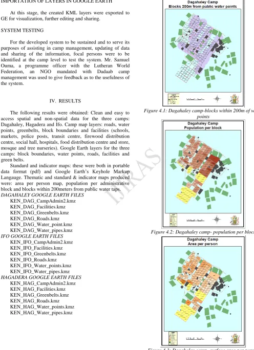
Page 358 www.ijiras.com | Email: contact@ijiras.com IMPORTATION OF LAYERS IN GOOGLE EARTH
At this stage, the created KML layers were exported to GE for visualization, further editing and sharing.
SYSTEM TESTING
For the developed system to be sustained and to serve its purposes of assisting in camp management, updating of data and sharing of the information, focal persons were to be identified at the camp level to test the system. Mr. Samuel Ouma, a programme officer with the Lutheran World Federation, an NGO mandated with Dadaab camp management was used to give feedback as to the usefulness of the system.
IV. RESULTS
The following results were obtained: Clean and easy to access spatial and non-spatial data for the three camps: Dagahaley, Hagadera and Ifo. Camp map layers: roads, water points, greenbelts, block boundaries and facilities (schools, markets, police posts, transit centre, firewood distribution centre, social hall, hospitals, food distribution centre and store, mosque and tree nurseries). Google Earth layers for the three camps: block boundaries, water points, roads, facilities and green belts.
Standard and indicator maps: these were both in portable data format (pdf) and Google Earth’s Keyhole Markup Langauge. Thematic and standard & indicator maps produced were: area per person map, population per administrative block and blocks within 200meters from public water taps. DAGAHALEY GOOGLE EARTH FILES
KEN_DAG_CampAdmin2.kmz KEN_DAG_Facilities.kmz KEN_DAG_Greenbelts.kmz KEN_DAG_Roads.kmz KEN_DAG_Water_point.kmz KEN_DAG_Water_pipes.kmz IFO GOOGLE EARTH FILES
KEN_IFO_CampAdmin2.kmz KEN_IFO_Facilities.kmz KEN_IFO_Greenbelts.kmz KEN_IFO_Roads.kmz KEN_IFO_Water_points.kmz KEN_IFO_Water_pipes.kmz HAGADERA GOOGLE EARTH FILES
KEN_HAG_CampAdmin2.kmz KEN_HAG_Facilities.kmz KEN_HAG_Greenbelts.kmz KEN_HAG_Roads.kmz KEN_HAG_Water_points.kmz KEN_HAG_Water_pipes.kmz
Figure 4.1: Dagahaley camp-blocks within 200m of water points
Figure 4.2: Dagahaley camp- population per block
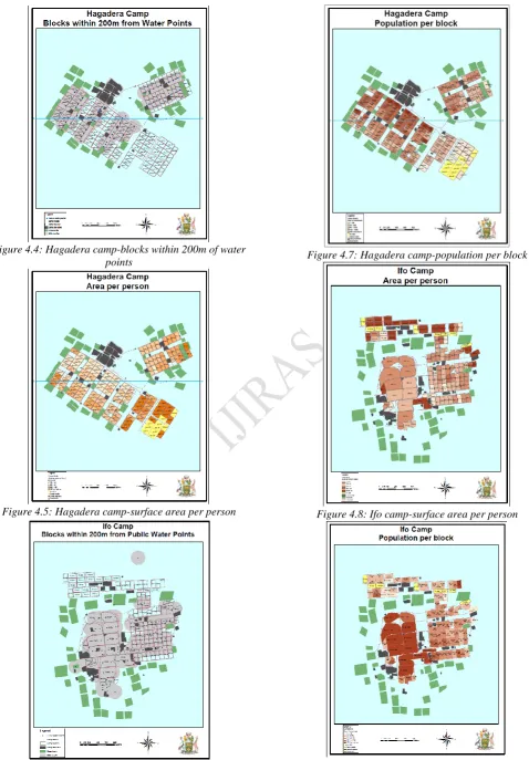
Page 359 www.ijiras.com | Email: contact@ijiras.com Figure 4.4: Hagadera camp-blocks within 200m of water
points
Figure 4.5: Hagadera camp-surface area per person
Figure 4.6: Ifo camp-blocks within 200m of water points
Figure 4.7: Hagadera camp-population per block
Figure 4.8: Ifo camp-surface area per person
Page 360 www.ijiras.com | Email: contact@ijiras.com V. ANALYSIS OF RESULTS
The refugee population data used in this project was an extract from the ProGres database as of 12th May 2009. The spatial database had last been updated in 2007. The analysis and maps produced were based on these two datasets.
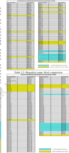
The ProGres and GIS databases were compared and it was revealed that there were blocks that existed in the ProGres database but were missing in the GIS database and vice versa. Dagahaley camp had fifteen blocks in proGres but missing in the GIS database and twenty blocks in the GIS database but missing in ProGres. Hagadera camp had thirteen blocks in proGres but missing in the GIS database and ten blocks in the GIS database but missing in ProGres while Ifo camp had eleven blocks in proGres but missing in the GIS database and eight blocks in the GIS database but missing in ProGres.
An overlay of the block Keyhole Markup Language files over Google Earth imagery revealed that indeed some blocks that were missing in the ProGres database existed. A field visit also revealed that some blocks that were in the GIS database do not actually exist on the ground.
A total refugee population of two hundred and seventy three thousand, eight hundred and fifty eight of whom two thousand four hundred and fifty one did not belong to any block had been registered as at 12th May 2009. Two maps were produced to indicate the performance of the refugee camps in relation to standard core indicator 1 and 2 regarding surface area per person and number of people per water tap respectively.
ProGres database GIS database ProGres database GIS database
DAG A-0 DAG A-0 DAG E-0 DAG E-0
DAG A-1 DAG A-1 DAG E-1 DAG E-1
DAG A-2 DAG A-2 DAG E-2
DAG A-3 DAG A-3 DAG E-3 DAG E-3
DAG A-4 DAG A-4 DAG E-4 DAG E-4
DAG A-5 DAG A-5 DAG E-5 DAG E-5
DAG A-6 DAG A-6 DAG E-6 DAG E-6
DAG A-7 DAG A-7 DAG E-7 DAG E-7
DAG A-8 DAG A-8 DAG E-8 DAG E-8
DAG A-9 DAG A-9 DAG E-9 DAG E-9
DAG A-10 DAG A-10 DAG E-10 DAG E-10
DAG A-11 DAG A-11 DAG E-A DAG E-A
DAG A-a DAG E-B DAG E-B
DAG A-b DAG E-C
DAG A-c DAG F-0 DAG F-0
DAG B-0 DAG B-0 DAG F-1
DAG B-1 DAG B-1 DAG F-2 DAG F-2
DAG B-2 DAG B-2 DAG F-3 DAG F-3
DAG B-3 DAG B-3 DAG F-4 DAG F-4
DAG B-4 DAG B-4 DAG F-5 DAG F-5
DAG B-5 DAG B-5 DAG F-6 DAG F-6
DAG B-6 DAG B-6 DAG F-7 DAG F-7
DAG B-7 DAG B-7 DAG F-8 DAG F-8
DAG B-8 DAG B-8 DAG F-9 DAG F-9
DAG B-9 DAG B-9 DAG F-10 DAG F-10
DAG B-10 DAG F-A DAG F-A
DAG B-a DAG F-B DAG F-B
DAG B-b DAG F-C
DAG B-c DAG G-1
DAG C-0 DAG C-0 DAG G-2
DAG C-1 DAG C-1 DAG G-3
DAG C-2 DAG C-2 DAG G-4
DAG C-3 DAG C-3 DAG G-5
DAG C-4 DAG C-4 DAG G-6
DAG C-5 DAG C-5 DAG G-7
DAG C-6 DAG C-6 DAG G-8
DAG C-7 DAG C-7 DAG G-9
DAG C-8 DAG C-8 DAG G-10
DAG C-9 DAG C-9 DAG H-1
DAG C-10 DAG C-10 DAG H-2
DAG D-0 DAG D-0 DAG H-3
DAG D-1 DAG D-1 DAG H-4
DAG D-2 DAG D-2 DAG H-5
DAG D-3 DAG D-3 DAG N-AA
DAG D-4 DAG D-4 DAG N-AB
DAG D-5 DAG D-5 DAG N-AC
DAG D-6 DAG D-6 DAG N-BA
DAG D-7 DAG D-7 DAG N-BB
DAG D-8 DAG D-8 DAG N-BC
DAG D-9 DAG D-9 DAG N-D0
DAG D-10 DAG D-10 DAG N-DA
DAG D-a DAG N-DB
DAG D-b DAG N-DC
DAG D-c DAG N-EA
DAG N-EB
DAGAHALEY-BLOCK COMPARISON BETWEEN PROGRES AND GIS DATABASES. 12/05/2009
Blocks not mapped but exist in proGres Blocks mapped but not in proGres
Table 5.1: Dagahaley camp- block comparison
ProGres database GIS database ProGres database GIS database
HAG A-1 HAG A-1 HAG I-1 HAG I-1
HAG A-2 HAG A-2 HAG I-2 HAG I-2
HAG A-3 HAG A-3 HAG I-3 HAG I-3
HAG A-4 HAG A-4 HAG I-4 HAG I-4
HAG A-5 HAG A-5 HAG I-5 HAG I-5
HAG A-7 HAG A-7 HAG I-6
HAG A-8 HAG A-8 HAG I-7 HAG I-7
HAG A-9 HAG A-9 HAG I-8 HAG I-8
HAG A-10 HAG A-10 HAG I-9 HAG I-9
HAG B-1 HAG B-1 HAG I-10 HAG I-10
HAG B-2 HAG B-2 HAG I-11
HAG B-3 HAG B-3 HAG J-1 HAG J-1
HAG B-4 HAG B-4 HAG J-2 HAG J-2
HAG B-5 HAG B-5 HAG J-3 HAG J-3
HAG B-6 HAG J-4 HAG J-4
HAG B-7 HAG B-7 HAG J-5 HAG J-5
HAG B-8 HAG B-8 HAG J-7 HAG J-7
HAG B-9 HAG B-9 HAG J-8 HAG J-8
HAG B-10 HAG B-10 HAG J-9 HAG J-9
HAG C-1 HAG C-1 HAG J-10 HAG J-10
HAG C-2 HAG C-2 HAG K-1 HAG K-1
HAG C-3 HAG C-3 HAG K-3 HAG K-3
HAG C-4 HAG C-4 HAG K-4 HAG K-4
HAG C-5 HAG C-5 HAG K-5 HAG K-5
HAG C-7 HAG C-7 HAG K-7 HAG K-7
HAG C-8 HAG C-8 HAG K-8 HAG K-8
HAG C-9 HAG C-9 HAG K-9 HAG K-9
HAG C-10 HAG C-10 HAG K-10 HAG K-10
HAG D-1 HAG D-1 HAG L-1 HAG L-1
HAG D-2 HAG D-2 HAG L-2 HAG L-2
HAG D-3 HAG D-3 HAG L-3 HAG L-3
HAG D-4 HAG D-4 HAG L-4 HAG L-4
HAG D-5 HAG D-5 HAG L-5 HAG L-5
HAG D-6 HAG L-6
HAG D-7 HAG D-7 HAG L-7 HAG L-7
HAG D-8 HAG D-8 HAG L-8 HAG L-8
HAG D-9 HAG D-9 HAG L-9 HAG L-9
HAG D-10 HAG D-10 HAG L-10 HAG L-10
HAG E-1 HAG E-1 HAG M-1 HAG M-1
HAG E-2 HAG E-2 HAG M-2 HAG M-2
HAG E-3 HAG E-3 HAG M-3 HAG M-3
HAG E-4 HAG E-4 HAG M-4 HAG M-4
HAG E-5 HAG E-5 HAG M-5 HAG M-5
HAG E-6 HAG M-6 HAG M-6
HAG E-7 HAG E-7 HAG M-7
HAG E-8 HAG E-8 HAG M-8
HAG E-9 HAG E-9 HAG M-9
HAG E-10 HAG E-10 HAG M-10
HAG F-1 HAG F-1 HAG N-1 HAG N-1
HAG F-2 HAG F-2 HAG N-2 HAG N-2
HAG F-3 HAG F-3 HAG N-3 HAG N-3
HAG F-4 HAG F-4 HAG N-4 HAG N-4
HAG F-5 HAG F-5 HAG N-5 HAG N-5
HAG F-7 HAG F-7 HAG N-6 HAG N-6
HAG F-8 HAG F-8 HAG N-7 HAG N-7
HAG F-9 HAG F-9 HAG N-8
HAG F-10 HAG F-10 HAG N-9
HAG G-1 HAG G-1 HAG N-10 HAG N-10
HAG G-2 HAG G-2 HAG O-1 HAG O-1
HAG G-3 HAG G-3 HAG O-2
HAG G-4 HAG G-4 HAG O-3
HAG G-5 HAG G-5 HAG O-4
HAG G-6 HAG O-5
HAG G-7 HAG G-7 HAG O-6
HAG G-8 HAG G-8 HAG O-7
HAG G-9 HAG G-9 HAG O-8
HAG G-10 HAG G-10 HAG O-9
HAG H-1 HAG H-1 HAG O-10 HAG O-10
HAG H-2 HAG H-2 HAG S-1
HAG H-3 HAG H-3
HAG H-4 HAG H-4
HAG H-5 HAG H-5
HAG H-7 HAG H-7
HAG H-8 HAG H-8
HAG H-9 HAG H-9
HAG H-10 HAG H-10
HAG H-11
HAGADERA-BLOCK COMPARISON BETWEEN PROGRES AND GIS DATABASES. 12/05/2009
Blocks mapped but not in proGres Blocks not mapped but exist in proGres
Table 5.2: Hagadera camp- block comparison
ProGres database GIS database ProGres database GIS database
IFO A-1 IFO A-1 IFO D-1 IFO D-1
IFO A-2 IFO A-2 IFO D-2 IFO D-2
IFO A-3 IFO A-3 IFO D-3 IFO D-3
IFO A-4 IFO A-4 IFO D-4 IFO D-4
IFO A-5 IFO A-5 IFO D-5 IFO D-5
IFO A-6 IFO A-6 IFO D-6 IFO D-6
IFO A-7 IFO D-7
IFO A-8 IFO D-8
IFO A-9 IFO D-9
IFO A-10 IFO E-1 IFO E-1
IFO A-11 IFO E-2 IFO E-2
IFO A-12 IFO F-1 IFO F-1
IFO A-13 IFO A-13 IFO F-2 IFO F-2
IFO B-1 IFO B-1 IFO F-3 IFO F-3
IFO B-2 IFO B-2 IFO F-4
IFO B-3 IFO B-3 IFO N-1 IFO N-1
IFO B-4 IFO B-4 IFO N-2 IFO N-2
IFO B-5 IFO B-5 IFO N-3 IFO N-3
IFO B-6 IFO B-6 IFO N-4 IFO N-4
IFO B-7 IFO B-7 IFO N-5 IFO N-5
IFO B-8 IFO B-8 IFO N-6 IFO N-6
IFO B-9 IFO B-9 IFO N-7 IFO N-7
IFO B-10 IFO B-10 IFO N-8 IFO N-8
IFO B-11 IFO B-11 IFO N-9 IFO N-9
IFO B-12 IFO B-12 IFO N-10 IFO N-10
IFO B-13 IFO B-13 IFO N-11 IFO N-11
IFO B-14 IFO B-14 IFO N-12 IFO N-12
IFO B-15 IFO B-15 IFO N-13 IFO N-13
IFO B-16 IFO B-16 IFO N-14 IFO N-14
IFO B-17 IFO B-17 IFO N-15 IFO N-15
IFO B-18 IFO B-18 IFO N-16 IFO N-16
IFO B-19 IFO B-19 IFO N-17 IFO N-17
IFO B-20 IFO B-20 IFO N-18 IFO N-18
IFO B-21 IFO B-21 IFO N-19 IFO N-19
IFO B-22 IFO B-22 IFO N-20 IFO N-20
IFO B-23 IFO B-23 IFO N-21 IFO N-21
IFO B-24 IFO N-22 IFO N-22
IFO C-1 IFO C-1 IFO N-23 IFO N-23
IFO C-2 IFO C-2 IFO N-24 IFO N-24
IFO C-3 IFO C-3 IFO N-25
IFO C-4 IFO C-4 IFO N-26
IFO C-5 IFO C-5 IFO N-26
IFO C-6 IFO C-6 IFO N-28
IFO C-7 IFO C-7 IFO N-29
IFO C-8 IFO C-8 IFO N-30
IFO C-9 IFO C-9 IFO N-31
IFO C-10 IFO C-10 IFO S-1 IFO S-1
IFO C-11 IFO C-11 IFO S-2 IFO S-2
IFO C-12 IFO C-12 IFO S-3 IFO S-3
IFO C-13 IFO C-13 IFO T-0
IFO C-14 IFO C-14
IFO C-15 IFO C-15
IFO C-16 IFO C-16
IFO C-17 IFO C-17
IFO C-18 IFO C-18
IFO C-19 IFO C-19
IFO C-20 IFO C-20
IFO C-21 IFO C-21
IFO C-22 IFO C-22
IFO C-23 IFO C-23
IFO C-24 IFO C-24
IFO C-25 IFO C-25
IFO C-26 IFO C-26
IFO C-27 IFO C-27
IFO-BLOCK COMPARISON BETWEEN PROGRES AND GIS DATABASES. 12/05/2009
Blocks mapped but not in proGres Blocks not mapped but exist in proGres
Table 5.3: Ifo camp- block comparison
VI. CONCLUSIONS AND RECOMMENDATIONS CONCLUSIONS
Page 361 www.ijiras.com | Email: contact@ijiras.com price ranges from zero to USD 400 a year, easy to learn and
imitates most of the conventional GIS software functionalities. This project had the objective of extending the capability of the existing UNHCR’s GIS system based on GE to enable refugee camp managers use the technology in their daily management activities, allowing for updating of the data and sharing with interested partners.
Camp administrative boundary layers, facilities, roads, water points, water pipes and green belts for the three camps were converted to GE’s KML so as to form a basis in which the camp managers will use for updating purposes. Thematic maps and standard and indicator maps were also produced and converted to Google Earth’s for visualization purposes and to show how the camps are performing with regard to the set standards. Although the refugee population data was up to date (12th May 2009), the spatial data used by the GIS section was last updated in 2007.
It is envisaged that with the KML files for the three camps in place and with close collaboration among the camp managers, registration officers and GIS experts, GE will be useful to keep the two databases, ProGres and GIS synchronized hence saving on time and financial resources. RECOMMENDATIONS
The following recommendations were as a result of the study carried out in this project. They are meant to lead to, based on Google Earth, a user friendly GIS system used by refugee camp managers, GIS experts and other beneficiaries. Sensitization of staff entrusted with camp management
and registration of refugees on the importance of maps and having them kept up to date.
Carrying out training on the use of Google Earth and other Google mapping products. This should cover Global Positioning System (GPS) data integration in Google Earth and data update using Google Earth imagery. Enhancing collaboration among camp managers, refugee
registration officers and GIS specialists.
Development of a camp mapping manual based on Google Earth for consistency across all camps.
REFERENCES
[1] Burrough, P.A. and McDonnell, R.A. (2000). Principles of Geographic Information Systems, Oxford: Oxford University Press.
[2] Google Earth Basics. (2009). [Blog] Google Earth Blog. Available at: http://www.gearthblog.com/basics.html [accessed 18/03/2009]
[3] Google Earth Imagery. (2009). [Blog] Google Earth Blog. Available at: http://www.gearthblog.com/blog/archives/ 2009/03/about_google_earth_imagery_1.html [accessed 18/03/2009]
[4] Google Earth training for UNHCR. (2008). [ebook] Google. Available at: http://earth.outreach.googlepages. com/UNHCR-training-workbook.pdf [accesed 15/05/2009]
[5] Google Earth User Guide. (2007). [ebook] Google. Available at: http://earth.google.com/userguide/v4/google _earth_user_guide.pdf [accessed 18/03/2009]
[6] Longley P.A., Goodchild M.F., Maguire D.J. & Rhind D.W. (2005). Geographic Information Systems and Science, John Wiley & Sons Ltd.
[7] Mapping in support to Camp Coordination and Management. (2006(c)). UNHCR, Geneva.
[8] Okusimba G.O. (n.d.). Application of Google Earth in refugee camp management. Case Study: Daadab Refugee Camps. M.Sc. Thesis, University of Nairobi.
[9] Practical guide to the systematic use of Standards & Indicators in UNHCR operations. (2006(b)). UNHCR, Geneva.
[10]Refugee Annual Statistical Report. (2008). UNHCR, Nairobi.
[11]Rolf A., Knippers R.A., Ellis Y.S.M.C., Kraak M., Weir M.J.C., Georgiadou Y., Radwan M.M., Westen C.J., Kainz W. and Sides E.J. (2001). Principles of Geographic Information Systems, ITC: Enschede.
[12]Step-by-Step Guide to Mapping a Refugee Camp. (2006(a)). UNHCR, Nairobi.
[13]The Camp Management Toolkit. (2008). [ebook] Norwegian Refugee Council. Available at: http://www.nrc.no/camp [accessed 18/03/2009]