THE LURfN VALLEY, PERU, A.D. 1000-1532
A thests presented for the degree
of
Doctor of Philosophy
May, 1983
Patricia Jane Feltham Institute of Archaeology
ABSTRACT
This thesis discusses the post-Middle Horizon archaeology of one of the smaller central coast valleys of Peru. It focuses on a zone between 400 and 1000 metres above sea level and analyses data collected over several field seasons. There are two appendices dealing with ceramic analysi8 and excavations.
An introduction defines the problems raised by previous work and discus8es field procedures. There is a full treatment of the
environment in order to show the potential self-sufficiency of the zone and its importance as a coca-growing area. Over 100 sites are described and dated to one or more periods, from the Early Horizon to the Colonial Period, on the basis of the pottery found in surface collections and excavations. Reasons are given for the shift in 8ettlement]ocation between early and late periods. There follows a treatment of the late architecture, which is divided into three types:- domestic, ritual and community. It is shown that the
TABLE OF CONTENTS
Page
List of Tables. 6
List of Figures. 8
List of Maps, Plans and Charts. 10
PREFACE 13
CHAPTERS I. II. III. IV. V. VI. VII.
Introduction. The Setting.
The Dating of the North Bank Sites. The Dating of the South Bank Sites. The Architecture of the Late Periods. Settlement and Ethnohistory.
Conclusions.
16 39 70 148 234 350 380 APPENDICES
I. The Ceramic Description 393
Brown Ware 421
Dark Brown Ware 462
Orange Ware 474
The Cuzco Style 603
Black Ware 669
TABLE OF CONTENTS (cont.)
APPENDICES (cont.) Page
II. The Excavations
The Rimac Valley 704
Pachacamac 710
The Lurin Valley 744
Panquilma 744
Avi hay 760
General Conclusions 817
ILLUSTRATIONS AND CAPTIONS 825
NOTES ON THE MAPS AND CHARTS 1078
1. 2. 3. 4. 5. 6. 7. 8. 9. 10. 11. 12. 13. 14. 15. 16. 17. 18. 19. 20. 21. 22. 23. 24. 25. 26. 27. 28.
LIST OF TABLES
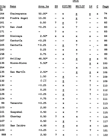
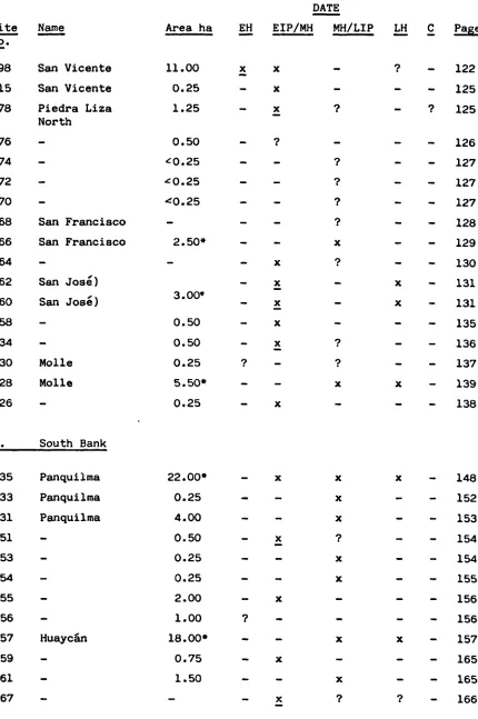
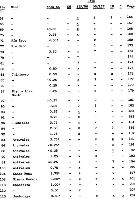
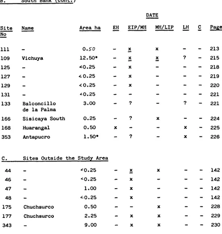
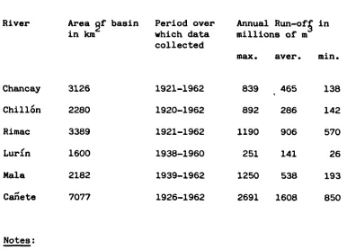
A List of Sites in the Study Area: their Name, Date, Area and Page Reference. The Volume of Water discharged by Central Coast Rivers.
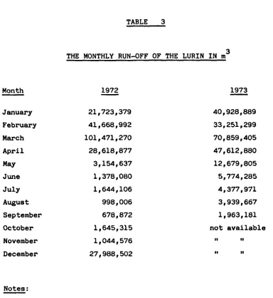
The Total Run-off of the Lur(n by Month in Cubic Metres.
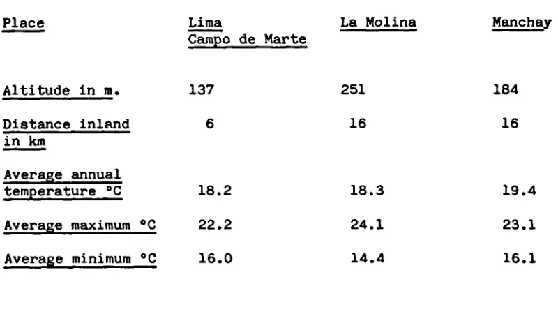
Temperatures at Selected Central Coast Stations.
Precipitation at Selected Stations in the Department of Lima.
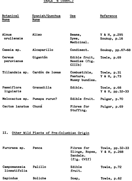
The Flora of the Lurn Valley. The Fauna of the Lurfn Valley.
Types of Architecture at Major LIP and LH sites.
Freestanding Wall Heights and Widths.
Measurements for Single and Multi-chambered Tombs.
Me&surements for Entrances. Measurements for Doors.
Measurements for Doors with Barholds.
Measurements for Sealed Doors and Entrances. Measureuients for Niches.
Measurements for Windows.
Measurements for Communicating Holes. Measurements for Projecting Stones. Measurements for Projecting Bones. Measurements for Projecting Branches. Measurements for Stairs.
Measurements for Projecting Stone Steps. Measurements for Wide Benches.
Measurements for Narrow Benches. Measurements for Eamps.
Measurements for Wall Decoration. Measurements for Roofing Material. Measurements for Vertical Posts.
29. 30. 31. 32. 33. 34. 35. 36. 37. 38. 39. 40. 41. 42. 43. 44.
LIST OF TABLES (cont.)
Page 309 312 314 315 329 360 362 396 409 612 737 754 757 806 809 813 Measurements for Pits.
Measurements for Above-ground Compartments. Measurements for Subterranean Compartments. Association of Compartments with Rooms and Bones.
Agricultural Terraces and Ditches.
Ratio of Taxpayers to the Total Population. Maize Yields and Consumption Figures for Selected Areas.
Sherd Totals by Year and Method of Collection. Percentage of Different Wares per Site.
Size Variation among Cuzco Polychrome Vessels. List of Small Finds from Strong, W..l1ey and Corbett's Excavation at Pachacamac.
Preliminary Identification of Faunal Remains from Excavations at Panquilma and Avillay. Identification of Vegetal Material from Panquilma.
Identification of Vegetal Material from Avillay. Summary of Small Finds other than Potsherds from all Excavations.
Page 828 858 866 868 937 949 975 985 991 999 1003 1005 1009 1013 1015 1019 1025 1027 1029 1031 1033 1035 1037 1039 1041 LIST OF FIGURES
'-XIV XV-XVIII XIX XX-L LI-LVI LVII-LXIX LXX-LXXIV LXXV-LXXVII LXXVIII-LXXXI LXXXII-LXXXIII LXXXIV LXXXV-LXXXVI LXXXVI I-LXXXVIII LXXIX XC-XCI XC II-XC IV XCV XCVI XCVII XCVIII XCIX C CI CII CIII
Brown Ware Vessels and Rims from Forms I-XIII.
Dark Brown Ware Vessels and Rims from Forms I-IV.
Miscellaneous Brown Ware Sherds. Orange Ware Vessels and Rims from Forms I-XVI.
Orange Ware Decorated Body Sherds and Miscellaneous Sherds.
Cuzco Style: Aryballoid Jars. Cuzco Style: Two-handled Dishes. Cuzco Style: Plates.
Cuzco Style: Pedestal Base 011as. Cuzco Style: Other Jars.
Cuzco Style: Bowls.
Cuzco Style: Miscellaneous. Black Ware: Elaborate Jars. Black Ware: Other Jars.
Black Ware: Two-handled Dishes. Black Ware: Bowls, 011as and Plates. Black Ware: Miniature Bowls and Miscellaneous Sherds.
Colonial, Modern and Early Horizon Vessels and Sherds.
Early Intermediate Period Vessels and Rims.
Rims from Huarochir: Various Wares. Other Ceramic Artefacts.
Ceramic and Stone Artefacts. Stone Artefacts.
1043 1045 1047 1049 1053 1054 1055 1056 1057 1058 1059 1060 1061 1062 1063 1064 1065 1068 1069 1071 1072 1073 1074 1075 1076 1077 LIST OF FIGURES (cont.)
Page CIV CV CVI CVII-CVIII CIX CX CXI CXII CXIII CXIV CXV CXVI CXVII CXVIII CXIX CXX CXXI-CXXIII CXXIV CXXV-CXXVI CXXVII CXXVIII CXXIX CXXX CXXXI CXXXII CXXXIII
Wood and Metal Artefacts.
Metal, Shell and Glass Artefacts. Leather, Textile and Fibre Artefacts. Wall Decoration.
Profile and Cr088-section of the Lurin Valley.
PV48-1, Pachacamac, Test Pit A, Plan. Panquilma Test Pit 1, Section of the Southwest Face.
Panquilma Test Pit 1, Section of the Northeast Face.
Panquilma Test Pit 1, Section of the Southeast Face.
Panquilma Test Pit 1, Plan after clearing Layer 8.
Avillay Test Pits 1 and 2, Sections. Avillay Test Pits 3 and 4, Sections. Avillay Test Pit 5, Sections.
Avillay Test Pit 6, Plan and Section. Avillay Test Pit 7, Section.
Avillay Test Pit 8, Plan. Avillay Test Pit 8, Sections.
Avillay Test Pit 9, Plan Avillay Test Pit 9, Sections.
Avillay Te8t Pits 9 and 10, Sections. Avillay Test Pit 11, Plan.
Avillay Test Pit 11, Sections. Avillay Compartment 3, Section.
LIST OF MAPS
I. GENERAL MAPS (G.M.)
1. The Central CoaBt of Peru and the Adjacent Highlands. 2. The Lurin Valley, showing important sites during the Late
Horizon and communications with neighbouring valleys.
3. The Study Area, showing the sites located by the 1966 survey team.
4. The Study Area, showing the extent of occupation during the Early Horizon.
5. The Study Area, showing the extent of occupation during the Early Intermediate Period and the early Middle Horizon. 6. The Study Area, showing the extent of occupation during the
late Middle Horizon and the Late Intermediate Period.
7. The Study Area, showing the extent of occupation during the Late Horizon.
8. The Study Area, showing the extent of occupation during the Colonial Period.
9. The Study Area, showing the major modern irrigation ditches and the ancient ones.
II. SITE MAPS (S.M.)
A. North Bank
1. The Chaimayanca quebrada. 2. Quebradas near Sisicaya. 3. The Cantur^a quebrada.
4. The Avillay and Nieve-Nieve quebradas. 5. The San Martin quebrada.
6. The Yanacoto andGuayabalquebradas. 7. Chontay.
8. The San Isidro quebrada. 9. The San Vicente quebrada. 10. The San Francisco quebrada. 11. San José.
II. SITE MAPS (S.M.) (continued)
B. South Bank 13. Panquilma.
14. The Huaycn quebrada. 15. The Rio Seco quebrada. 16. Cerro Colorado.
17. Pichicato.
18. The Antivales quebrada.
19. South Chontay and Sierra Morena. 20. Trie Anchucaya quebrada.
21. Vichuya.
22. Balconcillo de la Palma.
23. The Huarangal and Antapucro quebradas. 24. Chuchsurco.
III. SITE PLANS (S.P.)
1. Chaimayanca - site 164. 2. Sisicaya - site 169.
Avillay - site 137. 4. Nieve-Nieve - site 136.
5. San Martin - site 135. 6. San Francisco - site 66.
San José terraces - sites 60 and 62. 8. Molle - site 28.
9. Panquilma - site 35. 10. Huaycán - site 57. 11, Rio Seco - site 71. 12A)
12B) Antivales-Lindero - site 84. 12C)
III. SITE PLANS (S.P.) (continued)
15. Sierra Morena - site 108. 16. Chacralta - site 110. 17. Anchucaya - site 113. 18A)
185) Vichuya - site 109. 18C)
19. Antapucro - site 353. 20. Pachacamac - site 1.
IV. CHARTS
I. Surface Collections from Late Horizon Sites Tabulated by Ware, Form, Site and Year of Collection.
II. Surface Collections from Late Intermediate Period and Other Sites Tabulated as above. Sherds from Excavations at Pachacamac and Panquilma Tabulated by Ware, Form and Excavation Layer. III. Sherds from Excavations at Avillay Tabulated by Ware, Form and
Excavation Layer.
PREFACE
This study owes a good deal to the help and advice given to me over a number of years by people in three different countries. First and foremost, my debt to the Peruvian people is enormous because they allowed me to work in the Lurin Valley. One particularly involved in my work was Dra Isabel Flores Espinoza of the Instituto Nacional de Cultura, to whom I am very grateful for her assistance in setting up the project and her advice on its
administration. Dra MarIa Rostworowski de Diez Canseco, Directora del Museo Nacionai. de Historia, gave me insight into the ethnohistory of the Lurin and made available unpublished documents. My heartfelt gratitude also goes to the four Peruvian students, Carlos Elera, Carlos Eacobar McEvoy, Natalia Lara Vargas and Lourdes Barrartes Sanchez, who accompanied me into the field and shouldered some onerous burdens. Dr Alberta Bueno Mendoza, archaeologist in charge of the Lurin, has given helpful information and allowed me to work at Pachacamac and to store collections at Puente de Lurin. I am also grateful to Dr Arturo Jiménez Borja and Ponciano Paredes Botoni for
countless favours, and to Eulogio Gómez, whose knowledge of
Pachacaxnac is superior to that of any archaeologist. The fieldwork would never have been accomplished without the loyal support of Francisco Asencios Chac6n arid Francisco Flores Vargas, who undertook so many tasks cheerfully arid assisted with the sorting and identification of the fauna and flora. In the valley mention must be made of the
of Sisicaya; and of Fidel Aquise and Canoe de la Cruz of Huaycán. In Chontay I am indebted to Dr Augusto Bedoya, owner of Sierra Morena, for letting me live at the farm, and to his family and the Benigno family for their hospitality. At Santo Domingo de los 011eros there are many villagers who willingly answered my questions and gave us food and shelter, in particular, Tomás Reyes, Julio Obispo, Canoe Perez Obispo and his mother, Hilaria Javier.
In the United States I should like to thank Dr Shirley Gorenstein and Dr Edward Lanning, both formerly of Columbia University, who first stimulated my interest in Peru and gave me every help and encouragement to go there; also Dr Thomas Patterson, now of Temple University, who supervised the project in its initial stages, loaned a jeep and
equipment in the field, and generously provided access to notes and collections. In Philadelphia Dr A.V.N. Sarma of Temple University and his family have given me much assistance with lodging and laboratory facilities, as has Muriel Kirkpatrick, Laboratory Coordinator at Temple. Miss Claudia Medoff, Keeper of American Section Collections at the Museum of the University of Pennsylvania, kindly allowed me to examine the Uhle material. In New York I greatly appreciate the assistance of the late Dr Junius Bird, Curator Emeritus of the Museum of Natural History, and Dr Craig Morris, Assistant Curator, who made available the Strong and Corbett collections and notes on Pachacamac and provided me with additional information. Barbara Conklin, of the same museum, remembered the existence of the Baridelier collections and found the relevant catalogue. Bob Sonin provided valuable information on ceramics. I am also grateful to Drs Gordon and Helen Pollard of the State University of New York at Plattsburgh for information and
Last but not least, in England I should like to thank Dr Ann Kendall, Director of the Cusichaca Projec for many helpful
discussions; Dr E.J. Cobbing of The Institute of Geological Sciences for information on the geology of the valley and identification of rocks and minerals; Dr Nigel Seeley of the Institute of Archaeology for help with the ceramic analysis; Dr Warwick Bray for his
encouragement and assistance with the preparation of this thesis; and Judith Harris for typing the manuscript.
CHAPTER ONE
INTRODUCTION
The Lurin valley presents a paradox. On the one hand, it i among the smaller central coast valleys with a second class river whose average run-off does not reach the minimum of the Chill6n's, thereby restricting the agricultural potential of the area. Yet on the other hand, Pachacainac, one of the most important coastal settlements of ancient Peru, is situated at its mouth and this site's existence undoubtedly influenced the way the Incas treated the valley after conquering it in the 15th century. It was to explain the rise and possible decline of Pachacamac in terms of the LurIn hinterland that the LurIn Valley Project was initiated in 1966 by Dr Thomas Patterson, then of Harvard University. At that time little
archaeological work had been carried out in the actual valley, al-though Pachacamac had received a great deal of attention. 1 Con-sequently, it was hoped that much new information would be obtained.
The immediate aims of the project were to survey all of the river valley that might properly be considered "coast", as opposed to
pre-Coluznbian Andean cultures and it was hypothesised that Pachacamac was a city at some point in its history, probably during the Middle Horizon, and that it later reverted to a ceremonial centre during subsequent periods (Rowe 1963, p.12, 15, 17; Lanning 1967, p.135). It was hoped that the findings of the project on settlement within the valley would resolve this problem and determine how much highland influence there was on the coast, particularly during the Early and Middle Horizons.
The methods chosen were intensive archaeological survey and a limited amount of excavation. A small team of students from Harvard, Berkeley and Columbia universities accompanied Dr Patterson to Peru in the summer months of 1966. During their three months in the field they surveyed the quebrada fans and valley sides and from the base of the slope to the ridge top, as well as part of the valley floor, if an ancient mound was visible. 350 sites were located, a good propor-tion of which are scatters of sherda or worked stone situated behind the dune that flanks the long beach known as the "Playa de Conchn" to the north of the Pachacamac ruins. 2 This area is known as the Tablada de Lurin and has received recent attention from archaeologists, but is
3
beyond the scope of this study. Most of the other sites are at the edge of the cultivated area. From the site notes it would seem that the valley floor was not systematically surveyed. Certainly it would be difficult to find ancient cultural remains there, because it has been intensively cultivated from Cieneguilla to the shore. The team also carried out a small excavation in the environs of Pachacamac. This is discussed in Appendix II.
At each site a sample of the portable cultural material was
the shore, yielded only worked stone. There is also a substantial number of textiles. 4 All these collections were shipped to the United States arid are currently stored at Temple University in Philadelphia.
The surveying and collecting methods have some drawbacks. Those that concern ceramics are discussed in Appendix I. Others are as
follows:- firstly, the pressures of field life resulted in the survey's being carried out in a haphazard fashion. One day the team would be upvalley and the next downvalley. Since the sites were numbered in
the order in which they were found, one number may be near Antioqula and the next in sequence near Pachacamac. This meant that it was harder for the team members to obtain a clear picture of any one zone, and it was not easy to make comparisons between sites as the work proceeded. Secondly, it was assumed rather than demonstrated that
the valley floor contained no sites, but it is possible that some have been ploughed under because of the extension of the cultivated area, particularly downvalley from Manchay. This point needs to be checked in the future. Thirdly, there was no consistent definition of what
constitutes a site. Vague definitions can be hazardous if' comparisons are made between the number of sites per time period. 5 Fourthly,
L even in my own small study area not all sites with architecture were noted on the first survey. Site 353 was missed completely, as was another site on the hill top above sites 26 and 28, and also a large portion of 113. Therefore, it is likely that sites have been missed in the larger area downvalley. Fifthly, since no random method of
To date there have been some published results for the Preceramic Period, the Early Horizon and the Early Intermediate Period. More are planned for the near future. 7 During 1968 both Harry Scheele and Timothy Earle worked in the study area chosen by me, the former concentrating on the Early Horizon in the valley, and the latter on the Early Intermediate Period from Molle to Palma. Neither study is complete, for I believe that there are more Early Horizon sites in the valley than Scheele allowed for, as I have indicated on map G.M. 4. It is likely that some of the pottery thought to belong to the Early Intermediate Period belongs as well in the Early Horizon. Excavation for radiocarbon samples should confirm this. 8 Scheele concentrated on local manifestations of U-shaped structures rather than domestic habitation, which is the aspect that requires further work. Earle's study suffers from his not taking into account mixed-period or
long-I
occupation sites, so that many sites at which Early Intermediate Period pottery can be identified are not considered, e.g. 137, 169, 159, 164, 35, 160 and 90. Consequently his remarks on settlement and population changes will have to be adjusted. In addition, in his survey of
irrigation ditches, he did not check out the ancient extensions or obtain correct information on the modern ditches, so that much of his published discussion is worthless. 9 Because of the lacunae in the above-mentioned works, it has been necessary to devote a considerable portion of this thesis to dating sites in the study area.
My own task was to investigate the late sites in the Lur^n and 10
not cover all the area originally surveyed, so a study area was chosen for intensive investigation. It lies between the quebradas of Molle and Chaimayanca on the north or right bank, and between the quebradas of Pariquilma and Antapucro on the south or left bank, as maps G.M. 2 and 3 will show. It comprises the valley floor and hill alope from the 400 to the 1000 metre contour line.
This area was chosen for several reasons. In the first place, both Earle and Scheele had worked there and could provide information on the early periods. Secondly, it was a small area, 20 kilometres long and 0.5-1 kilometre wide, so that it could be surveyed intensively by one or two people. A vehicle would have been needed further
downvalley, and upvalley the sites are much higher above the valley floor and take longer to reach on foot. Thirdly, it is difficult for irrigation to expand in this sector, where the river cuts steeply
In archaeological terms my aims were as
follows:-a) to examine the sites that had been tentatively dated as late by Patterson's students.
b) to map the major late sites.
c) to obtain more information on ceramics in order to
differentiate between Late Intermediate Period and Late Horizon pottery.
d) to put in limited excavations in order to ascertain the function of buildings.
e) to survey the land and irrigation ditches in order to cal-culate the amount under cultivation during the late pre-historic periods.
f) to assess the amount of Inca influence in the valley during the Late Horizon.
How far these aims have been achieved can be seen from the conclusions. Certainly the question of the function of structures still requires attention and the ceramic analysis needs the support of radiocarbon dates. It is hoped to tackle these problems in the near future.
The study area was further divided into four sectors in order to facilitate description and analysis. From east to west these are: Sisicaya, Chontay, Piedra Liza and Huaycn, (see maps G.M. 2, 3 and 9). Similar divisions are recognised by the local inhabitants.
discounted from the study since it is part of the Chillaco sector upvalley. It has been included because the study area was defined before the irrigation ditches were surveyed and the relationship between ditches and sectors became apparent. In addition, sites 353, 177 and 175 are unusual and provide interesting comparative material.
The Chontay sector begins at the quebrada of San Martin on the north bank, and the Vichuya hills on the south bank, where ditch XIV begins. This sector is irrigated by ditches IV, V, VI, VII, XIII and XIV. It ends as the valley begins to narrow, just past the quebrada of Antivales on the south bank.
The Piedra Liza sector is the narrowest part of the study area. It is irrigated by short ditches, some of which are recent and therefore unnumbered on map G.M. 9. The ancient ditches are nos. VIII and XII. The latter begins in Chontay, which makes it probable that before the
14 Spanish conquest these three sectors were all part of Sisicaya.
The fourth sector, Huaycn, is the most easily defined because the ditches of San Francisco, no. IX, and Huaycin, no. XI, begin a little after a prominent hummock on the south bank, at a point where the valley is at its narrowest. The sector ends at the modern bridge over the river at Cieneguilla where the Molle ditch, no. X, ends and the river bends to flow southwest.
since been destroyed to make way for a camp for road workers.
Excavations were carried out at both sites 137 and 35. During the 1978 field season plans were made of the major Late Horizon sites and extensive notes were taken on architect'iral features. In addition, the irrigation ditches were surveyed and the ancient ones traced on a map. A discussion on these tasks and a clarification of terminology follow.
1. Mapping
a. Site Plans S.P. Nos. 1 - 20
It was originally proposed to make plans of all sites occupied during the Late Horizon, but lack of time did not allow sites 84 and 96 to be mapped. There is, however, a plan of some structures at site 84, made with atheodolite by Sandra Negro of the Universidad de Ricardo Palma. She has also made plans, all at the scale of 1:100, of certain structures at sites 28, 57, 86, 136 and 137 for Alberto Bueno,the arohaeologist in charge of the Lurin valley. He hopes to publish these in the near future) 5 Each of these plans, however, includes only a portion of the site, so that a good general plan was needed to show the relationships between the major and minor structures and between these and natural or man-made features. I have attempted to do this using a Gurley alidade and plane table to map fifteen late sites. It is true that the size of the plane table necessarily determines the scale of the plan, which is 1:500 for ten of the plans
16
and 1:1000 for four others, but such scales are effective in that
of a quebrada could be mapped by this method, since it was too
difficult and time-consuming to carry the instruments up steep slopes. This does not affect the downvalley plans, where there is little
occupation on the upper slopes, but it has affected the plans of sites 137 and 164, where there is extensive ridge-top occupation. At four sites, where it was too difficult to transport the instruments or there was not time to map the entire site, plans were made of one or two - outstanding structures, using compass, tape and level. Such sites
were 66, 109, 169 and 64. For Pachacamac I have used Strong, Willey and Corbetts plan (Strong and Corbett 1943, fig. 1) with additions of my own. It might be asked why air photos were not used to provide base maps, as had been done elsewhere for Peru) 7 Unfortunately, there is only one poor series of photos from a 1962 flight for the Lurn
valley. Even when these are blown up or used with a stereoscope, they do not reveal the sites clearly. Until a better set can be made, any method of photogrammetry will not give useful results.
b. Site Maps S.M. Nos. 1 - 24
These show the spatial relationships of sites to one another, particularly where there are several in one quebrada or along a hill slope. I decided that the site location map for the study area,
(G.M. 3), gives too little information about sites and have therefore made a series of enlargements of the 1:25,000 map of the study area, made by the Instituto Geográfico Militar (I.G.M.). Where a site plan was made, the site can easily be transferred to these contour maps because readings were taken on identifiable features but, for the early sites and such late sites that I have not been able to map, I have had to rely on estimates from my own survey work and the field notes of the original survey team. Our observations do not always coincide, particularly with regard to area, so that I am confident that the location of these sites is correct, but their area, as shown on the plan, may be wrong.
c. General Maps G.M. Nos. 1 - 9
These show inter- and intra-valley communications, irrigation ditches and general site locations. I have used three sources to make them:- the 1977 I.G.M. maps of the LurIn valley and Huarochirl,
(hojas 25-j and 25-k),which have a scale of 1:100,000; the 1955 I.G.M. maps of the Lima and Mala zones, (hojas 12-a and 12-b), which have a scale of 1:200,000; and the 1.962 air photos, which have the awkward scale of 1:62,500. These last were used by Dr Thomas Patterson to make the original, as yet unpublished, site map of the valley.
have made use of the information on it, supplemented by my own observa-tions. The older of the I.G.M. maps better shows inter-valley
series do not always coincide. In order that my work should correspond with that of A].berto Bueno, I have used the names on the recent map, although I believe the older map to have the
authentic names. 18 It should also be stated that on the Peruvian National Grid System all sites are close to the river between points 307 8663 and 325 8669.
2. Excavations
My own and those of other workers are fully described in Appendix II. In the 1968/9 field season eleven test pits, about 1 by 3 or 2 by 2 metres, were placed in various locations at site 137. Six small compartments were also cleared, and another test pit dug at site 35. At the former site three of the pits (nos. 1, 2 and 3) were placed in terraces in order to ascertain whether these could have been used as dwellings with perishable superstructures. The three terraces were chosen mainly for ease of access with the equipment. Three pits (nos. 4, 5 and 6) were put in the courtyards of the patio group, and one (no. 9) in the courtyard in front of the gabled room, in order to ascertain the function of these spaces. Pit no. 8 was placed inside the gabled room for the same reason, and three others
(nos. 7, 10 and 11) were placed in refuse heaps, as was the one at site 35. It was hoped that the refuse heaps would provide a long sequence of deposition from the Late Intermediate Period to the Late Horizon. In fact the refuse turned out to be looters' backdirt from the post-conquest sacking of tombs and could not be used to provide a ceramic sequence since the sherds were mixed. It is instructive that the pits in rooms and terraces yielded far less material than those dug in the so-called refuse.
field seasons form the basis for the ceramic study in Appendix I. All sherds from excavations were saved with the exception of plain Brown Ware body sherds from site 137. These were sorted, counted and discarded in the field. All the excavation fill was screenei with a ce:Ltimetre square mesh and re-examined after sifting, so that only the smallest seeds and bone fragments would have escaped our notice. All the vegetal material, bone and shell in the screen was saved from the excavation at site 35. At site 137, a representative sample of these categories was saved with the help of Francisco Flores, who was able to identify most of the bone and plants. All this material and the artefacts are stored at the Casa de la Guardianla de las ruinas de Pachacamac in Puente de Lurn. The only exception is the human skeletal material from 137. This was rEp1aced in its respective
pit before backfilling, since there were no adequate transport or storage facilities for it.
3. Survey Work
All Late Horizon sites shown on map G.M. 2 in the study area have been visited by me, as have most Late Intermediate Period sites, with the exception of site 166 and a few on the south bank of
Huaycn. I have also visited some Early Intermediate Period sites, such as 58, 106 and 177, in order to obtain comparative material.
Both banks in the study area have been carefully surveyed for irrigation ditches by me and Peruvian students, so that I do not feel that any ditch has been missed. However the ditches on my map G.M. 9 do not correspond
19
entirely to the list given by Arenas and La Rosa. The main difficulty lies in the area from Chontay to Sisicaya where they list more than I have found. There would be a greater correspondence if it were certain
that the ditches named by them Alto and Bajo were to come from the same intake point, being merely the upper and lower branch of the same ditch. In any casç their ditches are listed in a jumbled fashion and they
give no map of the Sisicaya area. When they refer in their text to Sisicaya, they usually state "sin datos", so that their list must be considered suspect. There are also some very short ditches on map G.M. 9. These appear to have been dug recently and are connected with the Land Reform Act of the late sixties. They have not been given a number.
4. Dating
the Late Intermediate Period, as the ceramic analysis suggests. For the present I have used the absolute dates suggested by Lanning because his are round numbers (Lanning 1967, p.25). Until a series of' radiocarbon dates is obtained, it is impossible to decide which of Rowe's scales to use (Rowe 1967, p.25, table 3). It should be recalled, however, that although in the "Berkeley" scheme the Late Horizon is assumed to begin around 1476, this is the date for the
conquest of the Ica valley by the Incas. Their conquest of the central coast took place a few years earlier, between 1463 and 1471 (Rowe 1967, p.10 and 1946, pp.203-207).
5. Site Nomenclature
Site
No
164
159
161
173
171
169
167
165
160
158
137
136
354
135
134
132
130
128
126
124
99
103
101
105
107
102
100
98B
Name
Chaimayanca
Piedra Angel
San José
81 caya
Canturfa
Canturla
Avi hay
Ni eve-Ni eve
San Martin
Yanacoto
Guayabal
Chontay
San Isidro
30
TABLE 1
A LIST OF SITES IN THE STUDY AREA: THEIR NAME, DATE, AREA AND
PAGE REFERENCE
A.
North Bank
DATE
Area ha
EU EIP/MH MH/LIP LU C Page
50.00*
-
x
x
x
x
74
10.00
-
x
-
-
81
0.50
?
x
?
-
-
82
<0.25
-
x
-
-
83
-
?
x
-
-
-
83
2.50'
x
x
x
x
-
84
'0.25
-
-
x
-
-
86
< 0.25
-
x
- - -
88
0.25
-
x
x
-
-
88
0.75
-
x
?
-
-
89
46.50*
-
x
x
x
x
91
5.50'
-
-
-
x
x 100
-
-
-
x
-
- 105
2.50*
-
-
Xx
x 106
1.50
-
x
-
?
- 109
025
-
x
-
?
- 109
<0.25
-
x
-
- 110
0.25
-
x
-
?
- 112
<0.25
-
x
-
- 113
0.75
-
x
-
-
- 111
<0.25
-
X - - -113
2.00
-
x
-
-
- 115
0.50
-
x
?
-
- 115
0.50
?
X X - -116
0.50
-
x
-
?
- 117
4.00
-
X X X -120
O.25
-
-
-
?
- 121
11.00
0.25
1.25
0 • 50
'0 • 25
0.25
0.25
2.50*
3 • 00'
0.50
0.50
0 • 25
5.50*
0 • 25
x
-
x
-
x
-
?
-
x
-
x
-
x
-
x
-
x
?
--
x
- 122
-
- 125
-
? 125
-
- 126
-
- 127
-
- 127
-
- 127
-
- 128
-
- 129
-
- 130
x
- 131
x
- 131
-
- 135
-
- 136
-
- 137
x
- 139
-
- 138
?
.7x
.7 .7 .7x
22.00*
0 • 25
4 • 00
0.50
0 • 25
0 • 25
2.00
1.00
18.00k
0 • 75
1.50
x
x
x
x
x
x
x
x
- 148
-
- 152
-
- 153
-
- 154
-
- 154
-
- 155
-
- 156
-
- 156
x
- 157
-
- 165
-
- 165
- 166
-
x
-
x
-
x
?
--
x
-
x
31
TABLE 1 (cont.)
A.
North Bank (cont.)
Site Name
No.
98
San Vicente
115
San Vicente
78
Piedra Liza
North
76
-74
72
-70
-68 San Francisco
66 San Francisco
64
-62
San Jose)
60
San Jose)
58
-34
-30
Molle
28
Molle
26
-B.
South Bank
35
Panquilma
33
Panqui].ma
31
Panquilma
51
-53
-54
-55
-56
-57
Huaycán
59
-61
-67
-DATE
TABLE 1 (corit.)
B.
South Bank (cont.)
Site Name
No
63
-65
-69
-75
-71
RIo Seco
77
RIo Seco
73
-79
-81
-80
-83
Chirimoyo
85
-89
-87
Piedra Liza
South
97
-95
-93
-91
-96
Pichicato
94
-92
-84
Antivales
86
Antivales
88
Antivales
90
Antivales
82
Antivales
106
Antivales
104
Santa Rosa
108
Sierra Morena
110
Chacralta
112
113
Anchucaya
DATE
Area ha
EH EIP/MH MH/LIP UI C Page
-
-
x
- 166
-
-
x
-
-
- 167
.0.25
-
x
x
-
- 168
0.25
-
x
-
-
- 168
4.50*
-
-
x
-
- 169
-
-
-
-
- 173
3.50
-
x
-
- 173
-
-
?
-
-
- 174
-
-
?
-
-
- 174
0.50
-
x
-
- 175
0.50
-
-
x
x
- 175
0.25
-
x
-
- 177
0.25
-
x
-
-
- 179
0.25
-
-
x
-
- 179
0.25
-
x
-
-
- 181
0.25
-
?
?
-
- 182
0.25
-
x
x
-
- 183
0.75
-
x
-
-
- 183
0.75
-
x
x
x
- 184
2.00
-
x
?
- 186
1.75
-
x
-
-
- 187
3 • 75*
-
-
x
x
x
1.89
<0.25*
-
-
-
x
- 191
<. 0.25
-
-
-
x
x 192
1.25
-
x
x
-
- 193
0.25
-
x
-
- 194
0.75
-
x
-
-
- 195
1.75
-
-
x
197
9.00*
-
x
x
x
x 201
1.00*
-
-
x
x
- 205
0.50
-
x
-
-
- 207
x
xx
x
x
x
x
#7 9 xx
- -
213
?
- 215
-
- 218
-
- 219
-
- 220
-
- 221
?
- 221
-
- 224
x
- 225
x
- 226
0 •
12. 50*
0.25
<.0.25
0.25
0.25
3.00
o • 25
0 • 50
1.50*
x
x x
x
-
- 142
-
-
142 - -142
-
- 142
-
- 228
-
- 229
-
- 230
-
x- x - x - x
- x - x
33
TABLE 1 (cont.)
B.
South Bank (cont.)
Site Name
No
111
-109
Vichuya
125
-127
-129
-131
-133
Balconcillo
de la Palma
166
Sisicaya South
168
Huarangal
353
Antapucro
DATE
Area ha
EU EIP/MH MH/LIP LH C Page
C.
Sites Outside the Study Area
44 -
'0.25
46
-
0.25
47 -
1.00
48
-
'-0.25
175
Chuchaurco
0.50
177
Chuchsurco
2.25
343
-
9.00
Other Site Names - a Correlation of Bonavia's Site Names
with the 1966 Survey Numbers
1
Pachacamac
12
Pampa de las Flores A
18)
TABLE 1 (cont.)
Other Site Names (cont.)
14 Tambo Inga
16 Quebrada de las Golondrinas 43)
Potrero de Santa Lucfa
Notes to Table 1:
1. Sites are usually named according to the quebrada in which they are situated. A "-" sign means the site has no name. 2. The area is rounded to the nearest 0.25 ha, except -that small
sites of a few hundred square motres are classed as 0.25 ha. A "-" sign means there is not sufficient data to make an
estimate.
3. An asterisk indicates that the whole or part of the site was mapped or measured.
4. The major period of occupation is underlined. Where this is not certain there is no underlining.
5. A question mark means a tentative placing in the period. 6. It should be pointed out that Nieve-Nieve is the name of a
hamlet at the mouth of the Avillay quebrada, as well as the name for site 136.
Chala Chirimoya Cumbi Depósito Huaca
6. Glossary
Certain Spanish and Quechua terms are used in the present study with the meanings given below. Those terms not listed here will be found in the glossary of J. Alden Mason's "Ancient Civilisations of Peru" (1964). Further definition of Spanish terms on the maps is to be found in the section:- "Notes on the Maps and Charts" after the illustrations. Some other terms are explained in the text.
Bocatoma Chacra
Huayco Lücuma
Chile pepper, a variety of capsicum.
The intake point of an irrigation ditch from the river. A field usually bounded by a stone wall or a natural fence of cacti or other plants.
A mass of maize stalks and leaves.
An edible fruit.
A particularly fine cloth woven on a special loom. A storehouse.
The physical manifestation of something sacred to the Indians, such as a stone, spring, mountain, ancient mound, mythical figure or dead ancestor. Such an object possesses a powerful force. The word can be used as a noun or an adjective.
A flash flood during the rainy season. An edible fruit.
Mano A rounded cobble used on top of a large flat stone for grinding.
Pacae An edible fruit.
Pasto A variety of grasses and bushes used as grazing land. Pirca
Pueblo joven Quebrada Quincha
Dry-walling of undressed stone.
Reducci6n A newly created settlement for Indians, designed to concentrate them in one place, as far away as pos8ible from their huacas.
Tumi A kind of knife, see fig. CV-a.
Visita A study and census of a province, carried out by Spanish authorities in order to ascertain the number of Indians, the amount of lands they held and the amount of tribute they paid.
Notes to Chapter One
1. Uhie (1903, preface) lists all those who have written about, or worked at, Pachacamac up to the time of his writing. Any subsequent work is discussed in Appendix II of this thesis. With regard to archaeological work in the valley, Raimondi journeyed up it in 1862 and left notes on the geology, fauna, flora and some ruins (Raimondi 1945 edit., vol. 3). Uhle mentions that Wiener made a rough plan of some ruins near Manchay (Uhie 1903, p.5), and he himself was acquainted with some of the downvalley sites, such as La Centinela (site 199) and Huaycarn (site 57). Villar C6rdova mentions the valley, particularly the petroglyphs at site 177, (Villar Córdova 1935, pp.108, 178-179). Duccio BonavIa is the author of a study on six downvaliey sites (Bonavia 1965) and he mentions other
archaeologists who have worked at, or visited, the Early Horizon site of Mina Perdida, (site 117 on Patterson's map), although none of these has published any comment on their visits, with the exception of Trimborn (1972). The most recent worker in the valley is Alberto Bueno Mendoza, who has cleared part of the main patio group at site 57, sub-dividing it into 3 complexes, and has published a short article on the site (Bueno 1978a).
2. The ruins of Pachacamac, site 1, must be distinguished from the colonial settlement of Pachacamac, (Pachacamac pueblo), which is on the south side of the valley (see map G.M. 2).
3. See Stothert 1980 and her bibliography. The Tablada de Lurrn sites have not been included on map G.M. 2.
4. These have been classified and described by Sandra Dickey, whose paper is in the possession of this author. Most fragments are from late periods.
5. See Appendix I for a further discussion of this point.
6. For example, the original surface collection of site 35 gave no indication of the Early Intermediate Period occupation of the site, although such sherds are on the surface. In all fairness to the team, however, they did manage to obtain generally representative samples, but more by luck than good management.
7. Scheele 1970; Earle 1969 and 1974; Patterson 1971a and l97lb; Patterson and Moseley 1968; MacNeish, Patterson and Browman 1975. All these authors use material from the project.
8. Such a situation has occurred in the Chillón, where Dhl].ehay, in a 1977 article, refers to the site of Huancayo Alto as being occupied from the Early Intermediate Period onwards on the basis of his
9. For example, in his table 5, his section 1 corresponds to my Huayc.n sector where there are three ditches not two, the longest of which is just over 3 kilometres, so that it is impossible for the ditches to have an average length of 9 kilometres. His section 2 corresponds to my Piedra Liza, Chontay and part of Sisicaya, in which there are approximately eleven short ditches, not five as stated in his table (Earle 1974, p.474).
10. In this thesis "late" is defined as post-Middle Horizon and "early" as pre-Middle Horizon.
11. I have, however, mapped two large structures at Pachacainac for comparative purposes. These are not included in this study. One of my plans is similar to that subsequently made by Sandra Negro, which has been published in Bueno l978b, p.71.
12. See Rostworowski 1974; Dillehay 1977 and 1979; and Murra 1975, pp.59-115; for discussion on coca cultivation in this zone. Also see Chapter Six of this thesis.
13. Kroeber(l929..) was one of the first to draw attention to the importance of the two-way stimulus between coast and highlands. 14. Inhabitants of Sisicaya and Chontay were of the same ethnic group,
and the curaca of Sisicaya was responsible for the maintenance of' irrigation ditches in Chontay, as a statement from Guainan Poma shows (Guaman Poma l966,voL3 p.273).See also Rostworowski 1978, pp.112-115.
15. Plans of two complexes at site 57 have been published in Bueno 1978a, but the lettering is not clear.
16. Site 86 at Antivalea was originally made at a scale of 1:500 but enlarged to 1:100.
17. See for example, Willey 1953, pp.2-4.
18. The older map, for example, shows Anchicocha, a place mentioned in Dioses y Hombres de Huarochiri, a book of sixteenth century legends.
(Avila 1966). The recent map omits the name.
CHAPTER TWO
THE SETTING
The purpose of this chapter is theefold:- A) to describe the natural setting of the study area, known ecologically as the Chaupi Yunga; B) to evaluate the way in which environmental factors have influenced settlement and population; and C) to discuss the resources available to the inhabitants. Task A) is deemed necessary because concrete data on these zones are not readily accessible, 2 and the zones themselves are not as uniform as some generalisations would imply. With regard to B), it will be seen that settlement is linear, as might be expected along a
narrow river valley with no active tributaries (G.M. 3). Furthermore, various factors have combined to restrict the amount of land available for cultivation. Since this is limited, the former inhabitants
have avoided the valley floor and settled on the hill slopes and around the alluvial fans of lateral quebradas (G.M. 4-7). With regard to C), the discussion shows that although the resources are varied,
they are not sufficient to support permanent, non-agricultural popula-tions. However, they provided the raw materials for tools and shelter and useful supplements to a diet based on agricultural produce. Any basic need not supplied by the study area was normally only a day's journey away.
I The Physical Environment.
-1. The general relief of the zone, in particular the boxed-in nature of the terrain and the steep gradient of the valley floor and hill slopes.
2. The river, which does not always provide sufficient water for irrigation.
3. The arid climate, which does not allow dry farming.
On the other hand, the soils might be considered a more favourable factor, for although their quality is poorer than those downvalley, they give reasonable yields under irrigation. The climate also has a positive effect, - it is benign and therefore a wide variety of crops can be cultivated. These positive and negative factors are considered i turn in the following discussion.
1. The Relief
The present relief of the study area was formed during the late Tertiary and the Pleistocene 3 . It comprises steep, jagged hills
that border the civer valley, sometimes boxing it in as at Piedra Liza, and at others standing back so as to allow small pockets of valley floor 1 km across, (fig. CIX). These are noticeable at Huaycn and Chontay (G.M. 3 and 9). The peaks themselves lie 1000 m or more above the river (fig. CIX), and their scree-covered slopes, 20 to 30 degrees from the vertical, are scored by old water channels that are now dry. The line of hills on both sides of the river is intersected at inter-. vale by quebradas, which usually meet the main river valley at right angles. At their mouths there is a wide alluvial fan cut by an old
4
balconcillos. Some of the quebradas provide access to other river valleys (G.M. 1 arid 2). For example, Yanacoto, Nieve-Nieve and Chaimayanca on the north bank can be used to cross to the Rimac. Tinajas on the south bank leads to the Chilca quebrada.
This relief has been dead since the Holocene, with little erosion or deposition taking place in the mid-valley (Dollfus, 1965, pp.251-252). These processesonly occur during infrequent years of heavy rains in the
highlands, when debris from huaycos and landslides swells the main river. Normally the winds are too weak to have any erosive effect, and the
river too strong, when in full spate, to deposit any material in the study area. All this is important from an archaeological point of view, since the material results of pre-Columbian activiths are still visible on the surface.
to Molle there are no quebradas with a wide, flat alluvial fan at their mouths.6
2. The River
As will be seen in the next section, the arid climate does not permit dry farming. Consequently, all cultivation must be carried out with water from the river. Unfortunately, the Lurfn does not carry as much water as other central coast rivers, since its headwaters do not go back to the continental divide, as do those of the Rimac, Mala and Chancay. Neither is it fed by numerous highland lakes. 7 The Lurn proper is 70 kms long 8 and begins at the village of Cruz de Laya, at the confluence of the rro de Langa and the rlo Lurfn (G.M. 2). The latter derives from the springs and melting snows of the peaks behind San Damián. The former has its source in small lakes to the northwest of Huarochirl. Map G.M. 1 shows that the headwaters are only Just in the zone of permanent seasonal rainfall, and the tributaries are small in comparison with those of the other rivers mentioned above.
43
TABLE 2
ANNUAL RUN-OFF CENTRAL COAST RIVERS
River
Chancay
I
Chillon Rimac Lur^n Mala Caiete
Area f basin Period over in kin which data
collected
3126 1921-1962
2280 1920-1962
3389 1921-1962
1600 1938-1960
2182 1939-1962
7077 1926-1962
Annual Run-of in millions of m
max. aver. mm.
839 465 138 892 286 142 1190 906 570
251 141 26
1250 538 193 2691 1608 850
Notes:
This table is taken from Peaherrera del Aguila, 1969, p.127
The Chilca and Omas valleys have been omitted because they are usually dry.
The above table shows that the Lurrn has the least amount of
water of all these rivers. Not only is its average annual run-off half that of the Chill6n, whose basin is only a third as large, but its
TABLE 3
THE MONTHLY RUN-OFF OF THE LURIN IN m3
Month
1972
1973
January
21,723,379
40,928,889
February
41,668,992
33,251,299
March
101,471,270
70,859,405
April
28,618,877
47,612,880
May
3,154,637
12,679,805
June
1,378,080
5,774,285
July
1,644,106
4,377,97].
August
998,006
3,939,667
September
678,872
1,963,181
October
1,645,315
not available
November
1,044,576
I,December
27,988,502
,i ISNotes:
This table is taken from Arenas and La Rosa, 1973, Cuadro 3
It will be seen that the range of variation for 1972 is greater
than that for 1973, but the latter year has the greater total run-off
for the first nine months: 223,287,382 m 3 against 201,336,019 m3.
These were better than average years, as comparison with the figures in
table 2 will show. However, in 1958 and 1960, the annual run-off was
only 72.8 and 91 millions of m 3 respectively, less than half of the
previous figures and well below the average. All this means that in
some months water can be in excess of anticipated requirements and wasted,
with such fluctuations in run-off and a basin half the size of the
Rimac's, but receiving only one sixth of its water, it is not surprising that the Lurn is considered a second-class river (Pe?aherrera del Aguila 1969, p.104).
If we examine the amount of land available for cultivation, we find that the Lurn drains an area 3225 210 of which 13,613 ha are cultivable
(Arenas and La Rosa 1973, p.2). However, only 9172 ha of these are currently under irrigation. The remaining 4400 ha are cultivated on a temporary basis, either through dry farming, which indicates they are highland areas within the rain belt, or through occasional irrigation. Even so,by far the greater amount of cultivable land (some 6200 ha) J.ies between Cieneguilla and the shore. It can only be as intensively farmed as it is today by using puguios 12 and boring wells. In the study area, with its steeper gradient of 33 in for every kilometre travelled (fig. CIX), puquios cannot occur and all water for irrigation and domestic purposes must come from the river. The steep gradient and narrow valley floor also limit the number of bocatomas, and ditches tend to be short 13 because there is not enough water for them to irrigate a greater amount of land. An instructive example is the San Francisco Ditch (no. IX on G.M. 9),
which
can only be used for half of its original extent because of the lack of water.3. The Climate
the benefits of year-round sunshine and warmth, which allow a variety of crops to be grown. In contrast to other areas of Peru, they allow domestic activities to take place out of doors all year. This fact is important archaeologically, because it implies that activities SUCh as food preparation, cooking, weaving and tool manufacture need not all be concentrated in one small area, as is often expected.
According to recent maps, the study area falls into two climatic divisions:- a Koppen BSw, a desert with a little precipitation in summer; and a BW, a desert with scarcely any precipitation (Perii: Atlas, pp.138-139). Per8onal observation confirms this division, although the dividing line
is hard to pinpoint. It probably occurs around Piedra Liza. Although the differences do not affect the natural vegetation too much, except for the presence or absence of cacti on the slopes, they may have affected crops in the past.
The following sections sununarise the most important features of the climate and demonstrate the warmth and general aridity of the area.
a) Temperature
This has to be estimated from data gathered in other areas.
TABLE 4
TEMPERATURES AT SELECTED CENTRAL COAST STATIONS
Place Lima La Molina Manchay
Campo de Marte
Altitude in m. 137 251 184
Distance inland 6 16 16
in km
Average annual
temperature °C 18 • 2 18.3 19.4
Average maximum °C 22 • 2 24.1 23.1
Average minimum °C 16.0 14 • 4 16.1
Notes:
Data are taken from different sources. For Lima and La Molina I have used the Muario Estádistico del PerCi, 1969 and the data cover a thirty-year period from 1930 to 1960. For Manchay I have used Arenas and La Rosa, 1973, cuadro 1. The data cover a six-year period between 1965 and 1971.
It can be seen that there is no more than one degree of difference between the average annual temperatures at each station. However the range between maximum and minimum temperatures varies from 6 to 10
degrees and is due to altitude, distance inland and the amount of garia14 the stations receive. These three factors also influence the temperature of the study area.
ascended (Peru: Atlas, p.126), one would expect that the average annual temperatures would be as follows:- 18 degrees for Huaycn at 400 m, 17 degrees for Chontay at 600 m, and 16 degrees for Sisicaya at 900 m. In practice this is not so, because the disadvantage of altitude is offset by the lesser effect of the garia and the consequent increase in sunshine. Therefore the annual average temperature for most of the study area is likely to be around 19 degrees. Furthermore, my own experience suggests that there is less variation between maximum and minimwn temperatures in the study area than there is at Lima and La Molina. At night the temperature may drop by 4 or 5 degrees, but it does not go below freezing and crops are in no danger (Dolifus, 1965, p.262). This is vital if plants like coca were cultivated in the zone, because they require constant temperatures without brusque changes
(Rostworowski 1977, p.167). Such temperatures also allow many coastal fruit trees, such as avocados, guavas and chirimovos to be grown as far as Cruz de Laya, at 1800 m above sea level (Raimondi 1945, p.15).
b) Precipitation
251 Aug. 2.9 Dec. 0.5 18.9 184 Aug. 5.5 April 0.1 27.6 1839 Feb. 38.6 May-Aug. 0 95.4
2921 3600 Feb. March 105 148.9 June-Aug. June
0 1.1
164.8 541.8 49
TABLE 5
PRECIPITATION IN mm AT SELECTED STATIONS IN THE DEPARTMENT OF LIMA
Station Distance inland kms Altitude m Month with maximum Month with minimum Average annual precipitation Lima 6 137 Aug. 6.8 April 0.3 31.9
La Molina Manchay Antiogufa Tuna Escomarca
16 16 65 66 80
Notes:
Figures for Lima and La Molina are taken from the Anuario Eatádistico del PerCi for 1969 and cover a thirty-year period. The figures for the other stations come from Arenas and La Rosa's study and cover varying f.our to six-year periods, usually between 1965 and 1972.
and at Sisicaya between 9.00 and 10.00 atm. The table shows the gradual decrease in annual precipitation between Lirna and Manchay. There should be a further decrease at the altitude of Huaycn, which makes this sector more arid than the shore, for there is not enough humidity to support lomas vegetation on the hills. Neither are there cacti on the slopes above the irrigation ditches.
The upvalley sectors of Chontay and Sisicaya receive a small amount of precipitation, probably from 90 to 100 mm a year, 5 because they are on the lower slopes of the western Andes at the edge of the highland rainfall belt. Table 5 also shows the gradual decrease between
Escomarca in the highlands and Antioqula in the valley, as well as the fact that neither the latter or Tuna have any precipitation in the winter months. The limit for summer showers appears to be Chontay. 100 mm is insufficient for any kind of dry farming, which only becomes feasible when one reaches Escomarca (G.M. 2). Nevertheless, the precipitation from rainfall in upvalley sectors is still three times the amount that Huaycn receives from gartia.
c) Sunshine
almost twice the amount of sun that Lima does, because it has less garüa. Consequently the study area probably receives well over 2000 hours per annum, a daily average of from 5 to 7 hours.16
To summarise the effects of relief, climate and water supply on agriculture:- The relief will determine the number of bocatomas, where these are placed, the height to which a ditch can be brought and its length. However, a ditch is useless unless it is assured of sufficient water during the growing season, a fact that reqtdres co-operation along the length of the valley. 17 If the water supply fluctuates, dependent as it is upon rainfall in the highlands, there will be a marginal area of cultivable land on the upper slopes. This may be cultivated in years of abundant highland rainfall, if and when
these can be predicted. All these factors limit the amount of land permanently under cultivation and ultimately affect the carrying capacity of the area. It will be seen in Chapter Six that the
archaeological record does not suggest that there were huge populations exceeding carrying capacity. If this were the case, food would have had to be imported or exacted as tribute, something not borne out by ethnohistorical evidence (e.g. Cieza 1947, pp.421-422). It is there-fore fairly certain that the inhabitants were always subsistence
farmers ,whose numbers were limited by the amount of food they could grow.
4. Soils
by examining Arenas and La Rosa's classification for downvalley (1973, p.17-19). 18 Three of their six classes are applicable to the study area:- Class II soils are found on the flat valley floor and are light-textured and fairly well drained, though slightly saline. Class III soils include the slightly sloping part of the valley floor, further away from the river, but not on the hill slopes. These have less depth than class II. Class IV refers to soils on steep valley slopes. These are saline, poorly drained and contain numerous gravels and pebbles.
If one applies this classification to the study area, it is evident that most soils will belong to classes III and IV, with possibly some class II around Huaycn. Those on the upper slopes, which are only cultivated temporarily, are class IV. These could well include the pre-Columbian terraces at San Jos6 (S.P. 7A and 7B). My cursory inspection showed a gravelly covering, although it is possible that better soils were brought up as fill.
In spite of the less promising nature of classes III and IV, it is obvious from historical and modern records that, where they can be irrigated, a variety of crops can be grown (Raimondi 1945, pp.13-15). Therefore their immaturity and salinity is not too much of a dis-advantage with proper care. Personal observation suggests that although fallow is not practised, the rotation of crops is carried out on both richer and poorer soils. At the same time it is likely that the quality of the poorer soils prevented double-cropping of plants like maize.