BUDVYTIS, SAUER, CIPOLLA: SEMANTIC LOCALISATION
Semantic Localisation via Globally Unique
Instance Segmentation
Ignas Budvytis1 [email protected] Patrick Sauer2 [email protected] Roberto Cipolla1 [email protected] 1Department of Engineering University of Cambridge Cambridge, UK2Toyota Motor Europe, Belgium
Abstract
In this work we propose a novel approach to semantic localisation. Our work is motivated by the need for environment perception techniques which not only perform self-localisation within a map but also simultaneously recognise surrounding objects. Such capabilities are crucial for computer vision applications which interact with the environment: autonomous driving, augmented reality or robotics.
In order to achieve this goal we propose a solution which consists of three key steps.
Firstly, a database of panoramic RGB images and correspondingglobally unique,
per-pixel object instance labelsis built for the desired environment where we typically con-sider objects from static categories such as "building" or "tree". Secondly, a semantic segmentation network capable of predicting more than 3000 labels is trained on the col-lected data. Finally, for a given panoramic query image, the corresponding instance label image predicted by the network is used for semantic matching within the database. The matching is performed in two stages: (i) a fast retrieval of a small subset of database images (~100) with highly overlapping instance label histograms, followed by (ii) an ex-plicit approximate 3 DoF (yaw, pitch, roll) alignment of the selected subset of images and the query image. We evaluate our approach in challenging indoor and outdoor navigation scenarios, achieving better or similar performance when compared to state-of-the-art
im-age retrieval-based localisation approaches using key-point matching [29,63] and image
level embedding [3].
Our contribution includes: (i) a description of a novel semantic localisation approach
usingglobally unique instance segmentation, (ii) corresponding quantitative and
quali-tative analysis and (iii) a novel CamVid-360 dataset containing 986 labelled instances of buildings, trees, road signs and poles.
1
Introduction
As applications of Computer Vision algorithms transition from passive perception such as
face recognition [48] to active decision making such as autonomous driving [7], augmented
reality [20] and robotics [49], standard frameworks for object recognition [48], semantic
segmentation [61] and localisation [3, 26, 63] are becoming too limiting. For example,
the output of a typical object recognition [48] framework comes in the form of a labelled
c
2018. The copyright of this document resides with its authors. It may be distributed unchanged freely in print or electronic forms.
BUDVYTIS, SAUER, CIPOLLA: SEMANTIC LOCALISATION
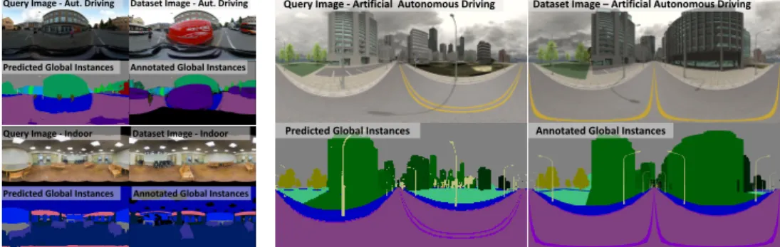
Query Image - Aut. Driving Dataset Image - Aut. Driving
Predicted Global Instances Annotated Global Instances
Query Image - Indoor Dataset Image - Indoor
Predicted Global Instances Annotated Global Instances
Query Image - Artificial Autonomous Driving Dataset Image –Artificial Autonomous Driving
Predicted Global Instances Annotated Global Instances
Figure 1: This figure showsglobally unique instance segmentationand corresponding localisation results for outdoor (top left quadrant), indoor (bottom left quadrant) and artificial data (right quadrant). The left two images of each quadrant correspond to the query image and the predicted labels while the image pair on the right corresponds to the best matching image in the database and the corresponding labels. Note the high quality of the segmentation and localisation under changes in illumination (out-door images), viewpoint, in the presence of smooth surfaces with little texture (in(out-door images) and in the case of significant changes to the map due to missing buildings (artificial images).
bounding box which does not contain enough information for most robot interaction tasks such as grasping. Conversely, the non object-specific output of typical semantic class
seg-mentation [61] (or detection [50]) methods severely limits the interaction possibilities of
an autonomous agent. Similarly, object instance segmentation [22] frameworks often
pro-duce inconsistent labels accross queries, thus preventing decision making accross time.
Fi-nally, standard localisation approaches [3, 26, 63] indicate only a location in a map,
ei-ther as a 6DoF camera pose prediction [26] or by specifying the most similar image in a
database [3,63] without providing semantic information about the surrounding environment.
In this work, we propose to address the aforementioned problems by utilizingglobally
unique object instance segmentation- a sub-task of semantic segmentation. For such a task,
each object of interest within the operating environment is assigned a label mask with a
globally unique instance id, as shown in Figure1. Using this data for training a semantic
segmentation network, we obtain a model which may be used for simultaneous localisa-tion, surrounding object recognition and segmentation. Localisation is performed in a two-step procedure. First, fast histogram matching is performed between the predicted labels of the query image and the database label images, resulting in a small number (~100) of well matching candidate frames. Then, a further refinement using a slower but more accurate label image alignment in 3 degrees of freedom (yaw, pitch, roll) is carried out.
We evaluated the proposed algorithm on multiple real and artificial datasets. We created
an artificial autonomous driving dataset using the SceneCity [2] tool and collected real world
data by tracing the original path of the CamVid [9] dataset using a panoramic Ricoh Theta
S camera. We used the Stanford 2D-3D-S [6] dataset for indoor experiments. We obtained
high localisation accuracy (above 98%) and high segmentation accuracy (above 94% global and 52% class average for 837 object labels) on autonomous driving scenarios. While we achieved relatively lower segmentation accuracy (61% global and 38% class average for 3138 object labels) for challenging, low-texture indoor experiments, we still obtained an 11% higher localisation accuracy than classical approaches of localisation based on keypoint
matching [29, 63] or image embedding [3]. Our contribution includes: (i) a description
of a novel semantic localisation approach usingglobally unique instance segmentation, (ii)
BUDVYTIS, SAUER, CIPOLLA: SEMANTIC LOCALISATION
986 labelled instances of buildings, trees, road signs and poles.
The rest of this work is divided as follows. Section2discusses relevant work in
seman-tic segmentation and localisation. Section 3 provides details of our proposed localisation
approach. Sections4and5describe the experiment setup and corresponding results.
2
Related Work
In this section we provide a discussion of various approaches to semantic segmentation and localisation which are related to our work.
Semantic segmentation. In the field of Computer Vision, semantic segmentation encom-passes various approaches to grouping pixels in images or videos. For example, class
seg-mentation [9,52] is concerned with grouping pixels of the same object class (e.g. buildings,
trees or tables), whereas instance segmentation [22] aims to group pixels belonging to the
same object within the target image. Panoptic segmentation [28] is concerned with
combin-ing class segmentation output and instance segmentation output. In contrast to the
afore-mentioned semantic segmentation approaches,globally unique instance segmentationaims
to group pixels of the same object across the whole operating environment, thus providing both segmentation and recognition simultaneously.
Image retrieval based localisation. A large subset of localisation approaches formulate localisation as an image retrieval problem. They identify the most similar looking image in a database primarily in two ways by employing either (i) a pipeline of keypoint detection
and matching [29,63] or (ii) fast-to-compare image level encoding [3,55]. Approaches of
the first type often have large storage requirements and relatively slow matching procedures.
Methods of the latter type are significantly faster, yet as suggested in [37] are more likely
to be sensitive to large occlusions and scene changes1. Both types of approach provide a
location for the whole scene and not of individual objects.
3D geometry based localisation. Another large group of localisation approaches work by explicitly recovering 3D geometry of the environment using 3D sensors such as structured
light [24,46], time of flight [60] cameras as well as RGB based structure from motion [54]
or mixed [6] approaches. Such works perform 3D matching between locally reconstructed
3D scenes and pre-built 3D maps either by using depth information only [24], or by using a
combination of depth and appearance information [18]. A 6DoF camera pose is recovered as
result. The majority of such approaches are computationally expensive and require relatively
large amounts of memory for storage of the environment map. Some recent techniques [26]
attempt to improve query time performance by recovering 6DoF camera pose using deep neural networks without an explicit 3D geometry estimation. In contrast to this, and as with image retrieval-based localisation, our proposed method not only provides a camera location estimate but also indicates surrounding objects. It also may be used to augment the aforementioned approaches, or use them to perform a refinement of the outputs.
Semantic localisation. Works attempting to incorporate semantic information into locali-sation often take one of three approaches. Methods in the first group perform either explict
filtering [35] or use feature reweighting [27,47] in order to filter out uninformative classes
of objects (e.g. cars, people) when performing image matching. Methods in the second
group attempt to fit 3D models (e.g. CAD) of a single room [44] or building [13,14] or of
detailed maps [12,38] as well as a combination of less precise information such as a single
1It is important to note that in our experiments described in Section5with NetVlad [3], a high tolerance for
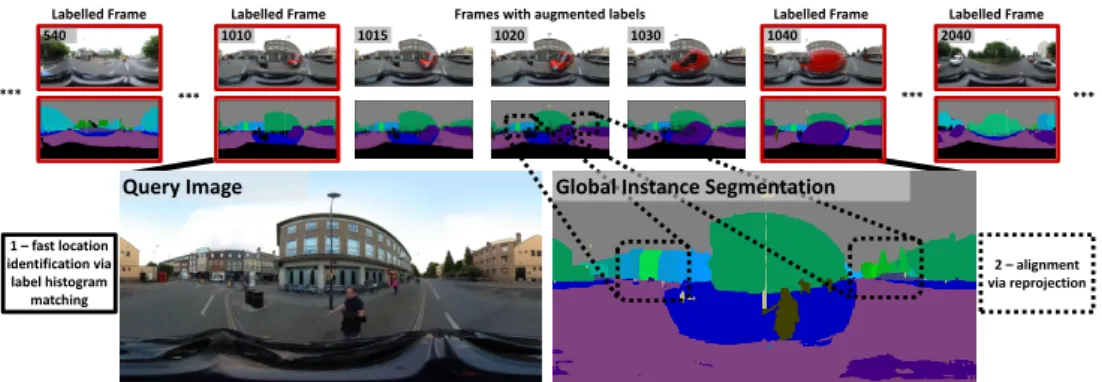
BUDVYTIS, SAUER, CIPOLLA: SEMANTIC LOCALISATION 2 –alignment via reprojection 1020 1010 1015 1030 1040 2040 540 1 –fast location identification via label histogram matching *** *** *** *** Labelled Frame
Labelled Frame Frames with augmented labels Labelled Frame Labelled Frame
Query Image Global Instance Segmentation
Figure 2: This figure illustrates the key steps of our proposed localisation framework. Firstly, a database of panoramic RGB images and correspondingglobally unique, per-pixel object instance la-belsis built for the desired environment. A multi-class label propagation [10] method is used to propa-gate labels between key labelled frames (marked with red borders). Secondly, a semantic segmentation network capable of predicting more than 3000 labels is trained on the collected data. Finally, for a given panoramic query image, the corresponding instance label image predicted by the network is used for semantic matching within the database. The matching is performed in two stages. During the first step, a fast label histogram matching is performed in order to predict an approximate location. During the second step, the predicted location is further refined by finding the label image in the database which best agrees with the predicted instances. See Section3for more details.
large building floor plan [32,57] or of multiple building 2D layout and corresponding height
information [4, 5, 23]. The final group of methods employ direct learning of classifiers
to output a GPS location [21,59], or a bounding box of a specific building [64]. The first
family of approaches aims to improve localisation accuracy, yet does not provide semantic information (e.g. identification of surrounding objects) about the environment. Methods in the second group require expensive-to-build maps and complex fitting techniques. Note that
while [57] uses easy-to-obtain existing building plans it heavily relies on locations having
informative textual information. The examples from the final group demonstrate only coarse localisation capability. Our method can be viewed as a member of this group.
Datasets. While the advent of deep learning has seen a proliferation of various datasets,
obtaining a dataset which would contain both (i) panoramic videos2(or large sets of images
densely sampled at different views) and (ii) large amount globally unique object instance labels for indoor or autonomous driving scenarious is not easily available. For example,
many of the popular real-world datasets for autonomous driving [9,15,19,30,36] or
lo-calisation [12, 37,56] lack one or the other. Even artificial datasets [17,25, 40,42], or
simulators [16,34,39,41,51] often do not provide the ability to sample equirectangular
im-ages, obtain instance labels of static objects or provide only very limited urban landscapes. In order to evaluate our localisation method, we collected our own real world and virtual datasets for autonomous driving. For real indoor environments, we were able to identify
only the Stanford 2D-3D-S [6] dataset to contain instance segmentations of equirectangular
images, which we use in this work. Note that the Matterport 3D dataset [11] provides
la-belled meshes, however labels for equirectangular images are not provided. Artificial highly
realistic indoor datasets [31,39,45] suffer from similar issues as autonomous driving,
pre-venting from convenient sampling of rich, large scale, photo-realistic, equirectangular videos with various object instance labels.
2We chose panoramic as opposed standard small field of view images for our experiments in order to emphasise
BUDVYTIS, SAUER, CIPOLLA: SEMANTIC LOCALISATION
3
Method
Our proposed semantic localisation framework comprises three key steps: (i) collecting a database of labelled images from the environment, (ii) training a globally unique instance segmentation network and (iii) matching the prediction on the a given query image with the best labelled image in the collected database. A detailed description of each step is provided
bellow. See Figure2for an illustration.
Collecting labelled database. The database collection for the desired environment consists of three steps. Firstly, a set of panoramic images of the environment is obtained by capturing panoramic videos (real data) or by dense sampling of still images (artificial data). Secondly, a subset of those images (e.g. every 30th frame) are labeled with globally unique instance
labels. Finally, an original implementation of label propagation method [10] is used to extend
the labels for the rest of the image set at full resolution with parameters of patch size p=
7, cross-correlation window dimensionsW×H=200×100 and label similarity constant
δ =0.001 set empirically by following recommendations of [10]. Note that for experiments
described in this work, key frames were hand labelled, however semi-automatic methods
making use of instance segmentation such as Mask-RCNN [22] or 3D map alignment [38]
could be employed in the future.
Training a segmentation network.Once a dataset of labelled images is collected, a
seman-tic segmentation network is trained. We use theModel Avariant of wide shallow residual
networks [61]. It is trained for 200 epochs using four standard Titan X GPUs and batch size
of 12 samples. Weights are initialized from a network pretrained on ImageNet [43] dataset.
Initial learning rate of 0.0001 is chosen and gradually reduced using linear schedule [33].
Note that we amended the original implementation of [61] by removing the upsampling
layer. The resulting network works well up to 4000 class labels per pixel at a moderate com-putational cost. This is enough to cover significant areas of interest, especially when only a subset of objects of a class of interest receives globally unique instance labels. Also note that multiple local networks can be learned to cover even larger areas, and techniques based on
hierarchical classification [53] and embedding [8] can be used to further increase scalability.
Localisation. For any query image, a two step procedure is performed. Firstly, a small set (~100) of the highest-matching database images in the label histogram domain is found
using the distance functionMhist. Then, an explicit alignment of query and database label
images is performed in order to find the best match under any possible rotation (distance
functionMalig). The label histogram matching scoreMhistranks pairs of label images by the
number of different labels appearing in both images (|Lcom|), followed by a ranking using the
average (per-label) upper bound of intersection over union score (MIoU Hist). It is computed
as follows:
Mhist=αMIoU Hist+β|Lcom|, (1)
where
MIoU Hist(Q,D) =
∑∀l∈LcomIoUupper(Q,D,l)
|Lcom| . (2)
Here,
IoUupper(Q,D,l) =
min(|Q(l)|,|D(l)|)
max(|Q(l)|,|D(l)|) (3)
is an upper bound of the intersection over union (IoU) score3between the query (Q) and
database (D) images for labell. Q(l)andD(l)are the sets of pixels having class labell
3Note that the intersection over union for labellcan be defined asIoU=|Q(l)∩D(l)| |Q(l)∪D(l)|.
BUDVYTIS, SAUER, CIPOLLA: SEMANTIC LOCALISATION
for imagesQ andDrespectively. Lcom= (LQ∪LD)−LQf ilt, where LQ is a set of labels
in the query image,LD is a set of labels in the database image andLQf ilt is a set of labels
which have less thandpixels (we used=20) in the query image.LQf ilt labels are excluded
in order to gain robustness to miss-prediction of small objects. Also note that unlabelled pixels in database images are assigned a "void" label and are excluded from the matching calculation, as are dynamic classes (e.g. cars, pedestrians for autonomous driving scenarios).
We empirically setα=1.0 andβ=1.0. In order to rank images during the second step, the
upper bound of the intersection over union (MIoU Hist) is replaced with an estimation of the
IoU score which utilises full label images (MIoU Est), resulting in the following definition of
Malig=αMIoU Est+β|Lcom|. (4)
Here
MIoU Est(Q,D) =min∀R∈ROT
∑∀l∈LcomIoUest(R(Q),D,l)
|Lcom|
, (5)
whereROT is the set of 3D rotations (yaw, pitch, roll) considered, R(Q)is a label image
rotated byRand IoUest= |R(Q)(l)| ∗|RQ 0 (l)∩D(l)| |RQ0(l)| |R(Q)(l)∪D(l)| (6)
is an estimation of an IoU score for a class labellfor imagesR(Q)andD. HereRQ0(l)is a
small subset (40 samples, set empirically) of randomly sampled pixels fromR(Q)(l). Note
that for the experiments described in this workROT consists of angles sampled at every
1◦in interval (±20◦,±20◦,±180◦) for (yaw, pitch, roll). It is important to note that label
histogram matching algorithm is very efficient, taking less than 1 millisecond to evaluate more than 10000 matches even with a simple implementation. Dedicated data structures designed for fast item retrieval could be used for further improvement. While label image alignment matching is slower, it provides more accurate image level matches and can output the 3DoF camera view details. Our simple implementation achieved 60 FPS for 100 matches on a Titan X GPU and can also be significantly sped up by further optimising the code, which is out of the scope of this work.
4
Experimental Setup
In this section we describe the datasets used for indoor and autonomous driving scenarios and explain the protocol for evaluation.
SceneCity dataset. SceneCity [2] is a Blender [1] plugin for creating artifically generated 3D urban landscapes. The generation process can be controlled via multiple environmental parameters such as the amount of water and mountains, the road network density, the build-ing size distribution and other parameters. This tool was used to generate three city maps
for our experiments, examples of which can be seen in Figures1and3as well as in
sup-plementary material. The first city map was borrowed from [65]. This city contained 102
buildings and 156 road segments4. To create the map for the second city, 20% of buildings
were removed from the first city at random. The final city map was generated from scratch
using the SceneCity [2] tool, resulting in 827 buildings and 966 road segments. Semantic
4Note that each road segment is a unit square (1×1) in original SceneCity coordinates correspond to the size of
BUDVYTIS, SAUER, CIPOLLA: SEMANTIC LOCALISATION
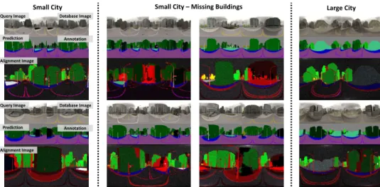
Small City Small City –Missing Buildings Large City Query Image Database Image
Alignment Image
Prediction Annotation
Query Image Database Image
Alignment Image
Prediction Annotation
Figure 3: This figure illustrates qualitative results for globally unique instance segmentation and localisation in three artificial SceneCity datasets corresponding to a small city, a small city with missing buildings and a large city model. Alignment images are built by finding the best alignment between the query label image and the database label image, followed by subsequent colouring of pixels of the wrongly predicted label in red. Pixel colours are enhanced for better visibility. Note the high quality of segmentation and alignment for all images. Also note how missing buildings can be identified by large regions of red. Zoom in for better view. See supplementary material for more results.
labelling of 11 class labels (e.g. road, pole, etc.) were used for all three cities.
Correspond-ing image databases were created by samplCorrespond-ing images (2048×1024) at the centers of road
segments and at 6 intermediate point coordinates along the centers (with an elevation of 0.064 units above the road) of two neighbouring road segments, resulting in a total of 1146 and 6774 images for the small and large cities, respectively. For all experiments, a cloudy sky lighting with randomly changing rotation of the sun was chosen. Query images for the small city were obtained by sampling 300 images from the original camera path provided
in [65]. Query images for the large city consisted of 1000 samples at the center of road
segments taken at an elevation of 0.064 units above the road and at a random deviation up
to(±0.14,±0.14,±0.014)units in (X, Y, Z). The aforementioned dataset was generated in
order to evaluate our proposed method for localisation under large, highly repetitive maps as well as under changes in the environment between data captures.
CamVid-360 dataset. CamVid-360 is a dataset of panoramic videos captured by cycling
along the original path of the CamVid [9] dataset using a Ricoh Theta S camera. It provides
an evaluation of proposed method for a real world autonomous driving scenario. As in the SceneCity experiments, CamVid-360 is divided into two sets of images. The database
consists of 7835 images (sampled at 30 fps, 1920×960) tracing sequences 016E5, 001TP
from the original CamVid dataset [9]. The query image set consists of 266 images (sampled
at 1 fps) tracing sequences 016E5, 001TP and 006R0, the latter corresponding to parts of the city which are not represented in the database. The database images are labelled using the
protocol explained in Section3with one of 11 semantic classes and multiple globally unique
object instance labels of buildings and trees, resulting in 298 and 142 instances, respectively.
Examples of CamVid-360 images and labels can be found in Figures 1, 2, 4 and in the
supplementary material. Finally, in order to create the ground truth for localisation, each query image was manually assigned the best matching image in the database.
BUDVYTIS, SAUER, CIPOLLA: SEMANTIC LOCALISATION
(a) Query Image Database Image Alignment Image Prediction Annotation Object Classes Building Instances Building and Tree Instances
Query Image Database Image
Alignment Image Prediction Annotation
Query Image Database Image
Alignment Image Prediction Annotation
(b)
(iv) - SIFT
(v) - LIFT
(i) –Object class segmentation (ii) –Building instance segmentation
(iii) - Building and tree instance segmentation
(vi) - NetVlad Figure 4: Figure (a) illustrates qualitative results on the CamVid-360 dataset. It follows the same visualisation format as Figure3. Note a high accuracy overlap of class labels in different locations (row 1, column 2). Also note that errors in image alignment seem to be mainly introduced by the horizontal translation relative to the motion path in the database. Figure (b) shows matching accuracy as a function of changing the confidence threshold normalized for the percentage of images accepted (acceptance rate) at multiple error tolerances of±1,±5 and±15 frames.
images from 6 indoor areas and 270 locations. 13 class labels (e.g. ceiling, table, etc.) and 6005 corresponding object instance labels are provided. This dataset is used for evaluating our proposed localisation method for indoor robotics scenario. As with previous experi-ments, we randomly split the dataset into an environment image database (1180 images) and a query image set (233 images). When creating the split, it is ensured that at least one image of each location is contained in both subsets of the datasets. Also images were resized to
2048×1024. The proposed localisation method is evaluated under multiple scenarios: when
using only class labels (11 in total), using class labels and instances of walls, ceilings and floors (2184 in total) as well as when using all static object instances (3138 in total). Note that we define an object as static if it is not likely to be moved in a room (e.g. bookshelf). Examples of images from Stanford-2D-3D-S and corresponding labellings can be found in
Figures1,6, and in the supplementary material.
Evaluation protocol.We evaluated our proposed semantic localisation method by
measur-ing thematching accuracy(MA), defined asMA=CM+CMIM+NM, whereCMandIMare
num-bers of correctly and incorrectly matched query images which have a ground truth match in
the database, andNMis the number of images which were assigned a match but do not have
a ground truth match in the database (only applies for CamVid-360 experiments). For the SceneCity experiments, a match was considered to be correct if query image was matched to the closed database image in Euclidean distance. For the CamVid-360 experiments, the matching accuracy was evaluated under three different settings, each considering a match
to be correct if the predicted database image was within a range of±1,±5 and±15 video
frames from the ground truth match, respectively. Finally, for indoor experiments, a match was considered to be correct if the query image and the recovered database image were taken
in the same room. For all experiments (see Figures5and 6(b)), accuracies were reported
for the 95% acceptance rate(AR), which corresponds to a ratio between the number of
query images which have a ground truth match in a database and pass a chosen confidence threshold with the total number of images which have a ground truth match in a database. The acceptance rate is used in order to avoid low confidence predictions affecting matching
BUDVYTIS, SAUER, CIPOLLA: SEMANTIC LOCALISATION
(a)Localisation Method
Match Function
Small City Small City –Missing
Buildings (20%) Large City Lab. MA GA CA IoU Lab. MA GA CA IoU Lab. MA GA CA IoU
Class Only Hist. 11 77 96 78 69 11 24 97 77 68 11 80 97 78 71
Alig. 94 44 100 Building Instances Hist. 112100 96 79 69 112 86 94 66 50 837 98 94 52 37 Alig. 100 100 100 SIFT # of Dsc. N/A 100 N/A N/A 94 N/A N/A 98 N/A LIFT # of Dsc. 83 73 97
NetVLAD Euc. Dist. 100 99 58
(b) Localisation Method Matching Function Lab. W +/- 1 W +/- 5 W +/- 15 MA MA MA
Class Only Hist. 11 7 16 31
Alig. 33 60 70 Building Instances Hist. 308 18 48 81 Alig. 43 83 98 Building and Tree Instances Hist. 450 17 47 84 Alig. 38 80 98 SIFT # of Desc. N/A 71 99 99 LIFT # of Desc. 64 98 99
NetVLAD Euc. Dist. 50 90 98
Figure 5: Figure (a) illustrates quantitative results of comparing various localisation approaches on three artificial cities. It reports matching accuracy (MA) for the best matches and segmentation quality (GA - global accuracy, CA - class accuracy, IoU - mean intersection over union). The aforementioned metrics are reported both for localisation via label histogram matching and more for computation-ally expensive matching using image alignment. Figure (b) shows the quantitative evaluation on the CamVid-360 dataset. It evaluates the proposed localisation method under three different error tolerance settings for correct matches (±1,±5,±15 frames). See Figure4(a) for qualitative results.
We also reported global accuracy, class accuracy of per-pixel segmentation as well as mean intersection over union score (IoU) for the SceneCity and Stanford-2D-3D-S datasets where the ground truth segmentation is readily available for the query images. We compared our semantic localisation method with classic localisation techniques based on hand-designed
SIFT [29] features, learnt LIFT [63] features and NetVlad [3] image embedding. For SIFT
and LIFT based localisation we defined matching confidence by counting the number of well matching (ratio of distances between nearest neighbours higher than 0.8) feature descriptors.
For the NetVlad [3] method we used the Euclidean distance between image embedding
vec-tors as a confidence score directly.
5
Results
In this section we discuss the results of the previously described experiments.
SceneCity dataset. Figures3 and5(a) provide qualitative and quantitative results on ar-tificially generated cities. Our proposed localisation method attains high localization and segmentation accuracies. As expected, localisation accuracies for our method using label histogram matching are greatly improved on all three city map setups when building in-stances are used, the smallest increase being 18% in the case of the large city map. Similarly, using label image alignment for location refinement provides a significant improvement both when object class labels and building instances are employed, resulting in a 20% and 14% respective improvement in the small city map with missing buildings. More surprisingly, label histogram localisation using building instance labels performs at the same accuracy or better in all cities except in the case of the small city with missing buildings when compared
to classical localisation approaches (LIFT [63], SIFT [29], NetVlad [3]). Semantic
locali-sation using label image alignment and building instances outperforms all other techniques,
including the difficult scenario of missing buildings, as demonstrated in Figure3. Also note
that in the case of missing buildings, the relatively good performance of NetVlad [3]
locali-sation contrasts with previous claims [37]. While more investigation is needed, our current
hypothesis is that image embedding techniques are more sensitive to increases in map size (only 58% MA) than to local changes in the map. We would however expect the changes in the map to have a larger impact as the size of the environment increases.
CamVid-360 dataset.Figures4and5(b) provide quantitative and qualitative results for the CamVid-360 dataset. As in the artificial data experiments, the same trends of significant increases in accuracy as a result of (i) using instance labels instead of class labels and (ii)
BUDVYTIS, SAUER, CIPOLLA: SEMANTIC LOCALISATION (a) Class only Wall, ceiling and floor instances All Static Object Classes
Query Image Database Image
Prediction GT Labels
Query Image Database Image
Prediction GT Labels
Query Image Database Image
Prediction GT Labels
(b) Localisation Method
Match
FunctionLab. MA GA CA IoU
Class only Label Hist. 12 17 90 78 60 Image Alig. 20 Wall, ceiling, floor instances Label Hist. 2184 76 65 44 18 Image Alig. 63 All static instances Label Hist. 3138 77 61 38 15 Image Alig. 74 SIFT # of Dsc. N/A 55 N/A LIFT # of Dsc. 47 NetVLAD Euc. Dist. 66
Figure 6: This figure illustrates qualitative (a) and quantitative (b) results on the Stanford-2D-3D-S indoor dataset, respectively. While instance segmentation accuracy (also reflected quantitatively) is relatively lower than in the case of the artificial data experiments or the CamVid-360 dataset, the matching accuracy outperforms classical localisation techniques.
employing label image alignment over class histogram matching can be observed. While
localisation accuracy is rather low in the case of the low error tolerance settings, i.e. ±1
and±5 frames, it is within 1% of classical localisation algorithms for the least conservative
setting (±15), which still corresponds to localising within the hand-labelled frames. A worse
relative performance compared to artificial city experiments can be primarily explained by (i) not accounting for translation in image alignment and (ii) by insuficient lighting augmen-tation. The former could be addressed by utilizing semantic 3D point clouds of the database
images. The latter can be addressed by GAN-enabled data augmentation [58,62]. Finally,
Figure4(b) confirms that confidence scores of both instance-based semantic localisation and
classical techniques eliminate the majority of incorrect matches at an acceptance rate lower than 95-98%.
Stanford 2D-3D-S dataset. Qualitative and quantitative results for indoor experiments can
be found in Figure6. Similarly to the results for autonomous driving scenerios, an increase
in the number of instances used leads to an increase in matching accuracy. However, dif-ferently than in previous experiments, simple class histogram matching outperformed label image alignment matching. This is expected, as relatively large translation is present be-tween the database and query images. Nevertheless our technique significantly outperformed
SIFT [29], LIFT [63] and NetVlad [3] which, especially in the case of key-point matching
techniques, suffer in the case of lacking surface texture. Also note the high tolerance of our proposed localisation method to relatively low segmentation accuracies when compared to previous experiments. This is due to the low likelihood of miss-predicted object labels having geographically close locations.
6
Conclusions
In this work, we proposed a novel approach to semantic localisation consisting of three key
steps: (i) building a database of panoramic RGB images and correspondingglobally unique
object instancemasks for the desired environment, (ii) training a semantic segmentation
net-work on the collected data and (iii) using a predicted global unique object instance mask image for semantic matching within the database. This method not only provided an abil-ity to localise within a desired database, but also to segment and recognise objects from the surrounding environment. This is necessary for active vision applications such as au-tonomous driving, augmented reality and robotics. Quantitative and qualitative evaluation on indoor and autonomous driving scenerios demonstrated promising results. Our method
BUDVYTIS, SAUER, CIPOLLA: SEMANTIC LOCALISATION
References
[1] Free and open source 3D creation suite. https://www.blender.org/.
Ac-cessed: 2018-04-29.
[2] SceneCity - Build Cities in Blender. https://www.cgchan.com/store/
scenecity. Accessed: 2018-04-29.
[3] R. Arandjelovi´c, P. Gronat, A. Torii, T. Pajdla, and J. Sivic. NetVLAD: CNN
architec-ture for weakly supervised place recognition. InIEEE Conference on Computer Vision
and Pattern Recognition (CVPR), June 2016.
[4] A. Armagan, M. Hirzer, P. M. Roth, and V. Lepetit. Learning to align semantic
seg-mentation and 2.5D maps for geolocalization. InIEEE Conference on Computer Vision
and Pattern Recognition (CVPR), July 2017.
[5] A. Armagan, M. Hirzer, P. M. Roth, and V. Lepetit. Accurate camera registration in
urban environments using high-level feature matching. InProceedings of the British
Machine Vision Conference (BMVC), September 2017.
[6] I. Armeni, A. Sax, A. R. Zamir, and S. Savarese. Joint 2D-3D-Semantic Data for Indoor
Scene Understanding.ArXiv e-prints, February 2017.
[7] M. Bojarski, D. D. Testa, D. Dworakowski, B. Firner, B. Flepp, P. Goyal, L. D. Jackel, M. Monfort, U. Muller, J. Zhang, X. Zhang, J. Zhao, and K. Zieba. End to end learning
for self-driving cars.CoRR, abs/1604.07316, 2016.
[8] B. D. Brabandere, D. Neven, and L.V. Gool. Semantic instance segmentation with a
discriminative loss function. InDeep Learning for Robotic Vision workshop in IEEE
Conference on Computer Vision and Pattern Recognition (CVPR), July 2017.
[9] G. J. Brostow, J. Fauqueur, and R. Cipolla. Semantic object classes in video: A
high-definition ground truth database.Pattern Recognition Letters, 30(2):88–97, 2009.
[10] I. Budvytis, P. Sauer, T. Roddick, K. Breen, and R. Cipolla. Large scale labelled video
data augmentation for semantic segmentation in driving scenarios. In5th Workshop
on Computer Vision for Road Scene Understanding and Autonomous Driving in IEEE
International Conference on Computer Vision (ICCV), October 2017.
[11] A. X. Chang, A. Dai, T. A. Funkhouser, M. Halber, M. Nießner, M. Savva, S. Song, A. Zeng, and Y. Zhang. Matterport3D: learning from RGB-D data in indoor
environ-ments. InInternational Conference on 3D Vision (3DV), October 2018.
[12] D. M. Chen, G. Baatz, K. Köser, S. S. Tsai, R. Vedantham, T. Pylvänäinen, K. Roimela, X. Chen, J. Bach, M. Pollefeys, B. Girod, and R. Grzeszczuk. City-scale landmark
identification on mobile devices. InIEEE Conference on Computer Vision and Pattern
Recognition (CVPR), June 2011.
[13] H. Chu, S. Wang, R. Urtasun, and S. Fidler. Housecraft: Building houses from rental
ads and street views. InEuropean Conference on Computer Vision (ECCV), October
BUDVYTIS, SAUER, CIPOLLA: SEMANTIC LOCALISATION
[14] A. Cohen, J. L. Schönberger, P. Speciale, T. Sattler, J. M. Frahm, and M. Pollefeys.
Indoor-outdoor 3D reconstruction alignment. InEuropean Conference on Computer
Vision (ECCV), October 2016.
[15] M. Cordts, M. Omran, S. Ramos, T. Rehfeld, M. Enzweiler, R. Benenson, U. Franke, S. Roth, and B. Schiele. The cityscapes dataset for semantic urban scene understanding.
InIEEE Conference on Computer Vision and Pattern Recognition (CVPR), June 2016.
[16] A. Dosovitskiy, G. Ros, F. Codevilla, A. Lopez, and V. Koltun. CARLA: An open urban
driving simulator. InProceedings of the 1st Annual Conference on Robot Learning,
November 2017.
[17] A. Gaidon, Q. Wang, Y. Cabon, and E. Vig. Virtual worlds as proxy for multi-object
tracking analysis. InIEEE Conference on Computer Vision and Pattern Recognition
(CVPR), June 2016.
[18] X. Gao and T. Zhang. Robust RGB-D simultaneous localization and mapping using
planar point features.Robotics and Autonomous Systems, 72:1 – 14, 2015. ISSN
0921-8890.
[19] A. Geiger, P. Lenz, and R. Urtasun. Are we ready for autonomous driving? The KITTI
vision benchmark suite. InIEEE Conference on Computer Vision and Pattern
Recog-nition (CVPR), June 2012.
[20] L. Goode and T. Warren. This is what microsoft hololens is really like.
2015. URL https://www.theverge.com/2016/4/1/11334488/
microsofthololens-video-augmented-reality-ar-headset-hands-on.
[21] P. Gronát, G. Obozinski, J. Sivic, and T. Pajdla. Learning and calibrating per-location
classifiers for visual place recognition. InIEEE Conference on Computer Vision and
Pattern Recognition (CVPR), June 2013.
[22] K. He, G. Gkioxari, P. Dollár, and R. Girshick. Mask R-CNN. InProceedings of the
International Conference on Computer Vision (ICCV), October 2017.
[23] M. Hirzer, C. Arth, P. M. Roth, and V. Lepetit. Efficient 3D tracking in urban
envi-ronments with semantic segmentation. InProceedings of the British Machine Vision
Conference (BMVC), September 2017.
[24] S. Izadi, D. Kim, O. Hilliges, D. Molyneaux, R. Newcombe, P. Kohli, J. Shotton, S. Hodges, D. Freeman, A. Davison, and A. Fitzgibbon. Kinectfusion: real-time 3D
reconstruction and interaction using a moving depth camera. InProceedings of the 24th
Annual ACM Symposium on User interface Software and Technology, October 2011.
[25] D. H. Juárez, L. Schneider, A. Espinosa, D. Vázquez, A. M. López, U. Franke, M. Pollefeys, and J. C. Moure. Slanted stixels: Representing San Francisco’s steepest
streets. InProceedings of the British Machine Vision Conference (BMVC), September
2017.
[26] A. Kendall, M. Grimes, and R. Cipolla. PoseNet: a convolutional network for
real-time 6-DOF camera relocalization. InProceedings of the International Conference on
BUDVYTIS, SAUER, CIPOLLA: SEMANTIC LOCALISATION
[27] H. J. Kim, E. Dunn, and J. M. Frahm. Learned contextual feature reweighting for image
geo-localization. InIEEE Conference on Computer Vision and Pattern Recognition
(CVPR), July 2017.
[28] A. Kirillov, K. He, R. B. Girshick, C. Rother, and P. Dollár. Panoptic segmentation.
ArXiv, 2018.
[29] D. G. Lowe. Distinctive image features from scale-invariant keypoints. International
Journal of Computer Vision (IJCV), 60(2):91–110, November 2004.
[30] W. Maddern, G. Pascoe, C. Linegar, and P. Newman. 1 Year, 1000km: The Oxford
RobotCar Dataset. The International Journal of Robotics Research (IJRR), 36(1):3–
15, 2016.
[31] J. McCormac, A. Handa, S. Leutenegger, and A. J. Davison. SceneNet RGB-D: can 5m
synthetic images beat generic imagenet pre-training on indoor segmentation? In
Pro-ceedings of the International Conference on Computer Vision (ICCV), October 2017.
[32] O. Mendez, S. Hadfield, N. Pugeault, and R. Bowden. Sedar-semantic detection and
ranging: Humans can localise without lidar, can robots? InIEEE International
Con-ference on Robotics and Automation, May 2018.
[33] D. Mishkin, N. Sergievskiy, and J. Matas. Systematic evaluation of cnn advances on the
ImageNet.Computer Vision and Image Understanding, 161(C):11–19, August 2017.
[34] M. Mueller, V. Casser, J. Lahoud, N. Smith, and B. Ghanem. UE4Sim: a photo-realistic
simulator for computer vision applications. International Journal of Computer Vision
(ICJV), 2018.
[35] T. Naseer, G. Oliveira, T. Brox, and W. Burgard. Semantics-aware visual
localiza-tion under challenging perceptual condilocaliza-tions. InIEEE International Conference on
Robotics and Automation (ICRA), May 2017.
[36] G. Neuhold, T. Ollmann, S. R. Buló, and P. Kontschieder. The Mapillary Vistas dataset
for semantic understanding of street scenes. InIEEE International Conference on
Com-puter Vision (ICCV), October 2017.
[37] H. Noh, A. Araujo, J. Sim, T. Weyand, and B. Han. Large-scale image retrieval with
attentive deep local features. InIEEE International Conference on Computer Vision,
(ICCV), October 2017.
[38] T. Pylvänäinen, K. Roimela, R. Vedantham, R. Wang, and R. Grzeszczuk. Automatic alignment and multi-view segmentation of street view data using 3d shape priors. In
Symposium on 3D Data Processing, Visualization and Transmission (3DPVT),
Decem-ber 2010.
[39] W. Qiu, F. Zhong, Y. Zhang, S. Qiao, Z. Xiao, T. S. Kim, Y. Wang, and A. Yuille.
UnrealCV: virtual worlds for computer vision. InProceedings of ACM on Multimedia
Conference, October 2017.
[40] S. R. Richter, V. Vineet, S. Roth, and V. Koltun. Playing for data: Ground truth from
BUDVYTIS, SAUER, CIPOLLA: SEMANTIC LOCALISATION
[41] S. R. Richter, Z. Hayder, and V. Koltun. Playing for benchmarks. InInternational
Conference on Computer Vision (ICCV), October 2017.
[42] G. Ros, L. Sellart, J. Materzynska, D. Vazquez, and A. Lopez. The SYNTHIA Dataset: A large collection of synthetic images for semantic segmentation of urban scenes. In
IEEE Conference on Computer Vision and Pattern Recognition (CVPR), June 2016.
[43] O. Russakovsky, J. Deng, H. Su, J. Krause, S. Satheesh, S. Ma, Z. Huang, A. Karpathy, A. Khosla, M. Bernstein, A. C. Berg, and L. Fei-Fei. Imagenet large scale visual
recognition challenge. International Journal of Computer Vision, 115(3):211–252, 12
2015.
[44] S. Satkin, J. Lin, and M. Hebert. Data-driven scene understanding from 3D models. In
Proceedings of British Machine Vision Conference (BMVC), September 2012.
[45] Manolis Savva, Angel X. Chang, Alexey Dosovitskiy, Thomas Funkhouser, and Vladlen Koltun. MINOS: Multimodal indoor simulator for navigation in complex
en-vironments.arXiv:1712.03931, 2017.
[46] D. Scharstein and R. Szeliski. High-accuracy stereo depth maps using structured light.
InIEEE Conference on Computer Vision and Pattern Recognition (CVPR), June 2003.
[47] J. L. Schönberger, M. Pollefeys, A. Geiger, and T. Sattler. Semantic visual localization.
InIEEE Conference on Computer Vision and Pattern Recognition (CVPR), June 2018.
[48] F. Schroff, D. Kalenichenko, and J. Philbin. FaceNet: a unified embedding for face
recognition and clustering. In IEEE Conference on Computer Vision and Pattern
Recognition (CVPR), June 2015.
[49] M. Schwarz, C. Lenz, G. M. Garcia, S. Koo, A. S. Periyasamy, M. Schreiber, and S. Behnke. Fast object learning and dual-arm coordination for cluttered stowing,
pick-ing, and packing. In IEEE International Conference on Robotics and Automation
(ICRA), May 2018.
[50] M. Schwarz, A. Milan, A. S. Periyasamy, and S. Behnke. Rgb-d object detection
and semantic segmentation for autonomous manipulation in clutter. The International
Journal of Robotics Research, 37(4-5):437–451, 2018.
[51] S. Shah, D. Dey, C. Lovett, and A. Kapoor. AirSim: high-fidelity visual and physical
simulation for autonomous vehicles. InField and Service Robotics, 2017.
[52] J. Shotton, J. Winn, C. Rother, and A. Criminisi. Textonboost for image understanding: Multi-class object recognition and segmentation by jointly modeling texture, layout,
and context.International Journal of Computer Vision, 81(1):2–23, Jan 2009.
[53] C. N. Silla and A. A. Freitas. A survey of hierarchical classification across different
application domains.Data Mining and Knowledge Discovery, 22(1):31–72, Jan 2011.
[54] A. Torii, M. Havlena, and T. Pajdla. From google street view to 3d city models. In
BUDVYTIS, SAUER, CIPOLLA: SEMANTIC LOCALISATION
[55] A. Torii, R. Arandjelovi´c, J. Sivic, M. Okutomi, and T. Pajdla. 24/7 place recognition
by view synthesis. InIEEE Conference on Computer Vision and Pattern Recognition
(CVPR), June 2015.
[56] A. Torii, J. Sivic, M. Okutomi, and T. Pajdla. Visual place recognition with repetitive
structures. IEEE Transactions on Pattern Analysis and Machine Intelligence, 37(11):
2346–2359, Nov 2015.
[57] S. Wang, S. Fidler, and R. Urtasun. Lost shopping! Monocular localization in large
in-door spaces. InIEEE International Conference on Computer Vision (ICCV), December
2015.
[58] T. C. Wang, M. Y. Liu, J. Y. Zhu, A. Tao, J. Kautz, and B. Catanzaro. High-resolution
image synthesis and semantic manipulation with conditional gans. InIEEE Conference
on Computer Vision and Pattern Recognition (CVPR), June 2018.
[59] T. Weyand, I. Kostrikov, and J. Philbin. PlaNet - photo geolocation with convolutional
neural networks. InEuropean Conference on Computer Vision (ECCV), October 2016.
[60] R. W. Wolcott and R. M. Eustice. Visual localization within LIDAR maps for
auto-mated urban driving. InProceedings of the IEEE/RSJ International Conference on
Intelligent Robots and Systems, September 2014.
[61] Z. Wu, C. Shen, and A. V. D. Hengel. Wider or deeper: Revisiting the resnet model for
visual recognition.CoRR, abs/1611.10080, 2016.
[62] M. Wulfmeier, A. Bewley, and I. Posner. Addressing appearance change in outdoor
robotics with adversarial domain adaptation. InIEEE/RSJ International Conference on
Intelligent Robots and Systems, October 2017.
[63] K. M. Yi, E. Trulls, V. Lepetit, and P. Fua. LIFT: Learned Invariant Feature
Trans-form. InProceedings of the European Conference on Computer Vision (ECCV),
Octo-ber 2016.
[64] Q. Yu, C. Szegedy, M. C. Stumpe, L. Yatziv, V. D. Shet, J. Ibarz, and C. Arnoud. Large
scale business discovery from street level imagery.ArXiv, abs/1512.05430, 2015.
[65] Z. Zhang, H. Rebecq, S. Forster, and D. Scaramuzza. Benefit of large field-of-view
cameras for visual odometry. InIEEE International Conference on Robotics and