Kernel
Feature Extraction Methods
for Remote Sensing Data Analysis
Kernel
Feature Extraction Methods
for Remote Sensing Data Analysis
Emma Izquierdo-Verdiguier Luis Gómez-Chova Gustau Camps-Valls Author: Advisors: Emma Izquierdo-V erdiguier
F
acultat
deF
ísica
F
acultat de2
0
14
Thesis advisors Luis Gómez-Chova Gustau Camps-Valls
F
F
Remote Sensing
Kernel Feature Extraction Methods for Remote Sensing Data Analysis
Emma Izquierdo-Verdiguier, 2014.
Copyright c2014 Emma Izquierdo-Verdiguier. All rights reserved. Book cover art by Jorge Ruiz Domínguez.
D. LUIS GOMEZ-CHOVA, Doctor en Ingeniería Electrónica, Profesor Titular de Universidad del Departamento de Ingeniería Electrónica de la Escuela Técnica Superior de Ingeniería de la Universitat de València y
D. GUSTAU CAMPS VALLS, Doctor en Físicas, Profesor Titular de Universidad del Departa-mento de Ingeniería Electrónica de la Escuela Técnica Superior de Ingeniería de la Universitat de València
HACEN CONSTAR QUE:
la Licenciada en Físicas Emma Izquierdo Verdiguier ha realizado bajo su dirección el trabajo titulado‘’Kernel Feature Extraction Methods for Remote Sensing Data Analysis”, que se presenta en esta memoria para optar al grado de Doctor (con Mención Internacional) por la Universitat de València.
Y para que así conste a los efectos oportunos, firmamos el presente certificado, en Valencia a 30 de Mayo de 2014.
Autor: D.aEMMA IZQUIERDO VERDIGUIER
Directores: Dr. LUIS GOMEZ CHOVA Dr. GUSTAU CAMPS I VALLS
El tribunal nombrado para juzgar la Tesis Doctoral arriba citada, compuesto por:
Presidente:
Vocal:
Secretario:
Acuerda otorgarle la calificación de
Y para que así conste a los efectos oportunos, firmamos el presente certificado.
Agradecimientos
Cuando un proyecto como la realización de una Tesis alcanza su final no siempre es debido al empeño, ganas y dedicación que el autor ponga en su realización. Detrás del trabajo cumplido hay mucha gente que apoya y cree en la persona que lo realiza. Son personas que animan a seguir adelante brindando, de diferentes maneras, su solidaridad.
En mi caso a lo largo de todos estos años he tenido la gran suerte de poder contar con esas personas cerca. Y gracias a ellas no sólo ha sido posible ponerle el punto final a esta Tesis sino que además he tenido la oportunidad de aprender y ‘’crecer” a su lado. Echando la vista atrás, una de las primeras personas a las que quiero mostrar mi gratitud y a la que le tengo un gran cariño y aprecio es alDr. Calpe-Maravilla. Depositó su confianza en mí hace ya unos cuantos años y me dio la oportunidad de poder entrar a trabajar dentro de un impresionante grupo, descubriéndome el mundo de la investigación.
A losDrs. Camps-VallsyGómez-Chova, se me hace ‘’bola” llamaros así con lo fácil que es Gus y Luis, mis directores. No solo por guiarme, orientarme, ayudarme y aconsejarme sino por hacer que disfrute con mi trabajo. Gracias a ellos he aprendido mucho a lo largo de estos años, y no solo de clasificadores y kernels. Entre otras muchas cosas me han dado la oportunidad de descubrir mundo. No sólo en los viajes a congresos a los que me llevaban o en las estancias a las que me mandaban, cada vez más lejos por si en alguna de aquellas me perdía por el camino. También he tenido la oportunidad de encontrar islas paradisiacas y repúblicas que ni conocía ya que, eso de etiquetar nubes por todo el planeta, lo requería (Luis, luego no querías que Gus y yo te puenteásemos). No me gustaría que estos agradecimientos, y por ser los directores, no reflejasen la gran calidad humana que tienen ambos y que transmiten a la gente que se forma con ellos. Gus y Luis, no tengo palabras para agradeceros todo el trabajo y tiempo que habéis dedicado en mi formación y en esta Tesis.
Por supuesto a todos los miembros que forman parte del grupo deImage and Signal Processing (ISP), por todas las veces que no han dudado en ayudarme, horas de trabajo que hemos pasado juntos, FFT, papers, congresos... pero sobretodo por el gran ambiente de trabajo que se
pira a vuestro lado. En especial aJulia, tantos años compartiendo despacho y vivencias. Has hecho que tuviera grandes momentos y me has animado y apoyado en los malos pero sobre todo...haces que el trabajo día a día sea mucho más afable. Por otro lado, es un gusto poder ‘’frikear” de linux, tablets y demás conJordi. ¡Anda que no te has tirado tiempo echándome un cable, eliminando errores y warnings del LATEX!. AlDr. Laparrapersona esencial en este trabajo (sin lugar a dudas eres un medio director de la presente), gracias por tu colaboración y ayuda. Esta Tesis no hubiera sido igual si no te hubiera contado el KECA a mi vuelta de Noruega. A Valero decirle que gracias por todo, sabes que los vídeos son lo de menos, una mera excusa para desconectar del trabajo. A Jesúsy Luis Alonso por las grandes charlas en la hora de la comida que nos amenizan esos momentos de agobio y estrés. Y aMariaPi por las veraniegas conversaciones en el despacho. Por supuesto, no me olvido del resto de integrantes del ISP: Sandra,AntonioyRaúl, y otros miembros que han pasado por el grupo comoVicentyDevis. A Neus,Jorgey el resto de integrantes del grupoLEO.
La realización de una Tesis es un laborioso trabajo que conlleva años de trabajo. En este caso, no hubiera sido posible sin la financiación de la beca FPI (BES-2009-013518) del extin-guido (requiescat in pace) Ministerio de Ciencia e Innovación (#nonosvamosnosechan) y el contrato 4000101773/10/I−LG Option ‘’Improvement and integration of cloud screening products, (CPI-13-271)” de la ESA. Dentro de la beca del ministerio, se incluyeron las distintas estancias que me han dado la posibilidad de conocer y aprender otras formas de trabajar e investigar. Aprovecho para agradecer alProf. Lorenzo Bruzzonela posibilidad de dejarme conocer lacittà di Trento, así como el norte de Italia. A los integrantes delRemote Sensing Laboratory, en especial a lasDras. Francesca BovoloyBegüm Demirpor la acogida y cariño recibido durante mis meses de estancia. Fuera del ámbito universitario tuve la oportunidad de conocer a distintas personas que hicieron que mi estancia en Italia fuera muy agradable:Anna,Jacopo,Manuel,Miren,Nicola yRonny.
Al Prof. Jerónimo Arenas-García por la posibilidad que me dio de volver a conocer la ciudad donde nací y pasé los primeros años de infancia. A los integrantes del departamento deTeoría de la Señal y Comunicacionesde laUniversidad Carlos IIIde Madrid, por darme una visión com-pletamente distinta de tratamiento y análisis de imágenes. Y aSergiopor la ayuda aportada para que elSS-KOPLSsaliera adelante.
La última estancia realizada fue en elDeparment of Physics and Technologyde laUniversidad de Tromsø. Gracias alProf. Robert Jenssenno solo aprendí de Teoría de Información, sino que des-cubrí unas remotas y frías tierras que, en verano, merece la pena explorar. Agradecer aGema, Ricardo,Jonas,Muhammad,Thomas,MartayMatthieuque mi estancia en la isla de Trom no fuese gélida, a pesar de poder hacer esquí de fondo en julio.
En los agradecimientos de esta tesis no pueden faltar las personas que indirectamente han hecho posible la finalización de este capítulo de mi vida. Mi madre y el resto mi familia, por aguantar mi estrés y estar siempre ahí, pero sobre todo a los que no han podido acompañarme durante estos años, porque por mucho tiempo que pase os seguiré recordando. Y como no, mi segunda familia porque siempre me brindáis vuestra ayuda y apoyo. Porque ya sea en una gran celebración o un mal momento, siempre estáis ahí. Por recargar mi energía y por todo el cariño que me dais: Álvaro, Amparo, Amparito, Andrés, Carlos, Cris, Gabriela, Jordi, Jorge, Isa, Isaías, Jose, Juanmi, Juan, Lambies, Miguel Ángel, Migueler, Patri, Pitu, Rojillez, Virgil...
J. R. R. Tolkien ‘’It’s the job that’s never started as takes longest to finish.” J. R. R. Tolkien
Contents
Abstract xxi
Preface xxiii
1 Introduction to remote sensing data processing 1
1.1 Introduction to remote sensing . . . 2
1.2 Standard techniques for remote sensing image processing . . . 4
1.2.1 Remote sensing image transmission and coding . . . 4
1.2.2 Remote sensing image preprocessing tasks . . . 5
1.2.3 Remote sensing image processing tasks . . . 6
1.3 Advanced machine learning for remote sensing data processing . . . 8
1.3.1 Manifold Learning . . . 8
1.3.2 Semisupervised Learning . . . 9
1.3.3 Transfer Learning . . . 9
1.4 Summary . . . 10
2 Introduction to Kernel Methods 11 2.1 Kernel methods in remote sensing . . . 12
2.2 Introduction to kernel methods . . . 14
2.2.1 Measuring similarity with kernels . . . 14
2.2.2 Positive definite kernels . . . 16
2.2.3 Basic operations with kernels . . . 16
2.2.4 Standard kernels . . . 18
2.2.5 Kernel development . . . 18
2.3 Examples of kernel methods . . . 19
2.3.1 Support Vector Machine (SVM) . . . 20
2.3.2 Kernel Fisher’s Discriminant (KFD) . . . 21
2.3.3 Kernelk-means . . . 23
2.3.4 Hilbert-Schmidt Independence Criterion (HSIC) . . . 23 xv
2.3.5 Kernel Density Estimation (KDE) . . . 24
2.3.6 Kernel bandwidth selection . . . 25
2.4 Summary . . . 26
3 Kernel Multivariate Analysis in Remote Sensing Data Processing 27 3.1 Feature extraction applications in remote sensing data processing . . . 28
3.2 Introduction to multivariate analysis . . . 30
3.3 Notation . . . 31
3.4 Linear multivariate analysis . . . 32
3.4.1 Principal Component Analysis (PCA) . . . 32
3.4.2 Partial Least Squares (PLS) . . . 33
3.4.3 Orthonormalized Partial Least Squares (OPLS) . . . 35
3.5 Kernel-based multivariate analysis . . . 36
3.5.1 Kernel PCA (KPCA) . . . 36
3.5.2 Kernel PLS (KPLS) . . . 37
3.5.3 Kernel Orthonormalized PLS (KOPLS) . . . 38
3.5.4 Kernel Entropy Component Analysis (KECA) . . . 38
3.6 Summary . . . 39
4 Supervised Kernel Feature Extraction including Invariances 43 4.1 Introduction . . . 44
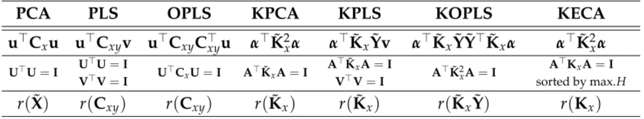
4.2 Comparison of supervised kernel feature extraction methods . . . 45
4.2.1 Feature extraction for classification . . . 45
4.2.2 Feature extraction for biophysical parameter estimation . . . 48
4.3 Invariant kernel feature extraction . . . 49
4.3.1 Virtual SVM . . . 50
4.3.2 Experimental results . . . 51
4.4 Extracted features from virtual samples . . . 57
4.5 Summary . . . 59
5 Advances in Unsupervised Kernel Feature Extraction 63 5.1 Introduction . . . 64
5.2 Optimized Kernel Entropy Component Analysis (OKECA) . . . 65
5.2.1 Proposed Optimized Kernel Entropy Components (OKECA) . . . 66
5.2.2 Experiments . . . 69
5.3 Probabilistic cluster kernel (PCK) . . . 76
5.3.1 Introduction to generative kernels . . . 76
5.3.2 Proposed Probabilistic Cluster Kernel (PCK) . . . 77
5.3.3 Experimental results . . . 79
6 Semisupervised Kernel Feature Extraction with Generative Cluster Kernels 87
6.1 Introduction to semisupervised learning . . . 88
6.1.1 Bagged kernel for support vector machine . . . 89
6.1.2 Multiscale bagged kernel support vector machine . . . 90
6.1.3 Proposed semisupervised kernel feature extraction . . . 90
6.2 Semisupervised Kernel Partial Least Squares (SS-KPLS) . . . 93
6.2.1 Semisupervised feature extraction for classification . . . 95
6.2.2 Semisupervised feature extraction for biophysical parameter retrieval . . 99
6.2.3 Analysis of the kernels . . . 103
6.3 Semisupervised Kernel Orthonormal Partial Least Squares (SS-KOPLS) . . . 103
6.3.1 SS-KOPLS for image classification . . . 104
6.3.2 SS-KOPLS for biophysical parameter retrieval . . . 107
6.3.3 Analysis of the kernels . . . 109
6.4 Summary . . . 110
7 Conclusion and Discussion 111 7.1 Achievements and relevance . . . 114
7.2 Visits to national and international research centers . . . 116
7.3 Acknowledgements . . . 116
A Linear Algebra Tools 117 A.1 Eigenvalue-vector decomposition . . . 117
A.2 Generalized eigenvalue problem . . . 117
A.3 Singular value decomposition . . . 118
A.4 Deflation . . . 119
Abstract in Spanish
Esta Tesis aborda el análisis de datos de teledetección empleando métodos de aprendizaje máquina. En particular, en este trabajo se proponen diferentes métodos kernel para la extrac-ción de características relevantes a partir de imágenes hiperspectrales adquiridas por satélites de observación de la Tierra. El gran volumen de datos adquiridos, debido a la cada vez mayor resolución tanto espacial y temporal como espectral de las imágenes, hace casi imprescindible el empleo de técnicas que permitan reducir la dimensionalidad de los datos manteniendo la información relevante. Por otro lado, la heterogeneidad y las relaciones no lineales presentes en este tipo de datos sugiere el uso de métodos avanzados no lineales que sean capaces de adaptarse a las particularidades y propiedades de estas imágenes. El fin último del análisis de las características extraídas es, en definitiva, el de interpretar la información contenida en los datos y extraer conocimiento. Si se consigue capturar la estructura subyacente en los datos correctamente, estas características pueden emplearse directamente en tareas generales como clasificación, regresión, segmentación, compresión, o visualización facilitando su uso y mejo-rando los resultados. En este contexto, esta Tesis presenta diferentes métodos núcleo (kernel) de extracción de características con dos objetivos principales: 1) incluir conocimiento a priori sobre el problema a resolver y 2) aprender la distribución de los datos disponibles.
Además, uno de los problemas en la mayoría de aplicaciones de teledetección es la dificultad para obtener muestras etiquetadas por lo que es pertinente el estudio de algoritmos super-visados, no supervisados y semisupervisados. Por tanto, las propuestas que se plantean en la presente Tesis son las siguientes. En los métodos supervisados, la calidad de los resultados de-pende de las muestras etiquetadas que en muchas ocasiones son escasas y no contemplan todos los escenarios posibles, lo cual puede afectar a la capacidad de generalización y robustez de los modelos. En estos casos, cuando se conoce el problema y frente a qué variables el modelo de-bería ser invariante, forzamos esa invarianza generando muestras de entrenamiento virtuales que incluyan esa información. En los métodos no supervisados, el número de muestras de las cuales se puede aprender no está limitado, pero al no disponer de muestras etiquetadas, la aproximación más usual para reducir la dimensionalidad de los datos es la de encontrar las proyecciones que preservan mejor la varianza de los datos. Sin embargo, cuando los datos no siguen una distribución Gaussiana, podemos usar otros criterios como la teoría de la
ción para encontrar las proyecciones que alternativamente maximicen la entropía.
Por otro lado, un problema común en los métodos no supervisados es que no se dispone de in-formación para ajustar los parámetros libres del modelo. Para aliviar este problema se propone un kernel generativo capaz de medir similitudes locales y globales al considerar diferentes agrupamientos a diferentes escalas, lo cual hace el modelo prácticamente independiente de ningún parámetro.
Por último, cuando se dispone de un número limitado de muestras etiquetadas, las caracterís-ticas extraídas pueden aprovechar la información contenida en las abundantes muestras sin etiquetar de la imagen analizada. Para ello, se propone un método semisupervisado que com-bina las similitudes del kernel supervisado y el kernel generativo aprendido a partir de todos los datos.
Los métodos de extracción de características propuestos se ilustran en bases de datos estándar e imágenes de teledetección de diferentes características. En general los resultados confirman, por un lado las hipótesis de partida mostrando una clara ventaja de los métodos kernel re-specto de las versiones lineales. Y por otro lado, los métodos propuestos que para cada uno de los posibles escenarios de aprendizaje resuelven o mitigan los problemas más frecuentes impuestos por datos de teledetección.
Abstract
This Thesis faces the challenging problem of remote sensing data analysis from a machine learning perspective. In particular, different kernel feature extraction methods are proposed to discover the most relevant features form multi and hyperspectral images acquired by Earth observation satellites. The huge data volume acquired by these sensors –basically due to the increasing spatial, temporal and spectral resolution of the images– makes almost mandatory using techniques that allow us to reduce the data dimensionality while keeping the relevant information. On the other hand, the heterogeneity and nonlinear relations present in this type of data suggests the use of advanced nonlinear methods adaptable to the particularities and properties of the images. The analysis of the extracted features is ultimately aimed at inter-preting the data information and knowledge discovery about the problem. If the underlying data structure is properly captured, these features can be directly used in general tasks such as classification, regression, clustering, compression or visualization, making easier the anal-ysis and improving the results. In this context, this Thesis presents different kernel feature extraction methods with two main objectives: 1) to include a priori knowledge about the prob-lem to be solved, and 2) to learn the data distribution from the available samples. In addi-tion, one of the problems in most remote sensing applications is the difficulty to obtain labeled samples, which makes also pertinent to study supervised, unsupervised and semisupervised approaches. Therefore, proposals in the present Thesis can be summarized as follows. In su-pervised methods, the quality of the results depends on the available labeled samples, which are usually scarce and do not cover all possible scenarios. This, in fact, may affect the general-ization capability and robustness of the models. Therefore, when one knows the problem and to which variables the model should be invariant, one can force this invariance by generating virtual training samples that encode this information. In the unsupervised methods, the num-ber of unlabeled samples used for learning is almost unlimited and, in the unsupervised feature extraction context, the most common approximation to reduce the dimensionality is based on preserving the variance of the data. However, when the data do not follow a Gaussian distribu-tion, one can resort to information theory concepts in order to find the projections maximizing entropy. On the other hand, a common problem of unsupervised methods is that there are no labeled samples to tune the free parameters of the models. In order to mitigate this problem,
a generative kernel based on the cluster assumption is proposed. The kernel captures local and global similarities in the data manifold by clustering the data at different scales, which makes the model almost independent of any parameter. Finally, when a limited number of la-beled samples is available, extracted features can also exploit the information contained in the wealth of unlabeled samples from the analyzed image. Therefore, a semisupervised method combining the similarities of the supervised kernel and the generative kernel learned from the whole dataset is proposed. The feature extraction methods proposed in this Thesis are illus-trated in standard machine learning problems and in a wide range of remote sensing images with different characteristics. The results confirm the hypotheses showing a clear advantage of kernel methods with respect to the linear versions. Moreover, results show how the proposed methods solve or mitigate the problems present in remote sensing data.
Preface
Context and overview
Earth observation by remote sensing is an interdisciplinary field of Science focused on moni-toring our planet using a wide range of instruments that capture information of the observed scenes at different electromagnetic wavelengths. Materials can be identified using the different interactions with the electromagnetic radiation emitted, absorbed and reflected by objects de-pending on their composition. The spectral information is also very useful to estimate relevant biophysical parameters characterizing the processes on Earth. Examples of remote sensing products and applications include land cover thematic maps, land use inventories, as well as temperature and chlorophyll content maps, just to name a few. Remote sensing actually in-volves a plethora of broader applications with great economical and societal values, such as urban monitoring, fire detection or flood damage evaluation among others. In all of them, analyzing the acquired images by the sensors efficiently is of paramount importance. In this context, Earth observation by remote sensing implies nowadays many different fields of Sci-ence and Engineering, such as signal and image processing, statistics, computer vision, and physics. All of them follow different approaches to tackle the same fundamental scientific chal-lenge: extracting useful information from the acquired images.
Before answering the question of how to extract the useful information from images, one should question what makes optical remote sensing images so distinctive. Statistically, multi and hyperspectral images are not very different from natural grayscale and colour photo-graphic images. Grayscale images are spatially smooth: the joint probability density function (pdf) of the luminance samples is highly nonuniform, the covariance matrix is highly non-diagonal, the autocorrelation functions are broad and have generally a 1/f band-limited spec-trum. In the case of color images, the correlation between the tristimulus values of the natural colours is typically high. Despite all these commonalities, the analysis of multi- and hyper-spectral images turns out to be more difficult, especially because of the high dimensionality of the pixels and the spatial-spectral patches, the high spatial and spectral redundancy, the particular noise sources present in the acquired data, the typically non-Gaussian nature of the data, and perhaps more importantly their potential nonlinear nature. Such nonlinearities can
be related to a plethora of factors, including the multi-scattering in the acquisition process, the heterogeneity at subpixel level, as well as the impact of atmospheric and geometric distortions. The imaging process may lead to non-Gaussian pixel distributions, as well as pixels typically embedded on distinct nonlinear manifolds within the higher-dimensional feature spaces. The high spectral sampling of hyperspectral images, for instance also leads to strong collinearity issues. Finally, the spatial variability of the spectral signature increases the internal class vari-ability. All these factors, in conjunction to the few labeled examples typically available, make information extraction a very challenging problem. As a result, the accuracy obtained with standard parametric models, either for data classification, regression orpdfestimation, is very often compromised.
The problems raised by the high dimensionality of the data and the high spectral and spatial collinearity are commonly referred to as theHughes phenomenonin the remote sensing commu-nity. This problem is known as thecurse of dimensionalityin the machine learning community. The problem is ubiquitous in remote sensing data processing. Inference in high-dimensional low-sized datasets turns to be very challenging because the lack of samples to properly cover the space volume increased by dimensionality. There are two obvious solutions to this situa-tion: either increase the number of samples or to reduce the data dimensionality. On the one hand, increasing the number of labeled samples is aimed to obtain a statistically more robust and reliable representation. Nevertheless, to achieve this objective, the number of samples has to increase exponentially with the dimensionality, which is not easy in remote sensing given the high cost associated to data labelling. On the other hand, reducing the dimensionality of the data can be done either through feature selection or feature extraction approaches. Feature se-lection, or variable sese-lection, tries to select a subset of relevant input features (or variables) that optimally summarize the data information. The main advantage is that the retained features keep their meaning and units, but these approaches may be hampered by strong nonlinear fea-ture relations and scarcity of labeled samples to guide the optimization criterion. Alternatively, one can resort tofeature extractiontechniques, which aim to find a transformation of the data to a lower dimensional space while retaining most of the information content. The obtained features are combinations ofall the original input features, so in principle they can be more appropriate to deal with complex feature relations.
Motivation and Objectives
This Thesis will investigate the recurrent problem in remote sensing data processing of deal-ing with high dimensional low-sized datasets. The previous alternatives to solve the problem will be investigated. On the one hand, we will focus on methods that can incorporate poten-tially informative samples without additional sampling: we will exploitprior knowledgeabout the problem and the expected feature relations to include synthetic examples, and we will ex-ploit the information contained in the wealth of unlabeled examples present in the scene to better model the data distributions. On the other hand, we will concentrate on reducing data
dimensionality via feature extraction in order to obtain potentially useful data representations. In both approaches we will have to deal with nonlinear feature relations and non-Gaussian scenarios. Therefore, we will consider nonlinear inference functions for the task at hand. The general aim is then learning a function f(·)that, departing from input sensory datax∈ X can predict an output target variable y ∈ Y. The problem can be approached directly with non-linear models implementing f(·), e.g. with neural networks or kernel machines. Despite its efficiency, this approach leads to hidden representations that are hard to analyze and visualize. Alternatively, one can approach the problem by learning an intermediate transformation g(·) from the original, potentially high-dimensional feature spaceX, to an accessible representation space of fewer dimensions,R. Then one can use the data projected intoRto perform a simple linear transform, h(·), to infer the output variable. This approach delivers two important ad-vantages: 1) the first nonlinear step leads to an accessible feature space of lower dimensionality, and 2) the second linear step typically involve solving simpler, faster and convex optimization problems. The Thesis will focus on this second approximation, and in particular will design kernel methods to learn the nonlinear feature extraction transformation.
(a) Nonlinear f(·)
X Y
(b) Nonlinearg(·) Linearh(·)
X R Y
This Thesis is aimed to support the scientific and technological interest in kernel feature extrac-tion for remote sensing data analysis. Two major points motivate the combinaextrac-tion of feature extraction methods with kernel methods. On the one hand, feature extraction methods reduce the dimensionality of data looking for data projections that better describe the data. On the other hand, kernel methods implicitly transform the original data to a feature space in which the nonlinear relations are likely to be reduced. The data projected into the most relevant fea-tures therein may be more useful than in the original input space because they account for nonlinearities and non-Gaussian distributions efficiently.
The Thesis in a nutshell
• What is the main goal? To develop algorithms for dimensionality reduction better adapted to the statistical characteristics of remote sensing data: high dimensionality, low number of labeled samples, nonlinear feature relations and non-Gaussian distributions.
• Why is the topic important?the goal is important and timely given the increasing num-ber of heterogeneous satellite images acquired by current and upcoming satellite con-stellations. Reducing the data dimensionality while keeping the information content is a relevant research and a technological opportunity. The goal is also challenging method-ologically as it implies developing new machine learning methods adapted to specific data characteristics.
• How do we plan to address it?Kernel methods provide a solid mathematical framework to tackle nonlinear dimensionality reduction. Kernel machines also allow us to design nonlinear algorithms easily, and are able to incorporatepriorknowledge, invariances and regularization terms. All these ingredients are aimed to generate data representations with high expressive power, i.e. compact and informative.
Research objectives
The present Thesis contributes with kernel feature extraction developments to deal with remote sensing data. We will develop methods that can cope with nonlinearities and non-Gaussian data distributions, as well as with methods that deal with few labeled samples, incorporate prior knowledge and invariances through regularization. These objectives will be guided by the following research questions:
• On the remote sensing data manifold characteristics.
1. Can kernel methods cope with global and local manifold structure? Kernel methods can capture nonlinear feature relations efficiently. Typically they rely on a kernel func-tion that reflectsglobaldata similarities. However, localrelations can play a funda-mental role in the feature extraction, especially since uneven sampling is a common place in remote sensing datasets. By designing kernel functions that account forlocal relations in the manifold we aim to answer about how much local relations can be learned, what are the extent of such relations, and in what cases local information is more useful than global information. The problem is even more challenging in un-supervised scenarios because kernel parameters must be inferred without supervi-sion. We will investigate these issues under the learning paradigms ofsemisupervised learningin general andgenerative kernelsin particular.
2. Should kernel feature extraction be guided by maximizing the variance or entropy compo-nents? As we will see, all kernel feature extraction methods derive projections that optimize a particular criterion in feature spaces, either the variance of the projec-tions, the correlation or alignment with the labels. The latter methods cannot be obviously applied in unsupervised settings. Therefore, we will investigate alterna-tive measures to variance compaction in feature spaces. In particular we will focus onentropyas a measure of information content of the data. We aim to answer when and in what situations seeking for maximum entropy kernel components is more appropriate than seeking for maximum kernel variance components. These funda-mental question is aimed to study the Gaussian nature of the remote sensing data, as for Gaussian distributions variance and entropy are equivalent.
• On the inclusion of prior knowledge.
1. Can virtual data help feature extraction in supervised settings?Supervised feature extrac-tion methods applied to image analysis may need a large amount of labeled samples to yield efficient and effective representation spaces due to the curse of dimension-ality. This problem can be solved by increasing the number of labeled samples per dimension but this is very costly and time-demanding (human and computation-ally). An alternative could be to generate virtual samples from the original training data to fill in the space. Including informative samples is related toencode invariances in the extraction, as one can generate synthetic samples that reinforce the prior belief of feature relations based on solid physical knowledge about the problem. In turn, encoding invariances in a learning machine is a clear form of regularization since, roughly speaking, one tries to impose smoothness on the most plausible class of functions.
2. Can unlabeled data help feature extraction in semisupervised settings? Semisupervised learning has the advantage of accounting for both labeled samples and the infor-mation in the unsupervised data. In remote sensing data problems, e.g. image seg-mentation or biophysical parameter retrieval, this is a common situation. Departing from the previous generative kernels, we aim to investigate whether inclusion of both labeled and unlabeled samples offer a more accurate description of the remote sensing data manifolds, what is the information content of each counterpart, and in what situations the combination is beneficial.
These research questions and objectives have led us to develop a set of new kernel methods in supervised, unsupervised and semisupervised settings. Methods performance will be exam-ined in illustrative bidimensional toy examples, on classical machine learning databases, and on remote sensing problems (image segmentation and biophysical parameter estimation) with images of different spatial and spectral resolutions.
Organization
This Thesis is organized in seven chapters covering an introduction to remote sensing, a review of the background of kernel methods and multivariate analysis, the proposed supervised, un-supervised and semiun-supervised methods, and a discussion and conclusions obtained from the work. The outline is summarized as follows:
Chapter 1reviews the fundamental basis of optical remote sensing data processing, sum-marizes the main concepts involved in Earth observation and remote sensing imaging, and details the main problems in a classical processing chain.
Chapter 2reviews the fundamentals ofkernel methods, which is the used statistical learn-ing framework in the Thesis to classify images, estimate biophysical parameters, cluster data and to validate all the proposed algorithms.
Chapter 3reviews the framework of multivariate analysis to extract linear and nonlinear features, along with a compilation of state-of-art feature extraction methods applied to remote sensing data.
Chapter 4 addresses the study of encodinginvariances via data synthesis, as well as it analyzes the impact of these samples on supervised nonlinear feature extraction methods. Furthermore, the chapter introduces the virtual support vector machine (VSM) in remote sensing field.
Chapter 5addresses two unsupervised nonlinear feature extraction methods based on kernels. The first one proposes an optimization of the kernel decomposition based on Kernel Entropy Component Analysis (KECA). The second method is the Probabilistic Cluster Kernel (PCK), a free-parameter generative kernel learned from data that captures the local and global data manifold structure.
Chapter 6addresses the semisupervised kernel feature extraction problem. The chapter reviews the state-of-art in semisupervised learning and explains the proposed method: SemiSupervised Kernel Partial Least Square (SS-KPLS) and its orthonormalized exten-sion, the SemiSupervised Orthonormalized Kernel Partial Least Square (SS-KOPLS). Both proposals exploit the unlabeled information of the data along with the supervised infor-mation.
Chapter 7summarizes the accomplished objectives and discusses the main conclusions obtained throughout this work.
Appendix Apresents the linear algebra tools and the main matrix factorization funda-mentals.
Chapter
1
Introduction to remote sensing data
processing
Contents
1.1 Introduction to remote sensing . . . . 2 1.2 Standard techniques for remote sensing image processing . . . . 4
1.2.1 Remote sensing image transmission and coding . . . 4
1.2.2 Remote sensing image preprocessing tasks . . . 5
1.2.3 Remote sensing image processing tasks . . . 6
1.3 Advanced machine learning for remote sensing data processing . . . . 8
1.3.1 Manifold Learning . . . 8
1.3.2 Semisupervised Learning . . . 9
1.3.3 Transfer Learning . . . 9
1.4 Summary . . . . 10 Earth observation through the analysis of remote sensing data has contributed with real-life applications with great societal benefits. For instance urban monitoring, fire detection or flood prediction from remotely sensed multispectral or radar images have a great impact on eco-nomical and environmental issues. To treat efficiently the acquired data and provide accurate products, remote sensing has evolved into a multidisciplinary field, where machine learning and signal processing algorithms play an important role nowadays (Tuia and Camps-Valls, 2009a; Camps-Valls, 2009). All the applications, from a machine learning and signal/image processing perspective, are tackled under specific formalisms, such as classification and clus-tering, regression and model inversion, image coding, restoration and enhancement, source unmixing, data fusion or feature selection and extraction. In general, statistical machine learn-ing has proven successful in many disciplines of Science and Engineerlearn-ing (Hastie et al., 2009). Machine learning is a multidisciplinary field used in several domains such as computer sci-ence, signal and image processing, computer vision, etc. In the last decade, machine learning
has found widespread adoption in remote sensing and geosciences as well. Nowadays, for instance, statistical inference algorithms are regularly used for image classification, target de-tection and biophysical parameter retrieval applications, just to name a few (Camps-Valls et al., 2011).
In this chapter, a brief introduction to remote sensing is first given. The electromagnetic ra-diance, the kind of sensors and their different resolutions are described to frame the Thesis. The standard remote sensing data processing chain that goes from the signal acquisition to the final product is then detailed. Finally, new trends in machine learning for remote sensing data processing are commented.
1.1
Introduction to remote sensing
Earth observation is a multi-disciplinary field embracing physics, chemistry, electronic, cartog-raphy, geology, forestry and computer science, among others. Earth observation via remote sensing data analysis aims to study the Earth’s surface (and interactions with the atmosphere) as a complex, evolving system. The information captured using different remote sensing imag-ing sensors is relevant: they essentially measure the electromagnetic radiation reflected, ab-sorbed, and emitted in a different way by materials in a scene depending of their molecular composition and shape. Such acquired signals help monitoring the processes occurring on Earth, and lately thanks to new satellite sensors this can be done with unprecedented accuracy. The Electromagnetic (EM) Radiation changes according to the wavelength. The energy distri-bution of all electromagnetic waves is known aselectromagnetic spectrum. The electromagnetic spectrum covers regions from short to long wavelengths: Gamma-Rays, X-Rays, Ultra-Violet (UV), Visible, Infrared, Microwaves and Radio waves:
• Gamma-Rays and X-Rays are highly energetic waves that are absorbed by the higher layers of the atmosphere, and thus are not favorable for Earth observation.
• Ultra-Violet are also used in studies about surface of planets with and without atmo-sphere.
• Visible is the most widely used range in Remote Sensing together with the Infrared re-gion. The Visible region covers a narrow interval (0.4 to 0.7µm) of the EM spectrum where we can find Red (0.6−0.7µm), Green (0.5−0.6µm) and Blue (0.4−0.5µm) bands (RGB) that human visual system is adapted to.
• Infrared (IR) can be divided in three ranges: Near, Medium and Far Infrared. The two first intervals are close to the visible region, and along with it, are the most used by spec-trometers, radiometers, polarimeters and lasers. The far IR is referred to as the emitted infrared or “thermal energy” considering that the radiation on this interval is directly related to the body’s heat.
• The Microwave range is used in microwave radiometers and radar systems, such as the Synthetic Aperture Radar (SAR) imaging systems.
• The last region of theelectromagnetic spectrumcorresponds to the Radio waves, which is used by active sensors like radio altimeters.
Remote sensing exploits theradiation-matter iterationand deals with the acquisition of informa-tion about a scene (or specific object) at a short, medium or long distance. According to the type of energy sources involved in the data acquisition, remote sensing imaging instruments can bepassiveoractive:
• Passive systems: These are sensors that rely on solar radiation as the source of illumina-tion. Some examples of passive sensors are multi- and hyperspectral imaging sensors.
• Active systems: These are sensors that accomplish a dual function, that is, to produce a signal and to register it after interacting with the observed system. Radar systems or Laser Imaging Detection and Ranging (LIDAR) are examples of systems for active remote sensing.
This thesis concentrates on passive systems for Earth monitoring. Passive systems usually ex-ploit solar radiation to capture the reflected radiation, which is acquired by airborne or satellite spectrometers at different wavelengths. The quality of the information collected is based on theresolutionof the sensors. Higher resolution means more information taken from the scene, but it involves greater information storage. There exist different types of resolution in a remote sensing image:
1. Radiometric resolution is the number of gray levels in which the radiation is divided for storage. The gray level is a numeric value that represents the radiance captured by the sensor.
2. Temporal resolution is related to the revisit time of the remote sensing platform.
3. Spatial resolution is the surface’s distance between image elementsorpixels. The spatial resolution not only depends on the type of sensor, but also on the altitude and angle from which the scene is captured.
4. Spectral resolution is related to the number and separation of spectral channels (or bands) recorded by the sensor.
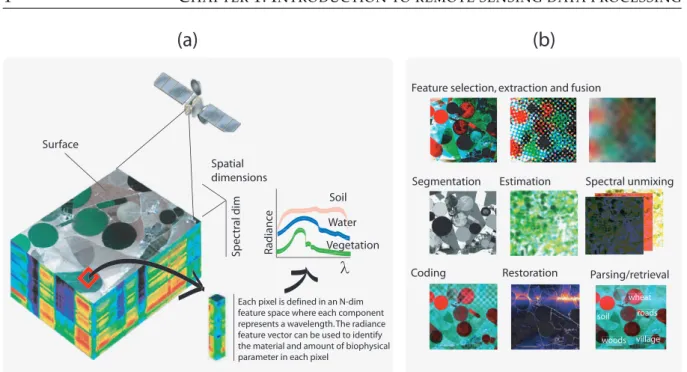
In this Thesis, we will focus on optical images only. Figure 1.1(a) shows the basic principle of imaging spectroscopy to perform satellite remote sensing. Image pixels are linked to two spa-tial coordinates that, together with the spectral (wavelength) dimension, form a “hypercube” or data cube (Shaw and Manolakis, 2002; Lillesand et al., 2008). Hence, a pixel is a vector where each dimension informs about the radiance captured by the sensor at the different wavelengths. Each pixel in the scene has its own spectrum orspectral signature, which can be used to identify and classify the object into different thematic classes automatically.
(a)
(b)
Surface Spatial dimensions Sp e ct ral dim Soil Water Water Water Water λEach pixel is defined in an N-dim feature space where each component represents a wavelength. The radiance feature vector can be used to identify the material and amount of biophysical parameter in each pixel
Feature selection, extraction and fusion
Segmentation Estimation Spectral unmixing
Coding Restoration Parsing/retrieval
Figure 1.1: The concept of imaging spectroscopy. Airborne/Spaceborne imagery is acquired,
com-pressed, preprocessed and analyzed. The latter step includes classification for mapping
applica-tions, regression for biophysical parameter estimation, anomaly detection and target recognition. Source: Camps-Valls (2009).
1.2
Standard techniques for remote sensing image processing
Remote sensing image processing departs from the acquired hypercube and applies a set of techniques and methods that allow capturing information from the observed scene. The main objective is to provide a ready-to-use product to the users that is obtained from the acquired im-age. Figure 1.1(b) shows some of the main problems involved in remote sensing image process-ing, including the data storage/coding and transmission, pre-processing (e.g. feature selection and extraction), and processing (e.g. segmentation, unmixing). The final aim of this Thesis is to developfeature extraction methodsfor land cover classification and bio-geo-physical parameter retrieval, which is a critical step before the classification or regression steps, respectively. The main stages in the remote sensing image processing chain are detailed in what follows.
1.2.1 Remote sensing image transmission and coding
Along with the increasing demand of hyperspectral data, the sensor technology used to capture remote sensing images has been significantly developed in the last decade, improving, among others, the spatial and spectral resolutions. Such improvements on quality leads to an increas-ing demand on storage and bandwidth transmission capabilities. Both lossy and lossless image coding have been investigated extensively for multispectral imagery, but more important for hyperspectral images (García-Vílchez et al., 2011). The current recommendation are based on a transform stage, where data is decorrelated in the spatial domain using a wavelet transform
(plus a bit plane encoder stage), thus following the latest standard JPEG2000 for grayscale im-ages. Other well-known wavelet-based coding systems are SPIHT-3D and SPECK-3D (Karami et al., 2012). In order to improve the coding performance, a common strategy is to decorrelate first the image in the spectral domain (Keerthana and Sivasankar, 2013).
1.2.2 Remote sensing image preprocessing tasks
From all the possible preprocessing steps aimed at improving the image and product qual-ity, three steps are intimately related to the objectives of this Thesis: image restoration, feature extraction/selectionandimage fusion.
Image restoration
Image restoration is an important step in the remote sensing image processing chain since it is intended to correct the distortions affecting the image formation. Several corrections are typically applied:
• Radiometric correctiondeals with the corrections of the observed values that are usually related to the imaging sensor and the data acquisition and transmission, such as missing pixels or lines of an image (Yan and Shaker, 2014).
• Atmospheric correction is the process of correcting the distortions in the radiance values observed at the sensor level caused by the atmosphere (Fuyi et al., 2013).
• Topographic correctionis the process of correcting terrain effects, mainly due to the surface elevation and observation/illumination geometries (Schlapfer et al., 2012).
• Geometric correctionis the process where the geometry of the image is corrected to provide an exact location to the image pixels in a specific surface projection (Hu and Tang, 2011). In addition to the previous distortions, different noise amounts and sources are present in re-mote sensing data. To mitigate the noise problem, the most common way in hyperspectral images is by means of PCA (Chen and Qian, 2009). Nevertheless, an alternative is the widely used minimum noise fraction (MNF) algorithm (Green et al., 1988) and its recent nonlinear version (Gómez-Chova et al., 2011). Furthermore, the noise covariance estimation is a more challenging problem and other techniques have been recently proposed, such as anisotropic diffusion (Mendez-Rial and Martín-Herrero, 2012), wavelet shrinkage (Chen and Qian, 2011), or kernel multivariate methods (Camps-Valls and Bruzzone, 2009).
Feature selection and extraction
The high collinearity between spectral bands pose a challenging problem when working with hyperspectral images. Essentially, machine learning algorithms suffer from a risk of overfitting thus giving rise to poor generalization capabilities. In these situations, feature selection and
extraction are central tasks because of thecurse of dimensionality(Guyon et al., 2006). Standard feature selection methods select features that minimize a given criterion, e.g. the classification error, by means offilter methods. This approach typically rely on correlation or the mutual in-formation between the bands and the class labels to discard irrelevant or redundant channels. The approach has been extensively studied in remote sensing data processing (Pal and Foody, 2010). Recent advances focus onwrapper methods, which select features that minimize the clas-sification error directly (Bolón-Canedo et al., 2013). This approaches are typically greedy and thus computationally expensive.
Feature extraction pursue a different direction: roughly speaking, all input variables are used and combined to derive a reduced set of new features that maximally preserve the information content of the original data. The most common method is linear PCA but recent advances have been proposed using nonlinear methods such as locally linear embedding or isometric map-ping (Jia et al., 2013). In the last years, multivariate kernel-based feature extraction methods have been proposed to address nonlinearities in the data (Arenas-García et al., 2013). In all these methods, one can also usespectral and spatial filters to extract edges or geometrical fea-tures (Richards and Jia, 1999) although one typically exploitmorphological operationsto further improve object detection (Izquierdo-Verdiguier et al., 2011). This thesis will concentrate on multivariate kernel-based algorithms for feature extraction.
Remote sensing image fusion
As we have seen in section 1.1, there are different sensor resolutions: spectral, spatial and temporal. Spatial resolution of sensors is often limited with respect to their spatial resolution. Panchromatic sensors provide high spatial resolution whereas multispectral or hyperspectral sensors give a high spectral resolution with low spatial detail. Sensors with both high spec-tral and spatial resolutions would be technology challenging and extraordinarily expensive, if at all physically realizable. An alternative comes from the field of imaging processing: image fusion methods are used to generate an image with both (good spatial, good spectral) charac-teristics. There are specific approaches developed for remote sensing image processing based on wavelets (N. Indhumadhi, 2011) or for multisource fusion such as Ehlers et al. (2010) that combines SAR with optical panchromatic images.
1.2.3 Remote sensing image processing tasks
The last step of the remote sensing image processing chain is intended to provide products obtained from the remote sensing images that can be directly used or interpreted by the final users. There are many products worth mentioning: abundance maps of materials of interest, land cover and land use maps that allow monitoring, estimated biophysical parameter maps that permit phenology studies, saliency maps that highlight interesting portions of the scene, etc. The most relevant remote sensing problems analyzed in this Thesis are land cover clas-sification and biophysical parameter retrieval only. They are typically tackled by particular
classification and regression algorithms, respectively. We will instead focus on learning non-linear feature transforms that lead to rich data representations where soimple (ideally non-linear) classification or regression should suffice. In the following sections, we review applications in these two fields.
Biophysical parameter retrieval and model inversion
The estimation of biophysical parameters represents a paramount scientific challenge in re-mote sensing in order to better understand the environment dynamics at local and global scales (Lillesand et al., 2008). The inversion of analytical models introduces a high level of complex-ity and computational burden, and sensitivcomplex-ity to noise becomes an important issue. As a direct consequence, the use ofempirical modelsadjusted to learn the relationship between the acquired spectra and the actual ground measurements has become very attractive in recent years. Para-metricmodels have some important drawbacks, which typically lead to poor prediction results on unseen (test) data. As a consequence, non-parametric and potentially nonlinearregression techniques have been effectively introduced for the estimation of biophysical parameters from remotely sensed images. Different models and architectures of neural networks have been con-sidered for the estimation of biophysical parameters (Vilas et al., 2011). Recently the use of support vector regression (SVR) and other Bayesian nonparametric methods have been pre-sented as efficient alternatives to neural networks for modeling some biophysical parameters (Verrelst et al., 2012b). We will further review the emerging field of kernel machines for bio-physical parameter retrieval in the next chapter.
Image classification
A relevant application in remote sensing is to create classification maps for urban monitoring, catastrophe assessment, change or target detection. Depending on the available data, it is possi-ble to divide classification methods in three main families: i)supervised methods, ii)unsupervised methodsand iii) semisupervised methods. Supervised methods are probably the most common in remote sensing, and neural networks (Pacifici and Del Frate, 2010) and support vector ma-chines (Mountrakis et al., 2011) are popular algorithms. The latter method has been applied in several problems for urban monitoring (Schwert et al., 2013) or multi-temporal classification (Niu and Ban, 2013), among others. Unsupervised methods rely on clustering image pixels de-pending on their similarity. Finally, semisupervised methods involve combining both labeled and unlabeled data in the same model. These methods exploit the information conveyed by abundant unlabeled data to generate, for example, improved land cover maps (Muñoz Marí et al., 2012; Kiyasu et al., 2011).
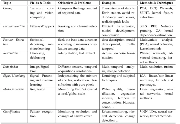
Table 1.1 summarizes each step of the processing chain in remote sensing. We include the main steps, the fields of engineering and sciences involved, the learning paradigms applicable, a brief summary of the objectives, examples of applications and the main current methods and techniques used in each of them. The summary does not pretend to be exhaustive but to serve
Table 1.1:A taxonomy for remote sensing methods and applications, based on (Tuia and Camps-Valls, 2009a).
Topic Fields & Tools Objectives & Problems Examples Methods & Techniques
Coding Transform
cod-ing and vision computing
Compress the huge amount of acquired data
Transmission of data to Earth station, avoid re-dundancy and errors, realistic quick-looks
PCA, DCT, Wavelets, SPIHT, kernel feature extraction
Feature Selection Filters/Wrappers Ranking and channel selec-tion
Efficient transmission, model development, compression.
SFFS, RFE, Network pruning, GA, kernel dependence estimation Feature Extrac-tion Statistical, denoising, ma-chine learning
Seek the best data direction according to measures of re-lations among data
data description, model development, multi-temporal
Multivariate analysis (PCA), neural networks, kernel methods Restoration Denoising,
deblurring
interpretation, feat. extract. Acquisition noise, trans-mission
Wiener, wavelets, ad-vanced denoising, ker-nel methods
Data fusion Image/Signal Proc.
Different sensors, temporal acquisitions, resolutions
Multi-temporal analy-sis, change detection
Multi-resolution, fusion Signal Unmixing Signal
Process-ing and machine learning
Independizing the mixture of spectra, restoration, clas-sification with pure pixels
Unmixing and subpixel techniques
ICA, linear/non-linear unmixing, kernels and pre-images.
Model inversion Regression Monitoring Earth’s Cover at a local/global scale
Water quality, deser-tification, vegetation indexes, temperature concentration , biomass, ozone, ...
Linear regression, neu-ral networks, kernel methods.
Classification Pattern recogni-tion
Monitoring evolution and changes of Earth’s cover
Urban monitoring, min-eral detection, change detection, ...
k-NN, LDA, neural net-works, kernel methods
as a comprehensive summarizing view of the field.
1.3
Advanced machine learning for remote sensing data processing
As we have already motivated before, the high dimensionality of the data, the high spectral and spatial collinearity, or the few labeled examples motivates the use of machine learning techniques in remote sensing data processing. Regularization of the models or semisupervised learning are techniques that allow introducing additional information to prevent overfitting or to solve an ill-posed problem. In this section, we summarize some recent learning paradigms and the main techniques applied in remote sensing that are related to the core of the Thesis.
1.3.1 Manifold Learning
Manifold learning considers that high dimensional data can be mapped to a lower dimen-sional space without information loss of the original data. This recent field is closely related to dimensionality reduction and nonlinear feature extraction. The manifold learning framework embraces a large set of algorithms. In order to circumvent the problems associated to
tradi-tional linear dimensionality reduction methods, many algorithms have been proposed in the machine learning community, such as spectral, graph-based, neural networks, principal curves and projection pursuit methods. They are however seldom used in remote sensing problems. Among them, the most common algorithms applied to remote sensing are Local Linear Embed-ding (Crawford et al., 2011), Isomap (Feilhauer et al., 2011) and Lapacian eigenmaps methods (Shi et al., 2013). Lately, as will be discussed in upcoming chapters, the family of kernel meth-ods have been exploited to tackle manifold learning problems (Arenas-García et al., 2013). 1.3.2 Semisupervised Learning
Regularization is a way to introduce more information than the available in the data to reduce the complexity of the models. A specific way of regularization is by means of semisupervised learning. The main idea is to develop the model not only with the supervised information but also adding the information of unlabeled data in order to improve the supervised model. These methods can be divided ingenerative, which are based on probabilistic models, ordiscriminative, which directly learn class boundaries. In remote sensing, generative models have been applied in segmentation tasks (Li et al., 2010), urban monitoring (Tuia and Camps-Valls, 2011), or pixel based classification (Maulik and Chakraborty, 2012). Furthermore, it is possible to model the data representation by cluster kernels (Gómez-Chova et al., 2010) or graphs applied in tar-get detection, regression, and classification (Camps-Valls et al., 2014). Other semisupervised approaches are the transductive SVM (Bruzzone and Demir, 2014) and transductive Multiple-Kernel Learning (Sun et al., 2014), which have been applied in image classification. The field of semisupervised learning is tightly related to the previous manifold learning paradigm, since the aim is to learn or encode the information of the manifold structure by exploiting all avail-able data.
1.3.3 Transfer Learning
Finally, it is worth mentioning the field of transfer learning, that aims at transferring knowl-edge (or a model) trained or adjusted in one (source) domain to another (target) domain. This is an ubiquitous problem in remote sensing data processing. For example, land-cover maps are only updated by classifying image time series when training samples collected at a particular time are available, which commonly requires re-training classifiers. Transfer learning would avoid that by updating the classifier or the data representation. The field of transfer learning is also known asdomain adaptation. The problem was initially tackled with partially unsuper-vised classifiers, under parametric formalisms and neural networks. The approach was then successfully extended to the use of SVM (Bruzzone and Marconcini, 2009). A related problem is also that of classifying an image with samples from different images, which induces the sam-ple selection bias or covariate shift problems. These problems have been recently presented by defining proper kernel machines (Gómez Chova et al., 2008). The field is also related to the general problem of learning and inference in manifolds.
1.4
Summary
This Chapter has briefly introduced remote sensing data processing to the reader. The elec-tromagnetic spectrum, the active and passive sensors, different image resolutions and the re-sulting data have been described. In addition, from the data acquisition to the product gen-eration, we have seen the most common processing problems. After imaging and acquisition, remote sensing needs to be stored and transmitted, and hence advances in image coding come to place. We have also introduced the three main pre-processing steps from an image pro-cessing perspective: image denoising, fusion and selection and feature extraction. The latter field of feature extraction will be analyzed in depth in the next chapters since it is the core of this Thesis. The last image processing step has briefly reviewed the main algorithms used to generate land-cover maps and biophysical parameter maps. The last part of the chapter has summarized some machine learning paradigms that provided the basis to develop the tools and algorithms proposed in this Thesis.
Chapter
2
Introduction to Kernel Methods
Contents2.1 Kernel methods in remote sensing . . . . 12 2.2 Introduction to kernel methods . . . . 14
2.2.1 Measuring similarity with kernels . . . 14
2.2.2 Positive definite kernels . . . 16
2.2.3 Basic operations with kernels . . . 16
2.2.4 Standard kernels . . . 18
2.2.5 Kernel development . . . 18
2.3 Examples of kernel methods . . . . 19
2.3.1 Support Vector Machine (SVM) . . . 20
2.3.2 Kernel Fisher’s Discriminant (KFD) . . . 21
2.3.3 Kernelk-means . . . 23
2.3.4 Hilbert-Schmidt Independence Criterion (HSIC) . . . 23
2.3.5 Kernel Density Estimation (KDE) . . . 24
2.3.6 Kernel bandwidth selection . . . 25
2.4 Summary . . . . 26
This chapter provides a summary of applications and recent theoretical developments of kernel methods in remote sensing data analysis. Section 2.1 summarizes the use of kernel methods in remote sensing and reviews the main applications. Section 2.2 presents a brief introduction to kernel methods, fixes notation, and reviews their basic properties. Section 2.3 reviews the classification setting, under paradigms of supervised, and unsupervised classification. Fur-thermore, the section presents kernel methods for density estimation and regression settings. We intentionally leave the treatment of kernel feature extraction for the next chapter, as it is the core of the Thesis. For more information about kernel algorithms see (Shawe-Taylor and Cristianini, 2004), (Schölkopf and Smola, 2002) and (Camps-Valls and Bruzzone, 2009).
The chapter is partly based on the paper:
E. Izquierdo-Verdiguier, L. Gómez-Chova and G. Camps-Valls, “Kernels for remote sensing image classification,”Wiley Encyclopedia of EEE (Submitted by invitation, expected publication 2015).
2.1
Kernel methods in remote sensing
Kernel methods are a standard tool in machine learning and pattern recognition, and are very suitable for remote sensing data processing (Camps-Valls and Bruzzone, 2009). Actually, in the last decade, kernel methods have been widely used in remote sensing data processing. This is mainly due to the fact that they fit the needs of the field, and can efficiently cope with the problems posed in many remote sensing data analysis. In particular, kernel methods are a solid mathematical framework to develop nonlinear algorithms that are easy to parametrize, fast and intuitive, and are typically robust to high dimensional data and problems with low number of labeled samples, which is often the case in Earth observation applications. Further-more, it is possible to combine multi-source heterogeneous data (i.e. images) by means of the use of particular compositions of kernels dedicated to process the spatial, spectral or temporal information (Camps-Valls et al., 2006b).
The information of the images acquired by imaging systems allow the characterization, iden-tification, and classification of the land covers present in the scenes (Richards and Jia, 1999). However, the high input data dimensionality in, for example, hyperspectral images degrade the performance of traditional classifiers such as artificial neural networks or Gaussian maxi-mum likelihood. These methods are highly impacted by datasets with low ratios of samples per number of dimensions, essentially because either they estimate poorly the parameters in the presence of noise or data sampling hampers the challenging problem of density estimation they aim to solve. The issue of low number of samples per dimension is known in the literature as thecurse of dimensionalityand has been largely reported in remote sensing image classifica-tion problems (Hughes, 1968; Fukunaga and Hayes, 1989). In such situaclassifica-tions, one is forced to impose some constraints on the solution, by mainly restricting thecapacity (i.e. flexibility, number of parameters) of the model to enforce simpler decision functions. This has been ap-proached by pruning weights in neural nets, enforcing sparsity in regression models, including informative features, and encoding invariances in the model. All of these approaches can be casted as different forms ofregularization.
In the last decades, the use of support vector machines (SVM) widespread in many fields of engineering and science (Shawe-Taylor and Cristianini, 2004; Schölkopf and Smola, 2002). The field of remote sensing has witnessed a similar wide adoption of SVMs, especially to tackle im-age classification problems (Camps-Valls and Bruzzone, 2009). The SVM has integrated three main processes in the same single algorithm. First of all, SVM makes afeature extractionstep
since data are mapped to a higher dimensional space in which they are classified with a simple (linear) algorithm. Second, in SVM, it is possible to control the complexity of the model by means of an efficient regularization procedure. And finally, an upper bound of the generaliza-tion error is minimized, thus the SVM follows the Structural Risk Minimizageneraliza-tion (SRM) princi-ple (Vapnik, 1998), which not only focuses on minimizing the training error but also limiting the capacity of the classifier. The application of SVMs has demonstrated very good performance in multispectral, hyperspectral, and multi-source image classification, see e.g. (Camps-Valls and Bruzzone, 2005; Camps-Valls et al., 2006b; Tarabalka et al., 2010; Tuia et al., 2011b,a; García et al., 2011). In this chapter, we will review the SVM formulation since this is the most widely used kernel method nowadays.
Another different concern in remote sensing problems is related to situations where the train-ing set is incomplete and/or not representative. We should stress that actually few attention has been paid to the case of having an incomplete knowledge of the classes present in the in-vestigated scene. Very often we find problems in which there is only one class of interest to be detected, e.g. in anomaly and change detection problems, urban monitoring, and cloud detection, just to name a few scenarios. In order to solve these types of problems, SVM has played an important role with extensions such as theone-class SVM, which only considers sam-ples belonging to the class of interest in order to learn the underlying data class support. The method was originally introduced for anomaly detection (Mercier and Girard-Ardhuin, 2006), then analyzed for dealing with incomplete and unreliable training data (Muñoz Marí et al., 2007), it has also been recently reformulated for change detection (Muñoz Marí et al., 2010), and recently was reformulated to introduce the user’s
Remote sensing image classification is restricted by both the quality and the number of labeled samples. This is due to the fact that acquiring ground truth information is very challenging and costly, mainly in complex and heterogeneous geographical areas. In order to alleviate this problem, the semisupervised learning (SSL) paradigm (Chapelle et al., 2006) introduced in ma-chine learning has been also exploited in remote sensing image classification. SSL employs the information contained in the abundant unlabeled samples along with the low number of la-beled samples. In several image classification applications, semisupervised learning has been applied ranging from: image segmentation (Mitra et al., 2004), image classification by means of semisupervised one-class SVM (Muñoz Marí et al., 2010), deformation kernels with the Lapla-cian SVM (Gómez-Chova et al., 2008) for cloud detection, transductive SVMs in remote sensing image classification (Chi and Bruzzone, 2005; Bruzzone et al., 2005, 2006), and semisupervised data mining applications (Vatsavai et al., 2005).
Kernel methods have also found application in regression and function approximation (Smola and Schölkopf, 2004), and also found application in some particular Earth observation appli-cations. Remote sensing very often deals with inverting a forward model or to approximate bio-geo-physical parameters from acquired imaging spectra. The goal is thus to obtain a robust model able to predict/estimate different parameters, such as temperature, vegetation variables like the fraction of vegetation cover (FVC) or leaf area index (LAI), water vapor, etc. While


![Figure 4.5: Kappa statistic κ (left) and SVs rate [%] (right) as a function of the number of training samples and window size w.](https://thumb-us.123doks.com/thumbv2/123dok_us/9959792.2488450/81.892.204.733.185.393/figure-kappa-statistic-function-number-training-samples-window.webp)
