City
ofWanneroo
Street Tree Master Plan
Version 2- September 2005Version No. Detail List of Revisions Date Authorised by
Version 1 - Aug’04 As Presented by Arbor Vitae and approved by Council
10 August
2004
Council Version 2 - Sept’05 Full Internal Review - As
adopted at City of Wanneroo Council Meeting held on 20 September 2005
• Addition of List of Common Names (Appendix C) • Addition of the following tree species:
1. Brachychiton gregorii
2. Callistemon “Kings Park Special” 3. Eucalyptus melliodora 4. Eucalyptus “torwood” 5. Liquidambar styraciflua 6. Melaleuca ericifolia 7. Prunus x blireana 8. Pyrus calleryana
Includes revisions to Landscape Character Unit Tree Lists and Appendix D (formerly Appendix C) Plant Information Fact Sheets.
• Modifications to Plant Information Fact Sheets including additional photos, more information on longevity, and amendments to the following: Olea europea (more information), correction of all “Headings” formerly spelt “Habitat” to “Habit” and spelling correction to Araucaria heterophylla. • Reference to “City of Wanneroo Recommended
Climber Groundcover and Shrub Species list in Executive Summary and Appendix E.
• Modification to Figure 26 – More Fire Resistant native trees.
September 2005/August 2006
Table of Contents
1.0 Introduction...6
1.1 Requirements of Trees, the Public and the City of Wanneroo...7
1.2 Project Methodology...8
2.0 Landscape Character Analysis in the City of Wanneroo...10
2.1 The City of Wanneroo in Context ...10
2.2 Landscape Enhancement Area ...11
2.3 Existing Street Trees in the City of Wanneroo ...11
2.3.1 National Parks Bushland, Wetlands & locally native species...13
2.3.2 Street Tree Trends ...13
2.3.3 Tree Planting Policy...14
2.4 Biophysical Analysis ...14
2.4.1 Weather and Climate...14
2.4.2 Soil Associations ...15
2.4.3 Hydrological Features of the Study Area...17
3.0 The Road Network in the City of Wanneroo...21
3.1 Existing Road Networks ...21
3.2 Future Road Networks...21
3.3 Metropolitan Functional Road Hierarchy ...22
3.4 Street Tree Location ...24
3.5 Summary of the Road Network ...25
4.0 The Role of the Tree in the Streetscape ...26
4.1 Existing Streetscapes...26
4.2 Avenue Tree Planting...27
4.3 Buffer/Combination Screen Planting (BC)...27
4.4 Public Open Space (POS)...27
4.5 Retail and Commercial Precincts (RC)...28
4.6 Passive Solar (PS) ...28 4.7 Landmark (LM) ...28 4.8 Feature Trees (FT) ...28 5.0 Design Parameters...29 5.1 Street Context...29 5.2 Tree Spacing ...30
5.3 Tree Planting & the Environment ...30
5.3.1 Local Environmental Strategy ...30
5.3.2 Preference for Locally Native Trees ...31
5.3.4 Fire Management ...32
5.4 Trees and Public Infrastructure ...33
5.5 Trees and Road Safety...34
5.6 Tree Management ...35
5.6.1 Tree Protection ...35
5.6.2 Growth & Maintenance...36
5.6.3 Tree Pruning...36
5.6.4 Tree Removal ...36
5.6.5 Tree Availability and Planting ...37
5.6.6 Impact of Tree Selection on Maintenance...37
5.6.7 Planting in Urban Scenarios...38
5.6.8 Street Tree Planting adjoining National Parks, Rural and Remnant Vegetation Areas ...38
6.0 Landscape Character Units for Street Tree Planting ...39
6.1 The Coastal Landscape...39
6.1.1 Coastal Landscape Street Tree Planting Structure...40
6.2 The Dunes Landscape ...40
6.2.1 Dunes Landscape Street Tree Planting Structure...41
6.3 The Lakes Landscape ...41
6.3.1 Lakes Landscape Street Tree Planting Structure ...42
6.4 The Eastern Plain ...42
6.4.1 Eastern Plain Landscape Planting Structure...42
7.0 Specific Design Requirements ...43
7.1 The Primary Distributor Planting strategy...43
7.2 Integrated Arterial Planting Strategy ...43
8.0 City of Wanneroo Master Street Tree Species List ...44
8.1 Tree Selection Check List ...44
8.2 Coastal Landscape Tree Species ...45
8.3 Dunes Landscape Tree Species ...48
8.4 Lakes Landscape Tree Species ...54
8.5 Eastern Plains Landscape Tree Species ...57
9.0 Bibliography...64
10.0 Appendix A Metropolitan Functional Road Hierarchy Road Types and Criteria ...66
11.0 Appendix B CALM Environmental Weed Strategy for WA Appendix 3:...67
12.0 Appendix C List of Common Names in Alphabetical Order………69
13.0 Appendix D Plant Information Fact Sheets……….. 72
List of Figures
Figure 1 Localities within the City of Wanneroo 10
Figure 2 Future Land Use Diagram. 11
Figure 3 Alexander Drive, Alexander Heights 12
Figure 4 Eucalyptus siderloxylon ‘Rosea’ 12
Figure 5 Transplanted mature trees 13
Figure 6 Queenscliff Parade, Quinns Rocks 13
Figure 7 Pinjar Road, Pinjar 13
Figure 8 Karoborup Road, Carabooda 13
Figure 9 Wanneroo Road, Yanchep 14
Figure 10 Cheriton Drive, Carramar 14
Figure 11 Marchwood Boulevard, Butler 14
Figure 12 Soil Associations within the City of Wanneroo 15
Figure 13 Locally native Tree Species in each Soil Association 16
Figure 14 Primary Road Network in the City of Wanneroo 21
Figure 15 Typical sections of roads relevant to the City of Wanneroo 22, 23, 24
Figure 16 Avenue street trees 26
Figure 17 Buffer planting 27
Figure 18 Retail and commercial precincts 27
Figure 19 Passive Solar 28
Figure 20 Landmark trees 28
Figure 21 Feature trees 28
Figure 22 Street Scale 29
Figure 23 Planting distance 29
Figure 24 Streets in the Landscape Enhancement Areas 30
Figure 25 Common wetland weeds in southern WA 32
Figure 26 More fire resistant native trees 33
Figure 27 Clearance around power lines 34
Figure 28 Location of underground services in the verge 34
Figure 29 Street tree clearances 35
Figure 30 Tree planting detail 37
Figure 31 Preventative options from root damage 38
Figure 32 Landscape Character Units for Street Tree Planting 39
Figure 33 Coastal Landscape Planting Structure 40
Figure 34 Eastern Plain and Dune Landscape Planting Structure 41
Figure 35 Primary Distributor Recommended Tree Species 43
City of Wanneroo Street Tree Master Plan
Executive Summary 5
Last Revised September 2005
Executive Summary
The City of Wanneroo is seeking to strengthen its street tree amenity, and chart a strategy for future planting that is sympathetic to new and existing developments as well as areas of cultural and environmental significance. This has inspired the development of a Street Tree Master Plan that will enhance existing and future streetscapes. The Street Tree Master Plan comprises five key objectives:
• To facilitate the visual and environmental enhancement of streetscapes throughout the City;
• To identify, reinforce or establish a recognisable landscape character in terms of the streetscape;
• To increase the legibility of the City’s layout;
• To assist in the planning process with respect to promoting the visual integration of individual subdivision (estate) developments into landscape character units that are likely to be more representative of the ultimate community aspirations;
• To provide a large variety of choice of suitable street trees to add interest and character to the City’s various streetscapes.
• To increase the number of suitable street trees within the City of Wanneroo;
• To demonstrate the application of the City’s preference for the right tree in the right location.
The study identified four landscape character units within the City of Wanneroo - the Coastal Landscape, the Dunes Landscape, the Lakes Landscape and the Eastern Plain Landscape. A list of suitable street tree species has been prepared for each zone. The tree species selection is based on suitability to the environmental constraints and enhancement of the landscape character of each zone, and suitability to perform as a street tree. The Street Tree Species List is accompanied by a checklist to guide the City of Wanneroo, designers and developers in suitable street tree selection.
The Street Tree Master Plan will be used as a basis in the formulation of policies relating to the planning, management, and enhancement of streetscape amenity within the City of Wanneroo. The City’s Recommended Climber, Groundcover and Shrub Species List may be used in conjunction with the Street Tree Master Plan to assist in further enhancement of the streetscape (refer Appendix E).
City of Wanneroo Street Tree Master Plan
1.0 Introduction
The Street Tree Master Plan provides a strategic framework for the City of Wanneroo, designers and developers to assist in the appropriate selection of street trees for existing and future streetscapes.
The Street Tree Master Plan has been divided into six key areas: Landscape Character Analysis
• The City of Wanneroo in context • Cultural landscape elements • Biophysical landscape elements
• Existing street trees in the City of Wanneroo Transport Network Analysis
• Elements of a Streetscape. • Existing Streetscapes • Future streetscapes Design Parameters
• Types of street trees • Specific tree uses
• Management of street trees
Landscape Character Units for Street Tree Planting Primary Distributors
City of Wanneroo Street Tree Master Plan
introduction 7
Last Revised September 2005
1.1 Requirements of Trees, the Public and the City of Wanneroo
For trees to function in streetscapes as well as enjoy a long, healthy lifespan the requirements of the trees, the public and the Council must be taken into account by all professionals that design streetscapes or planting in the City of Wanneroo.
Trees
Trees have a number of basic requirements in order to survive and live a healthy life. Trees suited to the environmental conditions in which they are planted, both biophysically and culturally, have a greater chance of survival and health. To survive trees need to have light, water, air, soil and nutrients and sufficient space for their roots and limbs to grow.
The Public
The public should expect street trees to provide a valuable contribution to the streetscape and the public domain. The public can expect the City of Wanneroo to make appropriate selections of street trees and undertake regular monitoring and maintenance integral to ensure the success of the Street Tree Master Plan. The use of street trees also assists in increasing the legibility of the street network within the City. Legibility enables people to form a clear, accurate image of a place and aid in orientation.
The public expects a large variety of trees to be planted throughout the City including both evergreen and deciduous trees. Where existing streetscapes are in place, new trees planted to replace those that have died match the others in the street. Tree requests are assessed by the City of Wanneroo to ensure that the tree is in keeping with the existing streetscape and will meet criteria for suitable street tree. New streetscapes are developed and implemented after consultation with residents. Potential trees may be selected from a palette of varieties suitable for the area.
Trees • light • water • air • nutrients • space The Public • visual interest • physical comfort
• sense of well being
• safety The Council
• realistic maintenance requirements
• assurance of public safety in relation to the effects of street tree growth
• environment
City of Wanneroo Street Tree Master Plan
The City
The City of Wanneroo recognises that street trees contribute to urban water management, biodiversity, air pollution and the environmental amenity within the City. The City is also aware that street trees assist in forming the identity of the region and, at a local scale, the neighbourhood character. While appreciating the importance of this resource, the City is conscious of the problems associated with managing and maintaining trees within the urban environment. To achieve these outcomes effectively the City needs to guide the design and planning process of streetscapes and develop a strategy for their maintenance and management.
1.2 Project Methodology
The methodology for preparing the Street Tree Master Plan was developed to achieve a practical and logical strategy. The methodology incorporates five stages:
Site Analysis
The development of the Street Tree Master plan involved a site analysis of the City of Wanneroo. A Fieldwork Survey of all the primary and secondary streets within the 36 localities in the City of Wanneroo was undertaken. The survey included identification of the dominant trees and character of the area. The site analysis included collation and synthesis of documents regarding the biophysical and cultural components of the City. The synthesis of this information led to the definition of the Landscape Character Units in the City of Wanneroo specifically related to the planting of street trees.
Research
An integral part of the development of the Street Tree Master Plan was a review of documents, prepared by stakeholders including Department of Planning and Infrastructure, FESA, Main Roads WA, and utility
City of Wanneroo Street Tree Master Plan
introduction 9
Last Revised September 2005
providers, and consultation with professionals which have a major bearing on the design of streetscapes and the selection of street trees. Review of the information gathered led to the formulation of the Landscape Character Units and their corresponding Street Tree Species Lists.
Stakeholder Consultation
The Street Tree Master Plan has been prepared in consultation with the Street Tree Master Plan Reference Group. The reference group comprises representatives from the following organisations:
• City of Wanneroo – Directorate of Technical Services
• City of Wanneroo Environmental Advisory Committee
• Urban Development Institute Australia (UDIA) – WA Branch
• Public utilities providers (primarily Western Power)
• Main Roads WA
Draft Street Tree Master Plan
The outcome of the site analysis, desktop review and the stakeholder consultation was used to develop a Draft Street Tree Master Plan. The plan determines an overall strategy and design approach. It also incorporates a list of appropriate street trees species. The Draft Street Tree Master Plan will be made available to the public for review and comment.
Final Street Tree Master Plan
The Final Street Tree Master Plan incorporates comments made by the public during the public comment period. The Final Street Tree List is developed into a comprehensive and illustrated document. The Final Street Tree Master Plan will be presented to the Council for endorsement and will help formulate any future street tree policies.
City of Wanneroo Street Tree Master Plan
2.0 Landscape Character Analysis in the City of Wanneroo The landscape character analysis outlines the interrelated cultural and biophysical factors associated to street tree planting in the City of Wanneroo. The cultural and biophysical factors are combined to create the landscape character units of the City of Wanneroo. The landscape character units relate specifically to the selection of street trees and are described in Section 5 of the report. The landscape character analysis is used to indicate the current conditions in the City of Wanneroo and create a context through which subsequent planting decisions can be made.
The landscape character analysis was undertaken through fieldwork in the City of Wanneroo including a detailed survey of the primary transport network. This fieldwork has identified the extent and condition of existing planting and an understanding of the City’s street tree requirements. The fieldwork has been supplemented by extensive research of planning and environmental data to anticipate land use changes and guide the responsible selection of street trees.
The cultural component of the character analysis outlines the major human land uses, including places of historical and environmental significance. The biophysical component outlines the elements that combine to produce the environmental conditions in Wanneroo including climate, soil types, topography, hydrology and locally native plant communities.
2.1 The City of Wanneroo in Context
The City of Wanneroo is a busy and vibrant component of the northern Perth Metropolitan area that displays a diversity of landscapes and land uses ranging from residential to rural and conservation. The City is comprised of 36 localities of varying size and land uses.
The City of Wanneroo is recognised as one of the fastest growth areas Figure 1 Localities within the City of Wanneroo
City of Wanneroo Street Tree Master Plan
Landscape Character Analysis 11
Last Revised September 2005
in Australia with its population projected to rise from 83,000 currently to 260,000 by 2030. Most of this development will occur in the northern coastal strip, an area approximately three kilometers wide located between Tamala Park and Two Rocks. It requires major planning and infrastructural works including the extension of the Mitchell Freeway. The existing southern residential localities are also undergoing New Living Urban Renewal through government initiated schemes. In addition to the residential land uses there is the continued importance of agriculture and other industries in the City, mainly located in the eastern and northern areas.
The conservation and enrichment of remnant bushland and ecologically sensitive wetland areas is also an important initiative for the City. National parks, regional reserves, ‘Bush Forever’ sites, State Forest and Crown Land form 33% of land within the City.
2.2 Landscape Enhancement Area
The City of Wanneroo has identified four areas, the Circular Lakes, the Linear Lakes, the Coast and Reef Landscape Enhancement Areas, as areas in which the environment is important and sensitive enough to warrant special consideration. City of Wanneroo Policy 4.3.11 Landscape Enhancement Areas, states that “any development within these area shall enhance and not degrade the environment of the area and will be in accord with, and not contrary to, the nature of the environment of the area.”
2.3 Existing Street Trees in the City of Wanneroo
A detailed appraisal of the street trees and streetscapes in the 36 localities of the City of Wanneroo was undertaken to determine if any strong planting themes existed on which the street tree master plan could be structured. The survey determined four distinct areas of street tree planting relating to the urban development of the City. Each area reflects the planting trends prevalent at the time of construction. There is a lack of continuity in the street tree planting between the areas and
Figure 2 Future Land Use Diagram. This diagram indicates areas where the Street Tree Master Plan will have a significant impact.
Adapted from Department for Planning and Infrastructure, Western Australia, 2002
City of Wanneroo Street Tree Master Plan in some cases the planting along a street can change several times dependant upon the time of development and the thematic approach adopted. The distinct areas are:
• Southern localities -suburbs established in the 1970 and 80’s.
• Central localities – peripheral residential developments of Joondalup city centre established in the 1990’s (and continuing).
• Coastal localities – estate developments, encompassing coastal towns Quinns Rock, Yanchep and Two Rocks, starting in 1990’s and continuing.
• Rural and bushland area– located predominately in the northern and eastern part of the City.
Southern Localities
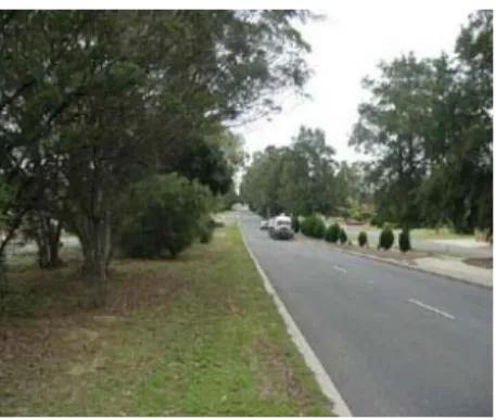
Suburbs in the southern part of the City of Wanneroo were developed in the late 1970’s and early 80’s. The street tree planting reflects a preference for native trees. These trees have matured to form large majestic street trees, particularly on the primary road network. The primary roads in this area, including Wanneroo Road, Alexander Drive, and Beach Road are characteristically wide, with large randomly planted gums and irregular ‘bush’ understorey. The secondary road network has recently been replanted with Eucalyptus siderloxylon’ rosea.
Central Localities
The Central Localities includes suburbs that are associated with the development of Joondalup city centre. The street tree planting reflect an increased interest in streetscape design and the influence of thematic design of landscapes in new residential estates. There has been a shift from the extensive Australian species to exotic species. This is largely due to a perceived market preference and the marketability of instant streetscapes with strong landscape themes. The street tree planting is regular and consistent, with a low understorey (usually grass). The predominant species used in this area are Figure 3 Mixture of mature Australian trees
and bush understorey along Alexander Drive, Alexander
Figure 4 Eucalyptus siderloxylon ‘Rosea’ has been recently planted in secondary roads in the southern
City of Wanneroo Street Tree Master Plan
Landscape Character Analysis 13
Last Revised September 2005
deciduous trees including Fraxinus sp., Liquidambers, Plane Trees and Jacarandas. The deciduous trees form a strong contrast to the woodland of the natural landscape.
Coastal Suburbs
The coastal suburbs reflect a similar focus on the streetscape design as the central suburbs. As with the central suburbs there is an emphasis on regular street tree planting which acts as a contrast to the surrounding natural vegetation. Avenues of tall trees (including Norfolk Island Pines, Cotton palms) are used along both the secondary and primary streets, as a contrast to the generally low vegetation associated with the coast.
Rural Roads
There is a network of rural roads through the northern part of the City. The street trees in the road reserve of the rural network are predominantly remnant vegetation. In areas where street trees have been planted they usually act as a windbreak or a visual screen.
2.3.1 National Parks Bushland, Wetlands & locally native species Remnant locally native trees often occur in road reserves that pass through National Parks, regional parks, bush forever sites and rural bushland. These trees form part of the surrounding bushland structure and are indicators of the local vegetation association and soil type. In and national parks show
2.3.2 Street Tree Trends
Over recent years there has been increased interest in street trees due to their contribution to the quality of a streetscape. Increased interest has led to a shift from the extensive use of Australian species to deciduous and exotic species.
The City of Wanneroo has cited a number of concerns with this development, in particular the increased maintenance required to
Figure 6 Queenscliff Parade, Quinns Rocks, is an example of the extensive use of mature exotic trees (Norfolk Island Pines) that has occurred in the coastal localities.
Figure 7 & 8 Rows of large eucalypts along rural roads such as Pinjar Road, Pinjar and Karoborup Road, Carabooda, form wind breaks and visual screens. a
Figure 5 Transplanted mature trees are used to create instant streetscapes. Eg. Corner of Kingsbridge Boulevard and Shelford
City of Wanneroo Street Tree Master Plan sustain a large number of deciduous trees in environmentally unsuitable conditions and the resulting expense to all ratepayers in the City of Wanneroo. As such a first preference for locally native and Australian trees has been proposed with the requirement that deciduous and exotic street tree planting meet with council approval before being undertaken.
2.3.3 Tree Planting Policy
To date there has been no specific street tree policy in the City of Wanneroo. Tree location has been dictated by landscape guidelines by the City, the requirements of Main Roads WA and public infrastructure providers as well as planting by community groups and ratepayers. There is no coherent theme to street tree planting in the City of Wanneroo and whilst there are many local examples of street trees that could provide a basis for subsequent planting they do not provide a clear structure on which to base the whole street tree strategy.
2.4 Biophysical Analysis
2.4.1 Weather and Climate
The climate of Perth is classified as Mediterranean with cool mild winters and hot dry summers. Sub tropical high-pressure cells that advance south dominate the weather patterns in summer and retreat north in winter. The summer months see the prevailing winds come from the east, with relief to coastal areas provided by the south-westerly sea breezes, and the winter months see prevailing winds come from the west accompanying the cold fronts originating in the lower latitudes. The Perth area has an average annual rainfall of 800mm of which a majority falls in the four-month winter period between May and August. The summer months are subject to extreme drought, a factor which is intensified by the easterly and south-westerly wind patterns.
Figure 10 &11 Cheriton Drive, Carramar (top) and Marchwood Boulevard, Butler are examples of the extensive use of exotic trees in new residential estates. The landscape treatment for both suburbs is very similar and does not express the identity of Wanneroo or the natural environment.
Figure 9 Majestic white trunk eucalypts form a strong avenue effect along Wanneroo Road, Yanchep.
City of Wanneroo Street Tree Master Plan
Landscape Character Analysis 15
Last Revised September 2005
The micro climate has a significant impact on the vegetation within the City of Wanneroo. It varies as the topography changes and the distance from the coast increases. Vegetation along the coast is exposed to salt spray and wind. The west facing dunes also tend to be hot and dry from direct heat from the afternoon sun. Where the dunes become more stable, and more protected, taller vegetation appears, particularly in the depressions.
2.4.2 Soil Associations
The City of Wanneroo is located on the Swan Coastal Plain where the geomorphology is dominated by a series of ancient sedimentary dune systems deposited during the sea level fluctuations of ice ages and interglacial periods. There are three major dune systems in the City of Wanneroo with the youngest being the Quindalup dunes located on the coast, the intermediate being the Spearwood dune system characterised by the limestone ridges and the oldest being the Bassendean dune system extending16 km inland to the beginning of the Darling Scarp. These dune systems form the geomorphology of the Wanneroo area, combining with climate, to dictate the structure of locally native plant communities. Within these three major dune systems there are further sub-groupings for soil types and the related plant communities known as associations.
Quindalup Dune System
The Quindalup dune system is located along the coast, extending at times to 4 Kilometers inland to meet the Cottesloe association ridges. The soil type is white, with a high concentration of lime, ‘Aeolian’ or wind borne sand that is generally unconsolidated forming the undulating ridges of the primary and secondary dune systems. The Quindalup plant association has very few locally native trees of significant stature due to soil with low fertility and high alkalinity and predominantly exposed windy conditions.
Figure 12 Soil Associations within the City of Wanneroo
Adapted from Perth Metropolitan Region Land
Resource Survey – Rural Area 23/5/85
City of Wanneroo Street Tree Master Plan
Spearwood Dune System
The Spearwood dune system consists of shallow brown and bright yellow sands over a limestone ridge running north to south, occasionally touching the coastline. The Spearwood dune system consists of a number of different soil associations that contain specific vegetation types; they are the Cottesloe, the Karrakatta and the Herdsman associations.
Cottesloe Association
The Cottesloe association is a series of ridges, hills and hollows that run in a north south Direction whilst extending 5-7 km in width.
They are characterised by shallow brown or bright yellow sand loam over limestone with limestone outcropping occurring in some areas. There is a further distinction between the Cottesloe soils and the Cottesloe ridges as the higher topography of the ridges displays much shallower soils, more limestone outcropping and significantly less trees. Karrakatta Association
The Karrakatta association consists of deep sand recognised in a ‘yellow’ and ‘grey’ phase. The yellow phase has a grey/ brown sandy surface that passes into bright yellow siliceous sand and limestone- often within two metres. The grey phase has a grey sandy surface, a very light grey sub-surface, pale yellow sand beneath and limestone at depth. The Karrakatta soil types typically occur on the eastern side of the Cottesloe ridge and represent the most fertile of the soil associations in the Wanneroo area. The deeper, fertile soils of the Karrakatta zone originally supported the greatest diversity of tree species and are also those most favoured for agricultural practices. Herdsman Association
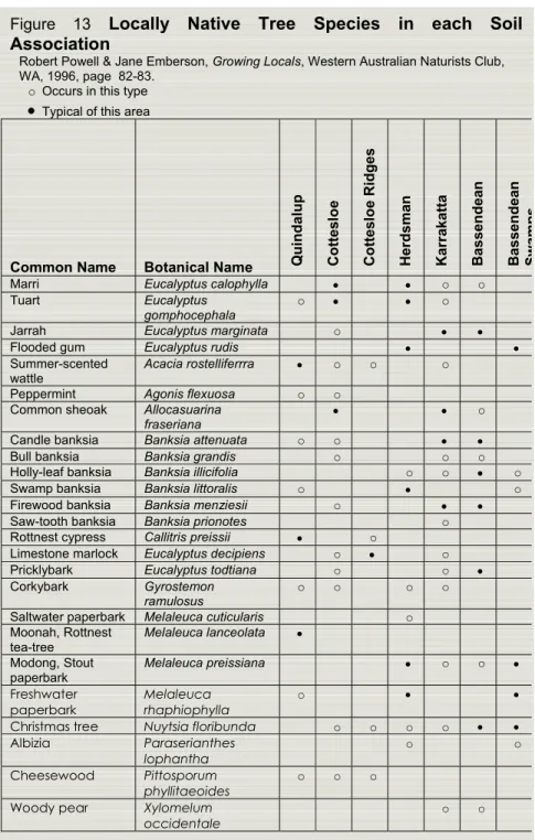
The Herdsman soil type is located around the Linear Lakes and swamps that run in a north south direction including Joondalup, Nowergup, Neerabup and Carabooda Lakes and the swamps of the Yellagonga Regional Park. The soil consists of black peaty sand over Figure 13 Locally Native Tree Species in each Soil
Association
Robert Powell & Jane Emberson, Growing Locals, Western Australian Naturists Club, WA, 1996, page 82-83.
o Occurs in this type • Typical of this area
Common Name Botanical Name Q
u indalup Co tt es lo e Co ttes lo e Rid g es Herd sman Karr akatta Bas sen dea n Bas sen dea n Swamp s
Marri Eucalyptus calophylla • • o o
Tuart Eucalyptus
gomphocephala o • • o
Jarrah Eucalyptus marginata o • •
Flooded gum Eucalyptus rudis • •
Summer-scented
wattle Acacia rostelliferrra • o o o Peppermint Agonis flexuosa o o
Common sheoak Allocasuarina
fraseriana • • o
Candle banksia Banksia attenuata o o • •
Bull banksia Banksia grandis o o o
Holly-leaf banksia Banksia illicifolia o o • o
Swamp banksia Banksia littoralis o • o
Firewood banksia Banksia menziesii o • •
Saw-tooth banksia Banksia prionotes o
Rottnest cypress Callitris preissii • o
Limestone marlock Eucalyptus decipiens o • o
Pricklybark Eucalyptus todtiana o o •
Corkybark Gyrostemon
ramulosus o o o o
Saltwater paperbark Melaleuca cuticularis o
Moonah, Rottnest
tea-tree Melaleuca lanceolata • Modong, Stout
paperbark
Melaleuca preissiana • o o •
Freshwater
paperbark Melaleuca rhaphiophylla o • •
Christmas tree Nuytsia floribunda o o o o • •
Albizia Paraserianthes
lophantha o o
Cheesewood Pittosporum
phyllitaeoides o o o
Woody pear Xylomelum
City of Wanneroo Street Tree Master Plan
Landscape Character Analysis 17
Last Revised September 2005
light grey sand with occasional brown mottling. The soil of The Herdsman association (Beondaddy sand) generally occurs within 1 metre of the water table. The Herdsman association has fewer tree species than the Karrakatta and Cottesloe associations that surround it and primarily consists of trees that can handle high water tables and seasonal inundation.
Bassendean Dune System
The Bassendean Dune System runs in a north-south direction and extends eastward to an extent of 16 Kilometers. The Bassendean Dune System is the oldest of three and consists predominantly of heavily leached soils with poor drainage as well as swamp land represented by the Circular Lakes- Lake Pinjar, Mariginiup Lake, Lake Jandabup and Gnangara Lake. They are very infertile as their minerals and plant nutrients have largely been leached out. In the western part of the Bassendean association the areas around the Circular Lakes display a range of wetland and eucalypt woodland species whilst the majority of the association is an undulating topography of successive low hills comprising of highly leached grey sand. Drainage in these sands is poor with moisture passing through higher ground rapidly whilst collecting in lower ground on an impermeable hardpan made from vegetative litter. Vegetation on the grey sands of the Bassendean association is predominantly banksia woodland with a number of eucalypts also present. Mature pine plantation is now also a dominant feature in the Bassendean soil association.
2.4.3 Hydrological Features of the Study Area
The major Hydrological features recognised in the study area are the Linear Lakes including Joondalup, Nowergup, Neerabup and Carabooda that are located in the Herdsman soil association and the Circular Lakes; Gnangara, Pinjar, Marginup and Jandabup that are located in the Bassendean soil association. Both types are surface expressions of the groundwater level, fluctuating seasonally, to create a
City of Wanneroo Street Tree Master Plan
number of different permanent lakes, seasonal swamps and waterlogged damplands.
City of Wanneroo Street Tree Master Plan References used for the soil association, plant information and hydrological features are:
Powell, R. & Emberson, J. Growing Locals (1996); Western Australian Naturists Club, WA
Mc Arthur, WM & Bettenay, E (1974) The Development and distribution of the Soils of the swan Coastal Plain, CSIRO Publication No.16 Rippey, E. & Rowland, B. Plants of the Perth Coast and Islands (1995) University of Western Australia Press, WA
City of Wanneroo Street Tree Master Plan
The Road Network in the City of Wanneroo 21
Last Revised September 2005
3.0 The Road Network in the City of Wanneroo 3.1 Existing Road Networks
The existing road network in the City of Wanneroo possesses a variety of streetscapes indicative of the diverse land uses present in the City. Whilst the spatial form of streetscapes differs greatly in response to land uses they are predominantly dictated by a hierarchy consisting of Primary, Secondary and Tertiary road types. Primary roads represent the major arterial routes, Secondary roads allow access to suburbs and Tertiary roads represent the finer weave of the residential streets. The Primary Road Network displays a further distinction between the roads that run in a north-south direction, such as Wanneroo Road and Marmion Avenue, and those that run in an east-west direction, such as Hepburn Avenue and Beach Road. The East-West roads provide access to the suburbs and carry a lower volume of traffic whilst north south roads generally carry a larger volume of traffic and provide access to the greater metropolitan area.
The road network also provides access to farming areas predominantly located in the eastern section of the City. This road network is characterised by relatively long stretches of open road, sharing characteristics with the major arterial routes whilst carrying a significantly lower volume of traffic.
3.2 Future Road Networks
In recent years the significance of public infrastructure, of which transport networks are a critical component, has gained prominence as the basis of a healthy urban environment.
As such public infrastructure is seen as the foundation of urban form
City of Wanneroo Street Tree Plan
22 The Road Network in the City of Wanneroo
sustainability with the aim of providing efficient and equitable mobility for all users.
The increased concern for a sustainable transport network has prompted a revised approach to the design of new roads, and was applicable or adaptable to modifications to existing roads. This approach is fully outlined in the publication Liveable Neighbourhoods - A Western Australian Government Sustainable Cities Initiative,Edition 2 (2000), which promotes the inclusion of cyclists, public transport, private vehicles and freight with increased safety measures and increased focus on the visual and environmental components of streetscapes.
3.3 Metropolitan Functional Road Hierarchy
The City of Wanneroo’s road network is managed in accordance with its function. The Metropolitan Functional Road Hierarchy (MFRH) was derived in order to:
• Make roads easier to use – roads will be managed in a way to make their function more obvious to users. Roads of the same function will have similar traffic management measures regardless of location. This will mean less unexpected traffic devices on unfamiliar roads.
• Make roads easier to manage – Management decisions will only need to be within the scope of appropriate measures for the designated function.
• Make easier planning – Land use and road function are closely related. It will communicate the intended function of roads to existing and prospective landholders.
The road types and criteria are summarised as follows:
Primary Distributors
These provide for major regional and inter-regional traffic movement and carry large volumes of generally fast moving traffic. Some are Typically 60m Reserve
Primary Distributor (MFRH & LN)
City of Wanneroo Street Tree Master Plan
The Road Network in the City of Wanneroo 23
Last Revised September 2005
strategic freight routes and all are National or State roads. They are managed by Main Roads. Wanneroo Road within the City of Wanneroo is the only road that falls into this category.
District Distributor A
These carry traffic between industrial, commercial and residential areas and generally connect to Primary Distributors. These are likely to be truck routes and provide only limited access to adjoining property. They are managed by Local Government. Typically Hepburn Avenue, Mirrabooka Avenue and Hester Avenue fall into this category.
District Distributor B
Type B District Distributors perform a similar function to type A District Distributors but with reduced capacity due to flow restrictions caused by access to and roadside parking alongside adjoining property. These are often older roads with a traffic demand in excess of that originally intended. District Distributor A and B roads run between land-use cells and generally not through them, forming a grid which would ideally space them around 1.5km apart. They are managed by Local Government. Typically Two Rocks Road, Flynn Drive, Lenore Road and Girrawheen Avenue fall into this category.
Local Distributors
Local Distributors carry traffic within a cell and link to District Distributors at the boundary to access roads. The route of Local Distributors discourages through traffic so that the cell formed by the grid of District Distributors only carries traffic belonging to or serving the area. These roads should accommodate buses but discourage trucks. They are managed by Local Government. Typically Quinns Road, Clarkson Avenue and Dundebar Road fall into this category.
Access Roads
Access Roads provide access to abutting properties with amenity, safety and aesthetic aspects having priority over the vehicle movement
Varies 25-60m Reserve District Distributor (MFRH)
Integrator Arterial (LN)
(2 lanes with central median, no parking embayment)
Typically 20m Reserve Local Distributor (MFRH)
Neighbourhood Connector (LN) (no median, parking embayment)
Typically 25m Reserve District Distributor (MFRH)
Integrator Arterial (LN)
City of Wanneroo Street Tree Plan
24 The Road Network in the City of Wanneroo
function. These roads are bicycle and pedestrian friendly. They are managed by Local Government.
A full description of the Metropolitan Functional Road Hierarchy Road Types and Criteria is tabled in Appendix A.
Recent land planning reform through the introduction of Liveable Neighbourhoods (LN) concept has resulted in reclassification of the road types. In summary reflected as follows:
Metropolitan Functional Road Liveable Neighbourhoods
(LN)
Hierarchy (MFRH)
Primary Distributor Primary Distributor
District Distributor A&B Integrator Arterials
Local Distributors Neighbourhood Connectors
Access Roads Access Streets
3.4 Street Tree Location
Street trees generally occur in 2 places in the streetscape:
Median Strips
The median strip, located in the centre of the carriageway, can vary from 1 to 6 m in width, presenting a place to locate street trees. It is particularly useful if the verges are particularly tight and private property setbacks are small as it can provide foliage to both sides of the street. The median may also provide planting locations if overhead power lines prohibit planting on either verges.
Nature Strips
The nature strip, as defined in the Road Traffic Code 2000 and previously known as the verge, are located on either side of the road carriageway. They provide planting locations that contribute to an Figure 15 Typical sections of roads relevant to the City of
Wanneroo
Adapted from Liveable Neighbourhoods, Edition 2
(2000), Western Australian Planning Commission.
Typically 16m Reserve Access road (MFRH)
Access Street (LN)
City of Wanneroo Street Tree Master Plan
The Road Network in the City of Wanneroo 25
Last Revised September 2005
avenue effect. This space is also shared by pedestrian and cyclist paths, parking and public infrastructure such as overhead power lines and underground services.
3.5 Summary of the Road Network
The City of Wanneroo has a number of different road types based on adjacent land uses and a typical primary, secondary and tertiary road hierarchy. New developments and upgrades of the existing road networks will, wherever possible be based on the Liveable Neighbourhoods model.
The Street Tree Master Plan list will continue to refer to road types using Liveable Neighbourhoods terminology as discussed in Section 3.3.
City of Wanneroo Street Tree Plan
26 The Role of the Tree in the Streetscape
4.0 The Role of the Tree in the Streetscape
In the City of Wanneroo, trees from private property, public open spaces, agriculture, and commercial practices all make valuable contributions to the streetscape. Street trees however, are specifically defined as those trees in the road reserve located on the nature strips, median strips and traffic islands as well as focal points and other planting that primarily address the streetscape. Street trees provide a number of positive elements to a streetscape. These include:
• Visual and spatial unity in a streetscape. • Articulation of focal points and distances.
• Definition of boundaries and corridors at a local scale.
• Delineation of pedestrian and vehicular spaces within the streetscape .
• Traffic calming.
• Shade for pedestrians and vehicles.
• Positive manipulation of the streetscape microclimates. • Increased land values through preferable lifestyles.
• Reduced impact of exhaust emissions through tree respiration. • Habitat for avifauna and other animal life.
• Wildlife corridors between natural bushland areas.
In the City of Wanneroo street trees also cover remnant vegetation located in the road reserve and trees located in the road reserves of National Parks.
4.1 Existing Streetscapes
Many streets within the City of Wanneroo have street trees creating a distinct streetscape. Where streetscapes with street trees already exist, new trees planted in extensions to existing roads or to replace those that have died will match the others in the street design rationale of the existing streetscape. Street tree requests are assessed by the City of Wanneroo to ensure that the tree is in keeping with the existing streetscape and will meet criteria for suitable street tree. The City of
Fig
Figure 16 Avenue street trees are an important element in creating a successful streetscape eg. Sugar Gums (Eucalyptus cladocalyx) Lovekin Drive, Kings Park, Perth.
City of Wanneroo Street Tree Master Plan
The Role of the Tree in the Streetscape 27
Last Revised September 2005
Wanneroo has produced a brochure entitled; Nature Strip (Verge) Treatment Guidelines to assist residents in carrying out landscaping and other improvement works to the nature strip adjoining their property.
Street trees have a number of uses that require a considered design approach. These are listed below:
4.2 Avenue Tree Planting
Street trees are typically planted in avenues of regular spacing on the verges and median strips.
4.3 Buffer/Combination Screen Planting (BC)
Tree species that are suitable as part of noise attenuation and visual screening are identified as buffer species. They are typically located on the Primary Distributor and Integrator Arterial road types and may be a backdrop for taller trees that are closer to the carriageway. Local plant species should be used whenever there is no specific purpose that excludes their use.
4.4 Public Open Space (POS)
Road reserves adjoining public open spaces (POS), bushland sites and regional parks present opportunities to use species that would not normally be used as street trees due to the relaxed spatial requirements. Road reserves adjoining public open space present the opportunity to plant larger trees due to the increased amount of space and reduced risk of impact on surrounding buildings and public infrastructure. In road reserves adjoining bushland sites and regional parks, any remnant trees should be conserved. Any additional street tree planting should also be locally native to strengthen the presence of bushland in the City of Wanneroo.
Figure 17 Buffer planting can be used
as a windbreak or visual screen. Eg. Benmuni Road, Wanneroo.
Figure 18 Street tree planting can enhance the identity of a retail precinct. Eg. The Golden Locusts (Gledetsia tricanthos)
in Paley Park, New York have become famous.
City of Wanneroo Street Tree Plan
28 The Role of the Tree in the Streetscape
4.5 Retail and Commercial Precincts (RC)
Trees in retail and commercial precincts assist in providing an attractive identity and act as a visual indication of a change in land use. Trees in retail and commercial precincts should be used to shade car parks and pedestrian thoroughfares. Deciduous trees can be used along north facing building facades and outdoor plazas where passive solar principles apply.
4.6 Passive Solar (PS)
The significance of trees in relation to microclimates and the thermal performance of buildings require the consideration of planting to aid thermal comfort through passive solar design. Medium to high density urban areas may benefit from the selection of deciduous trees to provide shade in summer whilst allowing warmth and light to enter during winter, particularly if there are narrow Access Streets and laneways where the road reserve is 14m or less.
4.7 Landmark (LM)
Landmark tree species are trees that are of significant stature as to provide a major contribution to the legibility of the landscape in which they are located. The Norfolk Island Pine is one example as it contributes to both streetscape experienced by pedestrians and vehicles as well as being prominent on the skyline as a significant cultural addition to the landscape. The significance of landmark tree species requires that they are located carefully with consideration to their impact on the overall landscape.
4.8 Feature Trees (FT)
Feature trees are often used to increase the legibility of the road network, by providing visual cues at the entry of new developments, commercial precincts, intersections and roundabouts.
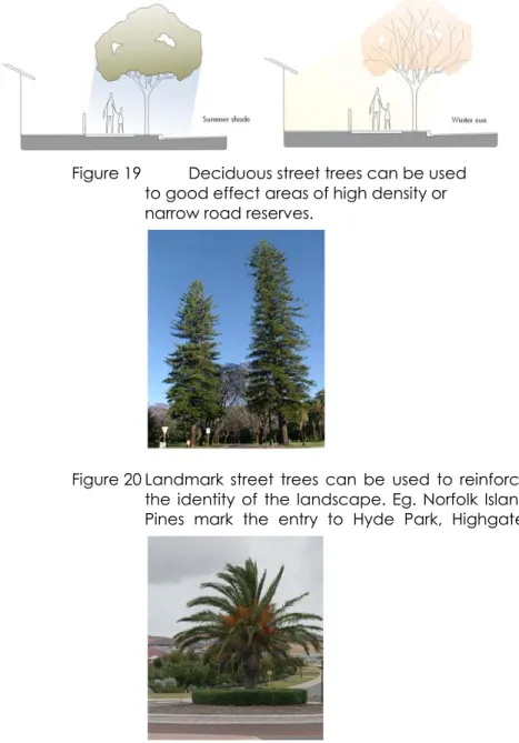
Figure 19 Deciduous street trees can be used
to good effect areas of high density or narrow road reserves.
Figure 20 Landmark street trees can be used to reinforce the identity of the landscape. Eg. Norfolk Island Pines mark the entry to Hyde Park, Highgate.
Figure 21 Feature street trees can be used to improve the legibility of the road hierarchy. Eg. Santa Barbara Parade & James Cook Avenue,
City of Wanneroo Street Tree Master Plan
Design Parameters 29
Last Revised September 2005
5.0 Design Parameters
A number of design parameters influence the selection, application and management of street trees. The decision of what tree to use will usually require the consideration of:
• Aesthetic criteria- the habit, growth, form and streetscape experience intended.
• Environmental criteria- the impact of the selected planting on the environment.
• Economic criteria- The ability to maintain the planting during initial phases and in an ongoing capacity.
• Residential criteria – the impact of the selected planting abutting residential property.
5.1 Street Context
When planning a streetscape consideration must be given to the aesthetic and cultural character of the area. Parameters that impact on the tree selection include the scale of the street, adjoining land uses, continuity with surroundings and recognition of features within the area, including parks or significant buildings.
Recommendations:
• Consider the scale of the street – width of street and height of buildings on either side determine the size of the tree.
• Consider the adjoining land uses (commercial, residential, retail, POS), access requirements and the quantity of pedestrian and vehicular traffic.
• Provide continuity and consistency along a whole street. Each street should have single character along its whole length.
• Where streetscapes with street trees already exist, new trees planted in extensions to existing roads or to replace those that have died will match the others in the street design rationale of the existing streetscape.
• Use trees to complement the existing features of the streetscape.
Figure 22 Use a street tree that suits the scale of the street. Smaller trees suit narrow road reserves, while larger trees are suitable in large road reserves.
Local street
Neighbourhood connector
Figure 23 To create a distinctive streetscape
the trees should be planted close together. This diagram illustrates the effect of close tree planting vs distant tree planting.
City of Wanneroo Street Tree Plan 5.2 Tree Spacing
Tree spacing will be driven by the size of the selected tree, cost implications as well as safety, visibility, vehicular thoroughfares and the desired effect on the streetscape. If the tree spacing is close together it gives an atmosphere of confinement that can aid in traffic calming measures. If they are far apart and evenly spread they can convey the sense of an open boulevard with views to the spaces beyond. When setting tree spacing the mature size of the trees, the proportion of the trunk and canopy, and how they will impact on each other need to be taken into account. Large trees that work best on the larger road reserves do not require such dense spacing because the shading capacity is less important and they are usually experienced at greater speeds.
5.3 Tree Planting & the Environment
5.3.1 Local Environmental Strategy
The City of Wanneroo prepared a Local Environmental Strategy in 2002. Key areas of the strategy include biodiversity, the greenhouse effect, and water management. Street tree planting in the urban environment can provide numerous environmental benefits within these key areas. Tree planting is becoming increasingly recognised for its contribution to the reduction of green house gas levels. The use of locally native species can contribute to local biodiversity by providing wildlife corridors and enhancing native remnant bushland.
Recommendations:
• Provide street trees on all streets throughout the City.
• Promote planting of locally native tree species particularly adjoining existing bushland, wetlands, Bush Forever sites, National Parks and Landscape Enhancement Areas.
• Use street trees that are drought tolerant.
• Retain any remnant locally native trees that occur in the road reserves.
Figure
Figure 24 Streets in the Landscape Enhancement Areas should be planted with locally native tree species.
City of Wanneroo Street Tree Master Plan
Design Parameters 31
Last Revised September 2005
5.3.2 Preference for Locally Native Trees
The City of Wanneroo has a preference for the use of locally native tree species as street trees. Native trees, local and Australian, have many advantages that are consistent with the environmental focus of the City of Wanneroo. However, the City of Wanneroo recognises that in certain situations (for example where there are passive solar requirements) exotic trees, particularly deciduous trees, may be an appropriate selection.
The use of exotics in combination with natives within the road reserve will be considered in a favourable manner by the City when assessing landscape plans for approval. Such consideration would need to be supported by appropriate justification based on sound design principles and the mix of exotic and native species design in such a manner that the streetscape not only appeals from an aesthetic perspective, but also addresses traffic management (pedestrian, cyclist and vehicular movements) and associated road safety implications.
5.3.3 Weeds
Some trees, including Australian and local species, have the potential to become weeds if planted in inappropriate settings. Weeds can occur in a number of ways:
• Excessive growth, such as suckering.
• Growth in ecologically sensitive areas, competing with locally native plant species.
• Blocking of waterways and adverse effects on waterway margins.
Advantages of Australian species • Resilience in local conditions.
• Tolerance to drought and water logging. • Generally reliable growth rates and habit.
• Reduced maintenance, pruning, reticulation and fertilizer applications.
• Comparatively lower resource use, including water and fertilizer.
• Comparatively lower nutrient loads entering the groundwater and water bodies through applied fertilizer and seasonal leaf drop, particularly in wetland areas.
• Reduced possibility of weed species.
• Provide wildlife corridors between natural bushland areas.
Advantages of Exotic Species
• Deciduous trees allow sunlight and warmth to enter during winter.
• Some species exhibit seasonal interest such as autumn colour and spring flush
City of Wanneroo Street Tree Plan Adverse effects from deciduous street tree species may also become evident a long way from the planting as the leaf drop of deciduous trees can contribute to excessive nutrient loading into waterways borne through artificial runoff systems as well as ground water.
5.3.4 Fire Management
Since a high proportion of the City of Wanneroo is rural, remnant bushland, and National Parks, fire is a major concern.
The use of street trees poses minimal additional risk to this condition if management and maintenance of the trees are continued as part of the general upkeep of the road reserve. In many instances street trees may reduce the risk posed by fires as they act as windbreaks, reducing the impact of spot fires.
To reduce the risk of fire street trees require regular maintenance to remove dead foliage, twigs and branches and clearing of the ground below to create an effective barrier. There are a number of measures that may be taken to reduce the risk of fire transmission through street trees, particularly in areas with a high risk:
Recommendations:
• In areas of high risk use fire resistant or hard to burn street tree species.
• Select trees that have smooth bark or do not shed their bark readily.
• Select trees with a natural high salt content. Figure 25
List of Environmental Weed Species of Actual and Potential Significance in WA (CALM)
Refer to Appendix B for Detailed Criteria for Assessment and Rating • High - Rating a weed species as high would indicate prioritising this
weed for control and/or research ie prioritising funding to it. Trees that fall into this category include:
Leptospermum laevigatum
• Moderate - Rating a weed species as moderate would indicate that
control or research effort should be directed to it if funds are available, however it should be monitored (possibly a reasonably high level of monitoring). Trees that fall into this category include:
Eucalyptus citriodora Eucalyptus cladocalyx Eucalyptus maculata Ficus carica Olea europaea Pinus pinaster Pinus radiata
• Mild – a weed species scoring one of the criteria. A mild rating would indicate monitoring of the week and control where appropriate. Trees that fall into this category include:
Eucalyptus botryoides Washingtonia filifera
• Low – A low ranking would mean that this species would require a low level of monitoring. Trees that fall into this category include:
Acacia baileyana Cassia fistula Casuarina cunninghamiana Casuarina equisetifolia Casuarina glauca Eucalyptus globules Eucalyptus muelleriana Eucalyptus polyanthemos Eucalyptus saligna Gleditsia triacanthos Grevillea robusta Lagunaria patersonii Mangifera indica Pinus canariensis Pinus halepensis Pinus pinea Platanus x acerifolia Populus alba Populus nigra Salix babylonica Tamarindus indica Ulmus procera
City of Wanneroo Street Tree Master Plan
Design Parameters 33
Last Revised September 2005
• Space trees with an adequate distance to remove the possibility of transmission through the canopy.
• Implement an effective tree management program to maintain trees by removing dead branches and ground leaf litter.
• Allow significant clearance between the ground and canopy.
• Maintain a safe distance from power lines as stipulated by Western Power (refer to the next section Trees and Public Infrastructure).
• Be mindful of the proximity to the built environment in bushfire prone areas and do not allow the predicted canopy to overhang nearby buildings.
5.4 Trees and Public Infrastructure
Street trees within the City of Wanneroo generally exist in road reserve surrounded by public utilities include power, gas, water, sewer and built infrastructure such as footpaths, kerbs and roadways. Main Roads WA has Code of Practice for Utility Providers which guides the protection of utilities in road reserves. The document recommends suitable location for tree planting within the road reserve in relation to public utilities and infrastructure. It also deals with the protection of stands of native vegetation within the road reserve. The document is available on Main Roads WA website (www.mainroads.wa.gov.au). Street trees may impact on public infrastructure and the built environment in a number of foreseeable ways:
• The canopy can conflict with streetlights, overhead power lines and buildings.
• Invasive root systems that enter utilities and damage built infrastructure.
Recommendations
• Preserve existing street trees when installing or upgrading public infrastructure.
Figure 26 More fire resistant native trees include:
Lilly Pilly Acmena smithii Juniper Myrtle Agonis juniperina Apple Jack Angophora costata Kurrajong Brachychiton populneus River She-Oak Casuarina cunninghamiana Spotted Gum Eucalyptus maculata Moreton Bay Fig Ficus macrophylla Coastal Hibiscus Lagunaria patersonii Moonah Melaleuca lanceolata White Cedar Melia azedarach Sweet Pittosporum Pittosporum undulatum Brush Box Lophostemon conferta Introduced plants that are hard to burn include:
Common Maple Acer campestre Norway Maple Acer negundo Evergreen Alder Alnus jorullensis Carob Ceratonia siliqua
Ash Fraxinus spp.
Bay Tree Laurus nobilis Olive Olea europaea Red-leaf Photinia Photinia glabra Plane Tree Platanus orientalis Popular Populus spp. Cherry laurel Prunus laurocerasus Portugal Laurel Prunus lusitanica Algerian Oak Quercus canariensis Holly Oak Quercus ilex
English Oak Quercus robur Willow Salix babylonica Pepper Tree Schinus molle Tamarix Tamarix aphylla
Elm Ulmus spp.
List adapted from NSW Rural Fire Service. Please contact your local nursery to obtain a list of plants suitable for your area.
City of Wanneroo Street Tree Plan
• Placement of trees should be determined in relation to underground and overhead services.
• Consider planting street trees under the overhead wire closest to the road kerb to facilitate formative pruning over the road surface to form a canopy.
• Use street trees that suit the location. For example, low trees should be planted next to power lines.
• Obtain approval prior to clearing native vegetation (from the City of Wanneroo and Department of Environmental Protection) from a road reserve.
• Contact Dial before you dig (WA) to confirm service alignment within developed road reserves prior to tree planting. Telephone: 1100 website (www.dialbeforeyoudig.com.au)
• Seek to minimise invasive roots damaging public infrastructure and all buildings, through species selection.
• Trees in urban areas must be planted with an effective physical root barrier as required by City of Wanneroo to protect against root damage.
• Consider the impact to surrounding utilities by mature planting.
5.5 Trees and Road Safety
Trees in the road reserve should be planted according to Main Roads WA ‘Environmental Guidelines – Vegetation Placement within the Road Reserve’. The document set outs recommended vegetation setbacks and clearances on roads to ensure drivers have good visibility of pedestrians and other vehicles, particularly at intersections. Street trees can also assist in road safety to calm traffic by creating a sense of confinement. Enclosing the street with trees reduces motorists’ peripheral vision prompting them to drive at slower speeds.
Recommendations
• Consider the location of the planting in relation to on-street parking, footpaths and setbacks, sightlines and intersections. Figure 27 Western Power and FESA require a 2m
clearance around power lines.
Figure 28 Location of underground services in the verge.
City of Wanneroo Street Tree Master Plan
Design Parameters 35
Last Revised September 2005
• Consider the impact of the planting in relation to sightlines and safety.
• Maintain street trees to a minimum of two metres between the ground and canopy to keep clear sight lines for pedestrians and vehicles.
5.6 Tree Management
It is essential for the City of Wanneroo to manage, protect and maintain trees for the benefit of the community. Street trees are a long term asset and, once mature, are irreplaceable in a short period of time. The City of Wanneroo needs to develop a street tree maintenance strategy that:
• Ensures that tree care and maintenance is performed to Australian Standards level (AS-4373-1996 Pruning of Amenity Trees).
• Conducts regular audits of street trees using the City of Wanneroo 7.3.2 policy manual regarding upgrades to distributor roads and parks.
• Maintains historically accurate data relating to street trees.
5.6.1 Tree Protection
Work on public infrastructure and structures in proximity to street trees should be mindful of the adverse impacts of excavation and soil compaction on the trees’ root systems and take steps to avoid disturbing them. Since a majority of a tree’s root system occurs in the 500mm of soil located beneath the drip line, excavation in this area should be avoided. Also, compaction of soil in the drip line due to vehicle traffic or heavy temporary structures can also adversely affect the trees’ root system and should be avoided. Trees also need protection from wind damage when young, vehicle damage and vandalism.
• Use shelters to establish trees in coastal environments.
• Use bollards, tree stakes, or tree guards to protect trees located in the median or next to car parking.
Figure 29 It is important to maintain clearances to ensure sightlines between pedestrians and vehicles are clear.
City of Wanneroo Street Tree Plan • Significant earth works and level changes near mature street
trees should consider the extent of the trees’ root system.
• When trenching in verge, consider trenching under tree instead of along side the tree to minimize root damage.
5.6.2 Growth & Maintenance
All trees have an expected growth habit dictated by their species type that is also affected by local environmental conditions and human interaction. All trees in the road reserve should be encouraged to attain their expected habit through correct pruning and maintenance techniques. This can be achieved primarily through good species selection as well as consideration of the surrounding elements of the streetscape and the implementation of a maintenance routine that can minimise the adverse impact of street trees.
5.6.3 Tree Pruning
Tree pruning may occur for a number of reasons:
• Formative pruning during initial planting stages.
• Removal of limbs that constitute a physical or visual obstruction or pose to be a hazard if dead or dying.
• Removal of invasive or destructive roots.
All modifications to trees including root systems should be carried out by qualified tree surgeons to minimise the risk of disease entry and damage to adjacent property.
5.6.4 Tree Removal
The removal of trees may occur for a number of reasons:
• An obstruction to the safe functioning of a streetscape through physical or visual obstruction.
• Destruction of public infrastructure and structures by root systems and branches.
• Senescent trees that detract from the overall character of the streetscape.
City of Wanneroo Street Tree Master Plan
Design Parameters 37
Last Revised September 2005
• Trees that are disease affected and likely to die shortly or transmit the infection.
• Trees that constitute an undue burden on the City of Wanneroo tree maintenance program.
Tree removal will be carried out by council staff or qualified tree surgeons using all of the necessary safety equipment to below ground level for safety and to minimise the possibility of re-growth. Tree surgeons should have adequate public liability insurance. Removal of street trees in the road reserves requires the permission of the City of Wanneroo.
5.6.5 Tree Availability and Planting
The availability of trees from commercial growers varies due to seasonal and species demand as well as application requirements. Current industry practice indicates that if a substantial number of trees in avenue planting are proposed it is recommended that they be selected at least a year in advance. Trees need to be a minimum of 2m high at the time of planting. Planting should occur in the wetter months from April to October for unirrigated trees. Planting of irrigated trees can occur throughout most of the year provided adequate watering is undertaken. At the time of planting the trees should be tied and staked to City of Wanneroo standards.
5.6.6 Impact of Tree Selection on Maintenance
Trees must be selected that are suitable to the location, their function in the streetscape and the reduction in ongoing maintenance and resource use. Trees shed bark, leaves, twigs and limbs as well as having the cyclical process of flowering and fruiting. These characteristics of trees can dictate their suitability to the streetscape environment and can pose a risk to public safety and impact on maintenance routines including