Cross-Reference System for Translating Between Genetic Soil Classification of China
and Soil Taxonomy
X. Z. Shi, D. S. Yu, E. D. Warner,* W. X. Sun, G. W. Petersen, Z. T. Gong, and H. Lin ABSTRACT
Soil classification systems are not consistent among countries or organizations thereby hindering the communication and organiza-tional functions they are intended to promote. The development of translations between systems will be critical for overcoming the gap in understanding that has resulted from the lack of a single internation-ally accepted classification system. This paper describes the applica-tion of a process that resulted in the translaapplica-tion of the Genetic Soil Classification of China (GSCC) to Soil Taxonomy (ST). A brief history of soil classification in China is also provided to familiarize readers with GSCC and its origins. Genetic Soil Classification of China is the attribute base for the recently assembled digital form of the 1:1 000 000 soil map of The People’s Republic of China. The translation between GSCC and ST was based on profile, chemical, and physical descrip-tions of 2540 soil series. First, the 2540 soil series were classified to their equivalent soil order, suborder, great group, and subgroup according to ST and GSCC subgroup descriptors. Order names for both classification systems were then linked to corresponding map units in the 1:1 000 000 digital soil map of China using a geographic information system (GIS). Differences in classification criteria and in the number of orders of the two systems (there are more GSCC orders than ST orders) meant that each GSCC order could possibly be assigned to more than one ST order. To resolve the differences, the percent correspondence in area between orders was determined and used as the criterion for assigning GSCC orders to ST orders. Some percentages of correspondence were low so additional pro-cessing was used to improve the assignment process. The GSCC subor-ders were then matched with ST orsubor-ders. When the area for each order was summarized, the percentage of correspondence increased except for two subgroups in the Ferrasols order.
C
LASSIFICATIONis a fundamental part of the rational study and management of soil resources, serving as an organizational framework and descriptor of soil properties. Systematic soil classification is also a vehicle for communicating research results and extending the benefits of new knowledge to other locations. Classifica-tion in conjuncClassifica-tion with soil mapping provides a method for planning agricultural output, makes possible the ap-plication of new management techniques, and supports the use of environmentally sound land use practices.To date there is no universally accepted soil classifica-tion system. Internaclassifica-tionally, only Soil Taxonomy (ST) (Soil Survey Staff, 1994) and World Reference Base for Soil Resources (WRB) (FAO/ISRIC/ISSS, 1998) are
used extensively. ‘‘Soil Classification–A Global Desk Reference’’ edited by noted soil taxonomists, was pub-lished recently, to stimulate formation of an interna-tional soil classification system (Eswaran et al., 2003). Even given the development of an internationally recog-nized system, a great deal of time will have to be dedi-cated to translating existing systems into the new global standard.
Soil classification in China provides an interesting example of how systems can be cross-referenced to improve the understanding of soil properties. Soil classi-fication in China has undergone several important trans-formations, resulting in the creation of two soil classifi-cation systems based on different academic philosophies, namely GSCC and Chinese Soil Taxonomy (CST). Cur-rently the two systems are used together. Nevertheless, the large volumes of soil data and information gathered and accumulated since the initiation of the study of soil science in the early 1930s, including soil maps and soil survey reports, have mostly been prepared and sorted on the basis of GSCC. For example, the second national soil survey (1979–1994) was documented using GSCC, as were all the soil maps and soil survey reports at all administrative levels (township, county, city, province, and country).
Genetic Soil Classification of China, however, differs sharply from ST, which is used extensively throughout the world. Since non-Chinese scientists and other users of soil data outside of China do not know much about GSCC, it is extremely difficult for Chinese soil scientists to exchange information, cooperate with foreign col-leagues, and publish papers in international journals. Further, it is difficult for soil scientists from countries outside of China to acquire a working knowledge of GSCC terminology and criteria, because the source ma-terials are published in Chinese, which is not a familiar second language for many soil researchers.
To overcome these obstacles, Chinese scientists know and are compelled to translate all soils information on the basis of ST. However, such translations are per-formed on an individual basis without guidance on how to conduct them, increasing the possibility for inconsis-tencies when relating soils from one system to another. So that while Chinese soil scientists are familiar with ST, there is no national standard for translating between the two systems.
The solution was to establish a reference system be-tween GSCC and ST. To that end, Chinese soil scientists have been devoting untiring efforts (Shi and Gong, 1996, 2004b; Gong et al., 1999, 2000). Some initial studies have been done to get an idea of how the two systems might
X.Z. Shi, D.S. Yu, W.X. Sun, and Z.T. Gong, State Key Laboratory of Soil and Sustainable Agriculture, Institute of Soil Science, Chinese Academy of Sciences, Nanjing, China; E.D. Warner, G.W. Petersen, and H. Lin, Office for Remote Sensing of Earth Resources, The Pennsylvania State University, University Park, Pennsylvania, USA. Received 29 Sept. 2004. *Corresponding author (edw103@psu.edu). Published in Soil Sci. Soc. Am. J. 70:78–83 (2006).
Pedology
doi:10.2136/sssaj2004.0318
ªSoil Science Society of America 677 S. Segoe Rd., Madison, WI 53711 USA
Abbreviations:GIS, Geographical Information System; GSCC, Ge-netic Soil Classification of China; ST, Soil Taxonomy.
Reproduced from Soil Science Society of America Journal. Published by Soil Science Society of America. All copyrights reserved. 78
be related. The study of the 20 red soil profiles in Jiangxi and Fujian provinces revealed that 12 of them were Ultisols, 4 Alfisols, and the other 4 Inceptisols in ST (Shi and Gong, 1996). In 1999, the soil orders of the ‘‘Chinese Soil Taxonomy’’ were used as guides and for each soil order, several soil profiles were cited. A total of 64 soil profiles were used for attempting a link be-tween the Chinese Soil Taxonomy, GSCC, ST, and FAO legend units (Gong et al., 1999).
Although much work has been done in studying refer-ences between some soil series, the number of soil pro-files examined in the previous studies were far too lim-ited to form definitive relationships. A translation method to date was needed to help develop soil science in China and to enable academic exchanges with foreign investi-gators. Moreover, based only on dozens of soil profiles, the reference between the two systems was not robust by drawing from a limited sample of the diversity of soils found across the country. To improve the range of soils considered in the reference system, ‘‘Soil Species of China (six volumes)’’ and ‘‘Soil Species of Selected Provinces’’ were consulted to identify attributes of each soil species according to GSCC and ST. Statistics were used to help define rules that were a reference for establishing the correlation between the two systems.
A note about terminology is appropriate here, as we have used the words soil species to denote a basic unit of soil classification, which makes it equivalent to soil series as it is understood by those familiar with Ameri-can soil science. Soil species was a term adopted from the former Soviet Union, which had the dominant influ-ence on soil classification in China after the revolution in 1954. After this point we will use the soil series exclu-sively except when referring to accepted translations of references, but readers should be aware that the term soil species is still widely used in Chinese soil literature.
HISTORY OF SOIL CLASSIFICATION IN CHINA Soil classification research in China began in the early 1930s, through the introduction of methods from the USA, devel-oped from the work of C.F. Marbut. As a result some 2000 soil series were identified. In 1930, the first paper describing soil survey and classification in China was released, followed in 1934 by the first research report concerning the same topic. In 1936, a book entitled ‘‘Soil Geography of China’’ presented the first general description of soils in China at a national scale (Thorp, 1936). In 1941, the first Chinese soil classification system was drafted and used as a basis for the identification of soils in most of the country.
In 1954, the genetic classification approach was introduced from the former Soviet Union, which was strongly based on the setting of the soil’s location. From this introduction, a genetic soil classification was proposed for adoption as a national system. Extensive investigations were made for classifying and naming cultivated soils, further modifying the genetic soil clas-sification system according to the formation factors relevant to the country. In 1978 a standard genetic soil classification of China—‘‘Provisional Draft of Soil Classification of China’’ (Gong et al., 1978) was established. The proposed classifica-tion had three levels: soil order, great group, and subgroup. This classification had an extensive basis and adopted soil names that had long been used in the country. The system was soon
recognized by the soil science community in China and ac-cepted as the basis for soil classification in the second national soil survey. In 1979, the ‘‘Soil Working Classification System (Revised draft)’’ was formulated for the second national soil survey. The draft, after several amendments, was developed into the ‘‘Genetic Soil Classification System of China’’ in 1992. And in 1998, a six level soil classification system was com-pleted, that is, order, suborder, great group, subgroup, family, and series (Xi et al., 1998).
MATERIALS AND METHODS
The flow of the investigation is depicted in a series of steps used to create the cross reference between GSCC and ST (Fig. 1). Two data sets were used in this investigation, which were processed using a GIS to efficiently summarize the dif-ferent soil classification descriptors, and match them across systems.
The first data set used in the cross-reference study was taken from ‘‘Soil Species of China (six volumes)’’ (The Office of the Second National Soil Survey of China, 1993, 1994, 1995, 1996) and ‘‘Soil Species of Selected Provinces,’’ which pro-vided information on 2540 soil series collected from locations throughout China. The attributes of the soil profiles are used as the initial link between GSCC and ST. It should be noted that these were selected from a set of 30 000 profile descrip-tions collected as part of the second National Survey. The second National Survey resulted in the creation of a 1:1 000 000 scale map for the whole country (The Office for the Second National Soil Survey of China, 1995), among other documents and studies. The 2540 soil series records were the ones from the total 30 000 that were deemed complete enough to provide sufficient information for determining the classification in both GSCC and ST.
The basic attributes for each soil series are composed of descriptive and quantitative data recorded in thematic sec-tions. One section lists classification (soil great group, sub-group, and family), geographic distribution, major soil proper-ties, profile characteristics and production capacity. Major soil properties recorded include parent material and soil profile structure and thickness of the soil layer. The data for profile
Reproduced from Soil Science Society of America Journal. Published by Soil Science Society of America. All copyrights reserved.
characteristics detail location, elevation, parent material, cli-matic information (such as annual mean temperature), natural vegetation, and crops on the profile site. The second section is referred to as the field profile record, which describes each soil layer with such characteristics as color, texture, and struc-ture of the soil layer and plant root system therein. The third and final section lists such attributes as soil physical properties, soil chemical properties, and soil nutrients.
A group of experienced pedologists and mapping experts were assembled to review the soil series information and as-sign both GSCC and ST classifications to the subgroup level. The process was an iterative one, with classifications proposed and then reviewed, to assure consistency in the assignment process.
The second data set used in this investigation is the newly created digital version of the 1:1 000 000 scale soil map of China. A geographic information system (GIS) was used to link the 1:1 000 000 scale soil map to the profile attribute information based on the GSCC family descriptor. The basic map unit is the soil family, of which there are 909. In total the actual number of polygons mapped for the entire country isf94 000, of which there are 235 soil subgroups, 61 soil great
groups and 12 soil orders (Shi et al., 2004a). The original form of the map was a hardcopy series, each of which was compiled on a provincial basis. The hardcopy maps exist now as a single digital database and include all the original detail.
RESULTS
Distribution of Chinese Soils according to
Genetic Soil Classification of China and
Soil Taxonomy
Attribute data for the 2540 soil series described above serve as the initial link between GSCC and ST. Among the 12 GSCC soil orders, Anthrosols dominate, account-ing for 571 of the 2540 soil series. Anthrosols are followed by Amorphic soils and Semi-Aquatic soils, accounting for 367 and 361 of the 2540 soil series, respectively. Profile data for Ferralsols, Alfisols, Semi-Alfisols, Pedocals, and Alpine soils, number between 100 and 300 each. Aridi-sols, Desert soils, Aquatic soils, and Alkali-saline soils are represented by,100 soil series within each group.
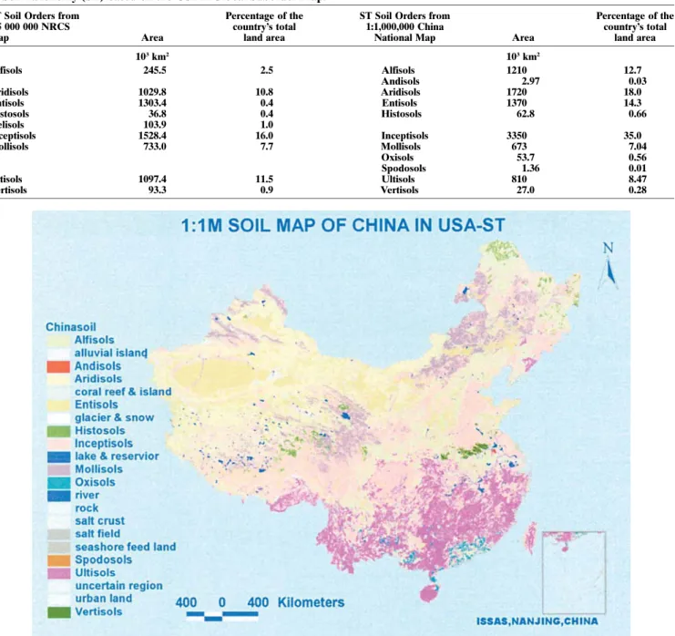
By aggregating soil series into higher and higher lev-els, a ST soil order distribution map of China was com-piled (Fig. 2). Based on the digital soil map, the total area of each soil order for the two soil classification systems and the percentage of China’s total land area were determined (Table 1). Note that the percentages listed do not include 3% of the land mapped as non-soil. As is shown in the table, Alpine soils and Morphic soils are the two soil orders in GSCC that have the greatest area, accounting for 1980 and 1630 3103km2 or 20.7 and 17.0% of the country’s total land area, re-spectively. The areas of the ST soil orders, however, are rather uneven. Among the 12 soil orders, the Inceptisols cover 33503103km2, accounting for 35.0% of the coun-try’s total; while Andisols, Histosols, Oxisols, Spodosols, and Vertisols, each cover ,1.0%, Alfisols, Aridisols, and Entisols, each range between 10 to 20%, and Ulti-sols and MolliUlti-sols between 6 to 10%.
Table 2 compares ST soil orders according to the 1:1 000 000 China national soil database and ST soil or-ders as mapped with the Global Soil Suborder Map
(USDA, 2000). The NRCS Global Soil Suborder Map was produced by modifying the FAO-UNESCO Soil Map of the World with another NRCS product, a soil climate map. For consistency the suborders have been aggregated to orders. As can be seen there is little corre-spondence between the percentage of area mapped by the two sources. Equally interesting, is the amount of non-soil land, 3 and 35% for the national China soil database and NRCS map, respectively. It is beyond the scope of this article to explain these differences, but certainly they can be attributed to such factors as scale, source information, and human interpretation.
Cross-reference Between GSCC and
ST Soil Orders
The systems can be cross-referenced now that the 1:1 000 000 soil map has been attributed according to both ST and GSCC. A frequency operation was per-formed on the database so that each unique GSCC order was listed with each ST order that share a mapped polygon. The area and percentage of the total area of each GSCC order accounted for by each associated ST order identified by the frequency operation were then determined. For example, 75.6 and 23.5% of the area mapped as Anthrosols in GSCC occur as Inceptisols and Alfisols in ST, respectively. The referencibility or co-occurrence, of GSCC soil orders to their correspond-ing ST orders is listed in Table 3. As can be seen, the correspondence between orders from the different sys-tems varies widely.
From Table 3 it can be seen that Desert soils in GSCC are directly equivalent to Aridisols in ST. However, Amorphic soils in GSCC could be interpreted into seven different ST soil orders: Entisols, Inceptisols, Alfisols, Aridisols, Ultisols, Andisols, and Mollisols, with their referencibility being 62, 26.9, 6.96, 6.96, 0.41, 0.18, and 0.05%, respectively. The maximum percentage of refer-encibility for each GSCC matching a ST order varies widely from 100 to 42.2%. Based on referencibility, the soil orders in GSCC can be divided into three categories, high, intermediate, and low. Soil orders in GSCC with referencibility values above 80% fall into the high cate-gory, including Desert soils, Aridisols, and Semi-Aquatic soils. The maximum referencibility values for Desert soils and Aridisols to Aridisols in ST reaches 100 and 97%, respectively. The intermediate category for frequency values varies between 60 and 80%, and includes Anthro-sols, Alkali-saline soils, Amorphic soils, AlfiAnthro-sols, and Fer-ralsols, whose respective counterparts in ST are Incepti-sols, AridiIncepti-sols, EntiIncepti-sols, AlfiIncepti-sols, and Ultisols. The low category has referencibility values below 60%, including Semi-Alfisols, Pedosols, Aquatic soils, and Alpine soils, whose respective counterparts in ST are Alfisols, Molli-sols, InceptiMolli-sols, and Inceptisols.
Improving the Cross-reference of GSCC to ST
In the discussion above, it is obvious that some soil orders in GSCC have high referencibility. For instance, Desert soils in GSCC have a 100% correspondence to Aridisols in ST, that is to say there are no other ST soil
Reproduced from Soil Science Society of America Journal. Published by Soil Science Society of America. All copyrights reserved.
Table 1. Genetic Soil Classification of China (GSCC) and Soil Taxonomy (ST) soil order area and proportion in GSCC and ST based on the 1:1 000 000 China National Map.
GSCC Soil Orders from 1:1 000 000 China
National Map Area
Percentage of the country’s total
land area
ST Soil Orders from 1:1 000 000 China
National Map Area
Percentage of the country’s total land area 103km2 103km2 Ferralsols 1120 11.8 Alfisols 1210 12.7 Alfisols 1060 11.1 Andisols 2.97 0.03 Semi-Alfisols 428 4.48 Aridisols 1720 18.0 Pedocal 591 6.18 Entisols 1370 14.3 Aridisols 306 3.21 Histosols 62.8 0.66
Desert soils 604 6.32 Inceptisols 3350 35.0
Amorphic soils 1630 17.0 Mollisols 673 7.04
Semi-Aquatic soils 747 7.82 Oxisols 53.7 0.56
Aquatic soils 147 1.53 Spodosols 1.36 0.01
Alkali-saline soils 184 1.92 Ultisols 810 8.47
Anthrosols 489 5.11 Vertisols 27.0 0.28
Alpine soils 1980 20.7
Table 2. Soil order area and proportion in Genetic soil classification of China (GSCC) from the 1:1 000 000 China National Map and Soil Taxonomy (ST) based on the USDA Global Suborder Map.
ST Soil Orders from 1:5 000 000 NRCS
Map Area
Percentage of the country’s total
land area
ST Soil Orders from 1:1,000,000 China
National Map Area
Percentage of the country’s total land area 103km2 103km2 Alfisols 245.5 2.5 Alfisols 1210 12.7 Andisols 2.97 0.03 Aridisols 1029.8 10.8 Aridisols 1720 18.0 Entisols 1303.4 0.4 Entisols 1370 14.3 Histosols 36.8 0.4 Histosols 62.8 0.66 Gelisols 103.9 1.0 Inceptisols 1528.4 16.0 Inceptisols 3350 35.0 Mollisols 733.0 7.7 Mollisols 673 7.04 Oxisols 53.7 0.56 Spodosols 1.36 0.01 Ultisols 1097.4 11.5 Ultisols 810 8.47 Vertisols 93.3 0.9 Vertisols 27.0 0.28
Fig. 2. Soil Taxonomy soil order distribution map of China.
Reproduced from Soil Science Society of America Journal. Published by Soil Science Society of America. All copyrights reserved.
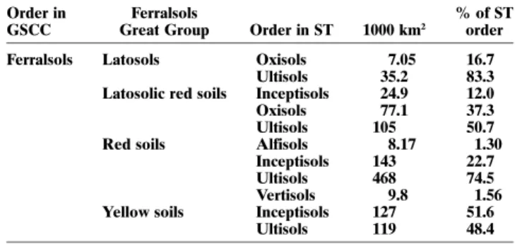
orders that were included in the classification of Desert soils. Some, however, have a low correspondence. Fer-ralsols in GSCC have its greatest proportion of matched area to Ultisols in ST, being only 60.7%. That means that nearly 40% of the area classified in GSCC as Ferral-sols are cross-referenced as some ST order other than Ultisols. So to make the reference system more consis-tent, additional processing was undertaken. It was de-cided to cross reference those GSCC great groups with low correspondence on the basis of soil orders.
Table 4 shows reference of soil groups under Soil Order Ferralsols in GSCC to soil orders in ST. Under the order of Ferralsols there are four great groups, Lato-sols, Latosolic red soils, Red soils, and Yellow soils. The number of soil orders in ST that each great group is referenced to is generally limited. For instance, Latosols and Yellow soils have only two orders each. On the other hand, the referencibility of Latosols and Red soils to Ultisols in ST is raised by a large margin to 83.3 and 74.5%, respectively. But the referencibility of the other two groups, Latosolic red soils and Yellow soils, is other-wise. In this case, changing the soil classification unit for cross-referencing doesn’t improve the correspondence. Another approach to improve the referencibility might be to use a regional subdivision of the soil data. A
regional subdivision might capture variability related to climate differences in the country.
SUMMARY
After classification of the 2540 soil profiles and linking the profile attributes to the 1:1 000 000 soil map, it is found that the 12 soil orders in ST distribute unevenly in China. Among Andisols, Histosols, Oxisols, Spodosols, and Vertisols, none exceeds 1.0% of the country’s total land area; Inceptisols have the largest land coverage, being 33503 103km2or 35.0% of the country’s total; Alfisols, Aridisols, and Entisols range between 10 and 20%, whereas Ultisols and Mollisols range between 6 and 10%.
In terms of maximum proportion of correspondence to soil orders in ST, the soil orders in GSCC vary signifi-cantly from 100 to 42.2%. The category with agreement greater than 80% includes Desert soils, Aridisols and Semi-Aquatic soils. The category with moderate agree-ment, lower than 60%, includes Semi-Alfisols, Pedocals, Aquatic soils, and Alpine soils. Soil orders in GSCC with referencibility above 80% fall into the category of high, in-cluding Desert soils, Aridisols, and Semi-Aquatic soils. The referencibility of Desert soils and Aridisols to Aridi-sols in ST reaches 100 and 97.7%, respectively. The inter-mediate referencibility category varies between 60 and 80%, including Ferrasols, Alfisols, Amorphic soils, Alkali-saline soils, and Anthrosols, whose respective counter-parts, determined by referencibility, in ST are Ultisols, Alfisols, Entisols, Aridisols, and Inceptisols. Although the two soil classification systems differ sharply in theory and basis, the application of GIS for determining a rela-tion bridging them is a promising initial step. Neverthe-less, more efforts shall be devoted to establish coinci-dence relationships with higher referencibility between the two systems. For instance, establishing the reference from a lower classification level or subdividing the data based on some regional basis may provide better coinci-dence between the two systems.
Table 3. Cross-reference of soil orders in Genetic soil classification of China (GSCC) to those in Soil Taxonomy (ST).
GSCC Soil Order ST Soil Order 1000 km2 Referencibiliy% GSCC Soil Order ST Soil Order 1000 km2 Referencibility%
Ferralsols Alfisols 8.2 0.73 Amorphic soils Alfisols 112 6.91
Inceptisols 294 26.2 Andisols 1.4 0.08
Oxisols 84.1 7.49 Aridisols 29.4 1.81
Ultisols 727 64.7 Entisols 1133 69.8
Vertisols 9.8 0.87 Inceptisols 349 21.5
Alfisols Alfisols 716 67.6 Semi-Aquatic soils Entisols 74.6 9.99
Inceptisols 202 19.0 Inceptisols 650 87.0
Spodosols 0.1 0.01 Mollisols 0.4 0.06
Ultisols 142 13.4 Vertisols 22.1 2.95
Semi-Alfisols Alfisols 232 54.3 Aquatic soils Alfisols 0.2 0.11
Inceptisols 120 28.0 Histosols 57.7 39.3
Mollisols 75.7 17.7 Inceptisols 88.8 60.6
Pedocal Alfisols 114 19.3 Alkali-saline soils Alfisols 1.0 0.52
Aridisols 11.2 1.89 Aridisols 82.4 44.9
Inceptisols 49.1 8.31 Entisols 24.4 13.3
Mollisols 417 70.5 Inceptisols 76.0 41.4
Aridisols Alfisols 5.6 1.84 Anthrosols Alfisols 104 21.3
Aridisols 298 97.2 Inceptisols 385 78.7
Inceptisols 2.9 0.96 Alpine soils Aridisols 574 29.0
Desert soils Aridisols 604 100 Entisols 299 15.1
Inceptisols 996 50.4
Mollisols 109 5.52
Table 4. Reference of soil groups under the order of Ferralsols in Global soil classification of China (GSCC) to soil orders in Soil Taxonomy (ST).
Order in GSCC
Ferralsols
Great Group Order in ST 1000 km2
% of ST order
Ferralsols Latosols Oxisols 7.05 16.7
Ultisols 35.2 83.3
Latosolic red soils Inceptisols 24.9 12.0
Oxisols 77.1 37.3
Ultisols 105 50.7
Red soils Alfisols 8.17 1.30
Inceptisols 143 22.7
Ultisols 468 74.5
Vertisols 9.8 1.56
Yellow soils Inceptisols 127 51.6
Ultisols 119 48.4 Reproduced from Soil Science Society of America Journal. Published by Soil Science Society of America. All copyrights reserved.
ACKNOWLEDGMENTS
We gratefully acknowledge support for this research from the Innovation Project of the Chinese Academy of Sciences ISSASIP0201 & the Natural Science Foundation of Jiangsu Province (Project # BK2002504) and the National Key Basic Research Support Foundation (Project # G 1999011810). We also want to recognize the support of Dr. Edwin Sheffner of NASA’s Earth Science Enterprise (Grant EOS/03-0000-0610).
REFERENCES
Eswaran, H., T. Rice, R. Ahrens, and B. Stewart. 2003. Soil classifica-tion. A global desk reference. CRC Press, Boca Raton, FL. FAO/ISRIC/ISSS. 1998. World reference base for soil resources.
World Soil Resources Reports. FAO, Rome.
Gong, Z.T., Q.G. Zhao, S.Z. Zeng, P. Lin, and R.C. Wang. 1978. A drafting proposal for soil classification of China. Soil 10(5):168–169. Gong, Z.T., Z.C. Chen, G.B. Lou, G.L. Zhang, and W.J. Zhao. 1999.
The reference of Chinese soil taxonomy. Soil 31(2):57–63. Gong, Z.T., Z.C. Chen, W.J. Zhao, and H. Shi. 2000. Classification
of ferrallitic soils in Chinese soil taxonomy. Pedosphere 10(2):125– 133.
The Office for the Second National Soil Survey of China. 1995, Soil map of People’s Republic of China. Mapping Press, p. 1–60. The Office for the Second National Soil Survey of China. 1993. Soil
Species of China. Volume I. Chinese Agriculture Press, Beijing. The Office for the Second National Soil Survey of China. 1994. Soil
Species of China. Volume II. Chinese Agriculture Press, Beijing.
The Office for the Second National Soil Survey of China. 1994. Soil Species of China. Volume III. Chinese Agriculture Press, Beijing. The Office for the Second National Soil Survey of China. 1995. Soil
Species of China. Volume IV. Chinese Agriculture Press, Beijing. The Office for the Second National Soil Survey of China. 1995. Soil
Species of China. Volume V. Chinese Agriculture Press, Beijing. The Office for the Second National Soil Survey of China. 1996. Soil
Species of China. Volume VI. Chinese Agriculture Press, Beijing. Shi, X.Z. 1993. A Suggestion for establishing Alfisols and Cambisols
in the Chinese Soil Taxonomy. p. 18–23.InAdvances of the Chinese Soil Taxonomy. Science Press, Beijing.
Shi, X.Z., and Z.T. Gong. 1996. Reference comparison of soil types in southeast China under different soil classifications (in Chinese). Chinese J. Soil Sci. 27(3):97–102.
Shi, X.Z., D.S. Yu, E.D. Warner, X.Z. Pan, G.W. Petersen, Z.G. Gong, and D.C. Weindorf. 2004a. Soil Database of 1:1,000,000 Digital Soil Survey and Reference System of the Chinese Genetic Soil Classification System. Soil Survey Horizon 45:129–136. Shi, X.Z., D.S. Yu, W.X. Sun, H.J. Wang, Q.G. Zhao, and Z.T. Gong.
2004b. Reference benchmarks relating to great groups of genetic soil classification of China with soil taxonomy. Chin. Sci. Bull. 49(14):1507–1511.
Soil Survey Staff. 1994. Keys to soil taxonomy. 6th ed. U.S. Gov. Print. Office, Washington, DC.
Thorp, J. 1936. Geography of the soils of China. The National Geologi-cal Survey of China. Nanjing, China.
USDA. 2000. Global soil regions map. Natural Resources Conserva-tion Service, Soil Survey Division, World Soil Resources, Washing-ton, DC.
Xi, C.F., et al. 1998. Soils of China. (In Chinese.) Chinese Agriculture Press, Beijing. Reproduced from Soil Science Society of America Journal. Published by Soil Science Society of America. All copyrights reserved.