AN EFFICIENT ROAD TRACKING FROM AERIAL IMAGES
BY MEANS OF FILTER METHODS
K.MADHAN KUMAR1, R.KANTHAVEL2
1Assoc Prof., Department of Electronics & Communication Engineering, PETEC, Vallioor
2 Prof., Department of Electronics & Communication Engineering, VEC, Chennai
E-mail: [email protected], [email protected]
ABSTRACT
To many geographic systems (GIS) application scheme such as urban planning and navigation, updating road network database is critical problem. Rapidly changing urban environments accelerate the need for frequent updates or revisions of road network databases. With the advent of high-resolution satellite images, there has been a resurgence of research interest in road extraction techniques. However, due to the extreme complexity of an urban scene, automatic road network extraction continues to be challenging research topic. In this paper, we have proposed a road map extraction system with two efficient filters using satellite images. Here, Unscented Kalman filter (UKF) is used in combination with Gauss-Hermite Kalman Filter (GHKF) to trace and identify various connected road paths and to avoid obstacles under diverse conditions. Unscented Kalman filter (UKF) component is responsible for tracing axis coordinates of a road region until it comes to a severe obstacle or an intersection. Then, the Gauss-Hermite Kalman Filter (GHKF) module takes the control of the road extraction process and regains track of the road or possibly road branches on the other side of a road junction or obstacle. From the results, we ensure that the proposed road extraction technique outperformed the existing approach by achieving the accuracy of 98.452% in cluster 10.
Keywords:
Unscented Kalman Filter (UKF) And Gauss-Hermite Kalman Filter (GHKF), Satellite Image, Road Extraction,1. INTRODUCTION
Recently road extraction from satellite imagery has emerged as one of the hot topics in the research field. It is particularly employed in the city planning, cartography and to revise already detected roads in Geographic Information Systems (GIS) environment [11]. Road extraction is a crucial aspect for the resourceful utilization of high resolution satellite images. Some of the several applications of road extraction are renewal of GIS database, reference for image registration, assistance for identification algorithms and fast mapping [23]. Road extraction enables the road network to be truly presented in the object space when the image to ground systems transformation is carried out and it has been described as the method of detection and precise localization of roads in the image [17]. Automatic road extraction attempts to simplify and speed up the road extraction process by focusing on automating all or few parts of this process. Spatial data capturing and updating for GIS applications give prime importance to road extraction from high resolution imagery [18]. In photogrammetry and digital
image processing fields, road extraction is considered as a challenging issue. Comprehensive research has been carried out on road extraction from aerial and satellite imagery. Semi-automatic and fully automatic are two main types of road extraction method. Being an interactive technique between the user and the computer algorithms, initial point(s) and a direction for road tracking algorithm are chosen by the operator in Semi-automatic feature extraction. Conversely, input from an operator is not required by the fully automatic methods which work on their own [24] [26] [27].
from an urban scene. This research topic is still challenging, and the fact that valuable toolkits including practical semiautomatic ones are not
offered by commercial vendors of
photogrammetric system for automated road extraction demonstrate its importance [19]. The magnitude of automation incorporated by them decides the mentioned classification of the road extraction methods. Semiautomatic methods find out a road object and provide a small quantity of information related to it based on the arbitration of an operator such as seed points [20]. Development or improvement of semiautomatic techniques is necessary to permit the fast, consistent and precise provision of data for GIS systems as such fully, or even almost fully, automated processes have not attained a mature state [22].
In this paper, we have designed an efficient road extraction system using unscented kalman filter and Gauss-Hermite Kalman Filter. Starting from the initial point, UKF module is proceed to the next point on the road. This process is done by UKF and GHKF for each next point selection. In each step the process uses noisy measurement to obtain the best estimate of the state of the road at that point, with reference with the updated profile.
The rest of the paper is organized as follows: a brief review of some of the literature works in road extraction techniques are presented in Section 2. Contribution is discussed in section 3. The proposed road extraction technique is detailed in Section 4. The experimental results and performance evaluation discussion is provided in Section 5. Finally, the conclusions are summed up in Section 6.
2. RELATED RESEARCHERS: A BRIEF REVIEW
Various road extraction techniques and their explanation are listed in this section. Now-a-days, Satellite and aerial images are the most important available data sources for map generation and updating of available maps and they have highly improved in terms of spatial, spectral and temporal resolutions. Research communities are overwhelmed by the sheer volume of collected images, the necessity of automatic generation of road map and map updating seems to be very important. Due to its difficulty of extracting the road map automatically, many researchers have been carried out in this area with human intervention. In accordance with this, for road-tracking from satellite images, numerous significant algorithms and methods are published
in this area. In this class, the Extended Kalman Filter (EKF) is one of the methods, which was proposed in initial for road map extraction in [2] and then was further widened in [3] and [4]. For nonlinear filtering, Particle Filters (PFs) are utilized and to trace a single road path initiated by a given seed at the beginning of the road the algorithms based on PF have been utilized in [5] and [6]. The limited processing area on the image is alone the fault of the prior works in the aforesaid class of road extraction methods [2]-[6]. Moreover these algorithms exploit EKF or PF, start tracing a road from a given seed point on the road, and generally halt when they attain a stern occlusion, an intersection, or even dramatic change in the road direction.
In order to recover the trace of the road beyond obstacles, Movaghati S et al. [1] have combined EKF with a special Particle Filter (PF) in addition to determine and follow diverse road branches after reaching to a road junction in recent. In their approach, EKF has traced a road at initial until a stopping criterion is met. Then, instead of terminating the process, the results were shifted to the PF algorithm which attempts to determine the extension of the road after a probable obstacle or to recognize all possible road branches that might exist on the other side of a road junction. They have modified the procedure, for further enhancement, for attaining the measurements by decoupling this process from the current state prediction of the filter. The potential for instability of the road-tracing algorithm has been condensed by the elimination of dependence of the measurement data to the predicted state. Furthermore, in order to uphold tracking when the road profile endures some variations due to alterations in the road width and intensity, they have constructed a method for dynamic clustering of the road profiles. This technique motivated to continue my research on the road extraction of satellite images with the aid of filtering and clustering techniques.
Curve fitting was utilized. To track the road boundaries over time in an image sequences, Kalman filter was utilized. Experimental output displayed that the design algorithm efficiently tracked a wide range of road models.
A two-step approach i.e. detecting and pruning had been formed by Jiuxiang Hu et al. [8] for automatic extraction of road networks from aerial images. The road detection step was based on shape categorization of a local homogeneous region around a pixel. A polygon, called the footprint of the pixel covered the local homogeneous region. This step involved in finding out road footprints, tracking roads, and growing a road tree. To get the road footprint, a spoke wheel operator was utilized by them. An automatic road seeding method was made by them based on rectangular approximations to road footprints and a toe-finding algorithm to categorize footprints for growing a road tree. The road tree pruning step utilized a Bayes decision model based on the area-to-perimeter ratio (the A/P ratio) of the footprint to prune the paths that leaked into the environments. To characterize the conditional probability of A/P ratios of the footprints in the road tree, a lognormal distribution was introduced by them. Also, the lognormal distribution was utilized to show an automatic method to assess the parameters that were concerned to the Bayes decision model. Results were shown for different aerial images.
A method for road extraction from high resolution imagery was demonstrated by P.N. Anil and Dr. S. Natarajan [9]. Statistical region merging in the image segmentation step was utilized by them, followed by thresholding. A skeleton pruning by discrete curve evolution was utilized in the next step to take out the road network. This method was tested on various high resolution test images and output found satisfactory. The drawback of the method was that it might not work on the road cast by shadows. Another algorithm was demonstrated by Movaghati S et al. [1] based on a specific combination of the EKF and the PF as a road-tracing approach for satellite images. The algorithm created by them included two modules i.e. the EKF module and the PF module. Those two modules which utilized clustering algorithms were able to pass severe obstacles on the road and to search and trace all road branches at a junction. The projected algorithm had been checked on an IRS satellite image with 5.8-m spatial resolution and an IKONOS satellite image with 0.8-m spatial resolution. To initialize the algorithm, all road segments in a connected road network were traced by only using a single seed point. The developed
algorithm, moreover, remained rich regard-less of sudden changes in the road direction and differences in the road width and intensity.
A method was explained by Aleksey Boyko and Thomas Funkhouser [10] for taking out roads from a big scale unstructured 3D point cloud of urban surroundings. It was including several superimposed scans taken at various times. By giving a road map and a point cloud, the road surfaces from the rest of the point cloud were automatically separated by this method. Beginning with an approaching map of the road network provided in the form of 2D intersection locations joined by polylines, at first, a 3D representation of the map was made by optimizing Cardinal splines to decrease the distances to points of the cloud under continuous restraints. Then, a road net-work into independent patches was separated by them, making it possible to work on a large point cloud with a small in-memory working set. For every patch, in order to forecast the locations of curbs, a 2D active contour to an attractor function with peaks at small vertical discontinuities was fit by them. Lastly, a set of labelled points was resulted by them, wherein the points lying within the active contour were marked as ‘‘road’’ and the others were not.
3. CONTRIBUTION OF THE PROPOSED TECHNIQUE
The main contributions of our proposed technique are:
Road extraction using non-linear filter needs to be initialized for each road extracted. In other words, it needs a starting point (seed point). In existing literatures, the seed point selection is a challenging problem and various techniques were presented for solve this problem. To solve the initialization problem, in this paper, an automatic initial seed point is generated using grid based clustering and road extraction system is started from this seed point.
process and regains track of the road or possibly road branches on the other side of a road junction or obstacle.
4. PROPOSED ROAD EXTRACTION SYSTEM
Road extraction is still a demanding issue of research in the field of digital photogrammetry. A variety of literatures have been developed to address the issue automatic road extraction. One significant category of road extraction technique is related on probabilistic modeling of associated data and Bayesian estimation techniques. Statistical models are utilized to represent characteristics of the road features in above road extraction schemes. In general, these techniques consist of two stages: prediction phase and update phase. Extended Kalman Filter (EKF) is one of the techniques in
[image:4.595.124.467.352.671.2]this class, which was first developed for road map extraction in literature [12] and then was extended in literature [13] and [14]. By analyzing the literature, we found that the effective improvement over the EKF is provided the guaranteed improved performance compared with EKF. EKF is the nonlinear version of the Kalman filter which linearizes about the current mean and covariance but, it simply linearise all nonlinear models and it is difficult to implement, difficult to tune, and only reliable for systems which are almost linear on the time scale of the update intervals. In order to overcome these difficulties, Unscented Kalman filter (UKF) and Gauss-Hermite Kalman Filter (GHKF) are the two important filters designed for improving these problems. The proposed road extraction technique is shown in Fig 1.
Fig. 1. Overall Diagram Of Proposed Road Extraction System
From, Fig 1, the preprocessing module consists of two modules. Firstly, the reference road model is manually generated as shown in Fig 2. This road
starts from this seed point i.e. initialization point. Finally, the unscented kalman filter and Gauss-Hermite Kalman Filter are used for the road extraction process.
Our proposed system is divided into following two modules
5.1 Automatic Road Region Selection (preprocessing module)
• Reference model creation • Seed point selection using grid
based clustering
5.2 Road Prediction Traverse Model Using UKF And Corrective Road Path Chosen Using
GHKF
• State model description • Profile matching
• Road extraction algorithm
Before explaining in detail the road extraction technique, it is essential to formalize the models that are used. First we illustrate road modeled in reference model in preprocessing step.
5.3 Automatic road region selection (preprocessing module)
In the preprocessing module, we have manually created a reference module and explanation of this reference module is given below.
• Reference model road generation:
An initial road model is extracted as a vector of grey levels from the road segment entered by the human operator. Afterward, new road models are extracted from new human inputs and located into a road model for further use. We utilize four-dimensional road features to improve the robustness of the road extraction technique i.e. in addition to searching along a line perpendicular to the road direction; we also search a line along the road direction.
• Seed point selection using grid based
clustering
1) Create the grid structure of the satellite image.
2) Each grid pixel values are arranged into row format based on the grid structure. 3) Applying k-means algorithm [25] utilized
in road extraction in satellite image for the selection of the initial point of the
road which has traced path then calculates the minimum distance based on the following objective function.
∑∑
= =
− =
k
i n
j
i i
j c
x J
1
2
1 ) (
(1)
Where, () i 2
i
j c
x − is a chosen distance
measure between a data pointx(ji). cjis
the cluster center.
4) For k-means clustering process, firstly
k
initial (in this techniquek=10) arerandomly generated within satellite image.
5) K-clusters are generated by associating every observation with the nearest mean. 6) The centroid
7) of each of the k-clusters becomes the new mean.
8) Steps 5 and 6 are repeated until convergence has been reached.
9) The reference profile is matched with each cluster; one less distance segment is obtained using Euclidean distance. 10) Again, this less distance cluster is
matched with grid profile, finally, we obtain one less distance cluster or road segment using Euclidean distance. From this segment, we start the road tracing procedure.
5.2 Road prediction traverse model using UKF and corrective road path chosen using GHKF
We require to consider coordinates of the road median on a satellite image and to develop a proper discrete state-space model to implement Unscented Kalman Filter (UKF) [15] to extract a road in satellite images. The road extraction system (UKF) starts its process from initial point of the road. This initial point is provided by the grid based clustering (through another approach that is beyond our discussion in this work). From the starting point, the UKF consecutively continues to the next point on the road by using some artificially defined time step. In every time step, to obtain the best estimate of the road at the point, a process is used namely, noise measurement. Hence, UKF based state evolution of the tracking process is modeled by
q q
q f y w
In above equation, yqdenotes status of the
th
q position of the road, wqdenotes noise.
The intention is to estimate the state vector of the system (yq) by using the UKF. In each step, the measurement, input to the Unscented Kalman Filter, is independently obtained from the image. The error in getting the measurement is denoted by what is referred to as measurement noise. The stochastic difference equation is defined based measurement vector and state vector is follows:
q q q h y v
z = ( )+ (3)
Where, zqthe measurement vector
y
qis statevector and vqis the measurement.
5.2.1.State model description
In our road tracking technique, we want to track the road axis points using recursive estimation.
In this paper, we have used 4-dimensional state vector as given below
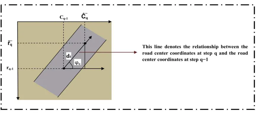
= q q q q q c r y ϕ ϕ & (4)
Where rq-is the row number of the center of the
road, cqis the column number of the center of the
road, ϕqis the road direction and ϕ&qis the change
[image:6.595.88.522.348.541.2]in direction or road curvature in the qthstep.
Fig 2: Graphical illustration of the evolution of the coordinates of the road model from one step to the next
With the help of Fig 2, the system equation is created as follows:
q q q q q q q q q q q q q q q w dt dt dt c dt dt r c r y + + + + + − = = − − − − − − − − − 1 1 1 1 1 1 1 1 1 ) cos( . ) sin( . ϕ ϕ ϕ ϕ ϕ ϕ ϕ ϕ ϕ & & & & & (5)
5.2.2 Profile matching:
Once identify the road path used UKF, the profile matching process is done by Euclidean distance between the corresponding updated profile and reference profile. Here, we have given to some
thresholdT. During the matching process is higher than the threshold T, the UKF’s road tracking process stop, then GHKF takes the control of the road extraction process and regains track of the road or possibly road branches on the other side of a road junction or obstacle.
5.3 Road extraction algorithm
• UKF phase:
This phase is initialized with a seed point given at the starting of the road extraction process. The beginning point contains coordinates of the road center and direction of the road at that point. The road center coordinates and road direction are considered as the initial state of the proposed system, called
y
1. This starting point is employed to initialize the grid based clustering technique. The UKF phase begins tracking the road using starting start and initial grid based cluster.When the UKF phase visits a severe obstacle on the road path or arrives at a road junction, the matching process cannot successfully generate next prediction state. An update profile is extracted from the observation model. This profile is compared with reference profile. In this stage, we have assigned some predefined threshold for the road region, and this threshold is based on the RGB image. If the prediction is above the threshold and the UKF stops and passes the control to the GHKF phase. In this case, the GHKF makes another state update based on the current position, so as the estimation position is jumped over. When multiple jumps occurs, the Gauss-Hermite Kalman Filter identifies it as a tracking failure and return control back to the Unscented Kalman Filter.
Prediction stage:
We first choose, M sample points Yqi−1 and
their weightswiq
1
− , i=0, 1…N-1. These sample points capture the true mean and covariance of the density function and hence approximate the true density function up to the second order statistics.
) ( 1 1 1 i q q i q
q f y
Y
− − − =
These samples denotes the predicted density
) ( 1 − z q x
p and its means and covariance is given
by i q q N i i q
q wY
y 1 1 0 1 ˆ − − = − =
∑
T q q i q q q q N i i q q i qq w Y y Y y
P [ ˆ 1][ 1 ˆ 1]
1
0
1
1 − − −
− =
−
− =
∑
− −Therefore,p(xq z−1)is estimated by assuming
that is distributed as N(xˆqq−1,Pqq−1)at the end of
the prediction stage. Then, the predicted measurement vector is calculated as below:
) ( ˆ 1 0 1 1
∑
− = − − = N i i q q i qq w hY
z
After prediction stage, all predictions have gone to be updated using the observation obtained in the
th
q
step, calledz
q.Update stage: ) ˆ ( ˆ ˆ 1 1 − − + −
= qq q q qq q
q y K z z
y T q q q q q q
q P K S K
P = −
−1
Here,
K
q is the kalman gain andS
qinnovationcovariance matrices and these are computed as following formulas:
1
−
= uv q q P S
K
vv q
q R P
S = +
Where T k k N i i q q q q i q q i
uv w Y y hY z
P ( ˆ )( ( ) ˆ 1)
1 0 1 1 1 − − = − − − − − =
∑
T k k N i i q q q q i q q ivv w Y z hY z
P ( ˆ )( ( ) ˆ 1)
1 0 1 1 1 − − = − − − − − =
∑
• GHKF phase:
To initialize the GHKF phase, the UKF phase relocates the information about its last successful step of the present road segment onto the GHKF phase. The GHKF [16] begins its work with a single road branch by using the last successful state estimate of the UKF phase as its initial state
1
y
.Prediction stage:
• Find the rootyi,i=1,...p, of the Hermite polynomialHp(y).
• Compute the corresponding weights
2 1 2 1 )] ( [ ! 2 i p p i y H p p w − − =
• Use the product rule to expand the points
to a
n
dimensional lattice of np pointsξi,i=1,...,pn, with corresponding weights.
• Propagate the cubature points. The matrix
1 1 1 1 1 1
,q− q− = 2 q− q− i+ q− q−
i P m
Y ξ
• Evaluate the cubature points with the
dynamic model function
) ( , 1 1
* 1
,qq− = iq− q−
i f Y
Y
• Estimate the predicted state mean
∑
= − − = n p i q q i i qq wY
m 1 * 1 , 1
• Estimate the predicted error covariance
∑
= − − − − − − = − + n p i q T q q q q T q q i q q i i qq wY Y m m Q
P 1 1 1 1 1 , * 1 , 1
6. RESULT AND DISCUSSION
This section presents the results obtained from the experimentation and its detailed discussion about the results. The proposed approach of road extraction technique is experimented with the satellite image dataset and the result is evaluated with the sensitivity, specificity and accuracy.
6.1 Dataset description:
The proposed technique is performed in a windows machine having configurations Intel (R) Core i5 processor, 3.20 GHz, 4 GB RAM, and the operating system platform is Microsoft Wnidow7 Professional. We have used mat lab latest version (7.12) for this proposed technique.
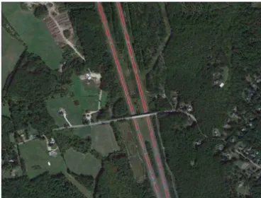
[image:8.595.119.481.360.468.2]In this technique, we have used satellite road images and this satellite image collected through internet. Below Fig 3 shows road area satellite images.
Fig. 3. Input Satellite Images
6.2 Evaluation metrics
The evaluation of proposed technique in different satellite images are carried out using the following metrics as suggested by below equations, Sensitivity = negatives false of number positives true of number positives true of number + Specificity = positives false of number negatives true of number negatives true of number + Accuracy= positives false negatives true negatives false positives true of number negatives true of number positives true of number + + + +
6.3 Experimental Results
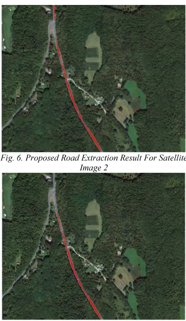
The proposed technique is designed for road area extraction in satellite images. Here, we have taken three images results for this section. The obtained experimental results from the proposed
technique are given in Fig 4 and 9. Fig 4, 6 and 8, shows proposed road extraction image. Fig 5, 7 and 9 shows existing road extraction technique. Here, we have taken extended kalman filter and particle filter for existing technique [1].
[image:8.595.315.499.569.709.2]Fig. 5. Existing Road Extraction Result For Satellite Image 1
Fig. 6. Proposed Road Extraction Result For Satellite Image 2
[image:9.595.93.281.305.629.2]Fig. 7. Existing Road Extraction Result For Satellite Image 2
Fig.8. Proposed Road Extraction Result For Satellite Image 3
Fig. 9. Existing Road Extraction Result For Satellite Image 3
6.4 Performances evaluation
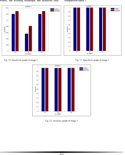
In this section, we describe the performance evaluation and comparative analysis of proposed approach with existing technique. Here, we have taken extended kalman filter and particle filter for existing technique [1]. The performance analysis has been made by plotting the graphs of evaluation
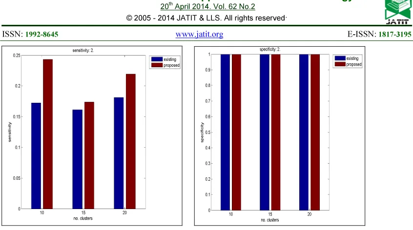
[image:9.595.316.499.321.464.2]about 98.085% where, the existing technique has achieved only 98.065% for cluster 10. In Fig 10, the sensitivity is achieved 22.591, where, the existing technique has achieved only 21.764 for cluster 10. For image 2, the performance graphs are plotted and they are given in Fig 13 and 15. In Fig 15, the proposed technique is achieved the accuracy of about 98.452% where, the existing technique has achieved only 98.307% for cluster 10. In Fig 13, the sensitivity is achieved 24.336, where, the existing technique has achieved only
17.265 for cluster 10. For image 3, the performance graphs are plotted and they are given in Fig 16 and 18. In Fig 18, the proposed technique is achieved the accuracy of about 98.220% where, the existing technique has achieved only 98.168% for cluster 10. In Fig 16, the sensitivity is achieved 69.469, where, the existing technique has achieved only 65.019 for cluster 10. Totally, the proposed road area extraction technique is proved better results when compared existing technique from the comparison table 1.
[image:10.595.88.514.243.770.2]
Fig. 10. Sensitivity graph of image 1 Fig. 11: Specificity graph of image 1
[image:10.595.94.505.261.434.2] [image:10.595.178.416.267.640.2] [image:10.595.195.402.451.639.2][image:11.595.81.519.62.789.2]
Fig. 13.Sensitivity graph of image 2 Fig. 14.Specificity graph of image 2
Fig. 15. Accuracy graph of image 2
[image:11.595.86.509.80.316.2]Fig. 16. Sensitivity graph of image 3 Fig. 17. Specificity graph of image 3
Fig. 18. Accuracy graph of image 3
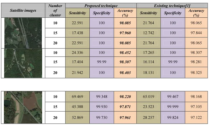
Table I
Comparison Table Of Proposed Technique Against Existing Technique
Satellite images
Number of cluster
Proposed technique Existing technique[1]
Sensitivity Specificity Accuracy
(%) Sensitivity Specificity
Accuracy (%)
10 22.591 100 98.085 21.764 100 98.065
15 17.438 100 97.960 12.742 100 97.844
20 22.591 100 98.085 21.764 100 98.065
10 24.336 100 98.452 17.265 100 98.307
15 17.404 99.99 98.307 16.114 99.99 98.281
20 21.942 100 98.403 18.131 100 98.325
10 69.469 99.348 98.220 65.019 99.467 98.168
15 45.388 99.930 97.871 23.523 99.999 97.105
20 52.869 99.730 97.961 28.257 99.824 97.122
7. CONCLUSION
In this paper, we have proposed a road map extraction system with two efficient filters using satellite images. Here, Unscented Kalman filter and Gauss-Hermite Kalman Filter are utilized to trace and identify various connected road paths and to avoid obstacles under diverse conditions. Up to a time that it falls to a severe obstacle or an
case of unpainted road line and real traffic conditions, reduction algorithm technique will be explored.
REFERENCES
[1] Movaghati, S., Moghaddamjoo, A., Tavakoli, A, “Road Extraction From Satellite Images Using Particle Filtering and Extended Kalman Filtering", IEEE Transactions on Geoscience and Remote Sensing, Vol. 48, No: 7, pp: 2807-2817, 2010.
[2] G. Vosselman and J.D. Knecht, “Road tracing by profile matching and Kalman filtering,” in Proc. Workshop Autom, “Extraction Man-Made Objects Aerial Spaxe Images,” Birkhaeuser, Germany, pp.265-274,1995. [3] A.Baumgatner, S.Hinz, and C.Wiedemann,
“Efficient methods and interfaces for road tracking,” in Proc. Int. Arch. Photogramm. Remote Sens., vol.34.pp 28-31, 2002.
[4] J.Zhou. W.F.Bischof, and T. Caelli, “Road tracking in aerial images based on human-computer interaction and Bayesian filtering,” ISPRS J. Photogramm. Remote Sens., vol.61, no.2, pp. 108-124, 2006.
[5] J.Zhou, W.F.Bischof, and T.Caelli, “Robust and efficient road tracking in aerial images,” in Proc. Joint Workshop ISPRS and DAGM (CMRT) object Extraction 3D City Models, Road Databases Traffic Monitoring-Concepts, Algorithms Evaluation, Vienna, Austria, pp.35-40, 2005.
[6] M.Bicego, S. Dalfini, G.Vernazza, and V.Murino, “Automatic road extraction from aerial images by probabilistic contour tracking,” in Proc ICIP, pp.585-588, 2003. [7] Asif, Muhammad; Arshad, Mohd Rizal;
Muhammad Yousuf Irfan Zia; Yahya, Abid, "An Implementation of Active Contour and Kalman Filter for Road Tracking ,"International Journal of Applied Mathematics,Vol.37,No.2,pp.71,2007. [8] Jiuxiang Hu, Anshuman Razdan, John C.
Femiani, Ming Cui, and Peter Wonka, "Road Network Extraction and Intersection Detection From Aerial Images by Tracking Road Footprints, "IEEE Transactions On Geoscience And Remote Sensing, Vol. 45, No. 12, December 2007.
[9] P.N. Anil and Dr. S. Natarajan, "Automatic Road Extraction from High Resolution Imagery Based On Statistical Region Merging and Skeletonization, "International Journal of
Engineering Science and Technology, Vol. 2,No.3,pp.165-171,2010.
[10] Aleksey Boyko, Thomas Funkhouser,” Extracting roads from dense point clouds in large scale urban environment,” ISPRS Journal of Photogrammetry and Remote Sensing, Vol.66, 2011.
[11] Saurav Jyothi, Dhruba K.Bhattacharya,” A Grid Density Based Technique For Finding Clusters in Satellite Images,” Elsevier Pattern Recognition Letters, May 2011.
[12] G. Vosselman and J. D. Knecht, “Road tracing by profile matching and Kalman filtering,” inProc. Workshop Autom. Extraction Man-Made Objects Aerial Space Images, Birkhaeuser, Germany, pp. 265-274.1995.
[13] A. Baumgartner, S. Hinz, and C. Wiedemann, “Efficient methods and interfaces for road tracking,” in Proc. Int. Arch. Photogramm. Remote Sens., vol. 34, pp. 28-31, 2002. [14] J. Zhou, W. F. Bischof, and T. Caelli, “Road
tracking in aerial images based on human-computer interaction and Bayesian filtering,”ISPRS J. Photogramm. Remote Sens., vol. 61, no. 2, pp. 108-124, 2006.
[15] Sahar Movaghati,Alireza
Moghaddamjoo,Ahad Tavakoli, "Using Unscented Kalman Filter for Road Tracing From Satellite Images, "IEEE Second Asia International Conference on Modelling & Simulation,2008.
[16] Goutam Chalasani,Shovan Bhaumik, "Bearing Only Tracking Using Gauss-Hermite Filter," 7th IEEE Conference on Industrial Electronics and Applications (ICIEA),pp.1549-1554,2012. [17] F.Benkoudier, L.Hamam and A.Abdellaoui,” Use of Neural Net for Road Extraction from Satellite Images,” Progress in Electromagnetic Research symposium Proceedings, March 2011.
[18] D.Chaudri, N.K.Kushwaha and A.Samal,” Semi Automated Road Detection From High Resolution Satellite Images by Direction
Morphological Enhancement And
Segmentation Techniques,” IEEE Journal of Selected Topics in Applied Earth Observations and Remote Sensing, October 2012.
[19] M.Rajeswari,” Automatic Road Extraction based on level set normalized cuts and mean shift methods,” International journal of computer science, May 2011.
formation,” International journal of Computer Application, September 2011.
[21] T.Rajani Mangala,S.G Bhirud,” Road Network Extraction from resolution satellite images based on LSE-LBF model,” International Journal Of Scientific & Engineering Research, October 2011.
[22] P.N.Anil, Dr.S.Natarajan,” Automatic Road Extraction from High Resolution Imagery Based on Statistical Region Merging AND skeletonisation,” International journal of Engineering science and technology, May 2010.
[23] P.N.Anil, Rizvi and B.Krishna Mohanam,” Object-Oriented Method for Automatic Extraction of Road from High Resolution Satellite Images,” Iranian Journal of Earth Science, Feb 2010.
[24] Aleksey Boyko,Thomas Funkhouser,” Extracting Road FROM Dense Point Clouds In Large Scale Urban Environment,” Elsevier ,Journal of Photogrammetry And Remote Sensing, 2011.
[25] Rohit Maurya, Dr. Shalini Singh, Dr. P.R Gupta, and Manish Kumar Sharma,” Road Extraction Using K-Means Clustering and Morphological Operations,” International journal of advanced engineering sciences and technologies, Vol. 5, No. 2,pp.290-295,2011
[26] M. Abdellaoui, A. Douik, K.
Besbes,"Tracking and Analyzing Human Motion in Video "Body tracking, Points of interest, Human motion analysis,"Vol. 4. n. 6, pp. 640-647,November 2009.
[27] Bouchiha Rochdi, Besbes