Using geocaching as a teaching tool with student architects
Dr. Alexander GriffinUniversity of Huddersfield
Introduction
Geocaching is a global positioning system (GPS) based treasure hunt game that is played throughout the world. Participants find hidden containers, called geocaches, using GPS coordinates and then share their experiences online.
The inherent manipulability of the game enables those who choose to plant geocaches to introduce site-specific information, which can lead to a multitude of participant experiences, making the game a flexible and informative learning exercise.
At the University of Huddersfield School of Art, Design and Architecture (SoADA), geocaching has been used for many years as a teaching tool allowing students to investigate a variety of places at a tangible level and analyse a site’s complexities in preparation for contextually responsive design projects. An important part of a student’s measurable outcome and reflection process in response to the geocaching exercise is the production of a Site Investigation Report. This resource captures a student’s experiential and emotional responses towards a place and forms an important briefing document for a conjoining subsequent contextual design project.
An important pursuit that geocaching fosters is a site-specific design response with a sustainable emphasis. When the notion of sustainable architecture is stripped of all the measuring processes, (which in many cases have diluted the important concern for the well-being of our world and the people who live on it into a collection of detracting and often irrelevant details for the purposes of ‘easy measurement’), we find that what remains are beauty and appropriateness. Sustainable architecture is at its core, architecture that people want to sustain. The primary purpose for utilising geocaching as a teaching tool at SoADA is to further assist students to gain a deep
understanding of context so as to produce site-specific sustainable design projects that people would want to keep.
This paper will describe how geocaching is used as an engaging online teaching tool that enables students to undertake physical site investigation and analysis as part of their study of both actual and metaphorical places in preparation for sustainably assertive design projects.
Since geocaching was introduced into the teaching programme within the Year 1 architecture course, a SoADA Geocaching Document has been produced. With reference to this resource and student experiences, this paper will describe how many students have used geocaching as a means to enhance a concern for places, people and the design of sustainably appropriate architecture.
Geocaching
The game of geocaching started in May 2000, when the U.S. government turned off Selective Availability, a feature that limited the accuracy of GPS signals for civilians for national security reasons. Within 24 hours the first geocache had been placed and its coordinates were posted online. Today there are over 2,000,000 geocaches worldwide and 6,000,000 geocachers.
The principal aim of geocaching is to enable participants to find hidden containers or virtual points called geocaches using GPS coordinates and then share experiences online. The game is often played in areas of natural beauty or interest and many geocaches contain information relating to the area, especially where the area is geographically or geologically significant. Once a new participant has registered their membership, the next step is simply to find which geocaches are nearby. To visit a geocache is simple with a GPS enabled mobile device; just select the geocache via the app and it will navigate with an inbuilt compass or map. The app also provides helpful information regarding the terrain, the size of the geocache, how difficult it should be to find, etc. What participants are looking for varies; geocaches come in different types, sizes and disguises. Some geocaches can be easily found; others are very well hidden or difficult to retrieve. Many of the larger geocache containers have within them small toys, which can be taken if replaced with something of equal value.2 The only other rules that apply to finding a geocache are, participants must write their name on a log, contained in every geocache, and they are then required to notify the geocaching community of their find by contributing a comment of their experience at Geocaching.com.
Geocaches can be planted by anyone, although participants are required to adhere to a comprehensive set of regulations specified at Geocaching.com3 so as to avoid
trespass or endangering the environment and enable fair play. Many geocaches have been hidden in remote areas or placed in such a manner that they are difficult to retrieve. Perhaps the geocache most difficult to retrieve is the one that is magnetically attached to the International Space Station travelling at 17000 mph at an altitude of 250 miles.4 Other efforts to make retrieval more taxing include submerging geocaches in water and constructing containers that require specialist equipment to be opened.5 Many geocaches require participants to solve a puzzle before the geocache’s coordinates are revealed. Some geocaches can only be found by first finding clues that are themselves within geocaches; thus, one find can lead to a string of further discoveries.
[image:2.612.341.558.92.251.2]
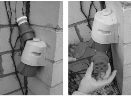
Fig. 1 & 2. A geocache disguised as a fake light bulb (left) and a geocache disguised as a bolt (right).
Fig. 3. A geocache disguised as a discarded bottle cap.
[image:2.612.341.557.298.462.2] [image:2.612.342.556.498.656.2]
For a nominal membership fee participants can purchase a Premium Membership, which comes with a collection of benefits including access to members only geocaches and alerts for new geocaches as and when they are released; the sport includes many who join a race to be the first to find (FTF) a new geocache. There is no reward for a FTF except for the admiration of fellow players.
Learning context by geocaching
The use of geocaching as a teaching tool has been an important part of the Year 1 programme at SoADA for many years because it embodies a central theme of the course; namely, to design architecture in response to place. Furthermore, the exercise incorporates group study, it is student led with tutor guidance, and enshrines an assertive sustainable approach to the design process by prioritising contextual and social understanding. The outcome of the geocaching led site investigation and analysis is then used to form the basis of the primary design project, a bothy that stands within Butterley reservoir. Collectively, and including other relevant exercises, the geocaching and bothy projects are the lion’s share of an important 40 credit module which students embark upon at the very start of their academic educational training at Huddersfield.
The primary benefit of the geocaching exercise is that it leads students to explore socially and environmentally focused agendas of their own choosing as they progress with their bothy design project. The geocaching exercise; however, consciously avoids prescribing a stylistic approach, allowing students to present a variety of architectural responses. The only strong advice given by tutors at an early stage is that design proposals should avoid pastiche and replicating the traditional Yorkshire rural bothy mould.
All too often an architectural site study involves little more than a trip to a site with a camera. This is generally followed by an Internet search to collate reams of data that is at best, vaguely useful. The result of this approach is a contrived and impersonal understanding of a context. The geocaching exercise seeks to avoid this ‘easy’ form of surface deep information gathering.
A SoADA Geocaching Document has been produced which pulls together a ‘get started guide’, a series of detailed
maps and aerial photographs for students without GPS enabled mobile devices, a complete list of required equipment and clothing suitable for hiking in the Peaks, and a full description of other module requirements such as learning outcomes and safety information.
The Geocaching Document outlines the benefits of geocaching as a means to help in the investigation of place and makes explicit the skills students can develop by partaking in the exercise within the wider context of architectural education. Specifically, the document describes two core skills that students are enabled to develop; namely, contextual investigation skills (acquiring and prioritising information relevant to a place and in preparation for a design project; presenting information at tutorials and reviews), and team skills (managing expectations and requirements collectively, and apportioning work commitments). Incumbent within these skills are critical thinking and reflection at tutorial sessions and all inclusive studio reviews.
These skill sets seek to imbue responses that address the important social and environment ethos at SoADA. The rural nature and natural beauty of the site is conducive for a concern for environmental consideration; therefore, a emphasis in the Geocaching Document is placed on attaining a social agenda by means of requiring students to consider the design of the bothy for a particular person at an early stage in the investigation process. By being explicit in describing the learning opportunities to be gained through geocaching, students are equipped to respond to social and environmental challenges in the designing of architecture and are made aware of the importance of contextual appropriateness; a vital and transferable skill for students from all nationalities.
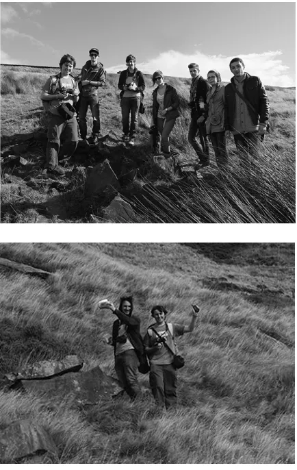
Fig. 6. Geocaches in the Northern area of the Peak District near Marsden. These geocaches form a series; once all the geocaches have been retrieved, clues from each geocache lead to a further bonus geocache.
After a preparation session in the studio where relevant maps and geocaching information are gathered, students are required to rendezvous with staff at a set departure location on the outskirts of Marsden. Small groups of around 4-6 students then set off in search of the geocaches. Some students take the hunting game as an opportunity to race against each other in a Bear Grylls-like fashion and aim to break the all time record set by a fell running student.
The exercise generally takes place in October, though many students return to the area during the subsequent months. The search for geocaches draws students to remote and sometimes austere parts of the North White Peaks; the geocaches have been strategically placed on hilltops, in rocky crevices and caves, and in remote outlying marshlands.
Students are required to fumble in the bracken, walk off the well-trod tracks and experience the inimical environment. The search leads students to protected valleys and exposed windswept rock escarpments. Students who have chosen to ignore the requirement for appropriate footwear and clothing soon discover that the Peaks can be muddy, cold and very uncomfortable in plimsolls. The exercise is finished with a rewarding excursion to one of Marsden’s pubs or coffee house.
Fig. 7 & 8. Students on the hunt for geocaches.
[image:4.612.90.307.93.259.2] [image:4.612.342.557.469.631.2]If a student chooses to visit the area on a number of occasions then they will also invariable notice the change in climate from one day to the next. Some of the braver students have ventured into the Peaks after snow has settled; when overcast, the White Peaks can be a hostile and unforgiving place where shelter is in short supply and other than hikers following the Pennine Trail, company is sparse.
Whilst students are walking (or running) from one geocache to the next they are encouraged to consider how to capture their experiences. Sound recording equipment is used to capture the constant noise of rushing wind over exposed escarpment faces and the ubiquitous sketchpad and camera are taken to record feelings more than observations.
[image:5.612.343.558.92.247.2]The Geocaching Documents explains that the exercise is a prelude to a project involving the design of a bothy. The bothies are required to be located within the Butterley reservoir 5m from the shoreline, but at a location determined by the student. These bothies are to be placed on a 3x3m concrete pad that protrudes from the water surface by 1m. Each bothy is to be designed for a specific person of the student’s choice (either a real person or a clearly defined refabricated person). These confines prompt students to grapple with social and anthropometrical restraints and the very practical need to provide shelter in a diverse and sometimes uncomfortable environment.
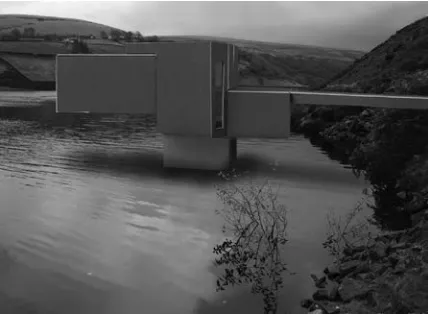
[image:5.612.90.304.499.656.2]Fig. 10. Bothy project designed in specific response to the context. The elongated form points towards a view of a water gate tower that strides a dam.
Fig. 11. Bothy project shown in context.
Conclusion
Geocaching forms an important contribution to the Year 1 architecture course at SoARA and is used as a teaching tool with the specific aim to engender a contextually focussed social and environmental awareness within architectural design.
The geocaching exercise has developed over the years from a simple solitary local geocache to a concatenation of geocaches around Butterley reservoir that are used today. The exercise is often followed by positive feedback and a sense of achievement on the part of students. Students often repeatedly return to the site to find further local geocaches and, in so doing, experience the place during different weather patterns. The success of the project is noticeable to the degree to which the Year 1 students feedback a sense of belonging to their new Yorkshire home, and the bothy projects have displayed a far greater sense of contextualisation since the introduction of geocaching.
In conjunction with this paper, a geocaching architectural tour will be devised in time for the 2014 AAE conference in Sheffield. This tour will bring participants to a number of places and buildings of architectural interest within walking distance of the conference, and will seek to provide an experiential and enjoyable demonstration of the learning benefits on offer through geocaching.
Notes
1 www.geocaching.com Geoaching.com has a very useful set of
introductory instructions and movies for the novice, together with further information for the more dedicated geocacher.
2 At this stage I should declare that I have more than a casual
interest in geocaching and that I am in fact a rather devout follower. I’m not ashamed to admit that. This admission also permits me to share a few personal geocaching stories. There is a geocache in the outlying suburban area to the north of Leeds that is regularly stocked with sherbet liquorice sweets. It is a temptation to find this particular geocache on a regular occasion. Another welcoming find was a pack of plasters in a geocache that was hidden in a South African rocky desert and only retrievable by means of a very long hike.
3 www.geocaching.com/about/hiding.aspx
4 Currently only the American Space Shuttle and Russian Soyuz
vehicles can reach the ISS. This will be changing soon, not only is the shuttle retiring, but there is a fleet of private space vehicles due to be brought into commission that will perhaps enable the geocache to be more regularly discovered.
5 I recall on one occasion retrieving a magnetic geocache that was