2016 International Conference on Artificial Intelligence: Techniques and Applications (AITA 2016) ISBN: 978-1-60595-389-2
A Dynamic Hop Choosing Mechanism for Routing in VANETs
De-ling HUANG
1,2,*, Chang SU
1, Yu-song YAN
2and Guang-xia XU
11College of Software Engineering, Chongqing University of Posts and Telecommunications,
Chongqing 400065, China
2College of Information Science and Technology, Southwest Jiaotong University, Chengdu 610031,
Sichuan, China
*Corresponding author
Keywords: VANET, Position-based, Routing.
Abstract. Routing in VANETs is challenging because of the frequently changed topology. The dynamic nature is caused by the high speed mobility of vehicles as nodes in the network. Adapting the dynamic topology is the main task during routing in VANETs. Fortunately, the mobility patterns and positons of vehicles in vehicular networks are predicable. Making advantage of these characteristics, this paper presents an improved dynamic hop choosing mechanism. It not only predicts the positions and mobility patterns of vehicles, but also takes into account the vehicular traffic density. Accordingly, the next hop chosen by our mechanism is seldom out of reach even if the topology is quickly changed. Simulation results exhibit that the proposed algorithm improves the packet delivery ratio and reduces the network latency when compared with state of the art protocols.
Introduction
Vehicular Ad hoc Networks (VANETs) is a kind of mobile ad hoc networks, nodes in which are vehicles, providing inter-vehicle communication. There are kinds of ways for vehicles to communicate with each other. They can either use infrastructure or not. VANETs are self-organized networks which can run without any prior infrastructure. Especially in some extreme situation, where it’s hard to deploy any infrastructure, this infrastructure-free characteristic of VANETs is valuable.
IEEE 802 committee published a wireless communication standard for wireless access in the vehicular environment, i.e. IEEE802.11p in 2010. It will be used with dedicated short range communication system, which is suitable for VANETs and works well for vehicle-to-vehicle communication and vehicle-to-infrastructure communication. Besides these works, routing in VANETs is still a challenging task due to the high vehicular mobility and frequently changed topology.
The rest of the paper is organized as follows. Section 2 explains the position-based routing protocols. In section 3, we detail our design scheme of node selection mechanism based on node’s position and directional dense. Section 4 verifies the efficiency of our proposed algorithm through the simulation results. In section 5, we conclude this paper and present the future work.
Related Work
In recent years, the position-based routing protocol are widely concerned by researchers. At present, lots of position-based routing algorithms for VANETs have been proposed, such as Greedy Perimeter Stateless Routing (GPSR)[2] based on pure greedy forwarding, Geographic Source Routing (GSR)[3] base on the supporting from a map of the city, Improved greedy traffic aware routing protocol (GyTAR)[4] based on the dynamic junction selection mechanism, and Enhanced GyTAR (E-GyTAR)[5] which enhanced the junction selection mechanism.
E-GyTAR is an enhanced version of GyTAR. It is designed for routing in city environment. It assume that vehicles in the discussing network have GPS devices, location services, digital maps, and IFTIS on board. Vehicles can get their own geographic positions though GPS devices, get the ultimate destination’s position though location service such as Grid Location Services (GLS)[6] . Digital maps can provide the position information of the junctions in the city. IFTIS[7] is the Infrastructure-free traffic information system used to calculate the real time vehicular density between adjacent junctions. As nodes in VANETs can always get sufficient power supply and processing capacity, these assumptions are reasonable.
In city scenario, vehicles move along streets. Hence any route can be presented by a series of junctions. And the core job of determine a route lies on the junction selection. In E-GyTAR, junctions constituting the route are selected dynamically. Each candidate junction are scored according to the directional density[7] and geographic positon. Forwarding vehicles measure the distance between the candidate neighbor junction and the destination using Eq. 1.
score(Nj) = 𝛼 × (1 −𝐷𝑛
𝐷𝑐) + 𝛽 × 𝐷𝑒𝑛𝐷𝑖𝑟
(1) where Dn is the curvemetric distance (the distance measured following the geometric shape of the
roads passing by) between the candidate junction Nj and the destination; Dc is the curvemetric
distance from the current junction to the destination; DenDir is the total number of vehicles between
current junction and next candidate junction moving towards Nj, which represents the directional
density; α and β are the weighing factor for the distance and traffic density respectively, and add up to 1.
The candidate junction with the highest score is selected as the next junction every time the packet arrived at a junction or the source starts finding the first junction. As for routing between the two involved junctions, E-GyTAR uses improved greedy approach. Before relaying packet, a forwarder consults its neighbor table to find out a best next hop at that moment.
There is still one risk, that E-GyTAR sometimes may suffer from local maximum problem (the forwarder is the closest to the next destination junction). It exploits carry and forward[6] approach as a recovery strategy. The forwarder will carry the packet until it arrived at the next destination junction or until another node closer to the next destination junction enter into its transmission range.
ITAR- Dynamic Traffic Aware Routing
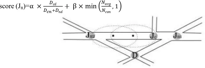
Next Junction Selection. When we score the neighbor junctions, the curvemetric is the core factor, but not the ratio mentioned in E-GyTAR. Considering the scenario in Fig. 1, score of junction Jn2 is larger than the score of junction Jn1if we use Eq. 1. That means Jn2will be chosen as the next
junction, which is obviously wrong. Considering Jc can directly relay the packet to Jn1, but need 2 more hops when relay packets to Jn2, junction Jn1 should be chosen. We redesign the junction
selection algorithm as followed:
Algorithm 1. Pseudo code for junction selection mechanism in ITAR For (all candidate junctions Jn ){
D := the destination ; Jc := the current junction;
Jn := the next candidate junction;
Dcd := the Euclidean distance between Jc and D; Dnd := the curvemetric distance from Jn to D; Dcn := the curvemetric distance from Jc to Jn; Navg:= average number of vehicles per cell;
Ncon := constant which represents the ideal connectivity degree we can have within a cell; between Jc and Jn moving in the direction of Jn;
calculate score (Jn) using Eq.2 with α + β=1;}
score (Jn)=α × 𝐷𝑐𝑑
𝐷𝑐𝑛+𝐷𝑛𝑑+ β × min ( 𝑁𝑎𝑣𝑔 𝑁𝑐𝑜𝑛
[image:3.595.72.419.338.453.2], 1) (2)
Figure 1. Junction selection mechanism.
The junction with the highest score is selected as the next junction. This selecting mechanism takes into account both the junction’s position and the consideration of vehicular traffic on the street.
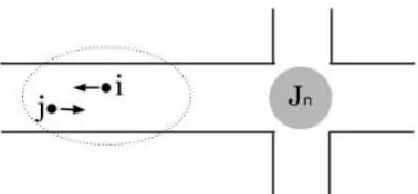
Recovery Mode. There are still risk that packet gets stuck in local optimum. E-GyTAR and other position-based routing algorithms adopt unconditional carry and forward approach as the recovery strategy. However, considering the situation in Fig. 2, this strategy may result in unnecessary packet dropping sometimes. As in Fig.2, node i find itself the local optimal node, and it will carry the packet rather than forward it to node j. In fact, node j will be closer than node i to the destination junction a few moment later. But if note i doesn’t calculate, it won’t know this potential candidate forwarder. In ITAR, when packet gets stuck in local maximum, the node immediately score itself and its neighbors, and choose the one with the highest score to pass on the packet to. Eq. 3 presents how to score every node, including the node doing the calculation and its one hop neighbors.
score (N)=m[γ(1-d/L)+ λ(v/vmax)] (3) where d is the distance between the node and the junction, v is the velocity of the node, L and vmax are
Figure 2. Enhanced carry and forward.
Simulation
[image:4.595.208.387.297.444.2]We compared the performances of ITAR with state of the art protocols. The experiments were conducted on NS-2 simulator. Medium access control (MAC) is IEEE 802.11p, with a radio range of 260m. The mobility traces were generated using VANetMobiSim with the micro-mobility controlled by IDM_IM. Table 1 illustrates the simulation setup.
Table 1. Simulation Parameters.
Parameter Value
Simulation time 200s
Dimension 2500m ×2000m
Number of intersection 16
Number of roads 24
Number of vehicles 100-300 Average vehicle speed 45Km/h Transmission Range 250
Packet sending rate 0.1-1 second
Packet size 128 byte
Weighting fators (α ; β) (0.5 ; 0.5) Weighting fators (γ;λ) (0.5 ; 0.5)
Effect on Packet Delivery Ratio. Fig.3 illustrates the packet delivery ratio increases as the traffic density increases. This is because the probability of connectivity will be higher in higher traffic density. It also proves that why our proposed node choosing strategy take into account the vehicular traffic density. ITAR shows better in PDR, because of the enhanced recovery mode it adopts. Wrong carrying decision of other protocols will contribute to the packet loss rate.
Effect on Average Latencies. Fig.4 shows that ITAR overcomes the other three protocols in network average latencies. This is because the junction selection mechanism of ITAR is the most reasonable. As is discussed in section 3, the next junction selection algorithm always chooses the candidate junction closest to destination, and in the meantime it’s also the closest to the current junction. This always make the route with fewer forwarding hops and consequent smaller latency.
[image:4.595.59.541.626.745.2]hop choosing algorithm which result in smaller communication traffic and higher PDR than the other two.
Summary
This work aims at improving the routing efficiency in vehicular ad-hot networks. The simulation results have proved the proposed scheme adapts itself well to VANETs in varying vehicular traffic. The proposed algorithms has improved the delivery ratio and reduced the network latencies in different node density compared with some other routing protocols. We are currently extending this work. We will try to analyze the impact of the weighting factors used for node score calculation in the future.
Acknowledgement
This research was financially supported by the National Natural Science Foundation of China (Grant No. 61309032, No.61272400), Program for Innovation Team Building at Institutions of Higher Education in Chongqing (Grant No.KJTD201310), China Postdoctoral Fund (No. 2014M562282), the Project Postdoctoral Supported in Chongqing (No. Xm2014039), Scientific and Technological Research Program of Chongqing Municipal Education Commission (KJ1400431, KJ130508).
References
[1] S.M.B., C.J. Bernardos, and C. Guerrero, Position-based routing in vehicular networks: A survey. Journal of Network and Computer Applications, 2013. 36: pp. 685-697.
[2] Karp, B. and H.T. Kung. GPSR: greedy perimeter stateless routing for wireless networks. International Conference on Mobile Computing and NETWORKING. 2000.
[3] Lochert, C., et al. A routing strategy for vehicular ad hoc networks in city environments. Intelligent Vehicles Symposium, 2003. Proceedings. IEEE. 2003.
[4] Jerbi, M., et al., An Improved Vehicular Ad Hoc Routing Protocol for City Environments. Communications .icc ’07.ieee International Conference on, 2007: pp. 3972-3979.
[5] Bilal, S., S.A. Madani, and I. Khan, Enhanced junction selection mechanism for routing protocol in VANETs. International Arab Journal of Information Technology, 2011. 8(4): pp. 422-429.
[6] Li, J., A scalable location service for geographic ad hoc routing. Proc Acm/ieee Mobicom, 2001: pp. 120-130.