GIS
USING
ZIGBEE
1
K.SREE GANESHAN,
2P.SRAYAS,
3E.SRI BALAJI,
4Mrs.M.MERCY THERESA
1,2,3 Student, Department of Electronics and Communication Engineering,
JEPPIAAR SRR Engineering College, Old Mamallapuram road, I.T. Highway, Padur, Chennai – 603103
4Assistant Professor, Department of Electronics and Communication Engineering,
JEPPIAAR SRR Engineering College, Old Mamallapuram road, I.T. Highway, Padur, Chennai – 603103
---***--- ABSTRACT - Communication systems during disaster
relief operations are crucial. GIS stands for Geographic Information System. The wireless systems are expected to perform at their best in hostile conditions with limited resources since thousands of lives are at stake. This project proposes a balloon-borne zigbee technologies that enables the delivery of wireless services in geographic area that are not served or are poorly served by existing technologies. In our Proposed system we presents a generic approach for geo fencing by requesting citizens and volunteers to help authorities formulate a greater situation awareness of region under consideration. The geo fences are visualised to provide a good overview of the disaster zone. This intends to improve the fast response and resolution of majority of the problems that emerge from a disaster. It holds electronic devices like circuit boards, Zigbee, solar panels, batteries, GPS and weather monitoring devices. Camera (High Intensity Vision Cam) is used to take the images frequently in the coverage area. A geo-fence could be dynamically generated as in a radius around a store or point location. With continuous enlarging of exploiting areas and extension of depth in coal mine, many laneways become monitoring blind areas, where are lots of hidden dangers. This project presents the design and implementation of a continuous monitoring device to measure the physiological variables of miners at high altitudes with wireless communication, safety monitoring.
Key Words – Balloon borne System, Zigbee, GPS, APR
Voice Module, Geo fencing.
1. INTRODUCTION
The Communication during crisis times can be largely affected. In order to provide proper communication we suggest this project. This project suggests proper rescue technique and Information transmission during crisis condition like flood or other Natural disasters.
The Project suggests a balloon-borne system with zigbee prototype. There is also the presence of a GPS and an APR voice module to measure the latitude and longitude values and also to record voices and transmit them in order to alert the people in a locality.
The Sensors involved in this are the Water level and Humidity sensors. Both these are the prototypes necessary for collection of the water level and humidity values in a place.
2. LITERATURE REVIEW
Guoqiang Tang, ZiyueZeng, Meihong Ma, Can
Near-Real-Time Satellite Precipitation Products Capture Rainstorms and Guide Flood Warning For The 2016 Summer In South China?.
This Project proposes a satellite precipitation system to capture rain storms and provide flood warning for necessary preventive information and source to evacuate and gain adequate knowledge to help the urban people of South china. In The summer of 2016, South China experienced large scale floods induced by heavy rainstorms, which caused serious casualties and destruction of facilities and properties.
For instance, just from mid-June to early-July, 20 rounds of severe rainstorms triggered deadly floods that affected around. 32 million people across 26 provinces and killed more than 186 people according to official reports from the state flood control and drought relief headquarters office. South China is characterized by monsoon climate with most precipitation occurring in the summer. However, due to the influence of the strong El Nino in 2015–2016, precipitation came earlier and much heavier in the summer of 2016 than usual. Cities, such as Wuhan, Nanjing, and Guangzhou, witnessed precipitation of
record-breaking magnitudes. We evaluate the
performance of four NRT satellite products, i.e.,
Precipitation Estimation from Remotely Sensed
Information using Artificial Neural Networks, 3B42RT, Global Satellite Mapping of Precipitation (GSMaP) NRT, and Integrated Multi-satellite Retrievals for Global Precipitation Measurement (IMERG) Late run using a high-quality merged product in the rainy June over South China.
3. PROPOSED SYSTEM
system was proposed a long time ago, it has its shortcomings with the cost being thoroughly expensive and the hardware necessary for this is should also be formidable and should wither the climatic changes. The existing system was named Project Loon and thrives by the idea of proposed high-altitude-balloons placed in the stratosphere of about 18 km to create an aerial network with up to 4G LTE Speeds.
From this Existing system, we derive the idea to develop this project to much more of relief and rescue project. The idea of internet connectivity is neglected because it evokes large sum of money and in turn can’t guarantee a sustainable and long term hardware implementation which can be affected and subjectable to massive climatic changes.
The main Prototype used here is the zigbee, which acts as the prime source of the data transfer. The information and other datas are transferred among the balloons proposed here. The balloon-borne-system comprises the internal hardware design with the connections implemented form the Arduino UNO as the main motherboard chipset.
The system also comprises the GPS, which provides the necessary latitude and longitude measurements of a particular place. From the GPS measurements, the sensors of humidity and water level are used to provide the humidity in a place and if the place’s been flooded, it also provides the necessary water level measurements.
Our Proposed system also consists of the APR voice module which comes as a complement to whole system. The voice module is used to record the input voices and transmit to the people and the place in the dire need of it. This can be related to the simultaneous increase in the affecting water level and substantious escalating rise in the Humidity level of a place.
From the Proposed system the information about the people count in a place and the necessary variable rising and decreasing of the water level and humidity level of a place can be found out by the help of protruding camera. When the cost and the budget is increased, there can also be the use of much better camera. The images are processed by the help of the matlab software after receiving the input from the camera.
The images perceived and processed from the camera and the matlab software from various balloon systems are connected to each other and the information is transmitted through the zigbee prototype.
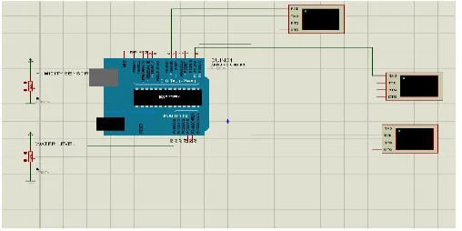
4. IMPLEMENTATION AND BLOCK DIAGRAM
Figure 4.1 – Block Diagram
The implementation for the necessary proposed system is mentioned with the help of the block diagram which explains the balloon connections consisting of the internal circuit connections as mentioned in the proposed system.
The Arduino UNO plays the important role of the motherboard chipset and it requires specific skills to implement the Arduino connections.
The zigbee is connected to another external computer to receive the output in displayed form about the count of the people as perceived in the camera and processed by the matlab software.
The APR Voice module is connected to the speaker to enhance the voice module performance. The voice module is complement device used here to record the input voice and transmit it as an alert invoice to people in dire need of it.
The sensors connection ,GPS, UART and the matlab connections are all made to the Arduino UNO. Thus, this also signifies the importance of the Arduino UNO.
5. SENSORS
Sensors are the devices whose purpose is to detect events or changes in its environment and send the information to the other electronics, frequently a computer processor. Sensor converts non electrical, physical or chemical quantity into an electrical signal. Sensor measures something which is called as measurand. American National Standards Institute states that a device which provides a usable output in response to a specified measurand is a sensor. A sensor acquires a physical quantity and converts it into a signal suitable for processing (e.g. optical, electrical, mechanical). Nowadays common sensors convert measurement of physical phenomena into an electrical signal. Active element of a sensor is called a transducer. The Sensors used here are the Water level sensor and Humidity sensor.
5.1 WATER LEVEL SENSOR
[image:3.612.362.540.219.363.2]Float Sensor is an electrical ON/OFF Switch, which operates automatically when liquid level goes up or down with respect to specified level. The Signal thus available from the Float Sensor can be utilized for control of a Motor Pump or an allied electrical element like Solenoid, Lamps, and Relays. Float Sensors contain hermetical sealed Reed Switch in the stem and a permanent Magnet in the Float. As the Float rises or falls with the level of liquid the Reed Switch is activated by Magnet.
Figure 5.1 – Water level sensor
Liquid Level Sensors operate on a direct, simple principle. In most models, a float encircling a stationary stem is
equipped with powerful, permanent magnets. As the float
rises or lowers with liquid level, the magnetic field generated from within the float actuates a hermetically sealed, magnetic reed switch mounted within the stem.
Side-mounted units use different actuation methods because of their horizontal attitude. The basic principle, however, is the same: as a direct result of rising or falling
liquid, a magnetic field is moved into the proximity of a reed switch, causing its actuation.
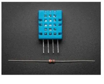
5.2 HUMIDITY SENSOR
[image:3.612.58.267.431.576.2]A humidity sensor is a device that measures the relative humidity of in a given area. A humidity sensor can be used in both indoors and outdoors. Humidity sensors are available in both analog and digital forms. This sensor module converts relative humidity to voltage and can be used in weather monitoring application.
Figure 5.2 – Humidity Sensor
An analog humidity sensor gauges the humidity of the air relatively using a capacitor-based system. The sensor is made out of a film usually made of either glass or ceramics. The insulator material which absorbs the water is made out of a polymer which takes in and releases water based on the relative humidity of the given area.
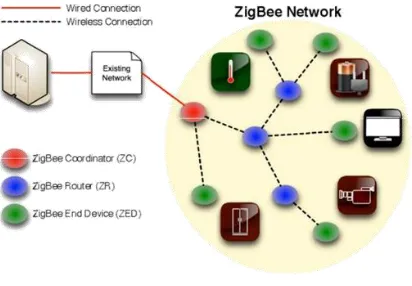
6. ZIGBEE
ZigBee is a mesh network specification for low-power wireless local area networks (WLANs) that cover a large area.
ZigBee was designed to provide high data throughput in applications where the duty cycle is low and low power consumption is an important consideration. (Many devices that use ZigBee are powered by battery.) Because ZigBee is often used in industrial automation and physical plant operation, it is often associated with machine-to-machine (M2M) communication and the Internet of Things (IOT).
6.1 ZIGBEE ARCHITECTURE
The main applications for 802.15.4 are aimed at control and monitoring applications where relatively low levels of data throughput are needed, and with the possibility of remote, battery powered sensors, low power consumption is a key requirement. Sensors, lighting controls, security and many more applications are all candidates for the new technology.
Figure 6.1.1 Zigbee Architecture
Figure 6.1.2 Zigbee Structure
The distances that can be achieved transmitting from one station to the next extend up to about 70 metres, although very much greater distances may be reached by relaying data from one node to the next in a network.
The main applications for 802.15.4 are aimed at control and monitoring applications where relatively low levels of data throughput are needed, and with the possibility of remote, battery powered sensors, low power consumption is a key requirement. Sensors, lighting controls, security and many more applications are all candidates for the new technology.
In order to communicate with a target device, a controller device first switches to the channel and assumes the PAN identifier of the destination ZigBee RF4CE PAN. It then uses the network address, allocated through the pairing
procedure, to identify itself on the ZigBee RF4CE PAN and thus communicate with the desired target device. Figure 1 illustrates an example ZigBee RF4CE topology which includes three target devices: a TV, a DVD and a CD player and each target device creates its own ZigBee RF4CE PAN. The TV, DVD and CD player also have dedicated Remote Control’s which are paired to each appropriate target device.
7. GPS
GPS Stands for GEOGRAPHICAL POSITIONING SYSTEM. It is a high gain GPS Receiver-RS232/USB made with ultra small High gain third generation POT (Patch Antenna on Top) GPS module. There is no prior configurations required, just apply power (9V) by DC adaptor or to RMC Connector from a battery or USB, your data (NMEA 0183) is ready at TX pin.
Figure 7.1 GPS
This is a stand alone GPS Module and requires no external components .It has a very compact and easy to integrate design with the ultimate tracking performances. It is also ideal for those who wish to plug-and-play GPS receiver module into their small form factor design. It can be directly connected to PC through USB (No separate Power Required) or RS232 (COM Port), MAX232 level converter IC required to connect microcontroller/Arduino.
8. APR9600
external digital circuitry such as micro-controllers and computers.
Figure 8.1 APR9600
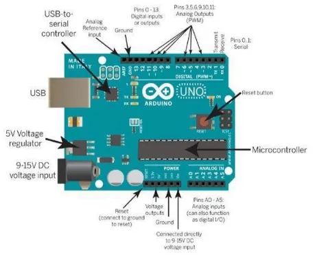
9. ARDUINO UNO
An Arduino is actually a microcontroller based kit which can be either used directly by purchasing from the vendor or can be made at home using the components, owing to its open source hardware feature. It is basically used in communications and in controlling or operating many devices. It was founded by Massimo Banzi and David Cuartielles in 2005.The Arduino Uno is a microcontroller board based on the ATmega328. It has 14 digital input/output pins (of which 6 can be used as PWM outputs), 6 analog inputs, a 16 MHz crystal oscillator, a USB connection, a power jack, an ICSP header, and a reset button. It contains everything needed to support the microcontroller; simply connect it to a computer with a USB cable or power it with an AC-to-DC adapter or battery to get started. The Uno differs from all preceding boards in that it does not use the FTDI USB-to-serial driver chip. Instead, it features the Atmega8U2 programmed as a USB-to-serial converter. "Uno" means one in Italian and is named to mark the upcoming release of Arduino 1.0. The Uno and version 1.0 will be the reference versions of Arduino, moving forward. The Uno is the latest in a series of USB Arduino boards, and the reference model for the Arduino platform; for a comparison with previous versions.
9.1 ARDUINO UNO ARCHITECTURE
[image:5.612.335.566.74.264.2]Arduino’s processor basically uses the Harvard architecture where the program code and program data have separate memory. It consists of two memories- Program memory and the data memory. The code is stored in the flash program memory, whereas the data is stored in the data memory. The Atmega328 has 32 KB of flash memory for storing code (of which 0.5 KB is used for the boot loader), 2 KB of SRAM and 1 KB of EEPROM and operates with a clock speed of 16MHz.
Figure 9.1.1 Arduino UNO Architecture
The most important advantage with Arduino is the programs can be directly loaded to the device without requiring any hardware programmer to burn the program. This is done because of the presence of the 0.5KB of Boot loader which allows the program to be burned into the circuit. All we have to do is to download the Arduino software and writing the code.
10. EMBEDDED C
Embedded C is the most popular embedded software language in the world. Most embedded software is written in Embedded C. It is a set of language extensions for the C Programming language by the C Standards committee to address commonality issues that exist between C extensions for different embedded systems.
Historically, embedded C programming requires nonstandard extensions to the C language in order to support exotic features such as fixed-point arithmetic, multiple distinct memory banks, and basic I/O operations. The C programming language is perhaps the most popular programming language for programming embedded systems.
Embedded C, even if it’s similar to C, and embedded languages in general requires a different kind of thought process to use. Embedded systems, like cameras or TV boxes, are simple computers that are designed to perform a single specific task. They are also designed to be efficient and cheap when performing their task.
reason why most embedded systems use Embedded C as a programming language is because Embedded C lies somewhere between being a high level language and a low level language. Embedded C, unlike low level assembly languages, is portable.
It can run on a wide variety of processors, regardless of their architecture. Unlike high level languages, Embedded C requires less resources to run and isn’t as complex. Some experts estimate that C is 20% more efficient than a modern language like C++. Another advantage of Embedded C is that it is comparatively easy to debug.
11. CONCLUSION
According to our project the information can be transmitted safely and securely to the People in rural areas and those who are struck by the destruction of the Natural Calamities. The project also helps to Provide emergency voice notes and Processes the information to the People in need.
[image:6.612.325.577.72.217.2]The Geo fencing mechanism and Information System provides s great overview of the situation ongoing in a place and the necessary adequate relief measures can be done. The Images are Processed by the Matlab software and location is accessed by the GPS.
Figure 11.1 Output through Arduino UNO
Figure 11.2 Output through the Sensors Count
Figure 11.3 Final Output received through the Zigbee
The Sensors of Humidity and Water Level are used to access the Wind stability and water level rising in a place and provides the adequate alert information to necessary people with the Use of ZigBee.
Thus the Sole Concept of our Proposed Project Emphasizes the idea of rescuing people and providing adequate information to the People Victimized by any natural calamity or where there is lack of electricity.
12. REFERENCES
1. S. Piao et al., “The impacts of climate change on water resources and agriculture in China,” Nature, vol. 467, no. 2, pp. 43–51, Sep. 2010.
2.Q. Miao, D. Yang, H. Yang, and Z. Li, “Establishing a rainfall threshold for flash flood warnings in China’s mountainous areas based on a distributed hydrological model,” J. Hydrol., vol. 541, pp. 371–386, Oct. 2016.
3. D. Sun, D. Zhang, and X. Cheng, “Framework of national non-structural measures for flash flood disaster prevention in China,” Water, vol. 4, no. 4, pp. 272–282, Mar. 2012.
4.T. L. Sweeney and T. F. Baumgardner, “Modernized flash flood guidance,” NWS Office Hydrol., Web Site Version, Updated, vol. 8, pp.16–99, 1992.
5. Pranoti Anandrao Salankar, Sheeja S. Suresh ―“Zigbee Based Underground Mines Parameter Monitoring System for Rescue and Protection” on IOSR Journal of VLSI and Signal Processing (IOSR-JVSP) Volume 4, Issue 4, Ver. I Jul-Aug. 2014.
[image:6.612.36.290.404.531.2]