Best Practices for Publishing, Retrieving, and
Using Spatial Data on the Web
Linda van den Brink
a,*, Payam Barnaghi
b, Jeremy Tandy
c, Ghislain Atemezing
d, Rob Atkinson
e,
Byron Cochrane
f, Yasmin Fathy
b, Raúl García Castro
g, Armin Haller
h, Andreas Harth
i,
Krzysztof Janowicz
j, ¸Sefki Kolozali
k, Bart van Leeuwen
l, Maxime Lefrançois
m, Josh Lieberman
n,
Andrea Perego
o,**, Danh Le-Phuoc
p, Bill Roberts
q, Kerry Taylor
hand Raphäel Troncy
raGeonovum, Barchman Wuytierslaan 10, Postbus 508, 3800 AM, Amersfoort, The Netherlands bInstitute for Communication Systems, University of Surrey, United Kingdom
cMetOffice, United Kingdom dMondeca, France
eMetalinkage, Australia
fLand Information New Zealand, New Zealand
gComputer Science School, Universidad Politécnica de Madrid, Spain
hCollege of Engineering & Computer Science, Australian National University, Australia iInstitute AIFB, Karlsruhe Institute of Technology, Germany
jGeography Department, University of California, Santa Barbara, CA, USA
kAnalytical & Environmental Sciences Department, King’s College London, United Kingdom lNetage, The Netherlands
mÉcole des Mines de Saint-Étienne, France
nCenter for Geographic Analysis, Harvard University, MA, USA oJoint Research Centre, European Commission, Italy
pOpen Distributed Systems, Technische Universität Berlin, Germany qSwirrl, United Kingdom
rData Science Department, Eurecom, France
Editor:Pascal Hitzler, Wright State University, USA
Solicited reviews:Xiaogang Ma, University of Idaho, USA; Christoph Schlieder, Universität Bamberg, Germany; two anonymous reviewers
Abstract.Data owners are creating an ever richer set of information resources online, and these are being used for more and more applications. Spatial data on the Web is becoming ubiquitous and voluminous with the rapid growth of location-based services, spatial technologies, dynamic location-based data and services published by different organizations. However, the heterogeneity and the peculiarities of spatial data, such as the use of different coordinate reference systems, make it difficult for data users, Web applications, and services to discover, interpret and use the information in the large and distributed system that is the Web. To make spatial data more effectively available, this paper summarizes the work of the joint W3C/OGC Working Group on Spatial Data on the Web that identifies 14 best practices for publishing spatial data on the Web. The paper extends that work by presenting the identified challenges and rationale for selection of the recommended best practices, framed by the set of principles that guided the selection. It describes best practices that are employed to enable publishing, discovery and retrieving (querying) spatial data on the Web, and identifies some areas where a best practice has not yet emerged.
Keywords: Geographic information systems, Spatial data, Web technologies, World Wide Web, W3C, Open Geospatial Consortium, OGC
*Corresponding author. E-mail: [email protected]. **The views expressed are purely those of the author and may not in any circumstances be regarded as stating an official position of the European Commission.
1. Introduction
Spatial data is important. Firstly, because it has be-come ubiquitous with the explosive growth in position-ing technologies attached to mobile vehicles, portable devices, and autonomous systems. Secondly, because it is fundamentally useful for countless convenient consumer services like transport planning, or for solv-ing the biggest global challenges like climate change adaptation [1]. Historically, sourcing, managing and using high-quality spatial data has largely been the preserve of military, government and scientific enter-prises. These groups have long recognized the im-portance and value that can be obtained by sharing their own specialized data with others to achieve cross-theme interoperability, increased usability and better spatial awareness, but they have struggled to achieve the cross-community uptake they would like. Spatial Data Infrastructures (SDIs) [2], which commonly em-ploy the mature representation and access standards of the Open Geospatial Consortium (OGC), are now well developed, but have become a part of the “deep Web” that is hidden for most Web search engines and human information-seekers. Even geospatial experts still do not know where to start looking for what they need or how to use it when they find it. The integration of spa-tial data from different sources offers possibilities to infer and gain new information; however, spatial data on the Web is published in various structures, formats and with different granularities. This makes publish-ing, discoverpublish-ing, retrievpublish-ing, and interpreting the spatial data on the Web a challenging task. By contrast, the linked data Web, as a platform of principles, tools, and standards championed by the World Wide Web Con-sortium (W3C) enables data discoverability and us-ability that is readily visible in, for example, search engine results for consumer shopping. The principles are based on proven aspects of the Web such as re-solvable identifiers, common representation formats, and rich interlinking of independently-published infor-mation, but adds explicit vocabulary management and tooling that targets the huge Web developer commu-nity. Can these principles be successfully applied to the world of complex spatial data to achieve the desired usability and utility?
There are, already, many good examples of projects and Web services that deliver to these goals, such as spatial data publication platforms in the Netherlands,1
1https://data.pdok.nl/datasets
Nanaimo City in Canada,2 or the UK Environmental Agency,3but also popular spatial data collections such
as Geonames.4However, spatial data custodians
strug-gle to find thebestway to publish their data in order to optimize the future impact as more data appears, more tools are developed, and the consumer commu-nity grows. Similarly, Web developers as data con-sumers and tool developers as foundation-stonemasons are demanding an expert consensus to guide their prod-uct development. The W3C and OGC standardization bodies jointly convened a large workshop in London in 2014 where these issues were extensively discussed over two days5. As a result of the interest,
enthusi-asm and challenges identified there, they proceeded to establish a joint working group to develop, amongst other things, a compendium of best practices for spa-tial data on the Web, published in September 2017 [3]. The working group completed its work in 2017, but was succeeded by an interest group6in which the work is continued.
This paper is a companion publication to the Spa-tial Data on the Web Best Practices Note that was en-dorsed by the working group, including the authors of this paper. It summarizes the work and describes the best practices themselves, but additionally presents the principles that guided the selection of these best practices, and the rationale underlying particular selec-tions. It also identifies some areas where a best practice seems to be needed but has not yet emerged.
1.1. Background: spatial data, the Web, and semantics
Any data (or metadata) that has a location compo-nent can be viewed as spatial data: its spatial nature means certain operations such as proximity and con-tainment functions have a meaning within the spatial domain. A location component is a reference to a place on Earth or within some other space (e.g., another planet, or a shopping mall) and can be many things: a physical object with a fixed location, such as a building or canal; an administrative unit, like a municipality or postal code area, or the trajectory of a moving object like a car. The power of spatial data is in the
oppor-2http://maps.nanaimo.ca/data/
3http://environment.data.gov.uk/bwq/profiles/ 4http://www.geonames.org
5Linking Geospatial Data (LGD’14). 5-6 March 2014, London. https://www.w3.org/2014/03/lgd/
Table 1
Standardized aspects of SDIs
Aspect Description Reference standards
Discoverability Annotate resources with metadata ISO 19115 [4, 5], ISO 19119 [6, 7] Accessibility Web services for discovering, viewing, downloading,
sharing geospatial raster data (coverages) etc.
OGC CSW [8], OGC WMS [9], OGC WFS [10], OGC WCS [11]
Portrayal Defining rules for displaying spatial data ISO 19117 [12], OGC SLD [13], OGC SE [14], OGC KML [15]
Information modeling Describing the contents of information resources, includ-ing geometry
ISO 19103 [16], ISO 19107 [17], ISO 19109 [18], ISO 19110 [19]
Data exchange Defining formats for exchanging the data OGC GML [20] Spatial reference systems Specifying the location on Earth of geographical
informa-tion
ISO 19111 [21, 22]
tunity to combine and integrate information based on location. While spatial data refers to any data that has a location component either on Earth or within some other space such as another planet (as defined earlier), geospatial data refers to any data that has a location in terms of geographic coordinates (e.g., GIS coordi-nates) within Earth. The focus of the Spatial Data on the Web Best Practices, and consequently of this pa-per, is on geospatial data. Although non-geospatial use cases were brought to the working group and were in-cluded in the Spatial Data on the Web Use Cases and Requirements (UCR) [23], there were no active par-ticipants in the working group who had expertise with spatial data other than geospatial. The focus was there-fore narrowed to geospatial data; requirements of non-geospatial data might be included in future work. This paper likewise deals almost exclusively with geospa-tial data. That said, many of the best practices are ap-plicable to wider spatial data concerns. In the remain-der of this paper, we simply refer to spatial data for brevity.
Spatial data can also have a temporal dimension. Temporal data varies over time. On the other hand, spatio-temporal data captures spatial data (i.e. current location) associated with the time the data is taken at that particular location [24]. However, in order to use spatial-temporal data, it has to be available and acces-sible. Common practice is to publish this data using an SDI. SDIs are based on a service-oriented archi-tecture (SOA), in which existing resources are docu-mented using dataset-level metadata, published in cat-alogs which are the most important discovery and ac-cess mechanism [25]. More detailed metadata describ-ing structure and content of datasets, as well as service requests and payloads, are far less commonly shared, and whilst standards suitable for some aspects of this
requirement are emerging, defining a common or best practice remains a challenge.
The Open Geospatial Consortium (OGC), founded in 1994, publishes technical standards necessary for SDIs to work in an interoperable way. These standards are based on the more abstract standards for geospatial information from the ISO Technical Committee 211 on Geographic information / Geomatics (ISO/TC 211). Different aspects of the SDI are standardized (see Ta-ble 1).
The OGC developed the first standards for spa-tial data Web services as of 1998 and has responded to early architectural trends in the Web (e.g., SOA). While SDIs and related standards were developing, so did the World Wide Web. Web standards like HTML, XML and RDF [26] were created in the nineties as well. While the Web started off as mostly documents with hyperlinks, over the years it evolved to much more sophisticated Web applications, including mass applications in which geospatial data was used, like Bing Maps, Google Maps, Google Earth and Open-StreetMap. More recently, XML has been replaced in many Web applications by more lightweight formats (e.g. JSON, and RDF).
As a generic model or framework, RDF can be used to publish geographic information. Its strengths include its structural flexibility, particularly suited for rich and varied forms for metadata required for different purposes. However, it has no specific fea-tures for encoding geometry, which is central to geo-graphic information. Several vocabularies and exten-sions have been proposed for this purpose, including a core RDF/OWL vocabulary for geographic informa-tion which is part of OGC’s GeoSPARQL [27].
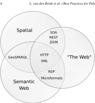
RDF
Microformats HTTP
XML SOA REST JSON
GeoSPARQL
Spatial
Semantic Web
"The Web"
Fig. 1. Commonalities between different communities of practice publishing data on the Web.
the last being characterized by large amounts of un-structured as well as un-structured data in various forms, and ad-hoc approaches to data publishing, driven by Web-centric skills and technologies, without explicit support for semantic or spatial aspects. Since the data is often published over HTTP in various formats and with different structure, XML formats are often used to integrate different data structures from different re-sources into the Web.
Spatial data can be published on the Web in the JSON format through a RESTful API or through a Spatial Data Infrastructure (SDI) based on a Service Oriented Architecture (SOA). RDF data is also widely used to describe and link resources on the Web. In the spatial data domain, for example, OGC’s GeoSPARQL is an RDF-based representation that is used to query spatial data.
1.2. Contributions
With the prevalence of sensor and actuator devices and the increase in location-based services, the use of spatial technologies is rapidly growing. The existing geospatial data, online maps combined with new forms of dynamic location-based data and services, create an opportunity for various new applications and services. However, to make spatial data more effectively avail-able across different domains, a set of common prac-tices are required.
The Spatial Data on the Web (SDW) Working Group7 has been committed to determining how
spa-tial data can best be published, discovered, queried and integrated with other data on the Web. This paper is the result of considerable effort on identifying these best practices for publishing and integrating spatial data on the Web. These Spatial Data on the Web Best Practices were published as a W3C Note [3] and as an OGC Best Practice.
This companion paper was written by members of the Spatial Data on the Web Working Group. It sum-marizes the key requirements for publishing, retriev-ing and accessretriev-ing spatial data on the Web to make it more interoperable, accessible, interpretable and un-derstandable by humans and machines, accompanied by know-how and best practices addressing those re-quirements. The main contribution of the paper is its additional background information about the rationale underlying the selection of the best practices. In addi-tion, the paper describes areas where best practices are still missing.
1.3. Paper organization
The rest of the paper is organized as follows: Sec-tion 2 explains a set of principles for setting out the scope of the problems that the best practices will ad-dress. Section 3 states the key requirements for pub-lishing and sharing spatial data on the Web, presents the related best practices as identified by the working group, and discusses how the best practices address the described requirements. Section 4 discusses several gaps that still exist in current practice. Finally, Sec-tion 5 draws conclusions and discusses the future di-rection.
In the remainder of this paper, we refer to the Spatial Data on the Web Best Practices as “SDWBP”.
2. Principles for describing best practices
As explained in the introduction, the aim of the work is to improve the discoverability, interoperability and accessibility of spatial data. The key principle follows from this: that through the adoption of the best prac-tices identified in the SDWBP, the discoverability and linkability of spatial information published on the Web is improved.
A second principle concerns the intended audience of the spatial data in question. The aim is to de-liver benefits to the broadest community of Web users possible—not to geospatial data experts only. The term ‘user’ signifies a data user: someone who uses data to build Web applications that provide information to end users—website visitors and app users—in some way. These data users are therefore among the intended au-dience of not only the spatial data, but also the Best Practice. The SDWBP provides value and guidance for application, website and tool builders to address the needs of the mass consumer market. Furthermore, the best practices should provide guidance for spatial data custodians. The best practices can offer a comprehen-sive set of guidelines for publishing spatial data on the Web.
A third principle is to have a broad focus. The first working draft of the best practices solicited several comments about a perceived “RDF bias”. While to de-velop spatial data following the 5-star Linked Data principles8was one of the goals at the start, the
solu-tions described in the best practices for discoverabil-ity and linkabildiscoverabil-ity should also be applicable to other spatial data on the Web. The best practices promote a linked data approach, but without asserting a strong as-sociation between linked data and RDF. Linked data requires only that the formats used to publish data support Web linking [28]. Furthermore, any ontolo-gies developed within the working group should not be tightly coupled with upper ontologies (“compatible with” rather than “dependent upon”); this avoids data publishers having to commit to a given world view, as specified within a particular upper ontology, in order for them to use the best practices and any ontologies related to them.
A fourth principle follows from the term ‘best prac-tice’ very directly: that its contents are taken from practice. The aim is not to reinvent or provide ‘best theories;’ in other words, the intention of the best prac-tice is not to create new solutions where good solutions already exist or to invent solutions where they do not yet exist. The contents of the best practice should be made up of the best existing practices around publish-ing spatial data on the Web that can be found. Conse-quently, the aim is for each of the best practices in the document to be linked to at least one publicly available example(s) of a non-toy dataset that demonstrates the best practice.
8http://5stardata.info
Lastly, the best practices should comply with the principles of the W3C Best Practices for Publishing Linked Data [29] and the W3C Data on the Web Best Practices [30]. Where they do not, this will be iden-tified and explained. The Data on the Web Best Prac-tices (referred to as DWBP henceforth) form a natural counterpart to the work on spatial data on the Web. The best practices are aligned with DWBP in the following ways: a) by using the same best practice template, and b) by referring to the DWBP instead of repeating it. While the focus of the best practices is on spatial data, they may include recommendations on matters that are not exclusively related to spatial data on the Web, but are considered by the Working Group to be essential considerations in some use cases for publishing and consuming spatial data on the Web, and not covered in enough detail in DWBP or other documents.
3. The key requirements and best practices for publishing spatial data on the Web
The following sections discuss the main topics cov-ered by SDWBP, and explains how they are addressed in the defined best practices. The topics are presented in a summarized fashion and are grouped thematically. Examples of datasets in which these best practices are implemented are not provided, since these are already present in the SDWBP. For the convenience of the reader, Table 2 outlines the best practices as they are stated in SDWBP, and indicates in which of the follow-ing sections they are discussed.
3.1. Geometries and spatial relationships
Table 2
The Spatial Data on the Web Best Practices [3]—and where they are discussed in the paper Best Practice 1 Use globally unique persistent
HTTP URIs for spatial things
§3.3 Best Practice 2 Make your spatial data indexable by search engines
§3.9
Best Practice 3 Link resources together to create the Web of data
§3.3 Best Practice 4 Use spatial data encodings that match your target audience
§3.1, §3.6 Best Practice 5 Provide geometries on the Web in a
usable way
§3.1, §3.10
Best Practice 6 Provide geometries at the right level of accuracy, precision, and size
§3.1, §3.5, §3.8 Best Practice 7 Choose coordinate reference
sys-tems to suit your user’s applications §3.2, §3.5, §3.7
Best Practice 8 State how coordinate values are en-coded
§3.2
Best Practice 9 Describe relative positioning §3.10 Best Practice 10 Use appropriate relation types to link spatial things
§3.1
Best Practice 11 Provide information on the chang-ing nature of spatial thchang-ings
§3.3, §3.6, §3.7
Best Practice 12 Expose spatial data through ‘conve-nience APIs’
§3.3
Best Practice 13 Include spatial metadata in dataset metadata
§3.4 Best Practice 14 Describe the positional accuracy of spatial data
§3.5
One of the key best practices (namely, Best Prac-tice 5) is therefore about providing geometries on the Web in a usable way. A single best way of publishing geometries was not identified; what is ‘best’ is in this case primarily related to the specific use case and tool support, which determine the geometry format to be used, the coordinate reference system (CRS) (more de-tails are included in Section 3.2), as well as the level of accuracy, precision, size and dimensionality of geom-etry data. Note that these aspects are interrelated: for instance, the dimensionality of a geometry constrains the CRSs that can be used, as well as the geometry en-codings.
Best Practice 5 identifies three scenarios in which geometries can be used: specific geospatial applica-tions, linked data applicaapplica-tions, and Web consumption. The practice also offers guidelines for choosing the right vocabularies from several available ones for de-scribing geometry in each scenario. Currently, there are two geometry formats widely used in the geospa-tial and Web communities, respectively, GML [20] and GeoJSON [32]. GML provides the ability to express any type of geometry, in any CRS, and up to 3 dimen-sions (from points to solids) but is typically serialized in XML. GeoJSON supports only one coordinate ref-erence system (CRS84—i.e., WGS 84 longitude / lati-tude), and geometries up to 2 dimensions (points, lines, surfaces) but it is serialized in JSON, which is often easier for browser-based Web applications to process. In the Linked Data community, several specific vocab-ularies for RDF-based representations of geometries are available, such as GeoSPARQL [27], W3C Basic
Geo [33], GeoRSS [34], or the ISA Core Location vo-cabulary [35]. Appendix A of SDWBP offers a com-parison of the most common spatial ontologies.
Instead of catering for a single scenario, spatial data publishers should offer multiple geometric representa-tions when possible, balancing the benefit of ease of use against the cost of the additional storage or addi-tional processing if converting on-the-fly. This can be implemented using HTTP content-negotiation; how-ever, this only works for media-type, character set, en-coding and language. Consequently, it is not possible to select one representation that conforms to a given “profile” (e.g., data model, complexity level, CRS) from several that all share the same media-type.
Note that publishing geometries on the Web need not always be called for. Although spatial relationships can often be derived mathematically based on geome-try, this can be computationally expensive. Topologi-cal relationships such as these can be asserted, thereby removing the need to do geometry-based calculations. Exposing such entity-level links to Web applications, user-agents and Web crawlers allows the relationships between resources to be found without the data user needing to download the entire dataset for local analy-sis.
3.2. Coordinate reference systems and projections
Fig. 2. Elipsoid and spherical coordinates. (“Cre-ative Commons Attribution 3.0 Australia” license from ICSM.gov.au—Intergovernmental Committee on Surveying and Mapping).
such as latitude, longitude and (optionally) elevation, or in a projected Cartesian coordinate space. The latter involves the flattening of a sphere in exchange for mak-ing it vastly easier to accurately measure area and dis-tance. Regardless of the Coordinate Reference System (CRS) chosen, a distortion of the data will occur ei-ther in relative angles (positions), sizes (areas), or dis-tances. Best Practice 7 identifies the World Geodetic System 1984 (WGS 84—EPSG:4326), which provides a good approximation at all locations on the Earth, as the most commonly used CRS for spatial data on the Web, but also explains when EPSG:4326 is not recom-mended, especially in use cases that require a higher level of accuracy than WGS 84 can offer.
In the Spatial Data on the Web Working Group, there was a lot of discussion on this topic. There are a lot of concerns with WGS 84 in the geospatial com-munity. However, WGS 84 is dominant on the Web; it is used by most online mapping providers (e.g. Google, Bing, OpenStreetMap) and popular formats such as GeoJSON. Some explanation is required in or-der to unor-derstand the concerns of the geospatial com-munity. All spatial coordinate frameworks begin with a mathematical model of the object being mapped. For the Earth, (which is not a true spheroid) an ellip-soid model, most fitting to the area being mapped, is commonly used (Figure 2). A Geodetic Datum is then placed on top of the reference ellipsoid to allow numer-ical expression of position. This may include a Vertnumer-ical Datum, usually an approximation of sea level, to
ref-Fig. 3. Projected CRS. (Public domain image fromScientific Amer-icancirca 1923).
erence height and depth. WGS 84 (EPSG:6326) is an example of a Geodetic Datum based on the WGS 84 (EPSG:7030) Ellipsoid. It uses latitude and longitude coordinates (anchored to the equator and poles) to in-dicate position.
Geodetic CRSs are useful for collecting informa-tion within a common frame. The measurements they use are good for plotting directions but difficult to use when calculating area or distance. Latitude and longi-tude are angular measurements that do not convert eas-ily to distance because their size in true units of mea-sure (e.g., meters) varies according to location on the sphere. They become smaller as you near the poles.
Fig. 4. The Web site http://thetruesize.com/ is a good tool for com-paring sizes of countries at different latitude and shows the distortion which results from flattening a sphere.
To summarize, WGS 84 is by far the most common CRS for spatial data on the Web. However, other CRSs exist for good reasons. Best Practice 7 therefore rec-ommends that spatial data be published in CRSs to suit the potential user’s applications. Spatial data on the Web should be published at least in WGS 84, and addi-tionally in other CRSs if there are use cases demanding this.
The ability to unambiguously identify the CRS used is fundamental for the correct interpretation of spatial data. For instance, part of the information defined in a CRS concerns the order in which the geographic coor-dinates (i.e., latitude, longitude, etc.) are encoded, the units of measurement used for these coordinates, as well as thedatumused. Mistaking the coordinate order (i.e., theaxis order) is a very common error that results in plotting the data in a completely different location. Best Practice 8 specifically addresses this issue, by re-quiring that this information is made explicit, either by specifying the CRS used—use of EPSG codes, where they exist, is recommended9—, or by using data for-mats / vocabularies where this information is implicit (e.g., GeoJSON [36] and the W3C Basic Geo
vocabu-9EPSG is a register of CRSs maintained by the IOPG, an oil industry organization. The ESPG register is available online at: http://www.epsg-registry.org/.
lary [33] support only one CRS—respectively, CRS84 and WGS 84).
3.3. Spatial identifiers
Spatial things should be uniquely identified with persistent Uniform Resource Identifiers (URIs) in or-der for those using spatial data on the Web (Best Prac-tice 1) to be able to definitively combine and refer-ence these resources (Best Practice 3): they become part of the Web’s information space; contributing to the Web of Data. URIs are a single global identifica-tion system used on the World Wide Web, similar to telephone numbers in a public switched telephone net-work. HTTP(S) URIs are a key technology to support Linked Data by offering a generic mechanism to iden-tify entities (‘Things’) in the world and to allow refer-ring to such entities by others. Anyone can assign iden-tifiers to entities (‘Things’) in a namespace they own, i.e. a domain name within the Internet—e.g., hospitals, schools, roads, equipment, etc. ‘Spatial things’, such as the catchment area of a river, the boundaries of a building, a city or a continent, are examples of such ‘Things’ on the Web that need to be identified so that it is possible to refer to or make statements about this particular spatial thing.
Spatial things described or mentioned in a dataset on the Web should be identified using a globally unique URI so that a given spatial thing can be unambiguously identified in statements that refer to it. Good identifiers for data on the Web should be dereferenceable / re-solvable, which makes it a good idea to use HTTP—or HTTPS—URIs as identifiers. Data publishers need to assign their subject spatial things HTTP URIs from an Internet domain name where they have authority over how the Web server responds. Typically, this means minting new HTTP URIs. Important aspects of this include authority, persistence, and the difference be-tween information resources and the thing they give information about. The use of a particular Internet do-main may reinforce the authority of the information served. HTTP can only serve information resources such as Web pages or JSON documents. Best Prac-tice 1 contains no requirement to distinguish between the spatial thing and the page/document unless an ap-plication requires this.
DBpe-dia 10 and GeoNames11 or public government data, such as a national registers of addresses. Mapping and cadastral authorities maintain datasets that pro-vide geospatial reference data. Re-using well-known identifiers is a good practice because it makes it easy to recognize that data from different sources are related. An example of a spatial thing URI is http://sws.geonames.org/2172517/ which identifies the spatial thing Canberra, while when resolved in a browser returns information such as the name of the spatial thing, the centroid location, geographical boundaries, etc.
When exposing spatial data through standard SDIs (e.g., WFS services [10]), a certain user group is catered for, i.e., users with the expertise and tooling to use these services based on standards from the geospa-tial domain. To allow more users to benefit from the data it is important to expose the link to the Web repre-sentation of the features on the Web. Best Practice 12 identifies two approaches for doing this while keep-ing the SDI in place. One is to add an attribute to all spatial things, namedrdf_seealso, which con-tains the URI of the Web representation of the spatial thing visible on the map. The Web representation is created by mapping the data in the SDI dynamically to crawlable resources on the Web using the R2RML standard [37] and Linked Data Publication tools. This approach leverages existing SDIs while enriching them with dereferenceable linked data representations of the spatial things. Exposing the data about a spatial thing as linked data makes sure that the attributes themselves will be URIs and thus unambiguous. The overhead of the extra attribute on existing SDIs is negligible and traditional clients will not be hindered by the extra at-tribute, but more advanced usage allows unlocking of a wealth of connections behind the traditional spatial data.
The other approach is to create a RESTful API as a wrapper, proxy or a shim layer around WFS services. It is worth mentioning that different spatial data ser-vices are often making their data accessible through REST API services. Content from the WFS service can be provided in this way as linked data, JSON or another Web-friendly format. There are examples of this approach of creating a convenience API that works dynamically on top of WFS such as the experimen-talldproxy.12 This is an attractive option for quickly
10http://dbpedia.org 11http://geonames.org
12https://hub.docker.com/r/iide/ldproxy/
exposing spatial data from existing WFS services on the Web. The approach is to create an intermediate layer by introducing a proxy on top of the WFS (data service) and CSW (metadata service) [8] so the con-tained resources are made available. The proxy maps the data and metadata to schema.org [38] according to a provided mapping scheme; assigns URIs to all re-sources based on a pattern; makes each resource avail-able in HTML, XML, JSON-LD [39], GML [20], Geo-JSON [36], and RDF/XML (metadata only); and gen-erates links to data in other datasets using SPARQL queries [40].
3.4. Discovery of spatial information
Cataloging of spatial information has always been difficult, whether the data is digital or not. A roadmap for Wellington NZ may be filed under NZ, Welling-ton, Transportation, tourism or a large number of other categories. Spatial data therefore has a greater require-ment for metadata. Best Practice 13 recommends the inclusion of spatial metadata in dataset metadata. As a minimum, the spatial extent should be specified: the area of the world that the dataset describes. This in-formation is necessary to enable spatial queries within catalog services such as those provided by SDIs and often suffices for initial discovery. However, further levels of description are needed for a user to be able to evaluate the suitability of a dataset for their in-tended application. This includes at least spatial cover-age (continuity, resolution, properties), and represen-tation (for example vector or grid coverage) as well as the coordinate reference system used.
In SDIs, the accepted standard for describing meta-data is ISO 19115 [4, 5] or profiles thereof. To provide information about the spatial attributes of the dataset on the Web, DCAT [41] is recommended. An applica-tion profile of DCAT for geospatial data, GeoDCAT-AP [42], can be applied to more fully express spatial metadata. In addition, several spatial ontologies, al-ready mentioned in Section 3.1, allow the description of spatial datasets.
3.5. Scale and quality
Therefore, having quality information about spatial data on the Web significantly facilitates two main tasks to the consumer of such data. One of them is the se-lection of data, allowing to focus on data that satisfy the needs of a concrete use case. For example, spatial data accuracy is important when using them in the ap-plication of self-driving cars; guiding an autonomous vehicle to a precise parking spot near a facility that has a time-bounded service and then booking the charg-ing spot requires accurate location data. Another is the reuse of data, i.e., understanding the behavior of data in order to adapt its processing (e.g., by considering data currentness, refresh rate or availability). A funda-mental concept of spatial data is the scale of the rep-resentation of the spatial thing. This is important be-cause combining data designed to be used at differing scales often produces misleading results. A scale is of-ten represented as a ratio or shorof-tened to the denomi-nator value of a ratio. A 1:1,000 (or 1,000) scale map is referred to as larger than a 1:1,000,000 (or 1,000,000) scale map. Conversely, a million scale map is said to be a smaller scale than a thousand scale map. Data col-lected at a small scale is most often more generalized than data collected at a larger scale. Concepts related to scale are resolution (the smallest difference between adjacent positions that can be recorded), accuracy (the amount of uncertainty—how well a coordinate desig-nates a position on the actual Earth’s surface) and pre-cision (the reproducibility of a measurement to a cer-tain number of decimal places in coordinate values).
When publishing spatial data on the Web, they should be supplemented with information about the precision and accuracy of such data. Such quality in-formation should at least be available for humans. Best Practice 14 is concerned with positional accuracy and how spatial data should be accompanied with informa-tion about its accuracy. Best Practice 7 asserts a link between CRS and data quality, because the accuracy of spatial data depends for a large part on the CRS used, as was explained in a previous section. In order to sup-port automatic machine-interpretation of quality infor-mation, such information should be published follow-ing the same principles as any other data published on the Web. The CRS of geometries on the Web should al-ways be made known. For describing other quality as-pects, the W3C Data Quality Vocabulary (DQV) [43], which allows specifying data quality information (such as precision and accuracy), could be used.
Even if the recommendations in Best Practice 14 fo-cus on precision and accuracy, evidently the same
ad-vice can be followed for other relevant spatial quality information.
3.6. Thematic layering and spatial semantics
Spatial data is typically collected in layers. Al-though this sounds very map-oriented, these layers can be thought of as collections of instances of a class within a spatial and temporal frame. In other words, layers are usually organized semantically. Although SDWBP does not address layers directly, it does ad-dress spatial semantics. DWBP recommends the use of vocabularies to communicate the semantics, i.e., the meaning of data, and preferably standardized vocab-ularies. There are several vocabularies about spatial things available, such as the W3C Basic Geo vocab-ulary [33], GeoRSS [34], GeoSPARQL [27], the ISA Core Location Vocabulary [35] or schema.org [38]; overviews on their uses are provided in the litera-ture [44–46]. Best Practice 4 identifies the main vocab-ularies in which spatial things can be described when the aim is data integration; however, it does not rec-ommend one of them as the best. Currently there is no common practice in the sense of the same spatial vo-cabulary being used by most spatial data publishers. This depends on many factors; furthermore, describ-ing spatial data multiple times usdescrib-ing different vocabu-laries maximizes the potential for interoperability and lets the consumers choose which is the most useful. Appendix A of SDWBP offers guidance for selecting vocabularies by providing a table comparing the most commonly used ones.
The most important semantic statement to be made when publishing spatial data—or any data—is to spec-ify the type of a resource. The W3C Basic Geo vo-cabulary has a class SpatialThing which has a very broad definition. This can be applicable (as a generic concept) to most of the common use-cases. Thematic semantics and general descriptions of spa-tial things and their properties should be provided as linked data. They should have URIs that return human-and machine-readable definitions when resolved.
3.7. Temporal dimension
whether the data suits their needs. For instance, tec-tonic movements over time can distort the coordinate values of spatial things.
This is included in Best Practice 7 on coordinate ref-erence systems as valuable knowledge when dealing with spatial data for precision applications. Further-more, it is recommended in Best Practice 13 to include metadata statements about the (most recent) publica-tion date, the frequency of update and the time period for which the dataset is relevant (i.e., temporal extent). Apart from the need for enhancing spatial data with their temporal context, the temporal dimension also af-fects the very nature of spatial things, since both spa-tial things and their attributes can change over time; this is covered in Best Practice 11. When dealing with changes to a spatial thing, its lifecycle should be taken into account; in particular, how much change is accept-able before a spatial thing can no longer be considered as the same resource (and requires defining a new re-source with a new identifier). Creating a new rere-source will depend on whether domain experts think the fun-damental nature of the spatial thing has changed, tak-ing into account its lifecycle (e.g., a historic buildtak-ing replaced by another that has been built on top of it). In this case, the temporal dimension of spatial data can be expressed by providing a series of immutable snap-shots that describe the spatial thing at various points in its lifecycle, each snapshot having a persistent URI.
In those cases when the spatial thing itself does not change over time but its attributes do, the description of the spatial thing should be updated to reflect these changes, and each change published as a snapshot. In contrast, when a spatial thing has a small number of attributes that are frequently updated (e.g., the GPS-position of a runner or the water level from a stream gauge), the time-series of data values within such at-tributes of the spatial thing should be represented. This is relevant in relation to recent advances in embedding smart sensors and actuators in physical objects and ma-chines such as vehicles, buildings, and home appli-ances, which has led to the publishing of large volumes of data that are spatio-temporal [47].
3.8. Size of spatial datasets
Spatial data tends to be very large. This can pose dif-ficulties when sharing or consuming spatial data over the Web—particularly in low bandwidth or high la-tency situations. Accurate (polygon) geometries tend to contain a high number of coordinates. Especially when querying collections of spatial things with
ge-ometries over the Web, this results in very large re-sponse payloads wasting bandwidth and causing slow response times, while for some very common use cases, like simply displaying some things on a Web map, high accuracy is not required. The primary basis for simplification is scale. For example, when search-ing for a Starbucks on a city scale, an accuracy of 3 meters is acceptable, but when providing street-level directions to a shop for a self-driving car it is not.
For those use cases that do not require high ac-curacy, common ways of dealing with reducing the size of spatial data include degrading precision by reducing the number of decimals, and simplifying geometries using a simplification algorithm such as Ramer-Douglas-Peucker [48, 49] or Visvalingam-Whyatt [50]. These methods result in lower accuracy and precision.
Big spatial data is often not vector data, i.e., a repre-sentation of spatial things using points, lines, and poly-gons [16], but coverage data, i.e., gridded data: a data structure that maps points in space and time to prop-erty values [51]. For example, an aerial photograph can be thought of as a coverage that maps positions on the ground to colors. A river gauge maps points in time to flow values. A weather forecast maps points in space and time to values of temperature, wind speed, humid-ity and so forth. For coverage data, other methods are required to manage size.
DWBP recommends to provide 1) bulk download and 2) subsets of data. Providing bulk-download or streaming access to data is useful in any case and is relatively inexpensive to support as it relies on standard capabilities of Web servers for datasets that may be published as downloadable files stored on a server. Subsets, i.e., extracts or “tiles”, can be pro-vided by having identifiers for conveniently sized sub-sets of large datasub-sets that Web applications can work with [52]. Actually, breaking up a large coverage into pre-defined lumps that you can access via HTTP GET requests is a very simple API. A second way of supporting extracts, more appropriate for frequently changing datasets, is by supplying filtering options that return appropriately sized subsets of the specific dataset.
3.9. Crawlability
from HTML pages in order to find additional sources to crawl, and indexers, i.e., different types of indexes, typically using the occurrence of text on a Web page, that are maintained by search engines.
A major issue with crawlers identified in the early 2000’s by Bergman [53] was the inaccessibility of the so-called “deep Web”: information that was hidden to traditional crawlers as it is only accessible through ser-vices (e.g., forms) that require user input. Several so-lutions have since been introduced to access and index information on the “deep Web” [54, 55]. Spatial Data services (e.g. OGC Web services and/or other APIs) typically make information available only after user in-put has been provided, leading to a similar problem, i.e., a Deep Spatial Web. Further, these services are built to be accessed and searched by domain-specific applications rather than general Web services and/or search engine crawlers. For example, in the OGC ar-chitecture, catalog services are intended to be used for searching spatial assets by using specific client tools, and are not optimized for indexing and discovery by general purpose search engines. However, a typical Web user does not know that these catalogs exist and is accustomed to using general purpose search engines for finding information on the Web. Therefore, mak-ing sure that spatial data is indexable by Web search engines is an important approach for making spatial data discoverable by users directly. The addition of structured data to Web services that are otherwise not accessible to search engines increases the visibility of a service or dataset in major search engines [56]. Schema.org [38], a single schema across a wide range of topics that includes people, places, events, products, offers, etc., and widely supported by Bing, Google, Yahoo! and Yandex, is the predominant way of mark-ing up content and services on the Web with struc-tured data to improve the presentation of the result in a search engine [56]. To verify if schema.org markup on a Web page is recognized by Web agents, Google’s Structured Data testing tool13can be used.
Experimen-tal work such as Geonovum’s Spatial Data on the Web Testbed14 describes ways to make spatial data index-able by publishing an HTML Web page for the spa-tial dataset and each spaspa-tial thing that it contains; by using structured data, schema.org and links, as well as publishing XML sitemaps containing links to all data resources for spatial data services. Another example is
13https://search.google.com/structured-data/testing-tool 14https://github.com/geo4web-testbed/general
the Dutch geoportal PDOK.nl which extensively pub-lishes dataset metadata, for example, the national roads dataset,15resulting in better accessibility through
com-mon search engines. Several examples of spatial things published in this way are provided in Best Practice 2.
Currently, spatial information, even when published in accordance with these guidelines, is not widely ex-ploited by search engines. However, by increasing the volume of spatial information presented to search en-gines, and the consistency with which it is provided, it is expected that search engines will begin offering spatial search functions. Evidence is already seen of this in the form of contextual search, such as prioritiza-tion of search results from nearby entities. In addiprioritiza-tion, search engines are beginning to offer more structured, custom searches that return only results that include certain schema.org types such asDataset,Place orCity.
3.10. Other aspects of spatial data
Spatial things may have 0 to 3 dimensions (points, lines, areas, 3D), and it may be difficult to combine similar things if the dimensions in which they are rep-resented differ. Although SDWBP does not address this at length, Best Practice 5 does recommend de-scribing the number of dimensions in metadata and notes that one of the selection criteria for choosing a geometry format on the Web is the dimensionality of the data.
In common language, and for spatial things inher-ently related to mobile things, it may be convenient to describe positions of spatial thingsrelativeto other spatial things. Just as for other spatial things, we would like such descriptions to be both human- and machine-interpretable. We advise, in Best Practice 9, that po-sitions or geometries of the target reference things should be retrievable via link relations, in accord with general principles for linkability in Section 2. The geo-centric use case (i.e., position relative to the Earth) is generally addressed throughout SDWBP and does not require an explicit link relation to the Earth. As the ac-tive contributors to SDWBP were primarily interested in the geocentric case, SDWBP does not explore rela-tive positioning in depth. We find that practices in this area vary widely in the details of implementation and so we are able to offer only broad advice and examples. Spatial relationships as described for Best Practice 10
(Section 3.1) may be useful, but we find no evidence for suitable common vocabularies for many needs. For some spatial data, thesymbologyassociated with the data is of high importance because it communicates meaning. However, as rendering maps is explicitly out of scope, symbology is not addressed in SDWBP.
4. Gaps in current practice
The best practices described in brief in Section 3, and in full in the SDWBP document, are compiled based on evidence of real-world application. This is in line with the fourth principle described in Section 2 of this paper. However, there are several issues that in-hibit the use or interoperability of spatial data on the Web, for which no evidence of real-world applied so-lutions was found. These issues are denoted “gaps in current practice” and described as such in this sec-tion. An issue is considered a gap when no evidence of real-world applied solutions in production environ-ments was found. The term ‘production environment’ signifies a case where spatial data has been delivered on the Web with the intention of being used by end users and with a quality level expected from such data. In contrast, a “testing environment” is published with the intent of being tested so that bugs can be discov-ered and fixed and an experimental publication of spa-tial data on the Web is published with the intent of, for example, exploring possibilities, learning about the technology, or other goals besides publishing with the intent of serious use. In the case of gaps, there might be emerging practice, i.e., a solution that has been the-orized for a certain issue and has possibly been ex-perimented on in testing/beta settings, but not in pro-duction environments. Gaps and emerging practices in the area of publishing spatial data on the Web are dis-cussed in this section.
4.1. Representing geometry on the Web
Location information can be an important ‘hook’ for finding information and for integrating different datasets. There are different ways of describing the lo-cation of spatial things: referencing the name of a well-known named place, describing a location in relation to another location, or providing the location’s coor-dinates as a geometry. The latter allows the integra-tion of data based on locaintegra-tion using spatial reasoning, even when explicit links between things are not avail-able, as well as, of course, showing spatial things on
a map. Although there are ways to represent geometry in Web data, there are still some gaps in current prac-tice related to selecting a serialization format, select-ing an embedded, file-based or Linked Data approach, and making geometries available in different CRSs.
Third, there is a question of how to make geometries available in different CRSs. Section 3.2 explains the existence of many CRSs and why spatial data should be published in CRSs that are most common to poten-tial users. It follows that, on the one hand, the CRS should be specified for geometries published on the Web and, on the other hand, users should be able to find out which CRSs are available and to get geome-tries using the CRS of their choice.
Sometimes the CRS used is clear from the represen-tation. In other cases the CRS needs to be specified ei-ther on the dataset level or the instance level. How this is done differs for each serialization. For example, in GeoSPARQL this is added as a prefix of the WKT lit-eral while in GML an attributesrsNamecan be spec-ified on geometry elements. In an OGC WFS [10] re-quest, users can specify the CRS they wish to use by specifying thesrsNameparameter. In GeoSPARQL the getSRID function returns the spatial reference system of a geometry, thus making it possible to re-quest a specific CRS at a (Geo)SPARQL endpoint. However, these options require the user to be proficient in either geospatial Web services or Linked Data.
A best practice for returning geometries in a spe-cific requested CRS has not yet emerged. Many op-tions can be found in current practice, including cre-ating CRS-specific geometry properties (for exam-ple, the Dutch Land Registry does this), and sup-porting an option for requesting a specific CRS in a convenience API; but one best practice cannot yet be identified. Another option worth exploring might be the use of content negotiation, i.e., nego-tiate CRS as part of the content format for the ge-ometry, as has also been proposed for encoding for-mat. For example, this could be done with an extra media type parameter (e.g., application/ttl; geomLiteral="WKT"; crs="CRS84") or by adding specific request and response headers for ne-gotiating CRS to the HTTP protocol. A contribution to address this issue might be provided by the W3C Dataset Exchange Working Group (DXWG), which is due to deliver a specification on profile-based con-tent negotiation.16 However, providing different CRS might be too complicated to handle in the HTTP pro-tocol. For example, multidimensional datasets will in general use multiple CRSs (e.g., horizontal, vertical and temporal, maybe more), and conversion between
16For a description of this deliverable, see the DXWG Charter: https://www.w3.org/2017/dxwg/charter.
CRSs will, in general, introduce errors, so data in one CRS are not exactly the same as data in another CRS. Furthermore, CRS is just one of a number of parame-ters that may characterize a particular geometric repre-sentation of a spatial thing, including the type of geom-etry, its relationship to the Thing, method of interpo-lation, scale or resolution. However, offering a choice between all these parameters of data objects such as geometries might be an overloading of HTTP content negotiation protocols. It might, therefore, be more ap-propriate to handle this in the application layer.
4.2. A spatial data vocabulary
Although a large amount of geospatial data has been published on the Web, so far there are few authori-tative datasets containing geometrical descriptions of spatial things available in Web-friendly formats. Their number is growing (e.g., at the time of writing there are three authoritative spatial datasets publicly avail-able as linked data in the Netherlands containing to-pographic17, cadastral18, and address19 data), but cur-rently there is no common practice in the sense of the same spatial vocabulary—or the same combination of spatial vocabularies—being used by most spatial data publishers. The consequence is the lack of a baseline during the mapping process for application develop-ers trying to consume specific incoming data. Identi-fying administrative units, points of interest or postal addresses with URIs could be beneficial not only for georeferencing other datasets, but also for interlinking datasets georeferenced by the direct and indirect loca-tion informaloca-tion.
Direct georeferencing of data implies representing coordinates or geometries and associating them to a CRS. This requires vocabularies for geometries and able to specify which CRS is used. Further, indirect georeferencing of data implies associating them to other data on named places. Preferably, these data on named places should be also georeferenced by coordi-nates in order to serve as the basis for data linking be-tween indirectly and directly georeferenced datasets. Moreover, vocabularies developed for representing specific sets of geospatial data on the Web should reuse as much as possible existing ones. This is the case for the vocabularies developed by IGN France for
tries,20 topographic entities,21 and CRS.22 These vo-cabularies contain alignments with existing vocabular-ies, e.g., the classgeom:Geometryis a subclass of bothsf:Geometry (OGC Simple Features vocab-ulary) which is a subclass of the Geometry class of the GeoSPARQL vocabulary; andngeo:Geometry (Neogeo vocabulary). Furthermore, the topographic entity class from the IGN France vocabulary is de-clared equivalent to the Feature class from the Geonames vocabulary.
In W3C Basic Geo [33], it is assumed that the CRS used is WGS 84. However, publishers might have data in a different, local CRS. Thus, there is a need for a more generic class for, for example, a point geometry with the benefit of choosing the CRS of the underlying data [60]. Existing vocabularies, as GeoSPARQL [27] and ISA Core Location [35], support this feature, but there are currently no best practices for their consistent use, thus hindering interoperability.
Vocabularies like the one by IGN France are cre-ated because, currently, the existing vocabularies do not cover all requirements and no guidance is avail-able on their consistent and complementary use. SD-WBP partially addresses the latter issue, by providing examples on how to model spatial information with widely used vocabularies. However, solving the exist-ing gaps would require the definition of new terms in existing or new vocabularies, which was not in scope with the work of the Spatial Data on the Web Work-ing Group. A possible way forward is an update for GeoSPARQL. This would provide an agreed spatial ontology, i.e., a bridge or common ground between ge-ographical and non-gege-ographical spatial data and be-tween W3C and OGC standards, conformant to the ISO 19107 [17] abstract model and based on exist-ing vocabularies such as GeoSPARQL [27], the W3C Basic Geo Vocabulary [33], GeoRSS [34], NeoGeo or the ISA Core Location vocabulary [35]. The updated GeoSPARQL vocabulary would define basic semantics for the concept of a reference system for spatial co-ordinates, a basic datatype, or basic datatypes for ge-ometry, how geometry and real world objects are re-lated and how different versions of geometries for a single real world object can be distinguished. For ex-ample, it makes sense to publish different geometric representations of a spatial object that can be used for different purposes. The same object could be modeled
20http://data.ign.fr/def/geometrie/20160628.en.htm 21http://data.ign.fr/def/topo/20140416.en.htm 22http://data.ign.fr/def/ignf/20160628.en.htm
as a point, a 2D or a 3D polygon. The polygons could have different versions with different resolutions (gen-eralization levels). And all those different geometries could be published with different coordinate reference systems. Thus, the vocabulary would provide a foun-dation for harmonization of the many different geome-try encodings that exist today. An alternative approach is to establish best practices for the consistent use of the most popular spatial vocabularies. An example are the guidelines for the RDF representation of INSPIRE data developed in the framework of the EU ISA Pro-gramme [61] by following the SDWBP recommenda-tions. In such a scenario, the definition of new classes and properties would be limited to cover the gaps in the existing vocabularies.
4.3. Spatial aspects for metadata
Even if all spatial data should become discoverable directly through search engines, data portals would still remain important hubs for data discovery—for ex-ample, because the metadata records registered there can be made crawlable. But, in addition, different data portals can harvest each others’ information provided there is consistency in the types and meaning of in-cluded information, even if structures and technolo-gies vary. Discovery of spatial data is improved in the Netherlands, for example, because the national general data portal23harvests the spatial data portal and thus all
spatial datasets are registered in the general data portal as well.
In the eGovernment sector, DCAT [41] is a standard for dataset metadata publication, and harvesting this metadata is implemented by eGovernment data portals. Because DCAT is lacking in possibilities for describ-ing some specific characteristics of spatial datasets, an application profile for spatial data, GeoDCAT-AP [42, 62], has been developed in the framework of the ISA Programme of the European Union,24with the primary purpose of enabling the sharing of spatial metadata across domains and catalog platforms. To achieve this, GeoDCAT-AP defines RDF bindings covering the core profile of ISO 19115:2003 [4] and the INSPIRE [63] metadata schema, enabling the harmonized RDF rep-resentation of existing spatial metadata. The focus was on the most used metadata elements, whereas addi-tional mappings—as well as the alignment with the lat-est version of ISO 19115 [5]—could be defined in
ture versions of the specification, based on users’ and implementation feedback.
One of the outcomes of the development of GeoDCAT-AP was the identification of gaps in exist-ing RDF vocabularies for representexist-ing some spatial information [64]—such as coordinate reference sys-tems and spatial resolution (see also Section 4.2 on this topic). But it also highlighted a key issue for spa-tial data, in that the use of global and persistent iden-tifiers is far from being a common practice. Apart from making it difficult to implement a Linked Data-based approach, this situation has negative effects on the geospatial infrastructure itself. E.g., it makes it im-possible to unambiguously identify a spatial thing or a dataset over time, and it prevents an effective im-plementation of incremental metadata harvesting in a federated infrastructure (such as the INSPIRE one).
Notably, recent activities are contributing to fill at least part of these gaps. For instance, DQV [43] pro-vides a solution for modeling precision and accu-racy, as mentioned in Section 3.5. Moreover, the use cases collected by the W3C Dataset Exchange Work-ing Group [65] cover also geospatial requirements, which might be addressed by the work of this group in the revision to DCAT [41]. However, the consistent use of global and persistent identifiers in the geospatial do-main is an issue that, far from being merely technical, affects the data management workflow, and therefore needs to be addressed also at the organizational level.
4.4. Describing dataset structure and service behaviors
Datasets may be arbitrarily large and complex, and may be exposed via services to expose useful re-sources, rather than a “download” scenario. Data gath-ered using automated sensors, in particular, may be im-possible to download in its entirety due to its dynamic nature and potential volumes. It is, therefore, neces-sary in these cases to be able to adequately describe the structure of such data and how services interact to expose subsets of it—even individual records in a Linked Data context. Such datasets are common in the information processing world, and commonly orga-nized in “hypercubes”—where “data dimensions” are used to locate values holding results. A standard based on this dimensional model of data is the RDF Data Cube vocabulary (QB) [66]. It has been used to pub-lish sensor data; for example to pubpub-lish a homogenized daily temperature dataset for Australia over the last 100 years [67]. However, QB is lacking in possibilities
for describing spatio-temporal aspects of data, which are very important for observations. One of the work items in the Spatial Data on the Web Working Group was, therefore, an extension to the existing QB vocab-ulary to support specification of key metadata required to interpret spatio-temporal data, called QB4ST [68].
QB4ST is an extension to QB to provide mecha-nisms for defining spatio-temporal aspects of dimen-sion and measure descriptions. It is intended to enable the development of semantic descriptions of specific spatio-temporal data elements by appropriate commu-nities of interest, rather than to enumerate a static list of such definitions. It provides a minimal ontology of spatio-temporal properties and defines abstract classes for data cube components (i.e., dimensions and mea-sures) that use these, to allow classification and discov-ery of specialized component definitions using general terms. QB4ST is designed to support the publication of consistently described re-usable and comparable defi-nitions of spatial and temporal data elements by appro-priate communities of practice. One obvious such case is the use of GPS coordinates described as decimal lat-itude and longlat-itude measures. Another example is the intended publication of a register of Discrete Global Grid Systems (DGGS) by the OGC DGGS Working Group. QB4ST is intended to support publication of descriptions of such data using a common set of at-tributes that can be attached to a property description (extending the available QB mechanisms for attributes of observations). The Spatial Data on the Web Work-ing Group has demonstrated the use of QB and QB4ST to serve satellite imagery through DGGS and a virtu-alized triple store [52].
4.5. Versioning of spatial data
be-tween people and devices, observe near real-time phe-nomena and actuate devices or robots. The Tactile In-ternet is focused on speeding up this interaction pro-cess and reducing the latency in communication sys-tems. Such high-speed communication will bring new challenges for intelligent systems. There is a big gap in the lightweight and semantically rich representa-tion of versioning and temporal aspects of spatial data content. There have been a few attempts to represent changing and moving spatial objects, such as OGC’s TimeSeriesML [72] and Moving Features [73]. How-ever, although these ontologies provide a reasonably good semantic coverage, there is still a need for the development of lightweight and semantically rich rep-resentations to conduct enhanced (near) real-time op-erations. Having heavy semantic expressivity in on-tologies can cause a burden on reasoning engines and can slow down the processing time for machines. For instance, it is important to identify and represent the direction and coverage area of a surveillance camera or the orientations and positions of objects or people in the observed environment. In the future, a broken car will be fixed by a robot, or surgeries will be carried out by multiple robots using Tactile Internet [74]. It can also be envisioned that people, who have difficulty in walking, will not need to use a walking stick but merely a strap of an exoskeleton. These must be con-trolled by wireless systems to monitor the coverage, direction, and identify the objects and people around them including their shapes.
To conduct such activities, a better representation is needed for not only spatial information but also tem-poral and geometrical aspects of objects. Observed ob-jects can change their size during the actuation pro-cess. For instance, a group of surgical robots will need to know about the shape of an organ and the changes regarding its size, geometrical shape, and orientation during surgery and exchange this information among themselves and with doctors to conduct an operation with high precision and low latency. A self-driving wheelchair or a self-driving car will be able to com-municate with other sensor objects regarding the sur-rounding environment and direction to avoid obstacles. This will prevent possible accidents and harm caused by machines, such as not falling down stairs or run-ning into objects with high speed or force. In all these scenarios, lightweight representation and exchange of temporal-spatial knowledge are essential to understand and react fast enough to prevent disasters or to control the movement of devices. Having the means to repre-sent the semantics of activities and phenomena at such
high granularity and lightweight format will play a piv-otal role in the development of future Internet tech-nologies. Moreover, it will allow machines to instantly exchange information including spatial and geometri-cal knowledge and carry out their tasks with high pre-cision. The Spatial Data on the Web Interest Group25,
the successor of the Working Group, will address the topic of representing moving objects on the Web.
5. Conclusions
Spatial data has become ubiquitous with the ex-plosive growth in positioning technologies attached to mobile vehicles, portable devices, and autonomous systems. It has proven to be fundamentally useful for countless things, ranging from everyday tasks like finding the best route to a location to solving the biggest global challenges like climate change adapta-tion. However, spatial data dissemination is heteroge-neous and although the Web is commonly used as a publication medium, the discovery, retrieval, and inter-pretation of spatial data on the Web is still problematic. SDWBP describes how Web principles can be ap-plied to the world of complex spatial data to solve this problem. Good practices can be observed in current practice and have been collected into the Best Prac-tices based on a set of principles and an examination of practice. In some cases, a best practice has not yet emerged. There are still questions related to represent-ing geometry on the Web, with regard to recommend-able serialization forms and formats, and the use of coordinate reference systems. A Web-friendly way of publishing spatial metadata has not yet been described in full, especially with regards to the relevant subset of spatial metadata standards. A standardized ontol-ogy for spatial things that covers all the main require-ments for publishing spatial linked data is not yet avail-able, and best practices on the consistent use of the existing spatial vocabularies are yet to be established. Finally, there are new approaches emerging such as QB4ST [68], an extension to the RDF Data Cube to provide mechanisms for defining spatio-temporal as-pects of dimension and measure descriptions.
Notwithstanding these gaps and emerging solutions, a useful set of actionable best practices for publishing spatial data on the Web has been described. Following these guidelines will enable data users, Web