314
TOPOGRAPHIC SURVEY CARRIED OUT FOR THE REHABILITATION
AND MODERNIZATION OF THE ROAD FROM THE
AGRO-BALNEOTURISTIC LOCATION BALA, MEHEDINŢI COUNTY
CĂLINA A., CĂLINA JENICA*,MILUȚ M., CROITORU A., IONICĂ C.E., VANGU M.
*Author to whom all correspondence should be addressed: e-mail: [email protected]
Keywords: topographic survey, GPS, total station, coordinates, topographic plan
ABSTRACT
The purpose of the work is to produce the technical documentation necessary to prepare the design and execution of all the construction works, which will be executed for the modernization and rehabilitation of the road taken in the study. In this sense, the work team carried out a preliminary topographic study based on which an overview of the situation existing on the field was formed, which also offered the possibility of the designer choosing the most suitable design and execution solutions. Topo-geodesic works were performed using the combined GPS-total station method, using modern equipment that ensured high accuracy and high economic efficiency. The final documentation obtained is of the highest technical and scientific level, respecting all the norms and requirements of precision and quality imposed by the regulations and laws in force, such engineering works, these being verified and approved by OCPI-Mehedinti.
INTRODUCTION
At the request of the beneficiary, the specialist surveyor made topo-cadastral surveys necessary for the modernization of the road in Bala, Mehedinți County. The modernization of the road from the locality of Bala was absolutely necessary, because it was in a very advanced state of degradation and no longer technically corresponded, both for the conduct of the current traffic and for the taking over of the tourist circulation that took place towards a balneoclimatic resort (Franzutti, R., Vîntu, C.R., et al, 2019). The locality being a tourist village that also has a resort must have modern and easy traffic conditions (Dobra, C. and Csosz, C., 2019), which will lead to the sustained development of agrotourism and spa tourism in the area (Iancu, T., et al, 2017), and the traffic on the road route must be carried out under maximum
safety conditions. In order to carry out the work, it was necessary to carry out planimetric and levelling survey on the route of the entire road from the territory of Bala in Mehedinți county, based on which the plan of location and delimitation with quotas will be drawn up, necessary for the design, mapping and execution of the rehabilitation and modernization works (Calina, A. and Calina, J., 2019). All topographic measurements were made in the Stereographic Projection System 1970 and in the Black Sea Dimension System 1975, with the help of two South S82-V GNSS receivers and with the TC 805 total station with an accuracy of ± 5cc, under all conditions of precision and legislation, imposed on such engineering works.
WORKING METHOD
From the technical point of view, the survey was done largely with the help of GPS technology, the differential
315
takes data from the fixed receiver. The central area of the town was raised with the help of the total station due to the height of the buildings and the low GPS signal. Four high-precision points were determined with the help of GPS, following which this network will be thickened by a supported planimetric route. With this, the dimensions of the points were determined by trigonometric leveling. Solving the supported route allowed the construction of a lifting support network on the basis of which the polar coordinates method could be used to raised all the detail and characteristic points of the route followed, using the combined surveiyng technology of the GPS-total station type.
RESULTS AND DISCUSSIONS
The building that is the object of this Technical Reception is "Modernization of the road from Bala, Mehedinți county", the road having the surface of 6784 m2,
and the work as a whole having the surface of 23485 m2. Equipment used:
two South S82-V receivers, channel number: 220, signals: GPS, GLONASS, Accuracy: static, horizontal accuracy = 3mm 1ppm (RMS), vertical accuracy = 5mm 1ppm (RMS), RTK mode , Horizontal Positioning Accuracy = 1cm, 1ppm (RMS), Vertical Positioning Accuracy = 2cm, 1ppm (RMS), Leica TC
805 Total Station, Accuracy: ± 5cc (Călina, J., et al, 2018). The field operations due to the conformation of the field were carried out as follows: first a point located at a higher level was identified, namely point 1, which was marked and then the receiver was fixed, which will remain fixed for the duration of the measurements. This point is chosen so as to ensure the signal for the entire duration of the measurements and on the entire surface to be raised. The lifting of the area was carried out with the mobile receiver, which takes data from the fixed receiver, by the method of differential measurements (DGPS), being determined the points from 2 to 1126. The minimum number of satellites used by the device during the measurements was of 11, of the type GPS and GLONASS, resulting in a very high accuracy in determining the coordinates of the points. Due to the low signal and the height of the buildings in the central area, four high precision points were determined, with the help of the mobile receiver, after which, with the help of the total station, a planimetric supported at the ends was made, to determine the skeleton of the surveiyng network, after which the points of detail required for the documentation was determined by the polar coordinates method (table1).
Table 1
Data from the field book
Point no. Absolute rectangular coordinates Z Codes
X Y
1 379915,868 328432,455 288,525
2 380104,848 328319,550 265,072 grd
3 380103,892 328318,311 265,168 dr
... ... ... ... ...
1126 378925,174 328531,423 240,656 grd
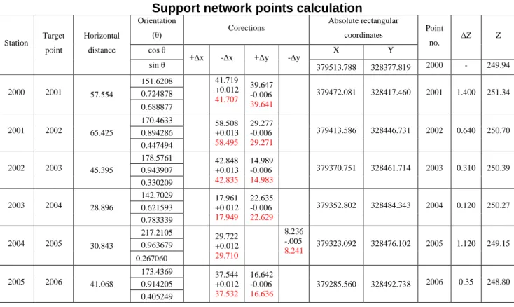
When designing the support network, a very precise method was used, namely the planimetric traverse supported at the point of departure and arrival, a method that allows us to verify the data both on the ground and at the
316
topographic description, including the number of the point , coordinates and data on the type of materialization. The traverse works were carried out in this way, initially the device was installed in point 2001, where it was fitted and centered on the topographic point. From this point was targeted point 2000, direction whose orientation I calculated it from coordinates, then went visa to point 2002, being measured orientation angle Θ1 and horizontal distance Do 2001-2002, as
well as vertical angle Z1. The same was done at each point, measuring the orientation angles Θ 2, Θ 3, Θ 4, Θ5, the
zenith angles Z2, Z3, Z4, Z5 and the
distances between the points of traverse (figure 1).
All the data from the field were entered in table 2, based on them calculating the relative and absolute coordinates of the support points. The obtained results were verified very accurately using known procedures, and only after their rigorous verification could they be used in other elevations on the respective surface or in other works of cadastral character.
Figure 1. Outline of the support network
Table 2
Support network points calculation
Station Target
point
Horizontal
distance
Orientation
(θ) Corections
Absolute rectangular
coordinates Point
no. ΔZ Z
cos θ
+Δx -Δx +Δy -Δy X Y
sin θ 379513.788 328377.819 2000 - 249.94
2000 2001 57.554
151.6208 41.719
+0.012 41.707
39.647 -0.006 39.641
379472.081 328417.460 2001 1.400 251.34
0.724878 0.688877
2001 2002 65.425
170.4633 58.508
+0.013 58.495
29.277 -0.006 29.271
379413.586 328446.731 2002 0.640 250.70
0.894286 0.447494
2002 2003 45.395
178.5761 42.848
+0.013 42.835
14.989 -0.006 14.983
379370.751 328461.714 2003 0.310 250.39
0.943907 0.330209
2003 2004 28.896
142.7029 17.961
+0.012 17.949
22.635 -0.006 22.629
379352.802 328484.343 2004 0.120 250.27
0.621593 0.783339
2004 2005 30.843
217.2105 29.722
+0.012 29.710
8.236 -.005
8.241 379323.092 328476.102 2005 1.120 249.15
0.963679
0.267060
2005 2006 41.068
173.4369 37.544
+0.012 37.532
16.642 -0.006 16.636
379285.560 328492.738 2006 0.35 248.80
317 Calculation of non-closing errors: The error on Δx; e Δx = -0.074 m; c Δx = +0.074 m; c Δx = +0.0124 Δx and +0.0132 Δx
The error on ΔY; e ΔY= 0.035 m; c ΔY= -0.035 m; c ΔY= -0.0065 ; ΔY and -0,0051 ΔY.
Total error = + =0,081859m 2
2
y x
t e e
e
Tolerance calculation:
) 5000 003
, 0
(
+
= D D
T
m
T ) 0.103
5000 681 . 269 181 . 269 003 , 0
( + =
=
The lifting of the details was carried out by polar coordinates method, defining the position of a point according to the angle and the polar distance (Sui D., 2014). This is the most widely used method by
topographic specialists, applicable in any field conditions. Measurement of the angles was done in both positions of the rear window, thus obtaining a greater accuracy of measurement.
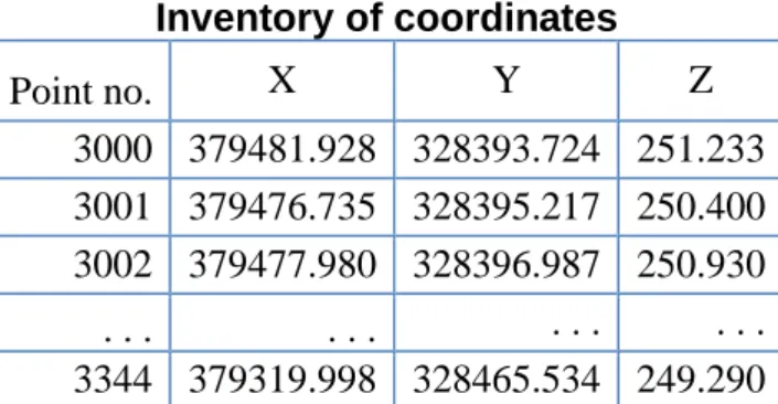
The detail points, 319 in number, were determined from several stations, these being: 2001, 2002, 2003, 2004 and 2005. The coordinates were obtained using the Toposys program, (Braun, J., Kremen, T. and Pruska , J., 2018), following the import of the measurements and then by the export, the coordinate inventory was obtained according to table 3, in the facsimile, due to the large number of data that should have been put into the paper.
Table 3
Inventory of coordinates
Point no. X Y Z
3000 379481.928 328393.724 251.233 3001 379476.735 328395.217 250.400
3002 379477.980 328396.987 250.930
. . . . . . . . . . . .
3344 379319.998 328465.534 249.290
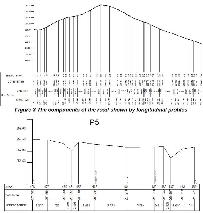
Being a work of repair and modernization of a road, it was absolutely necessary to produce longitudinal profiles at all the characteristic points as well as at the points where the beneficiary requested this (Alipour, H. et al. 2019). The longitudinal profiles were performed on the 1: 2000 scales for the lengths (figure 3) and 1: 500 for the heights, at the points marked on the road axis, to represent the relief as accurately as possible. Based on the profiles prepared (figure 3) it was found that the road has slopes between 0 -16%. In adverse weather, it becomes quite difficult to practice. The road has areas with long alignments and areas with succession of curves and short alignments. The route projected in the plan is totally superimposed on the route
of the existing road. For a good knowledge of the constructive elements of the roadway and an accurate representation of the situation on the ground, it was necessary to prepare the cross-sections (Raza, H., et al, 2017), at 1: 100 stairs for lengths and 1:50 for heights, being placed perpendicular to the road axis. These were executed at varying distances, due to the terrain configuration.
318
Figure 3 The components of the road shown by longitudinal profiles
Figure 4 The components of the road shown by cross profiles
Carlson SurvCE software was used to facilitate the calculation operations and to reduce working time (Calinovici, I., 2009), based on which measurements were made directly in the national projection system Stereo 1970, SurvCE, having implemented and the program TransDat 4.01, giving the user identical results with it, in real time. This program runs on the Odin model field notebook, providing all
the data related to the measurement, from the device field notebook, the txt data and files, are transferred to the computer where the location and delimitation plan is drawn up. Based on this, the design and execution of all the repair and modernization works were carried out.
CONCLUSIONS
The surveiyng methods used were very well adapted to the existing situation on the ground, which facilitated the
319
modern like GPS and Total Stations, the last generation, which allowed to obtain very precise data on the ground and the substantial increase of the efficiency and the efficiency of the topographic works carried out for this purpose. The data processing programs used were efficient and perfectly adapted to the topographic works carried out, which allowed the calculation of the absolute coordinates of the points and their compensation, with the highest precision required by such engineering works, while also facilitating the preparation of the site plan and precise and rapid delimitation, at the stairs requested by the beneficiary, in the different phases of the project execution project. From the ones presented above it can be seen that the working team has been permanently concerned with obtaining valuable and high precision cadastral data, which will lead to obtaining an execution project realized to the highest quality standard and which corresponds to scientific point of view at a very high level, an aspect that will lead to the accomplishment of the modernization works in the best conditions and of a faultless quality.
BIBLIOGRAPHY
1. Alipour, H., Jalalian, A., Honarjoo, N., Tommanian, N. and Sarmadian, F., 2019, Spatial and Temporal Distribution of Dust‐Bound Trace Metal Elements Around Kuhdasht Watershed Area in Iran.
CLEAN–Soil, Air, Water, p.1900318. 2. Braun, J., Kremen, T. and Pruska, J., 2018, June. Micronetwork for Shift Determinations of the New Type Point Stabilization. In 2018 Baltic Geodetic Congress (BGC Geomatics) (pp. 265-269). IEEE.
3. Călina, J., Călina, A., Bădescu, G.,
Vangu, G.M. and Ionică, C.E., 2018.
Research on the use of aerial scanning for completing a GIS database. AgroLife Scientific Journal, 7(1), pp.25-32.
4. Calina, A. and Calina, J., 2019.
Research regardig the agriproductive properties of the typical reddish
preluvosol between Jiu and Olt rivers and its evolution from 1997-2017 in farms and agritouristic households. Romanian agricultural research, 36, pp.251-261. 5. Calinovici I., and Călina Jenica, 2008, Topography, Ed., Mirton, Timișoara.
6. Calinovici, I., 2009, Researches
Concerning the Topography of an Area of Ground with the Purpose of its Agroecological Reconstruction. In Proceedings. 43rd Croatian and 3rd International Symposium on Agriculture. Opatija. Croatia (Vol. 125, p. 128).
7. Dobra, C. and Csosz, C., 2019. Rural tourism in Romania. Characteristics and measures for future development. Lucrări
Științifice Management Agricol, 20(3), p.122.
8. Franzutti, R., Vîntu, C.R., Smedescu, D., Ungureanu, D., Tudor, V.C. and Fîntîneru, G., 2019. The national rural development program-a chance for agrotourism development in the Suceava county. Scientific Papers: Management, Economic Engineering in Agriculture & Rural Development, 19(2).
9. Iancu, T., Brad, I., Adamov, T.,
Stanciu, S., Pîrvulescu, L. and
Gabriela, P., 2017. Characterization of rural tourism activity in the mountain area.
Lucrări Științifice, Universitatea de Științe Agricole Și Medicină Veterinară a Banatului, Timisoara, Seria I, Management Agricol, 19(1), pp.145-148. 10. Raza, H., Park, S.I., Lee, S.S., Tanoli, W.A. and Seo, J., 2017. 3D Earthwork BIM Design Process for a Road Project. Journal of KIBIM, 7(2), pp.8-15.
11. Şmuleac, A., Popescu, C., Bărliba,
L., Ciolac, V., & Herbei, M., 2017. Using the GNSS technology tothicken geodesic network in Secaș, Timiș county, Romania. Research Journal of Agricultural Science, 49(3).
12. Sui D., 2014. Opportunities and Impediments for Open GIS. Transactions
in GIS, 18 (1), p. 1-24, doi:10.1111/tgis.12075.