A Provisional Correlation of Stratigraphy, Radiometric Dates, and Archaeological Components at the GerstleRiver Site, Central Alaska1
Ben A. Potter2
ABSTRACT
Recent excavations at the Gerstle River Site Lower Locus revealed four archaeological components in deeply stratified (>4 m) contexts. This paper integrates and synthesizes stratigraphy, radiocarbon dates, and archaeological components from previous investigations of both the Upper and Lower Loci in order to reconcile various interpretations, and to integrate the 1999 and 2000 materials and radiocarbon dates in an appropriate spatial and temporal context. Six components are present at this site, dating from ~11,200 to 4,200 cal BP3. Three components exhibit microcore and blade technology indicative of the Denali complex.
Keywords: stratigraphy, early Holocene, Denali complex
INTRODUCTION
Background
The Gerstle River site (49XMH-246) is a multi-component site situated between the Tanana and Gerstle Rivers in Interior Alaska. The precise number and stratigraphic position of these components have not been synthesized to date. Other excavated sites in the Tanana basin with early Holocene components such as Healy Lake Village and Chugwater have interpretive difficulties resulting from conflicting dates and excavation in arbitrary levels at the former site (Cook 1969, 1996, Erlandson et al. 1991) and shallow deposits, cryoturbation, root penetration at the latter site (Maitland 1986, Lively 1996, 1988). The stratigraphy at both Broken Mammoth and Swan Point sites have been analyzed in detail by Dilley (1998).
Gerstle River offers a rare opportunity to examine site structure and artifact patterning in stratified contexts relatively free from cryoturbation and other post-depositional disturbances. However, the majority of the data from excavation at Gerstle River remains to be collated and synthesized. Several ambiguities regarding radiocarbon dating and correlation of archaeological components occur in published and unpublished records (see Kimura et al. 1989, Holmes 1998, Kotani n.d.). The purpose of this paper is to address these ambiguities by synthesizing the extant stratigraphic and archaeological data in the form of artifact distribution and radiocarbon assays and to briefly describe the components found at the upper and lower loci. Correlation of the stratigraphy and archaeology at both loci will contribute to the delineation of a number of archaeological components, and provide the dated context for critically needed well-defined assemblage data. Components with good stratigraphic and spatial controls are essential for assemblage definition and the subsequent construction of cultural chronologies. The record for Late Pleistocene – Early Holocene in the Alaskan interior is limited by a small number of excavated sites, and even fewer with stratigraphic controls. By providing the stratigraphic contexts for the components present at Gerstle River, this paper adds to the meager record of interior Alaskan dated sites. Technological analysis of the components is beyond the scope of this paper, and detailed assessments of these components within the context of traditional cultural chronologies of Interior Alaska (Cook and McKennan 1970; Dixon 1985; Bacon 1987; West 1996) are not discussed.
This synthesis is based on the four published "gray literature" reports of the site (Holmes and Dilliplane 1976, Rabich and Reger 1978, Kimura et al. 1989, and Holmes 1998), original unpublished field notes, stratigraphic profiles, and spatial artifact data from the 1985 excavation by Kotani and the 1996 testing by Holmes, and Potter's 1999 and 2000 excavations (Holmes and Potter 2000). No site report or field notes (other than stratigraphic profiles) exist for the 1983 and 1985 excavations. I am currently analyzing the
1
Anthropological Papers of the University of Alaska, New Series 2(1):73-93. 2
University of Alaska Fairbanks, Department of Anthropology, and Northern Land Use Research, Inc., Fairbanks.
3
1996, 1999-2001 artifact collections at the University of Alaska Fairbanks Department of Anthropology, but some of the 1976, 1977, 1983, and 1985 data have only recently been recovered from Japan. Given these limitations, the synthesis presented here documents as fully as possible the nature of the stratigraphic record at this site. The artifact collections and profiles from the 2001 excavation seasons are not included in this analysis and the cultural component summaries.
Physical Environment
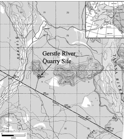
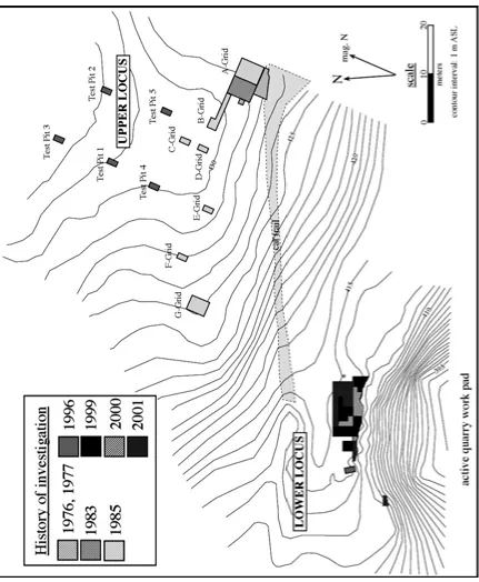
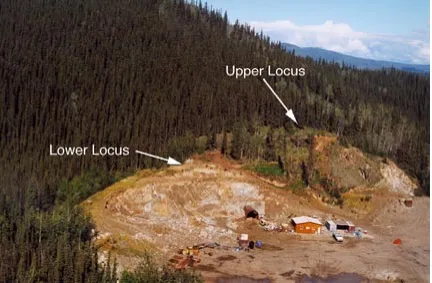
The site is located on a southern knob of a bedrock hill rising 137 meters above the surrounding outwash plain one mile east of the Gerstle River, a large braided river in the middle Tanana basin (Figure 1). Surrounding vegetation is typical bottomland spruce forest, though the southern exposures contain some xeric taxa. It is difficult to reconstruct the original contours of the southern part of the hill due to past quarrying activity by the Alaska Department of Transportation and Public Facilities (Figures 2 and 3). Much of the lower hillside has been destroyed, and a caterpillar trail was made leading to the discovery of the site in 1976 through eroding artifacts at the upper area (Holmes and Dilliplane 1976). Current vegetation at the Upper Locus is characterized by a closed white spruce (Picea glauca) forest with a sphagnum moss understory; the Lower Locus is disturbed, with vegetation consisting primarily of aspen (Populus tremuloides) and grass.
History of Research
The Gerstle River Quarry Site has been investigated several times since its discovery in 1976 by Charles Holmes (Holmes and Dilliplane 1976). After initial testing in 1976, in 1977, Holmes excavated 12 m2 finding two components in stratified context (Rabich and Reger 1978). In 1983 and 1985, Japanese researchers under the general direction of Yoshinobu Kotani excavated 71 m2 from the Upper Locus, recovering thousands of artifacts, faunal remains, and identifying at least two probable features. The only report on these investigations is a Japanese-language report published by the Japanese Museum of Ethnology in 1989 (Kimura et al. 1989). This paper was recently translated by a University of Alaska Fairbanks Anthropology student, Hiroko Ikuta, thus allowing for the full synthesis presented here. However, the paper only details lithic artifact distributions for part of the 1985 excavation (A-grid, see below), with minimal information on artifacts recovered in 1983, and no data on the faunal remains. No features were mentioned in the paper, though the original plan-views of several excavation units illustrate concentrations of bone, charcoal, and artifacts. It is possible that hearths were excavated in the 1985 excavation of A- and G-grids. Several scatters of large cobbles labeled “debris” and shaded areas labeled “carbon” were noted in the Japanese field plan maps. Faunal remains were also noted, but no information regarding taxa or element was provided in the report. In 1996, Holmes conducted further testing at the Upper Locus and excavated the first test pit at the Lower Locus recovering fauna and artifacts from multiple strata. In 1999, 2000, and 2001, I excavated 36 m2, 16 m2, and 32 m2 respectively at the Lower Locus, documenting three components, two of which predate the lowest component found in the Upper Locus (Potter and Holmes 2000; Potter 1999, 2000a, 2000b, 2001a, 2001b).
With a total of 182 m2 excavated, 22 radiocarbon dates, over 7,000 lithic artifacts, and hundreds of faunal remains in 6 components spanning most of the Holocene, this site offers an important, complex dataset for examining various issues in Alaskan archaeology, such as the technology and systemic use of microblades, exploitation of bison and wapiti, site structure and activity area delineation, and basic issues of cultural chronology (see Mason et al. 2001; Hamilton and Goebel 1999; Yesner 1996). This is possible with the data accurately synthesized, varying interpretation reconciled, and the artifacts and faunal remains placed in their appropriate spatial and temporal contexts.
STRATIGRAPHY AND DEPOSITS
massive compact eolian silt with a three Bw horizons classed as entisols and a lower cryept paleosol capped with a modern incipient cryochrept (subarctic brown forest soil) (Dilley 1998:230-233; 278). His interpretations have been largely been substantiated by further work (Potter 2000a, 2001b). However, the tephra present below the modern soil tentatively identified as the northern lobe of the White River Ash (Dilley 1998: 233) was later shown through microprobe analysis by James Begét to display an unknown composition (Begét, pers. comm. 2000). The stratigraphic unit descriptions generally follow Dilley (1998:232-233) and Holmes (1998:7), with data from loss-on-ignition and particulate size analyses of the Lower Locus sediments conducted by the author of this paper (Table 1).
Post-depositional disturbance to sediment are present in various forms at the Upper and Lower Locus. Krotovinas are noted within the lower loess (Y5) at both areas, although no krotovinas were observed in or near the 1999-2000 excavation units. A number of microfaults (slip faults) of limited dimension were observed in both loci, extending from Y2 to R4 and Y2 to Y3 on the A-grid north wall; R4-R5 on the C-grid east wall, Surface 2 to R3 on the G-C-grid east wall; R2-R4 on the Test Pit 1 east wall; R3 to R4 on the Test Pit 3 east wall; and R1 to Y2 on the Block C north wall. The faults are minor with a slippage of 3 to 11 cm, and in no case did they obfuscate strata delineation. Machine scraping related to quarrying has turbated or removed some of the upper strata at the Lower Locus. Prior to the 1999 excavation, the Lower Locus was bladed by bulldozer down to the undisturbed sediments. The total depth of overburden varied from less than a meter to 1.5 m. Several swallow nests were exposed in the course of the 1999 and 2000 excavations, and all tunnels were mapped, but none affected the distributions of artifacts or strata delineation.
There is little evidence of cryoturbation in the form of solifluction lobes or ice wedge pseudomorphs, and strata are horizontal for the most part with gently undulating contacts. There is evidence of a minor change in topography at the Lower Locus between 11,600 and 9,200 cal BP, possibly relating to changes in local wind patterns (see Figure 7, N48E39-41). There is little evidence of post-depositional turbation, and the vast majority of artifacts were horizontal, including large bones and boulder spall scrapers. The three-dimensional plotting of artifacts from all components at the Lower Locus and plots of artifacts at the Upper Locus indicate unimodal distributions with little vertical variation. Thus, the effects of cryoturbation and other disturbances are deemed minimal at both loci.
STRATIGRAPHIC CORRELATION OF PROFILES AND ARCHAEOLOGICAL COMPONENTS
Stratigraphic Data
Each investigation generated stratigraphic data in the form of profile drawings, allowing for comparisons among the various excavations. The 1976 report provided a single 50 cm wide profile drawn from the eastern edge of the bulldozed area (Holmes and Dilliplane 1976:VII-10). A total of 60 linear meters of stratigraphic profiles have been obtained from the Upper Locus: 16 m for the 1977 excavation, none for the 1983 excavations, 33 m for the 1985 excavation, and 11 m for the 1996 testing. Forty-four linear meters of profiles have been obtained from the Lower Locus: 3 m from the 1996 testing and 41 m from the 1999-2000 excavations. There are three differing interpretations of the 1985 stratigraphic data and subsequent radiocarbon date associations: (1) the original field profiles interpreted by the field excavators, (2) Kimura et al. (1989), and (3) Kotani (n.d.) Photographs of excavation units and profiles are available for the 1996, 1999, and 2000 investigations.
Strata Terminology
of the bluff (see Figures 2 and 5). The 1977 investigation reported 11 stratigraphic units, including three red loesses and one reddish mottled loess, the last identified in only one square (N2W13).
The 1983 and 1985 excavations are critical to deciphering strata designation and cultural component position, as a large area was excavated, thousands of artifacts from multiple components were recovered and 6 radiocarbon dates were obtained. The 1983 and 1985 investigations yielded three different interpretations of the stratigraphy and radiocarbon date contexts (see below). The oxidized layers below the modern soil are termed “first” through “fifth red loess” or R1 through R5 (see above). Though nine red loesses are drawn for the G-grid field profiles, the remaining original field profiles were in general internally consistent among units in recording five red loesses.
An added difficulty is terminology used for the upper strata. Kimura et al. (1989) and Kotani (n.d.) list these as "Surface 1", which is almost certainly the root mat, "Surface 2", which is possibly the modern A horizon, and "Surface 3", which is possibly the modern B horizon. The B-Grid profile (Figure 5) and Test Pit 5 (Figure 7) are the closest stratigraphic profiles from the 1985 and 1996 investigations. The organic mat is somewhat thicker on Test Pit 5 and the B horizon is indistinct from R1 and R2 when compared with the A-grid profiles. The G-grid profiles show the tephra as equivalent to Surface 2. Without further excavation and sediment analyses at the Upper Locus, the relative identity and depth of "Surfaces 1-3" remain unclear.
The 1996 and 1999 investigations used the same strata designations, generated by Holmes (1998). The 2000 investigation resulted in a modified strata terminology that is used throughout this paper4. Holmes’ (1998) r1a was renamed R1, r1b renamed R2, and r2, r3, and r4 were renamed R3, R4, and R5
respectively. The labels for the massive loess (Y1-3) remain the same, however due to the lack of stratigraphic separation of y4 and y5, Y4 is considered the massive eolian silt below R4 and above Paleosol 1, with Y5 the massive eolian silt below Paleosol 1.
Correlation Methods
Because the 1976 data were collected with limited control over stratigraphy due to a small area of
excavation at the edge of the bluff and lack of detailed profiles, they are not used in this study. During the 1985 investigation, no artifacts were recovered in C, D, and F-grids, and no profiles were obtained for D and F-grids, so the latter are not analyzed here. The remaining stratigraphic profiles were scanned, traced as line drawings, and grouped into units for the analysis on the basis of spatial position on the hill. Table 2 presents each group, the number of linear meters and ordinal directions of stratigraphic profiles, and pertinent references. North and South walls generally run parallel to the margin of the hill while East and West walls transect the hillside (see Figure 2).
The A-Grid data are discussed first due to the large size of the excavation area, conflicting interpretations, and extensive amount of available data in the form of field plan maps, artifacts, and feature descriptions. A stratigraphic model based on A-Grid patterns is evaluated against each excavation block from east to west (Grids A-B, B, C, E, and G) (Figure 2). For each block the A-grid model is accepted, tentatively accepted, or rejected. The model is then evaluated in relation to the 1996 test units at the Upper Locus and the Lower Locus excavation. Stratigraphic correlations among the 1983-1985 grids, the 1996 test pits, and the 1999-2000 excavations are based on several criteria, including continuity/discontinuity of various
stratigraphic units, the average thicknesses of the Y and R layers, the distributions of radiocarbon dates, artifacts, and other features such as tephra, charcoal clusters, and organic stringers, and finally spatial patterns of strata characteristics in relation to terrain. Munsell color determinations are available for the 1985, 1996, and 1999-2001 excavations. While there are some variations in Munsell determinations among investigators, there are overall similarities in reddish versus yellowish loesses (ranging from 5YR 3/3 to 10YR 5/3 for the former and 2.5Y 6/4 to 10YR 5/6 for the latter).
4
PREVIOUS INTERPRETATIONS OF STRATIGRAPHIC CONTEXTS OF RADIOCARBON DATES
For the following stratigraphic interpretations, the stratigraphic labels are those defined by Holmes (1998). Table 5 provides the lab numbers, material dated, provenience, and reference for each radiocarbon date. Dates from the 1996, 1999-2000 excavations all have point provenience, and most radiocarbon samples were taken from exposed profiles with excellent stratigraphic control. The lack of point provenience data for the radiocarbon samples obtained from the 1983 and 1985 excavations renders correlations difficult at best. Given the large amount of decomposed organic matter and charcoal fragments throughout the soils at this site, it is possible that contamination from recent forest fires affected the radiocarbon assays. The small suite of ~6,000-7,660 BP dates (n=3) obtained in 1983-1985 on Y4 are more difficult to explain, but as most of these have no exact provenience and given the considerable discrepancies among researchers during the 1985 excavation, these dates may be misleading.
One interpretation, derived from the Holmes (1998), is that layer R2, R3, R4, and Paleosol 1 date to 3,390 BP, 6,200-7,600 BP, 8,280-8,380 BP, and 10,000 BP respectively. Holmes (pers. comm. 2000)
considers two radiocarbon dates obtained in 1996 anomalous, a date of 2,111±150 BP on charcoal within Y2, and 6,470±310 BP on charred material in Y4 because they disagree with the majority of the
radiocarbon assays acquired to date. Kotani (n.d.) believes that the r1b/Y1 interface, r1a (R1), R2, and Y5 date to 3,800 and 4,120 BP, 5,050 BP, 6,400 BP, and 7,660 BP respectively. This interpretation is consistent with Holmes (1998) with the exception of the 7,660 date on Y5. Kimura et al. (1989) correlate the radiocarbon dates with the strata and in their interpretation date Y1 to 3,800 BP, R2 to 5,050 BP, R3 to 6,400 BP, Y4 to 6,040 BP /-6,090 BP, and Y5 to 7,660 BP. These dates on R2, R3, Y4, and Y5 are inconsistent with Holmes (1998), but are consistent with Kotani (n.d), with the exception of the Y5 date of 7,660 BP. These interpretations are evaluated below based on the correlation of stratigraphy and recent work at the Lower Locus (Potter 2000a, Potter and Holmes 2000).
STRATIGRAPHIC CORRELATION RESULTS
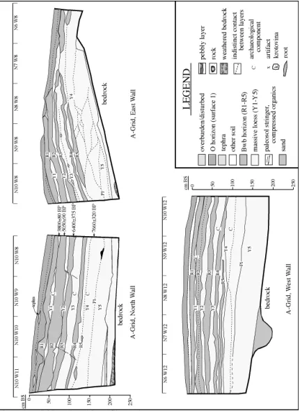
A-Grid
The A-grid (Figure 5) is associated with the majority of the artifacts from the Upper Locus. The A-grid north wall (Kimura 1989:211) is derived directly from the field profiles of N10/W8-11. The A-grid west wall (Kimura 1989:211) is not among the profiles provided to Holmes by Kotani. The west wall is not identified by coordinates, though the strata contacts are consistent with the corner of N10/W11 section (the north wall of A-grid). However, there are some discrepancies in strata identification, including three red layers in place of two in the north section and different end-of-excavation levels. The layer labeled r5 in the original north wall profile is designated y6b (“yellowish mottled”) in the north wall profile in Kimura et al. (1989).
Kotani's undated generalized profile is derived from the north wall of the A-grid (listed as 'major
excavation') from below the lowest red loess to the surface, but it does not correspond to the north wall of the 1985 excavations. It possibly represents the north wall from the 1983 excavations in the A-grid. In this profile, r1 is split into an upper and lower red loess (r1a and r1b). Y1 appears as a discontinuous loess layer in between r1a and r1b. Therefore, the sequence is r1a-Y1-r1b-Y2, etc.; this is different than the Kimura et. al. (1989) sequence which is Y1-r1a-r1b-Y2, etc.
Table 3 shows the published version of the general profile from the 1985 excavation, based on a four meter section (N10/W8-11). The original field drawing labels are in the second column, with the single
generalized profile labels provided by Kotani to Holmes. It is somewhat difficult to reconcile the generalized stratigraphic profile labels drawn by Kotani with the field profile labeled during the 1985 excavation – the latter are the source for the Kimura et al. (1989) general profile. Moreover, the Kimura profile labels have changed from the field notes to publication. These discrepancies are crucial to understanding the provenience of several radiocarbon dates.
developed; (3) R3 is continuous, well developed, and separated from R2 by continuous/discontinuous Y2; (4) Y3 is structurally complex with many thin organic stringers, charcoal concentrations and flecks, and compressed wood fragments; (5) R4 is continuous and well separated by Y3 and Y4 from R2 and R5 respectively; (6) R5 is discontinous and less developed than R4; (7) Paleosol 1 is discontinuous but appears in most profiles; (8) Bedrock was reached in most areas and sand layers directly overlay the bedrock; and (9) Artifacts were found associated with various layers (component designations are based on Kimura et al. 1989). There are inconsistencies in the provenience assigned to various components by Kimura et al. (1989) and Kotani (n.d.). Kimura et al. (1989) place the Upper component within R1, the middle component within Y3, and the lower component in Y4, and R4, whereas Kotani (n.d.) places the upper component within Y1, which in his profile divides R1, the middle component within Y3, and the lower component in Y4, R5, and Y5.
The strata tend to compress at the south of the A-grid as illustrated in the east wall profile, and in the 1978 excavations (see Figures 2 and 5). The A-grid east wall profile is consistent with the A-grid model using the same terminology for the original North wall; however, the southernmost area is difficult to discern. r4 (labeled) could be either R3 or R4, though most likely R3 given the discontinuous nature of R4. R1 and R2 have eroded, and Surface 1 and 2 remain.
No data relevant to artifact location is provided on the field profiles, but Kimura et al. (1989: 215-217) include three-dimensional graphs of artifacts recovered from the Upper Locus in 1985. From the vertical distributions, it is clear that these three components are separated and each has a unimodal vertical distribution. The upper component artifacts recovered in 1983 and 1985 consist of one black chert point base (of an unknown type), two obsidian secondary processing flakes, and a number of large flakes. One microblade was recovered from the middle component artifacts in 1983. Middle component artifacts recovered in 1985 include 64 flakes (primarily of black chert), one rhyolite sidescraper, and one endscraper of unstated material found in two pieces 10 cm apart. According to Kimura et al. (1989:213), charcoal excavated from this layer (Y3) dates to 5,050±90 BP (N-4958), though in the accompanying figures, this date is associated with R2 (1989: Figure 3 and Table 1). The lower component artifacts recovered in 1983 consist of three concentrations in the southern part of A-grid, including one microblade core, about 40 microblades, and 160 flakes. In the 1985 excavation, 80 microblades and about 1,400 flakes in four concentrations were recovered in the lower component. A large sample of artifacts was assigned material type designations, and these descriptions are consistent with Component III material types at the Lower Locus and material types recovered from the 1977 excavation. These are primarily black and gray chert, with small amounts of obsidian and rhyolite flakes (Kimura et al. 1989:209-213). Several clusters of bone, teeth, and charcoal were found in association with the lithic artifacts, but no data regarding these concentrations are presented in the 1989 report. The A-model correlates the upper component with Y1, the middle component with Y3, and the lower component with Y4.
B-Grid
The B-grid (Figure 5) is a continuation of A-grid to the west in the form of a trench seven meters long by 1-2 meters wide. The trench (N10/W16-19) was not excavated to the bedrock. There are several differences in the trench profile from the A-grid model as developed above: Y1 is not present, except at the extreme east, R3 consists of three thin red layers, and Y3 is not as complex, represented simply as a single yellow loess layer. Similarities with the A-grid model include: (1) general agreement on number, position, thickness, and continuity of the R layers, and (2) correlation of the tephras and Surfaces 1-2. The main B-grid (N10-11/W23) profiles consist of a west and east wall. Differences in these profiles from the A-B-grid model include (1) the separation of R3 into three thin red layers; and (2) absence of Surface 2. The sod appears to be equivalent to Surfaces 1 and 2 from the A-grid and general similarities include: (1) agreement on number, position, thickness, and continuity of the R layers; and (2) correlation of the tephra. Flakes are present within Y4, similar to the A-grid model, and probably represent the lower component, which has the largest number of artifacts within the A-grid excavated area.
C-Grid
generally thicker. Similarities with the model include: (1) a continuous R4 and discontinuous R5; (2) a complex Y3 with many charcoal fragments; and (3) an overall agreement of the R layers. No artifacts were recovered in C-grid. The conclusion is that the C-grid is consistent with the A-grid model.
E-Grid
The E-grid (Figure 5) is located 11 m west of C-grid, and 16 m west of B-grid. Differences with the A-grid model include: (1) R4 and R5 contact for a distance of 50 cm and a discontinuous Y4; (2) Y3 is not as complex; and (3) Y2 is more complex including many organic-rich layers. Similarities with the model include: (1) a general agreement of the R layers; (2) continuous R4; (3) discontinuous R5; and (4)
matching general thicknesses of R layers (i.e., R2 is the thickest, then R3, then R1). Bedrock was reached in this unit. Overall, E-grid appears consistent with the A-grid model.
G-Grid
The G-grid (Figure 6) is located 18 m west of E-grid, 29 m west of C-grid, and 34 m west of A-grid. Most of this unit is excavated to bedrock. It exhibits the most complex and unique strata at the Upper Locus, and indeed for the entire site. R5 appears to be better represented and more continuous, and thicker as it trends west (it was field labeled r9). Paleosols are not present, and strata from Y5 (field labeled as y9) and below appear compressed. Table 4 lists the original G-grid field labels, the A-grid model equivalent, and the various depths.
Though no data were presented on G-grid artifacts in Kimura et al. (1989), the plan-views of three components were recorded in the original field notes. Unfortunately, these maps are unlabeled, having small "x" marks that almost certainly represent flakes or microblades, and larger line drawings that might represent cobbles or bone fragments, but which are clearly associated with the flakes. The lowest component is associated with y8 (between R4 and R5) and consists of 16 x-marks and one larger object (either bone or large artifact). The middle component is associated with y2-r2 and consists of 279 probable lithic artifacts and ten larger pieces. The upper component is associated with y2 and consists of ten probable lithic artifacts and seven large objects. The upper component occurs in one concentration at S4, W58, whereas the middle component occurs two concentrations, the main cluster (n=190 probable lithic artifacts) at S2, W58, and a smaller one (n=60 probable lithic artifacts) at S3-4, W58. It is possible that given the complex thin layers at G-grid, and the partial spatial separation of the components, these artifacts may actually represent a single component. The A-grid model correlates the upper component with Y1, the middle component with R2, and the lower component with Y4.
Two interpretations can be made regarding unit designation. First, the G-grid labeled units of r1 are equivalent to A-grid model R1, y1 to Y1, and G-grid r2 through r5 to A-grid R2. An alternative
explanation is that G-grid r1 through r2 are equivalent to A-grid R1, G-grid Y2 is equivalent to A-grid Y1, and G-grid r3 through r5 is equivalent to A-grid R2. The lower units are as presented in Table 4. Both interpretations are consistent with the artifact distributions. The component labeled as “upper” by Kimura et al. (1989) is present within Y1 in the A-grid. Artifacts are present in both y1 and y2 (G-grid
designators). The second interpretation appears to be more likely, because r1 and r2 are combined for a longer distance (75 cm vs 20 and 30 cm), thus agreeing more closely with the A-grid model. Similarities with the A-grid model include: (1) the agreement of G-grid y7a-c with A-grid Y3 due of the presence of many organic stringers; (2) although r9 (equivalent to A-grid R5) is mainly continuous, it is much thinner than r8 (A-grid R4); (3) there is a general agreement with the R layers; (4) the tephra appears in a similar stratigraphic position; (5) Surface 1-3 are similar; (6) y8 (A-grid Y4) contains artifacts; and (7) y1 and y2 (A-grid Y1) contains artifacts. The conclusion for G-grid is the tentative acceptance of the A-grid model pending further investigation.
Test Pit 1
Holmes 1998:6). The strata labeled “disturbed A horizon” on the original profile probably correlates to Surface 2 and possibly to Surface 3. R1 to Y4 is identical to the model, while the "mottled red" is equivalent to R5, and "P" to P1. Similarities to the A-grid model include: (1) relatively similar sequence of R layers; (2) consistent artifact location at Y5; (3) R5 is continuous, but thinner than R4.
Dissimilarities with model include: (1) Y5/Y6 are listed above P1 (P1 should separate them); and (2) Y2 and Y3 appears more complex. The conclusion is acceptance of the A-grid model for this test pit.
Test Pit 2
Test Pit 2 (Figure 7) was excavated in 1996 and lies 24 m northwest of the A-grid. This excavation terminated at bedrock. Similarities with the A-grid model include: (1) general position agreement of the R layers; (2) R5 (labeled as "red silt stringer") is discontinuous; (3) Y3 is complex with many organic stringers; (4) the paleosol is discontinuous but present; and (5) the cultural component is in Y4 between R4 and R5. Differences with the model include: (1) cultural material in R4, perhaps related to the Y4 component; (2) absence of tephra; and (3) a compact olive brown silt lies near the bottom of the unit. A microblade core fragment was recovered at 114 cm below surface, but most artifacts were found between 125 and 140 cm below surface, within Y3 (see Holmes 1998:6). The stratum labeled "disturbed zone" appears to correlate to Surface 3. The conclusion is acceptance of the A-grid model.
Test Pit 3
Test Pit 3 (Figure 7) was excavated in 1996 and lies 35 m northwest of A-grid. No R or Y layer is labeled below R2. R3 is present in the form of three to four thin red loess layers. Y3 (not labeled here) contains many organic stringers. R4 and R5 are not labeled in the field profile, and R4 could be one red layer. The "A soil horizon" could represent Surface 2 and 3. No artifacts were recovered, but a Cervus tibia exhibiting tool cutmarks was found at 109 cm below surface in the lower part of R3 or Y3 (see Holmes 1986:6). R1 and R2 are only partially separated by Y1. R4 is continuous, but is apparently in direct contact with R5. The A-grid model holds for R4 and above, but is poor for the R4-Y4-R5 sequence.
Test Pit 4
Test Pit 4 (Figure 7) was excavated in 1996 and lies 25 m west of A-grid. Strata thicknesses differ from nearby C-grid and are similar to Test Pit 1. The test pit was not excavated to bedrock. Strata are not labeled below R2 but the correlation appears relatively straightforward here. The R1-Y1-R2 boundaries are indistinct and cannot be separated. The general stratigraphic sequence below R2 is consistent with the A-grid model. R3 is represented by two smaller red loess layers. A radiocarbon date of 6,220±80 BP (WSU-4892) was obtained from the upper part of R3, and is in good agreement with the date from the Bluff Test Pit and the interpretation of Holmes (1998) and Kotani (n.d.), but not with that of Kimura et al. (1989). Flakes were found at 137 cm below surface and 155 cm below surface, within the lower contact of R4/Y4 and the contact between Y4/R5 respectively (see Holmes 1998:6). It is unknown if these depths are means or point proveniences on single items, they may represent one or more components. Burned bone was found within the lower paleosol and this is the only occurrence of fauna associated with this stratum at the site. Bones were found within R4, similar to Test Pit 2. The stratum labeled "disturbed A horizon" probably represents Surface 2 and 3. The conclusion is that the A-grid model works well for R2 and below.
Test Pit 5
date of 8,280±60 (ß-98434) was associated with R4 (labeled in TP5 as r3), which is consistent with Holmes (1998) and Potter (2001b) dates but inconsistent with Kotani (n.d.) and Kimura et al. (1989). A date of 6,470±310 BP (WSU-4893) was associated with Y4 that is consistent with Kotani (n.d.) and Kimura et al. (1989) but inconsistent with Holmes (1998). A date of 10,040±60 BP (ß-98436) was associated with the paleosol (P1) that is consistent with all of the hypotheses. A notched pebble was found 60 cm below surface, within Y2, and boulder spalls, microblades, flakes, gastroliths, and bones were recovered from Y4 (see Holmes 1998:6). The conclusion is that the A-grid model works for the strata below R2 with the proviso that two of the dates appear too recent given the bulk of the other dates assuming that the associated strata are consistently identified, and several dates are inconsistent with at least one hypothesis.
1977 Excavation
The 1977 excavation (Figure 6) yielded 16 linear meters of stratigraphic profiles. These units were on the edge of the eroding bluff and situated immediately south of the 1983 and 1985 A-grid. For the purposes of this analysis, the 1977 units are considered part of the A-grid. There is apparently only one 1977 excavation unit adjacent to the 1985 excavation. Units N6W8 (east wall) and N5W8 (north wall) have one corner (NE) which adjoins the 1983 excavation A-grid. The only R layer appearing at that interface is R4. As the 1977 profile continues west, other upper R layers appear. Several differences are apparent between the 1977 and 1985 profiles. R1 is absent, there is no tephra or paleosol present, and artifacts are not confined to Y4. However, the stratigraphic profiles are in general agreement with the A-grid model. Similarities include (1) a general agreement on R layers, (2) composition of R2 (two red loess layers), somewhat similar to the A-grid west wall, (3) R4 is the lowest continuous R layer, and (4) absence of R5.
Artifacts recovered from R3 through R4 in the 1977 excavation are possibly derived from Y4, given strata compression near the edge of the bluff. These artifacts probably represent those appearing in the larger and more controlled excavations of Kotani in 1983 and 1985 as components located in Y4 and Y3 respectively. The upper cultural component described by Rabich and Reger (1978:I-4) was associated with Y1 (the mottled loess overlying the uppermost oxidized stratigraphic layer), which agrees with Kimura et al. (1989) and Kotani (n.d.). The lower component was associated with R3 and R4 (middle and lowest oxidized units), and the excavators note that "it is possible that there are two distinct components, but that the distribution of each overlaps" (Rabich and Reger 1978: I-4). Given the relative vertical proximity of the middle and lower components observed by Kimura et al. (1989) (see Figure 9), it is likely that Rabich and Reger recovered artifacts from both the middle and lower components in 1977. A radiocarbon date of 4,120±170 BP (Gx-4950) was obtained at 24-32 cm below the surface within soil unit 2 ("mottled loess"). This date, at the lower limit of Y1 is consistent with the 3,800±65 BP date on Y1 from the 1985
excavation and appears to be a good lower limiting date on the upper component. The conclusion is tentative acceptance of the A-Grid model though more work is needed on the provenience of the archaeological components.
Lower Locus
A total of 41 linear meters of profiles were drawn for the Lower Locus in the course of the 1999 and 2000 investigations (see Figures 8 and 9). An additional three meters with associated radiocarbon dates were provided in the 1996 investigation (Holmes 1998:7). Stratigraphic profiles include a 12 meter-long section parallel to the eroding edge of the bluff. The research design for the Lower Locus excavation in 1999 and 2000 entailed 4 m2 excavation blocks with vertical control provided by the stratigraphic profiles. The R layer designations of Holmes (1998) were used in the field. Excavation was conducted by natural strata from the surface to the R4/Y4 interface. Excavation below this interface was conducted in 10 cm
increments due to the lack of continuous stratigraphy. This served as an independent check and correlation with earlier work. Buried surface contours were noted, drawn, and measured.
received a greater influx of sediments over comparable time spans than has the Upper Locus, probably due to its location nearer the present Gerstle River and presumably the ancient river that flowed immediately south of the site. Though sediment analyses have not been completed for the Upper Locus, particulate size analysis of sediments at the Lower Locus indicate a greater proportion of sand from R1 to Y4. The vertical distance between R4 and bedrock is much longer, (3 meters vs 1 meter at the Upper Locus). A possible
Saiga tatarica humerus, and various Equus sp. remains, including a radiocarbon-dated radius (see below), eroding out of the lower sands suggest a late Pleistocene age for these lower sediments.
The original surface may be revealed in the profiles of Excavation Block G (Figure 9). R1 does not appear on any of the Lower Locus profiles, though it is possible that R1 is indistinct from R2 on the north wall of Excavation Block G. Pockets of tephra were found within the buried root mat in this block, perhaps indicating reworking or disturbance of the root mat. Given the limited amount of exposed undisturbed upper strata, it is difficult to interpret any sediments above Y1 at the Lower Locus.
All three radiometric dates from the 1996 Lower Locus tests correspond to Upper Locus dates. A date of 6,250±60 BP (ß-98435) was recovered near the top of R3, corresponding to similar dates from R3 at Test Pits 4 and the bottom of R3 at Test Pit 1. A date of 8,380±50 BP (ß-98433) recovered within R4 corresponds to a date from R4 at Test Pit 5. A date of 9,970±60 BP (ß-98432) on paleosol 1 corresponds to a date from P1 at Test Pit 5. A date of 7,325±200 BP (WSU-4894) was recovered from an unknown provenience at the Lower Locus and must be discounted due to this location ambiguity. Holmes (1998) dated an Equus sp. radius found eroding out of the lower sands to 15,150±70 BP (ß-109267), which probably offers a realistic age of the lower sediments at the Lower Locus.
Three archaeological components were recovered in clear stratigraphic contexts during the 1999 excavation. A hearth (Feature 1) associated with microblades, burins, scrapers, and retouched flakes from Component III (CIII) yields a radiocarbon date of 8,860±70 BP (ß-10206). A second hearth (Feature 5) from the CIII cross-section is visible on the north wall of N48E46 (Figure 8). CIII is separated from Component II (CII) by a discontinuous Bw horizon (R4). A hearth (Feature 2) associated with microblades and core fragments from Component II yields a radiocarbon date of 9,510±50 (ß-11108). This component is separated from Component I (CI) by a discontinuous sand layer (S1). The lowest component, CI, remains undated at present, though a lower limiting date of 9,740±50 BP (ß-133751) was obtained on the paleosol (P1) directly underlying CI artifacts. This date, when calibrated, corresponds to earlier dates on P1 at both the Upper and Lower Loci (11,228-11,112 cal BP vs. 11,912-11,223 and 12,096-11,257 cal BP). CI appears to be stratigraphically associated with a pebbly layer of limited dimension (Figure 8, N48E43-47;
N48E44). The stratigraphic, radiocarbon, and artifactual data at the Lower Locus are remarkably consistent given the multiple years of research, the complicated stratigraphy, and the absence of the uppermost strata due to previous anthropogenic disturbances.
RADIOCARBON DATING
There is congruity between the 1996 and 1999-2000 radiocarbon dates, and they may be considered more reliable for dating due to the precise associated provenience information in relation to the field profiles than are the earlier radiocarbon dates. With the exception of three dates within Test Pit 5 and one date with uncertain provenience at the Lower Locus bluff face, the remaining seven dates from these excavations (n=11) are internally consistent. As noted above, the lack of point provenience data for the radiocarbon samples obtained from the 1983 and 1985 excavations has played a large part in difficulties in interpreting stratigraphic relationships of the dated samples.
especially since the Y4-R4-Y5 sequence does not appear on the North wall of the A-grid according to Kimura et al. (1989: 211). In sum, the data do not appear to support the interpretation in Kimura et al. (1989).
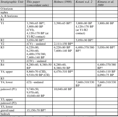
A list of all radiocarbon dates obtained from the Gerstle River Site is provided in Table 5. The concordant suite for the A-grid model at both loci is provided in Table 6 and Figure 10. Of the previous
interpretations considered, the data suggest that Holmes (1998) is the most parsimonious. The stratigraphic correlations of the A-grid model with the provenienced radiocarbon dates and associated archaeological component distributions generally support the chronology of Holmes (1998) but contradict those of Kotani (n.d.) and Kimura et al. (1989) who associate Y4 with dates ranging from 6,000 to 7,660 BP.
The stratigraphic distribution of the archaeological material support the delineation of six archaeological components present at both Loci at the site, and the radiocarbon dates are adequate for preliminary age estimates on four of the six components. Component I, located within Y4 and bounded by S1 and P1, has stratigraphic bracketing dates of 9,510±50 BP (CII) and 9,740±50 BP (P1) yielding an average of 11,200 cal BP. Component II, located within Y4 and bounded by R4 and S1, yielded a hearth date (Feature 2) of 9,510±50 BP (10,800 cal BP). Component III, located 10-20 cm below R4 within Y4, yielded a hearth date (Feature 1) of 8,860±70 BP (9,920 cal BP). Component IV, located within Y3, has stratigraphic bracketing dates of 8,280±60 BP and 7,600±140 BP, yielding an average of 8,200 cal BP. Component V, located within Y2, has stratigraphic bracketing dates of 6,220±80 BP and 5,050±90 BP, yielding an average of 6,300 cal BP. Component VI, located within Y1 and at the contact of Y1/R2, has a date of 3,800±80 BP (4,200 cal BP) associated with Y1 and a lower limiting date of 4,120±170 BP.
COMPONENT CHARACTERIZATIONS
Detailed artifact and faunal analyses are beyond the scope of this paper, but a summary can be given based on the published and unpublished reports at the Gerstle River Site (Holmes and Dilliplane 1976; Rabich and Reger 1978; Kimura et al. 1989; Holmes 1998; Potter 1999, 2000a, 2001a, 2001b) and the
stratigraphic correlations detailed above. Figure 10 illustrates the dating and position of each cultural component for both loci.
Component I
Component I (~11,200 cal BP) is found only at the Lower Locus, and consists of 282 unmodified flakes, one modified flake, a few scattered unidentifiable bone fragments, and 72 cobbles/boulders in stratigraphic association with the artifacts, perhaps representing a cobble feature or a natural colluvial feature.
Component II
Component II (10,800 cal BP) was found only at the Lower Locus, and consists of 361 unmodified flakes, two modified flakes, 102 microblades, one microblade core tablet, two microblade core facet rejuvenation flakes, one burin, and five burin spalls, in association with one firepit. The microblade core parts indicate that wedge shaped cores were reduced on site. No faunal remains were recovered with this component. This component is most similar to clusters A, B, C, G, and N at Dry Creek, Component II, and thus falls within Denali Complex parameters (Powers et al. 1983, West 1967).
Component III
Cervus and Bison, and a single worked rod of mammoth ivory (see Potter 2001b). Gastroliths are also present from the 1996 and 2000 excavations of this component. Component III is most similar to clusters A, B, C, G, and N at Dry Creek, Component II and also falls within Denali complex parameters (Powers et al. 1983, West 1967).
Component IV
Component IV, found only at the Upper Locus, consists of 200 unmodified flakes, one modified flake, eight microblades, one endscraper, and one side scraper. No faunal remains are found associated with this component. Due to the presence of microblades, absence of notched points, notched pebbles, semi-lunar bifaces, and the estimated date of 8,200 cal BP, this component is most closely affiliated to the Denali complex.
Component V
Component V (~6,300 cal BP) is represented by a single notched pebble in the Upper Locus only and cannot be securely attributed to any technological complex.
Component VI
Component VI (4,200 cal BP) was identified at both Loci, and consists of 75 unmodified flakes, four modified flakes, two endscrapers, one projectile point base [undescribed by Kimura et al. (1989], and one biface fragment. Several unidentifiable bone fragments were recovered at the Lower Locus in 1999. The artifact sample from this component is too small to derive technological affiliation, though the differences from the earlier components could indicate changes in site utilization between the early and middle Holocene.
Artifacts in Disturbed Contexts
In addition to artifacts found in situ, many were recovered in disturbed or surface contexts, including 442 unmodified flakes, five modified flakes, 23 microblades, one burin, one burin spall, three endscrapers (one burinated), two side scrapers, one boulder spall scraper, three bifaces, one projectile point fragment, and two hammerstones.
DISCUSSION
This effort to correlate the different stratigraphic profiles generated by various researchers at the Gerstle River over the past 25 years underscores the importance of producing detailed excavation reports. Further excavation at the Upper Locus will probably answer questions regarding artifact distribution and may shed light on the stratigraphic and dating problems of earlier researchers, but may not be able to reveal the actual stratigraphic position of the radiocarbon dates obtained during the 1983-1985 excavations. Soil auguring between the 1983-1985 excavation blocks and the 1996 test pits could resolve some of the stratigraphic problems. A number of new radiocarbon dates on precisely provenienced samples would help reconcile the various interpretations of the stratigraphic sequence in the Upper Locus; the resulting data would then in fact replace (rather than help reconstruct) the previous interpretations of radiocarbon dates and strata. As noted above, these correlations are provisional and should be tested as new analytical data in the form of testing, radiocarbon assays with good provenience, and new stratigraphic profiles become available.
Lithic, faunal, spatial, and sediment analyses are ongoing for the Lower Locus, and preliminary results indicate significant spatial patterning of artifacts, features, and fauna that probably delineate activity areas (Potter 2000). The plan-view data for the Upper Locus (A and G-grids) indicates that similar artifact clusters were encountered there, especially within Component III. The vertical distribution data from both loci suggests very little post-depositional disturbance and the coincidence of radiometrically dated
the cultural material recovered from 1999 to 2001 in their proper contexts within the site and within the region.
ACKNOWLEDGEMENTS
LITERATURE CITED
Bacon, G. H.
1987 A Cultural Chronology for Central Interior Alaska: A Critical Appraisal. Quarterly Review of Archaeology, pp 3-5.
Cook, J. P.
1969 The Early Prehistory of Healy Lake, Alaska. Ph.D. Dissertation, Department of Anthropology, University of Wisconsin, Madison.
1996 Healy Lake. In American Beginnings: The Prehistory and Palaeoecology of Beringia, edited by F. H. West. University of Chicago Press, Chicago.
Cook, J. P., and R. A. McKennan
1970 The Athapaskan Tradition. A View From Healy Lake in the Yukon-Tanana Upland. Paper presented at the 10th annual meeting of the Northeastern Anthropological Association, Ottawa.
Dilley, T.E.
1998 Late Quaternary Loess Stratigraphy, Soils, and Environments of the Shaw Creek Flats Paleoindian Sites, Tanana Valley, Alaska. Ph.D. thesis, University of Arizona.
Dixon, E.J.
1999 Bones, Boats, and Bison: Archeology and the First Colonization of Western North America.
University of New Mexico Press, Albuquerque.
1985 Cultural Chronology of Central Interior Alaska. Arctic Anthropology 22(1):47-66.
Erlandson, J., R. Walser, H. Maxwell, N. Bigelow, A. Higgs, and J. Wilber
1991 Two Early Sites of Eastern Beringia: Context and Chronology in Alaska Interior Archaeology.
Radiocarbon 3(1):35-50.
Hamilton, Thomas D., and Ted Goebel
1999 Late Pleistocene Peopling of Alaska. In, Ice Age Peoples of North America: Environments, Origins, and Adaptations, edited by Robson Bonnichsen and Karen L. Turnmire. Oregon State University Press, Oregon.
Holmes, C.E.
1998 Archaeological Testing and Evaluation of the Gerstle River Quarry, East-Central Alaska, 1996. Office of History and Archaeology Report No. 65, Department of Natural Resources.
Holmes, C.E., and T.L. Dilliplane
1976 Report of Archaeological Survey Along the Alaska Highway Including a Brief History of the Highway. In, Archaeological Survey Projects, 1976, pp. VII1-VII18, Miscellaneous Publications, History and Archaeology Series No. 16, Alaska Division of Parks.
Kimura, Y., T. Nishimoto, and Y. Kotani
1989 Three-Dimensional and Attribute Debitage Analyses of Stone Chips. Bulletin National Museum of Japanese History and Ethnography 21:207-238.
Kotani, Y.
n.d. Composite generalized profile: Gerstle River Quarry Site. MS in possession of the author.
Kra, R. R., and M. Stuiver (eds.)
1986 12th International Radiocarbon Conference, Trondheim, Norway, 1985, Proceedings, Radiocarbon
28(2).
Lively, R. A.
1988 A Study of the Effectiveness of a Small Scale Probabilistic Sampling Design at an Interior Alaska Site, Chugwater (FAI-035). Unpublished report on file, U.S. Army Corps of Engineers, Alaska District, Anchorage.
Maitland, R. E.
1986 The Chugwater Site (FAI-035), Moose Creek Bluff, Alaska. Final Report, 1982 and 1983 Seasons. Unpublished report on file, U.S. Army Corps of Engineers, Alaska District, Anchorage.
Mason, Owen K., Peter M. Bowers, and David M. Hopkins
2001 The Early Holocene Milankovitch Thermal Maximum and Humans: Adverse Conditions for the Denali Complex of Eastern Beringia. Quaternary Science Reviews 20: 525-548.
Potter, B.A.
1999 1999 Gerstle River Quarry Site (49XMH-246) Archaeological Excavation Preliminary Report. Report prepared for Delta-Greely School District.
2000a 2000 Gerstle River Quarry Site (49XMH-246) Archaeological Excavation Preliminary Report. Report prepared for the State Office of History and Archaeology.
2000b Microblade Assemblage Variability: New Data from the Gerstle River Quarry Site, Central Alaska. Paper presented at the Sixty-fifth annual Meeting of the Society for American Archaeology, Philadelphia, Pennsylvania.
2001a 2001 Gerstle River Site (49XMH-246) Archaeological Excavation Preliminary Report. Report prepared for the State Office of History and Archaeology.
2001b Recent Investigations at the Gerstle River Site, a Multicomponent Site in Central Alaska. Current Research in the Pleistocene, Vol. 18: 52-54.
Potter, B.A., and C.E. Holmes
2000 Gerstle River Quarry Site, a Multi-component site in the Tanana Basin. Paper presented at the Twenty-seventh annual Alaska Anthropological Association conference, Anchorage, Alaska.
Powers, W.R., R.D. Guthrie, and J.F. Hoffecker
1983 Dry Creek: Archaeology and Paleoecology of a Late Pleistocene Alaskan Hunting Camp. Report to the National Park Service, Washington, D.C.
Rabich, J.C. and D.R. Reger
1978 Archaeological Excavations at the Gerstle River Quarry Site. In, Archaeological Survey Projects, 1977, pp. I1-I37, Miscellaneous Publications, History and Archaeology Series No. 18, Alaska Division of Parks.
West, F.H.
1967 The Donnelly Ridge Site and the Definition of an Early Core and Blade Complex in Central Alaska. American Antiquity 32(3):360-382.
1996 Beringia and New World Origins II. The Archaeological Evidence. In American Beginnings: The Prehistory and Palaeoecology of Beringia, edited by F. H. West, pp. 537-559. University of Chicago Press, Chicago.n
Yesner, D. R.
Table 1. Stratigraphic data
Unit Description
O horizon Sphagnum moss mat at the Upper Locus, absent at Lower Locus
A horizon silt, dark grayish brown (10YR 4/2), cumulative A horizon. A light brownish gray (10YR 6/2) tephra overlies the A horizon.
B horizon silt, dark yellowish-brown (10YR 4/4), B horizon of modern cryochrept soil R(ed)1-5 silt loess, reddish-brown (7.5 YR 4/4), discontinuous Ab horizons overlying Bwb
horizons, consisting of decomposed organic material and abundant charcoal fragments; lower contacts generally wavy and grading, upper contacts generally horizontal and sharp. Y(ellow) 1-6 aeolian silt, grades from silt (Y1, Y2) to sandy loam (Y3, Y4) to sand (Y6), yellowish
brown (10YR 5/4), massive, with compressed wood stringers and continuous and discontinuous charcoal lenses, some rootlets.
S15 medium sand, discontinuous at the Lower Locus, not present at the Upper Locus (2.5Y 6/4)
Paleosol 1 silt loess, Abk horizon, paleosol complex Paleosol 2 silt loess, Abk horizon, very discontinuous
Lower Sand sand, yellowish brown (10 YR 6/2), angular pebbles near the base of sand at contact with underlying bedrock
Bedrock weathered granodiorite in grus matrix, grayish-brown (10 YR 5/2)
5
Table 2. Stratigraphic profile summary data.
Group Linear meters ordinal direction(s) Source
A-Grid 13 N, W, E walls original field notes (N, E walls); Kimura et al. 1989 (N, W walls); Kotani n.d. (N wall)
A-Grid 3 N wall continuation original field notes
B-Grid 3 N, E walls original field notes
C-Grid 3 N, E walls original field notes
E-Grid 3 N, W walls original field notes
G-Grid 7 N, E walls original field notes
TP 1-5 11 various original field notes; Holmes 1998
1977 Excavation
16 N, W, E walls Rabich and Reger 1978
Bluff Test Pit 3 N, E walls original field notes; Holmes 1998 1999-2000
Excavations
Table 3. A-Grid stratigraphic correlations
Field Profile Depth (N wall) cm BS
field profile label (N wall)
Kimura et al. 1989 label (N and W walls)
Kotani n.d. label (N wall of "major excavation") Depth from Kotani n.d. cm BS A-Grid Model
0-10 Surface 1 Surface 1 O horizon
10-12 tephra tephra tephra
12-18 Surface 2 Surface 2 A horizon (B
horizon?)
18-24 r1 Surface 3 r1b 5-23 R1
24-29 Y1 Y1 -3800 BP Y1 (3800 BP,
4120 BP at lower contact)
23-33 Y1
29-48 r2 r1a-b r1a (5050 BP) 33-45 R2
48-60 Y2 Y2 Y2 45-57 Y2
60-65 r3 r2 (5050 BP) r2 (6400 BP) 57-72 R3
65-90 Y3 Y3 Y3 72-82 Y3
90-96 r4 r3 (6400 BP) r3 82-91 R4
Y4 (not present on N wall) (6040 BP, 6090 BP) r4 (not present on N wall)
n/a n/a
y5 -7660 BP (not present on N wall)
n/a n/a n/a
96-110 Y4 y6a Y4 91-116 Y4
110-115 r5 y6b -on west
wall (must be a mistake as it is noted as red in the field profile)
r5 ~100 R5
115-150 Y4 y6c Y5 -7660 BP Y5
150-151 P P P1 paleosol 1
Table 4. G-grid stratigraphic correlations
G-grid depth G-grid label A-grid equivalent A-grid depth notes
0-15 1 (surface) Surface 1 0-10
15-20 2 (tephra) tephra 10-12
20-27 3 (surface) Surface 2 12-18
27-35 r1 R1 18-24
35-40 y1 Y1 24-29 cultural material
40-48 r2
48-50 y2 cultural material
50-62 r3
62-63 y3
63-78 r4
78-82 y4
82-88 r5
R2 29-48
88-100 y5a-b Y2 48-60
100-110 r6
110-115 y6
115-120 r7
R3 60-65
120-140 y7a-c Y3 65-90
140-163 r8 R4 90-96
163-170 y8 Y4 96-110 cultural material
170-175 r9 R5 110-115
175-213 y9a-c Y5, Y6? 115-151+
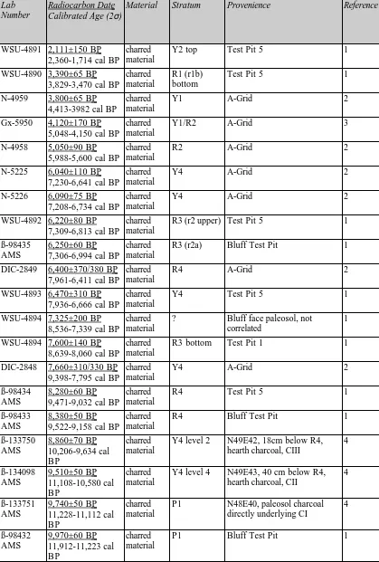
Table 5. Radiocarbon dates at Gerstle River
Lab Number
Radiocarbon Date Calibrated Age (2σ)
Material Stratum Provenience Reference
WSU-4891 2,111±150 BP 2,360-1,714 cal BP
charred material
Y2 top Test Pit 5 1
WSU-4890 3,390±65 BP 3,829-3,470 cal BP
charred material
R1 (r1b) bottom
Test Pit 5 1
N-4959 3,800±65 BP 4,413-3982 cal BP
charred material
Y1 A-Grid 2
Gx-5950 4,120±170 BP 5,048-4,150 cal BP
charred material
Y1/R2 A-Grid 3
N-4958 5,050±90 BP 5,988-5,600 cal BP
charred material
R2 A-Grid 2
N-5225 6,040±110 BP 7,230-6,641 cal BP
charred material
Y4 A-Grid 2
N-5226 6,090±75 BP 7,208-6,734 cal BP
charred material
Y4 A-Grid 2
WSU-4892 6,220±80 BP 7,309-6,813 cal BP
charred material
R3 (r2 upper) Test Pit 5 1
ß-98435 AMS
6,250±60 BP 7,306-6,994 cal BP
charred material
R3 (r2a) Bluff Test Pit 1
DIC-2849 6,400±370/380 BP 7,961-6,411 cal BP
charred material
R4 A-Grid 2
WSU-4893 6,470±310 BP 7,936-6,666 cal BP
charred material
Y4 Test Pit 5 1
WSU-4894 7,325±200 BP 8,536-7,339 cal BP
charred material
? Bluff face paleosol, not correlated
1
WSU-4894 7,600±140 BP 8,639-8,060 cal BP
charred material
R3 bottom Test Pit 1 1
DIC-2848 7,660±310/330 BP 9,398-7,795 cal BP
charred material
Y4 A-Grid 2
ß-98434 AMS
8,280±60 BP 9,471-9,032 cal BP
charred material
R4 Test Pit 5 1
ß-98433 AMS
8,380±50 BP 9,522-9,158 cal BP
charred material
R4 Bluff Test Pit 1
ß-133750 AMS 8,860±70 BP 10,206-9,634 cal BP charred material
Y4 level 2 N49E42, 18cm below R4, hearth charcoal, CIII
4 ß-134098 AMS 9,510±50 BP 11,108-10,580 cal BP charred material
Y4 level 4 N49E43, 40 cm below R4, hearth charcoal, CII
4 ß-133751 AMS 9,740±50 BP 11,228-11,112 cal BP charred material
P1 N48E40, paleosol charcoal directly underlying CI
4 ß-98432 AMS 9,970±60 BP 11,912-11,223 cal BP charred material
ß-98436 AMS
10,040±60 BP 12,096-11,257 cal BP
charred material
P1 Test Pit 5 1
ß-109267 AMS
15,150±70 BP 18,635-17,518 cal BP
Equus radius
Disturbed context
Lower Locus: disturbed context, most likely from sand unit underneath Y5
1
Table 6. Site Chronology (uncalibrated radiocarbon years BP)
Stratigraphic Unit This paper (concordant suite)
Holmes (1998) Kotani n.d. 2 Kimura et al. 1989
O horizon tephra A, B horizons R1
Y1 3,390±65 BP?,
3,800±80 BP (CVI),
4,120±170 BP (at Y1/R2 contact)
3,390±65 BP? 3,800±80 BP 4,120±170 BP (at Y1/R2 contact)
3,800±80 BP
R2 5,050±90 BP? 5,050±90 BP?
Y2 (CV) – undated 2,111±150 BP*
R3 6,220±80, 6,250±60, 6,400±370/380, 7,600±140 BP 6,220±80 BP 7,600±140 BP 6,400±370/380 BP? 5,050±90 BP?
Y3 (CIV) – undated
R4 8,280±60, 8,380±50
BP
8,280±60, 8,380±50 BP
6,400±370/380 BP?
Y4, upper 8,860±70 (CIII), 9,510±50 BP (CII)
6,470±310 BP* 6,040±110 BP
6,090±75 BP R5
Y4, lower (CI) –undated 7,660±310/330
BP
7,660±310/330 BP
paleosol (P1) 9,740±50, 9,970±60, 10,040±60 BP 10,040±60 BP Y5, upper paleosol (P2) Y5, lower
gravel/sand 15,150±70 BP? bedrock