International Journal of Computer & Organization Trends (IJCOT) – Volume 7 Issue 6- Nov to Dec 2017
Architecture and Realization of Web
Geographic Information System with the
Layer Display and Data Editing Function
Kim JongGun#1, Choe JongAe#2, Ri KwangSong#3, Mun NamChol#4 #
Institute of Information Science, Kim Il Sung University, Pyongyang, D.P.R. of Korea
Abstract
A new architecture of WGIS (web geographic information system) for the realization of rational geo-spatial data management and high speed of map service is proposed, and the architecture of GI (geographic information) server, which is the core element, is considered. And then the working structure of web SIS (spatial information service) in the GI server and the method for high-speed SIS are considered. By using this WGIS farmland management is realized and compared with other for evaluation. The suggested architecture of this system can be effectively used in building a national or regional WGIS in different fields of the national economy such as forestry, power, traffic, aviation and so on. Meanwhile the high-speed web GI service will greatly contribute to performing real time GI analysis and necessary measurements.
Keywords — Web GIS, OpenGEO, DBMS (Database Management System)
I. INTRODUCTION
Typical WGIS include ArcGIS, MapXtreme, MapGuide, GeoMedia Web Map and so on [14, 15]. ArcGIS is an application and development software of geographic information system (GIS), based on internet. ArcGIS has different ESRI service techniques and data-connecting methods [1]. ESRI Shape files and DBMS data are available in ArcSDE which is used as the map source database in ArcGIS. Mujabar et al. (2010) have realized a coastline geographical data system by using ArcGIS [2].
Meanwhile, web spatial data service has been realized by OpenGEO, the collection of software [3]. OpenGEO is the combination of GeoServer [16], GeoWebCache, and OpenLayers [17]. GeoServer is a geographical data server in the form of open source code, which supports different web spatial information standard services such as WMS [19], WFS, WCS [18]. In GeoServer, ESRI Shape files and DBMS data can be used as map source data. GeoWebCache is a map caching server that can increase web map service speed by
performing high-speed tile-caching (TC) processing, and works as a Proxy between server-side and client-side. OpenLayers is a web client library that can produce map images in client, and it supports different SIS such as WMS, WFS, WFS-T [4].
Techniques for the high speed of SIS include tile-processing technique and TC technique. Tile-processing technique provides speedy and flexible map browse [5]. TC technique provides speedy map browser and helps to decrease communication and processing loads [7, 8]. Generally, TC processing is done in server-side and client-side of a single-layer WMS request processing method [6].
The high speed of web SIS such as web map service and web feature service is realized by combining these techniques [9]. Most web SIS is realized by GI server that has introduced high-speed processing technique and web map client library [10, 11, 12, 13].
Our goal is to build a system that can perform map caching service for web map service request including several layers in GeoWebCache and can satisfactorily perform the display and control of several layers in OpenLayers. The paper builds and realizes high-speed WGIS that has layer-displaying and data-editing function.
II. ARCHITECTURE
The high-speed WGIS, which has layer-displaying and data-editing function, needs the following requirements.
First of all, it should be able to perform map caching service corresponding to multi-layer WMS requests. Next, it should have layer-displaying function in client-side and high-speed SIS function. And it should have functions of browsing, search, measurement and map-editing, and should be able to convert ESRI Shape files into DBMS form.
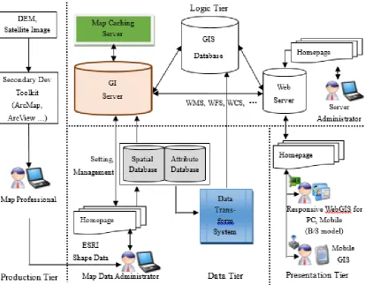
Figure 1: Architecture of the High-Speed WGIS With Layer-Displaying and Data-Editing Function
A. Tiers
The production tier is the one in which the production expert produces maps by map-production tools (ArcMap, ArcView and others) with DEM data or satellite pictures as a source.
In the data tier, the GI service manager registers ESRI Shape files, that is, geographical spatial data and property data in a geographical data server, converts ESRI Shape files into DBMS form before loading them on a database server, and manages all kinds of service-setting data and map data for a GI server.
The logic tier is composed of GI server, database server, web server. Here all sorts of web SIS such as WMS, WFS, WCS are done.
The logic tier is the main part that deals with requests of client and performs all sorts of GI service. In this tier the most important element is the GI server. Map caching server which can speed up web map service by expanding TC is combined with GI server.
The presentation tier provides client users with different map-based information services such as browsing, editing, search, analysis, measurement, decision making.
In the high-speed WGIS which has layer-displaying and data-editing function, the user tier is composed of map-production expert, GIS server
users in each tier do work corresponding to their roles and authorities.
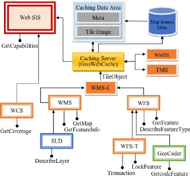
Figure 2: Architecture of GI Server in a Logic Tier
B. Architecture of GI Server in a Logic Tier
The GI server, the core element in a logic tier, performs the most important and central role. GI server provides all kinds of SIS to client users, in cooperation with web server and database server. GI server is composed of map data processing tier, SIS tier, TC processing tier, and security tier. (Figure 2)
1) Map Data Processing Tier
International Journal of Computer & Organization Trends (IJCOT) – Volume 7 Issue 6- Nov to Dec 2017
groups, SLD files that are interrelated to each other and have common properties. The store describes geographical spatial information (GSI) sources such as GeoTiff, Shape files, database and so on. The store has the properties of the path and format of source files, address of database, database user’s name and password and so on. Layer has the property that instructs how to display on the screen the data source for one geographical spatial object. Layer has the properties such as source coordinate, output coordinate, boundary coordinate values, necessary SLDs, format of output pictures, coordinate for producing caching data, the range of scales and so on. Layer group is a group of several layers, and it helps to deal with several layers like in one layer in client-side. SLD defines all sorts of styles for displaying point, polyline, polygon, text, raster data.
2) SIS tier
This is for web SIS provided by Open Geospatial Consortium (OGC). Generally request and response for GSI are realized through WMS, WFS, WFS-T, WCS and the spatial data service installed in GI server. Meanwhile, TC is done for fast speed of web SIS, and this work is done by TC service and TC module such as WMS-C, WMTS, TMS. WMTS does tile production and display according to map scale, client-side visible range and map display range, and WMS-C stores and displays the produced data for the concerned scale and position as caching data.
3) TC Processing Tier
This tier does tile processing and caching process for the map-SIS with web SIS for TC. By the TC processing tier, tile images produced according to scales and display ranges for tiled layers, are stored in server, and response-tile images are sent to client after the requests are analyzed. Here caching data area is for storing tile images produced in server. In the Gridset Module, scales and display ranges and tile sizes are set for TC. Tile layer module can produce in advance the tile images in caching data area for tiled layers, and store and manage the tile images.
4) Security Tier
GI server manages GSI and does all sorts of web SIS and settings, so it needs strict security. Security tier chooses security policy for users, defines authorities and roles, and performs security process according to them.
C. Combining Structure of SIS in GI server
GI server’s essential task is to conduct web SIS. GI server performs geographical spatial service such as WCS, WMS, WFS, WFS-T, and performs
tile and caching services such as WMS-C, WMTS, TMS. These services are correlated to one another to process for client requests and performs web SIS. The combining structure of the web SIS in the GI server is the same as in Figure 3.
As shown in Figure 3, WMS combines with SLD to perform map image production service. And WFS combines with WFS-T to perform feature information service.
One of the important parts is the tile and caching service.
GI server performs SIS for TC such as WMS-C, WMTS, TMS, and performs TC service by caching server. Generally, WMTS and TMS turn the map source data into tiles and respond the requests of client.
And WMS-C responds the requests and does caching for WMS and WFS, and combines with caching server for high-speed response to the WMS, WFS, and WFS-T requests. Caching server analyzes Tile Object sent from WMS, WFS, WFS-T, and investigates caching data area, and if the requested file exists, it immediately sends the tile image stored in the caching data area to client, and if it does not exist, it investigates map source data, produces tile image, and stores it in caching data area before sending the produced image to client.
The above constructed WGIS system has the following advantages.
It can support all the standard functions of web GI service and install different professional functions in a convenient way.
It can realize service environment of distributed system structure, and support all web SIS which are provided from OGC.
It can transmit standard raster data and vector data.
GSI supports all ESRI Shape files and DBMS data structure, and installs data converting function independently.
By combining WMS, WFS, WFS-T services and map caching server, it can perform TC during map image service and also the map editing service.
It has 4-tiered structure composed of ESRI Shape file producer, GI server manager, server manager, and common client user, so it can perform flexible security and authority management.
Figure 3: Combining Structure of SIS in GI Server
III. FLOWCHART
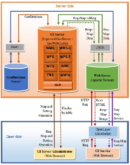
Request and response procedure between the server-side and client-side, and between the servers is the same as in Figure 4.
A. Procedure of Dealing with Request
The procedure between server-side and client-side is as follows:
The client user sends all kinds of map service request and HTTP request to the web server by web browser for GI service.
The web server deals with the received request and sends a map image response by means of web map client library.
Client-side deals with standard request/response for map service by means of OpenLayer, which is the web map client library designed with JavaScript.
GI service manager requests for map data and request for map service setting operation, to the geographical data server by web browser designed for GI server.
GI server sends the result of request in the form of tables.
Web server sends a request for map data to GI server. This request includes ones related with map service such as map image and map editing.
GI server analyses the request from the web server and sends a map data response.
Web server process for data operation between web server and database server.
GI server deals with the map data request of the web server by OGC web spatial data service.
International Journal of Computer & Organization Trends (IJCOT) – Volume 7 Issue 6- Nov to Dec 2017
Figure 4: Flowchart of Suggested WGIS
B. Procedure for the High Speed of Spatial Data Service in a GI Server.
To make SIS faster in a GI server means to minimize the time spent for processing the request of client WMS and WFS-T and the time needed for producing response.
The procedure between server-side and client-side for the fast processing of multi-layer WMS request and WFS-T request is introduced below.
1) Procedure of the Web SIS in Client- Side
The procedure for dealing with WMS request is as follows.
The user selects the necessary map layers, scales and display range by using browser-control.
In client-side, tile coordinates within display range are calculated by using scales and display range, and multi-layer WMS requests for each tile are listed.
If there is a corresponding image within the cache, it displays it, and if there isn’t, it sends the request to server.
It sends to server WMS request of multi-layer including non-tile layers.
As seen above, it realizes the combination of multi-layer WMS request, tile request and TC processing during the WMS request transmission.
WMS response procedure is as follows.
When it receives WMS response for tile layers, it displays it on the screen and adds it to tile cache.
When it receives WMS response for non-tile layers, it overlays it on the tile images. The procedure of dealing with WFS-T request is as follows.
It receives edit layer, edit operation, edit condition and edit data from edit controller.
It sends the received data to server.
The procedure of dealing with WFS-T response is as follows.
After it has received WFS-T response, if the edited feature data is smaller than threshold, it deletes tile images including edited data, and when it is bigger, it reproduces all tile images in the concerned map layer.
It displays all WFS-T result to the user and performs re-browsing of the screen range. As seen above, it realizes the combination of web map service and web feature editing service while dealing with WFS-T response.
2) Procedure of Web SIS in Server-Side
The procedure of dealing with WMS request accompanying the TC for multi-layer WMS request in server-side is as follows.
First of all, it receives multi-layer WMS request that is composed of only tile layers or non-tile layers from client.
Next it divides the multi-layer WMS request into a single-layer WMS requests.
For individual single-layer requests, if it is a request for tile, it checks if there is a corresponding tile image within the tile cache. If there is a tile image, it loads, and if not, it produces tile image from map data source and stores it in a tile cache.
If it is the request in which the single-request does not deal with the tile, it produces a map image from the map data source.
It makes a response image by overlaying map images from each layer and sends it to client. The procedure of dealing with the WFS-T request in server-side is as follows.
It changes the map data corresponding to the editing request.
When the number of edited data is greater than threshold, it produces all the tile images of necessary layers in the tile cache, and if it is smaller, it reproduces only the tile images containing changed data.
The features of web spatial data service depending on the above-mentioned procedure is as follows.
It keeps to the web SIS standard that is provided from OGC.
It inherits tile-making techniques and web SIS functions that are provided from OpenGEO, WGIS software group of open source, and further improves them.
It provides WMS which is combined with the processing of multi-layer WMS request and TC.
It provides WFS-T which is combined with TC processing.
It entirely guarantees the compatibility between the improved web SIS functions and the standard service functions.
IV. REALIZATION AND DISCUSSION
A. Realization
Nowadays WGIS is widely used in almost all fields of life including agriculture and traffic. In agricultural sector, they are developing web-based GIS that can be used for the survey of spatial distribution and interrelationship of soil, feature and climate, and land management and so on.
The suggested WGIS is the fast system that has layer-display and data-editing function, and can be used for farmland management.
1) Module Architecture
The module architecture of this system has 2 parts: server-side and client-side.
Server-side module architecture
Server-side is composed of 7 main modules: GI management, data conversion, database management, SIS, TC, security and authority management, request processing.
GI management module manages the geographical spatial data, which is the main part of the system. To be more exact, it can register and update layer and layer group, spatial data including raster and vector data, SLD, and coordinates.
Data conversion module can convert ESRI Shape files into DBMS data such as MySQL and Oracle. Database management module manages the database server.
SIS module performs web SIS. In other words, it includes geographical spatial services such as WCS, WMS, WFS, WFS-T and tile and caching service modules such as WMS-C, WMTS, TMS.
TC module performs TC in server-side. In other words, it defines caching data area for storing caching data in server-side, defines grid for caching work, and deals with caching data depending on tile layers and management.
Security and authority management module deals
exact, it deals with user management for web server and GI server, security policy, authority and authority group, role management.
Request processing module deals with client requests. That is, it can receive requests of the client-side, and analyze, respond and transmit them.
Client-side module architecture
The client-side performs 7 main modules: map data browsing, spatial data editing, mark management, measurement, search, analysis, and expert function.
Map data browsing module can browse map data. That is, it includes map display function that can show map image, property data, panorama image, and reduced map browsing function, map’s movement, expansion and reduction, layer selection function.
Spatial data editing module can edit GSI and property data.
Mark management module manages mark on the map by means of system mark and user mark. Mark is put in a certain position according to the user’s opinion, and it can store user information, all sorts of feature information and others.
Measurement module measures distance and area on the map.
Search module can proceed with a simple search for GSI, a comprehensive search and a search for positions by area names.
Analysis module performs buffering analysis, overlaying analysis and others.
Expert function module can proceed with all kinds of functions of expert level, such as fertility evaluation, facility management, object management and so on.
2) Analyzing Function
WGIS for farmland management has a function for analyzing the land and farming.
The function for analyzing the farmland includes soil analysis, feature analysis, and weather condition analysis. The function for analyzing the soil can do index-based analysis and statistical analysis of acidity, humus content, nitrogen content, phosphor content, potassium content, kind of soil, granule condition, specific soil layer, inner layer structure, surface material thickness, humus thickness, soil depth, dry-wet condition, underground water depth, rock and sedimentary items. The function for analyzing the topography can do index-based analysis and statistical analysis of topography class, topography region, height, angle of inclination, length of inclination, direction items. Weather analysis function can analyze index-based and statistical analysis of the first, second, and third ten-day temperature of months, average temperature.
International Journal of Computer & Organization Trends (IJCOT) – Volume 7 Issue 6- Nov to Dec 2017
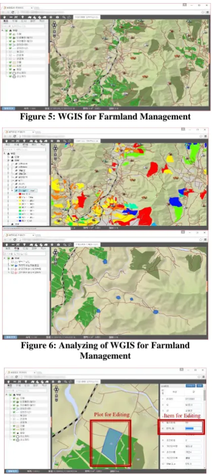
Figure 5: WGIS for Farmland Management
Figure 6: Analyzing of WGIS for Farmland Management
Figure 7: Editing of WGIS for Farmland Management
The function for analyzing experts can browse and analyze caching area, proceed with overlaying analysis, reservoir site analysis, and drainage way area analysis. Caching area analysis function can search for other objects around the specific object. Reservoir site analysis can browse and analyze the reservoir sites within an area being displayed. Drainage way area analysis function can browse and analyze farmland or grassland within the drainage area.
The result of suggested WGIS is shown in Figure 5~7.
This system has display-and-control function for several layers, so users can control any displayed layers. (Figure 5, 6) The user can edit the properties of any object of any layer, and can immediately identify the result on the map. (Figure 7)
GI server manager can proceed with different kinds of settings for GI service by means of exclusive GI server, and can manage map spatial information source data on layer basis.
B. Discussion
The expert analysis functions for the suggested WGIS, web SIS and spatial analysis are compared with previous system (Table 1).
Table 1: The Comparison of Functions with Previous System
OpenGEO Suggested WGIS
OS of Server Windows, Linux, UNIX… Windows, Linux
WebServer Apache Tomcat
Server
Apache Tomcat Server
Image Format for network transmission
raster(JPEG/GIF) ,vector
raster(JPEG/GIF) ,vector
Map Data Format
ESRI Shapefile, ArcGrid, GeoTiff, MySQL,
PostGIS
ESRI Shape file, ArcGrid, GeoTiff, MySQL,
PostGIS
Function for converting into
DBMS form
× ○
Layer selection
function ○ ○
Function for editing
spatial data ○ ○
TC processing when
editing in client-side × ○
And the number of responses to requests and the amounts of communication are compared.
The server used for evaluation is Core I5 2.6GHz-class normal desktop-PC and network cable is 100Mbps Ethernet. The client computer is Core 13 2.4GHz and the screen size is 1024×768 (pixel). The size of tile is 256×256(pixel). The number of simultaneous requests from client-side is 10, and the number of request-process thread is 8.
The comparison results of communicational amounts between two methods: the standard multi-layer WMS request processing method in OpenGEO and the above suggested method is shown at table 2. As seen at table 2, in case of using the suggested method the amount of communication is much smaller than using the previous one.
Table 2: Comparison of the Number of Responses to Requests and Amount of Communication
Numbers of responses to requests
Amounts of communication
(MByte) First
browsing Re-browsing
First browsing
Re-browsing Previous
Method 21 21 1.2 1.2
Suggested
Table 3 shows the comparison of average times for processing WMS and WFS-T request, memory usages and data storage capacities in server-side. Here the average time of processing WMS and WFS-T request is evaluated by the time that takes to display the map image on client-side screen after it has been transmitted. The memory usages of the server is the average amount of memory used at the moment of processing the requests. The data storage capacity in the server means the space of the hard disk used for storing TC images and for responding the requests.
Table 3: Comparison of Average Times for Processing Request, Memory Usages and Data Storage Capacities
in Server-Side average time for processing WMS request (ms) average time for processing WFS-T request (ms) memory usages in server-side (MB) data storage capacity in server-side (GB) First brow sing Re- brows ing Previ ous Meth od
2013 2013 2058 978.43 6.39
Sugge sted Meth od
799 362 614 2706.62 108.75
From the above experimental result, we can confirm that in case of using the suggested method the time for processing request is 29.17% shorter than using the previous method.
The average memory usage of the server is 2.76 times larger and the total data storage capacity is 17.01 times larger.
V. CONCLUSIONS
From the above results, about the proposed WGIS we conclude as follows.
A new architecture of high-speed WGIS with layer-display and data-editing function has established by introducing the method of realizing its tier building, working procedure, method of building GI server and web SIS.
It has updated the function of managing map spatial information by implementing the function for converting a new data between ESRI Shape files and DBMS data structure.
It has updated the function of TC service of the GI server.
It combines the caching server which was managing only WMS service with WFS and WFS-T
of map caching service and to increase the function of caching server.
But the proposed method has the problem that average usage of memory and hard disk capacity increase. This problem will be solved in the future.
REFERENCES
[1] Booth, B., & Mitchell, A. (1999), Getting started with ArcGIS, ESRI, Redlands, CA.
[2] Mujabar, S. P., & Chandrasekar, N. (2010), Web based coastal GIS for southern coastal Tamilnadu by using ArcIMS server technology, International Journal of Geomatics and Geosciences, 1(3), pp.649-662.
[3] Tsou, M-H. & Smith, J. (2011), Free and Open Source Software for GIS education”, White Paper Department of Geography, San Diego State University.
[4] Davis, S. (2007), GIS for Web developers: Adding Where to Your Web Applications, The Pragmatic Bookshelf, Raleigh. [5] Huisman, O., & De By, R. A. (2009), Principles of geographic information systems, ITC Educational Textbook Series 1.
[6] Xu, H., Hou, X., Cai, H., Su, R., & Ni, Q. (2009), Online Geographic Information Service Platform Based On Google Earth, International Conference on Hybrid Intelligent Systems, 2, pp.345-348.
[7] Leichun, W., Jihong, G., & Shuigeng, Z. (2004), Building GIS Web Services on JXTA Network, Geo-spatial Information Science, 7(4), pp.268-273.
[8] Boulos, M.N.K., Warren, J., Gong, J. & Yue, P. (2010), Web GIS in practice VIII: HTML5 and the canvas element for interactive online mapping, International Journal of Health Geographics, 9(1), 14
[9] Sun, L., He, D., & Zhao, P. (2015), A Research of Publishing Map Technique Based on Geoserver, Asian Journal of Applied Sciences, 8, pp.185-195.
[10] Friis-Christensen, A., Lutz, M., Ostlander, N. & Bernard, L. (2007), Designing Service Architectures for Distributed Geoprocessing: Challenges and Future Directions, Transaction in GIS, 11(6), pp.799-818.
[11] Gkatzoflias, D., Mellios, G. & Samaras, Z. (2013), Development of a web GIS application for emissions inventory spatial allocation based on open source software tools, Computers & Geosciences, 52, pp.23-29
[12] Wenjue, J., Yumin, C., & Jianya, G. (2004), Implementation of OGC web map service based on web service, Geo-spatial Information Science, 7(2), 148-152.
[13] Wu, J., Amaratunga, K. & Chitradon, R. (2002), Design of Distributed Interactive Online Geographic Information System Viewer using Wavelets, Journal of Computing in Civil Engineering ASCE, 16(2), pp.115-123.
[14] Fazal, S. (2008), GIS Basics, Delhi: New Age International. [15] Su, Y., Slottow, J. & Mozes, A. (2000), Distributing
proprietary geographic data on the World Wide Web – UCLA GIS Database and Map Server, Computers & Geosciences, 26(7), pp.741-749.
[16] Deoliveira, J. (2008), GeoServer: uniting the GeoWeb and spatial data infrastructures, In Proceedings of the 10th International Conference for Spatial Data Infrastructure, St. Augustine, Trinidad.
[17] Hazzard, E. (2011), Openlayers 2.10 beginner's guide, Packt Publishing Ltd.
[18] Baumann, P. (2010), The OGC web coverage processing service (WCPS) standard, GeoInformatica, 14(4), pp.447-479.