Maria Engracinda dos Santos Ferreira
a,*, Luciene Stamato Delazari
ba Federal University of Paraná, Geodetic Sciences Graduate Program, [email protected] b Federal University of Paraná, Geodetic Sciences Graduate Program, [email protected]
* Corresponding author
Abstract: Spatially describing objects or environments is a natural and everyday task present in the daily lives of individuals. To portray the existing relationships between present elements of the scene described, it is necessary to use terms known as spatial relations. Frequently, such descriptions are performed using Natural Language (NL), both spoken and written. The existence of a constant interaction of human with the environment makes NL rich in terms that characterize space, resulting in a diversity of such words. The variety of terms used as spatial relations makes it difficult to implement spatial localization systems that use NL. Therefore, to understand how spatial relations are used, the present article aimed to detect and categorize such spatial relations. For this, an experiment of a spatial description of environments unknown by users was performed. The volunteers were native speakers of Brazilian Portuguese language and from the spatial descriptions were obtained locative expressions that allowed the definition and categorization of spatial relations using the Spatial Image Schemata. The results obtained demonstrated an attempt to understand the spatial relations used in spatial descriptions. In the future, we aim to define a set of spatial relations representative of the words used in a spatial description task.
Keywords: Spatial Relations; Locative Expressions; Spatial Image Schemata.
1. Introduction
In the process of communicating through spoken or written Natural Language (NL), places or events are described using expressions such as “the drugstore is in front of the gas station”. This type of description is the predominant way of communication among human beings and it is known as locative or locational expressions (Herskovits 1985; Hall et al. 2015; Kim et al. 2017). Herskovits (1985) describes locative or locational expression as any spatial expression composed of a sentence with a spatial term and its object. In other words, it is a phrase where the link between two or more nouns (objects or people) is established by a spatial relation (terms).
The use of spatial concepts occurs in an unpremeditated way, that is, their application occurs spontaneously by people. This is possible because any human being is capable of reasoning spatially, a characteristic that differs us from other living beings (Landau & Jackendoff 1993; Kracht 2002). Human's ability to decode geographic information favours the creation of mental spatial representations, which are cognitive representations of knowledge acquired about the environment, with its meanings and the relative positions of persons or objects in the space through of the use of the spatial relations (Darken and Peterson 2001; Montello 2002; Hassani e Li 2017). In the formation of cognitive maps, information taken from the environment is filtered or selected by the sensory organs. This is only possible because the human mind is extremely active in acquiring information and it
has abilities as efficiency in recognizing the meanings of objects and generating spatial associations between the elements of the environment (Golledge 1993).
After the selection of the information, occurs the recognizing of patterns. Later, the information is organized and stored in the short-term memory (Blades and Spencer 1986). This information will be retrieved or represented to be used as a resource in performing spatial tasks when that information matches those stored in long-term or permanent memory. If the information stored in the permanent memory contributes to an understanding of the visual scene, it can be said that there was an integration between the elements of the environment with the observed scene or object, thus aiding in the construction of knowledge (Peterson 1987; Sternberg and Sternberg 2012; Johannes et al. 2015). Therefore, it is possible to say that previous experience with real world’s objects or features stored in the memory contributes to assign concepts to the new visual experiences experienced.
of knowledge (MacEachren 1995). For this reason, it is understood that the description of the position of a geographic element, that is, the way that locative expressions are elaborated, reflects the organization of the spatial knowledge represented in the cognitive map of the individual that makes it (Richter and Klippel 2005). Frequently, the spatial relations it is not clearly understood by systems that search to process and to represent such spatial descriptions (Egenhofer and Mark 1995; Mark and Egenhofer 1995; Mark an Freundschuh 1995). For this reason, the study of the meaning of spatial relations emerges as an important area of research in some branches of science, such as Linguistics, Geographic Information System (GIS), Cognition and Artificial Intelligence (AI) (Egenhofer and Franzosa 1991; Fisher and Orf 1991; Egenhofer and Mark 1995). In the area of geoinformation, spatial relations play a relevant role in spatial data modelling, spatial query and analysis. Regarding the activities of spatial cognition, spatial relations assist in the spatial reasoning and in the understanding of the maps (Hall and Jones 2008; Zhang et al. 2013; Hall et al. 2015). Realizing the relevance of spatial relations, researches on spatial relationships mainly aim to understand how people use them in their daily lives by performing spatial descriptions. In other words, they search for the users' understanding of spatial organization among objects and how they describe those organizations through NL and then implement formal models of spatial relations in GIS (Shariff et al. 1998; Tomai and Kavouras 2004). A factor that hinders the understanding of the spatial relations used in locative expressions is its versatility since the same spatial relation is used to describe several configurations among elements (Hall and Jones 2008). Therefore, it is necessary to understand the process of categorization of spatial relations used in locative expressions. A theory used to explain individuals' mental processes was proposed by Lakoff (1987) and Johnson (1987) and is called Image Schemata Models. Johnson (1987, cited in Freundschuh and Blades, 2012) provides the following partial list of schemata, to clarify how the image schemata structures our knowledge: Container, Surface, Counter Force, Matching, Mass-Count, Path, Iteration, Near-Far, Splitting, Verticality, Balance, Full-Empty, Restraint Removal, Enablement, Collection, Link, Process, Scale, Part-Whole, Compulsion, Blockage, Object, Attraction, Superimposition, Centre-Periphery, Cycle, Contact, Merging.
From this list, Johnson (1987) and Lakoff (1987) identify seven image schemata as being spatial: surface, near-far, verticality, path, link, and center-periphery. These schemas can be described in terms of (1) bodily experiences, (2) structural elements, (3) a basic logic, and (4) metaphorical extensions (Freundschuh and Blades, 2012).
This work aims to categorize the spatial relations used in the task of spatial description of an unknown environment according to Spatial Image Schemata. This is because spatial imagery schemes are central to spatial cognition and to how humans perceive, categorize and represent the world (Freundschuh and Blades, 2012).
2.
Methodology
Spatial descriptions are known as locative or locational expressions. For Hall et al. (2015) spatial descriptions are composed of entities which report the spatial position of objects or persons in relation to another reference element. This research presents the results of a survey performed with users in order to identify the spatial relations used in spatial descriptions of unknown environments. Afterward, using the Spatial Image Schemata, such relations were categorized.
2.1 Experiment
The experiment was conducted using photos of urban environments in egocentric view, in other words, a set of photos in which the four views of the place are shown, one picture in each direction. The photos used in the experiment were extracted from images provided by Google Street View of the Brazilian cities of Curitiba and Uberlândia, located respectively in the states of Paraná and Minas Gerais. Photos of the city of Auckland in New Zealand were also used. Nine regions were chosen, with four regions in Brazil and five regions in Auckland. Four regions are residential (one in Curitiba, one in Uberlândia and two in Auckland), four regions are central/commercial (one in Curitiba, one in Uberlândia and two in Auckland) and one region is non-urbanized in the city of Auckland.
2.2 Participants
Students of the undergraduate courses in Civil Engineering, Cartographic and Surveying Engineering, Environmental Engineering, Electrical Engineering, Mathematical and the Graduate Program in Geodetic Sciences (Federal University of Paraná - UFPR), were volunteers for the experiment with the photos of the cities of Curitiba and Uberlândia. For these photos, a sample of 52 users was obtained to perform the requested task, which occurred in the months of April and May of 2016. The survey with the photos of the city of Auckland was applied in the months of March to May of 2017. It was obtained a sample of 51 users with diverse academic backgrounds, including Cartographic and Surveying Engineering, Mathematics, Graphic Expression, and Geography, from different educational institutions, such as Federal Institute of Sergipe (IFSE), State University of Rio de Janeiro (UERJ), Federal University of Paraná (UFPR), among others.
2.3 Method
Figure 1. Center/commercial area photographs presented to the users for the spatial description task in an unknown environment.
To accomplish the task, the street name indications were removed from all the photos. Figure 2 presents the photographs presented from the residential area of the city of Uberlândia.
Figure 2. Residential area photographs presented to the users for the spatial description task in an unknown environment.
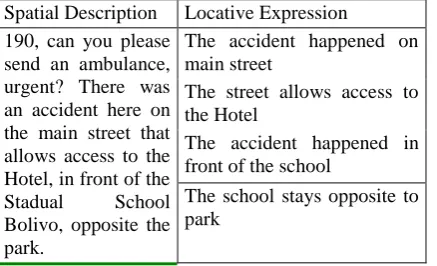
Initially, to avoid using spatial descriptions of users familiar with the presented environments, care was taken to verify if their naturalness corresponded to the described regions. In addition, the answers that showed signs of recognition of the place by the user were discarded. For instance, in a description, a user cited a non-visible landmark in the picture, thus showing familiarity with the environment. After the survey the spatial description were analysed. Initially, the spatial descriptions of each user were grouped by central/commercial and residential regions. Afterwards, they were dismembered with the purpose of obtaining the locative expressions. Table 1 presents an example of dismembered spatially description in locative expressions.
Spatial Description Locative Expression 190, can you please
send an ambulance, urgent? There was an accident here on the main street that allows access to the Hotel, in front of the Stadual School Bolivo, opposite the park.
The accident happened on main street
The street allows access to the Hotel
The accident happened in front of the school
The school stays opposite to park
Table 1. Example of spatial description performed out to the central/commercial region of Uberlandia with its local expressions
This procedure made it possible to identify the obligatory components of the locative expressions: spatial relation,
relatum and locatum. Spatial relations are used in locative expressions to describe the relationships between the elements present in the environment. Consider the phrase 'the accident happened in front of the school'. In this sentence, 'accident' is the element to be located and 'school' is the reference element for the user. In the literature, the element 'accident', in other words, the feature that is being positioned is called locatum. The feature in relation to which the locatum is being located, in the given example 'school', is known as the relatum. And 'in front of' is the spatial relation used to associate these two elements (Herskovits 1985; Schockaert et al. 2005; Hall and Jones 2008; Tenbrink and Kuhn 2011). Thus, for the spatial description presented in Table 1, we have the following components for each locative expression:
Locative Expression Locatum Spatial Relation
Relatum
The accident happened on main street
accident on main street
The street allows access to the Hotel
street allows access
Hotel
The accident happened in front of the school
accident in front of
school
The school stays opposite to park
school opposite to
park
Table 2. Components of the locatives expressions
The function of these components is related to the purpose of the locative description, in other words, to inform the location of an element, as in the cited example. Therefore, it is possible to say that locative expressions provide spatial information since characteristics of the elements present in the environment and the spatial relations among these elements are described (Li et al. 2011). The dismemberment of the locative descriptions into locative expressions allows us to identify the spatial relations used by the users in this experiment and then categorize them according to the Spatial Image Schemata.
3.
Results and discussion
way of persons' communication: for example, the first user briefly describes the environment: “I am in front of a State School Bueno Brandão. In front of a square”. In contrast, another user performs a richer description: “I am close to the State School Bueno Brandão, next to this school has several hotels. There is a square in front of the school. Taking as direction North of the School has a restaurant called “Sabor da carne”, in the direction South there is a hotel called Hotel Square”. Consequently, the different levels of difficulties encountered in the fragmentation of spatial descriptions in locative expressions are evident. Whereas in the first sentence the identification of the components was easily carried out, in the second one, the process of distinction and separation was more time consuming and complex.
Comparing the two examples, it can be seen that spatial descriptions can be simple or complex. In the latter, a greater number of spatial relations was used (Stock 2010). Thus, size is a characteristic of spatial descriptions (Denis et al. 1999) and the number of information contained varies according to people's cognitive experiences (Landau and Jackendoff 1993; Stock 2010).
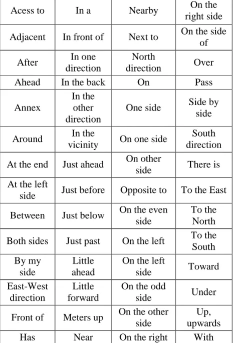
The constant interaction of human with the environment makes NL rich in spatial linguistic expressions that characterize space (Tomai and Kavouras 2004). Table 3 corroborates with the statement since 56 spatial relations were used for describing the relationships existing among features presents in the environment. That is, a significant number of spatial relations used by users in the spatial description task was observed.
Acess to In a Nearby On the
right side
Adjacent In front of Next to On the side of
After In one direction
North
direction Over
Ahead In the back On Pass
Annex
In the other direction
One side Side by side
Around In the
vicinity On one side
South direction
At the end Just ahead On other
side There is At the left
side Just before Opposite to To the East
Between Just below On the even side
To the North
Both sides Just past On the left To the South By my
side
Little ahead
On the left
side Toward
East-West direction
Little forward
On the odd
side Under
Front of Meters up On the other side
Up, upwards
Has Near On the right With
Table 3. Spatial relations used in spatial descriptions
Terms used as spatial relations are versatile. In other words, the same spatial relationship is used to describe various configurations among elements (Hall and Jones 2008). The results obtained in this research solidify this assertion since different spatial relations were used to describe a certain spatial arrangement, as shown in Table 4.
Locative Expressions The school is nextto the hotels. It has several hotels near the school. The school is between the hotel and the bar.
The school is on the side of the hotel. Table 4. Examples of different spatial relations used to describe the same spatial relationship
The table above presents the locative expressions involving the elements 'school' and 'hotel' present in the spatial descriptions of the commercial/central region of Uberlândia. For this region, 17 spatial descriptions were obtained, and of these, only 6 users described the relationship between 'school' and 'hotel' using 4 different terms: 'next to', ‘near, 'between' e ‘on the side of '. The inverse also occurs, in other words, the same spatial relationship can be used to describe different spatial configurations. In the examples shown in Table 5, the spatial relation 'next to’ is used to describe 4 relationships existing in the photographs of the central/commercial area of Uberlândia.
Locative Expressions The square is next to a hotel The hotel is next to the restaurant
The accident was next a square The buildings suggest being next to the
downtown
Table 5. Same spatial relations used to describe different spatial relationship
Given the versatility and quantity of terms used to characterize the relationship among elements in the environment, it is necessary to categorize such spatial relations. For this, the Spatial Image Schemata Models proposed by Johnson (1987) and Lakoff (1987) were used. This because metaphorical projections of schemata can capture the meaning of abstract concepts, and allow us to reason with them (Johnson 1987, cited in Raubal, 1997). The categorized spatial relations by Spatial Image Schemata in each schemata model are:
just ahead, just before, just past, little ahead, little forward, meters up, near, nearby, next to, pass.
2. Verticality: this schema encompasses the spatial relationships used when individuals qualitatively compare distances or when they need to move from one place to another (Raubal, 1997). The spatial relationships used by the individuals in the experiment reported in this paper that are part of this scheme are: Up, upwards.
3. Center-periphery: In this schema, one could use the egocentric referential, in which the individual is the center and observes different elements in the periphery, or the allocentric referential, in which the elements compose the subject’s environment (Raubal, 1997). The spatial relations are: access to, adjacent, around, in the vicinity, opposite to.
4. Path: This image schema is built upon the following structure: a starting point, an endpoint, and a connection between these points (Raubal, 1997). The spatial relations are: at the end, at the left side, both sides, by my side, East-West direction, front,in front of, in the other direction, in one direction, in the back, North direction, one side, on one side, on other side, on the even side, on the left, on the left side, on the odd side, on the other side, on the right, on the right side, on the side of, side by side, South direction, to the East, to the North, to the South.
5. Containers: This schema represents the idea of containment, in which there are an inside, an outside, and a boundary (Raubal, 1997). The spatial relations are: in a, on, has, there is.
6. Surface: This scheme is commonplace and people need it all the time while standing or walking (Raubal, 1997). The spatial relations obtained that fit this schema are: just below, under, over
7. Link: In this scheme, people relate connected objects via links and can occur in both the spatial and temporal experiences of individuals (Raubal, 1997). The spatial relations obtained that fit this schema are: toward, with.
The categorization was performed considering the importance of spatial imaging schemes, since they help individuals to relate previous experiences with current environmental understandings and in the relevance of these schematas for spatial applications (Kuhn and Frank 1991; Raubal 1997; Rüetschi and Timpf 2005).
4.
Conclusions
This work addressed the task of distinguishing and categorizing spatial relations present in spatial descriptions of environments unknown to the user. This approach was motivated by the variety and versatility of the spatial relations existing in the Portuguese language of Brazil, making it difficult to implement all the terms in
geographical location systems. As has been seen, spatial descriptions provide spatial knowledge of a particular place, as people transmit the information, in which it is based on their perception or memory. Such information allows communication between individuals in a satisfactory way, and consequently, people rely more and more on location based on a description in dialogue-driven geolocation services (Kim et al. 2017). Thus, the project in which this research is part, "Where Am I?" aims to implement an application in which it is possible to convert a spatial description into a geographic position. For this, it is initially necessary to identify and categorize the spatial relations used in spatial descriptions. Therefore, the present article gives the first step in the understanding and definition of a set of spatial relations to be implemented in systems that seek to process and present the geographical information obtained in NL. For this, the descriptions were broken down into locative expressions in order to detect the spatial relations used to describe spatial configurations presented in the photographs. Subsequently, these terms were categorized according to Spatial Image Schemata. The results presented reinforce the relevance of the Spatial Schemata Image model in the study of spatial relations for spatial applications since the categorization performed can helps in the understanding of how individuals establish a connection between different experiences with recurrent structures.
In accordance with the argumentation presented, this work configured an attempt to group the spatial relations into categories. In the future, It is intended to define spatial relations representative of words used in the task of spatial description, to be implemented in a geographic location system.
Acknowledgements
Authors thank the Brazilian National Council for Scientific and Technological Development (CNPq - Grant 310312/2017-5)
References
Blades, M. & Spencer, C., 1986. The Implications of Psychological Theory and Methodology for Cognitive Cartography. Cartographica, 23(4), pp.1–13.
Darken, R.P. & Peterson, B., 2001. Spatial orientation, wayfinding and representation. Handbook of Virtual Environment Technology, 4083(2001), pp.1–22. Denis, M. et al., 1999. Spatial discourse and navigation:
An analysis of route directions in the city of Venice. Applied Cognitive Psychology, 13(2), pp.145–174. Egenhofer, M.J. & Franzosa, R.D., 1991. Point-set
topological spatial relations. International Journal of Geographical Information Systems, 5(2), pp.161–174. Egenhofer, M.J. & Mark, D.M., 1995. Modelling
Freundschuh, S. & Blades, M., 2012. The Cognitive Development of the Spatial Concepts NEXT, NEAR, AWAY and FAR. Lecture Notes in Geoinformation and Cartography, (199629), pp.43-62.
Fisher, P.F. & Orf, T.M., 1991. An investigation of the meaning of near and close on a university campus. Computers, Environment and Urban Systems, 15(1–2), pp.23–35.
Golledge, R.G., 1993. Geographical Perspectives on Spatial Cognition. Advances in Psychology, pp.16–46. Hall, M.M. & Jones, C.B., 2008. Quantifying spatial
prepositions. Proceedings of the 16th ACM SIGSPATIAL international conference on Advances in geographic information systems GIS 08, p.1.
Hall, M.M., Jones, C.B. & Smart, P., 2015. Spatial Natural Language Generation for Location Description in Photo Captions. In Proceedings of the 12th International Conference on Spatial Information Theory – COSIT. New York, pp. 196-223.
Hassani, K. & Lee, W., 2017. Disambiguating Spatial Prepositions Using Deep Convolutional Networks. In Proceedings of Thirty-First AAAI Conference on Artificial Intelligence. pp. 3209–3215
Herskovits, A., 1985. Semantics and Pragmatics of Locative Expressions. Cognitive Science, 9(3), pp.341– 378.
Johannes, K., Wang, J. J., Papafragou, A. & Landau, B. 2015. Similarity and variation in the distribution of spatial expressions across three languages. In Proceedings of 37th Annual Meeting of the Cognitive Science Society. pp.997–1002.
Kracht, M., 2002. On the Semantics of Locatives. Linguistics and Philosophy, 25(1995), pp.157–232. Kim, J., Vasardani, M. & Winter, S. 2017. Similarity
matching for integrating spatial information extracted from place descriptions. International Journal of Geographical Information Science, v. 31, n. 1, pp. 56–80. Kuhn, W. and Frank, A.U., 1991. A formalization of metaphors and images-schemas in user interfaces. Cognitive and Linguistic Aspects of Geographic Space, 63, pp.1–15.
Lakoff, G., 1987. Woman, Fire, and Dangerous Things: what categories reveal about the mind. US: The University of Chicago Press, pp. 614.
Landau, B. & Jackendoff, R., 1993. What and Where in spatial language and spatial cognition. Behavioral and Brain Science, 16, pp.217–238.
Li, X. et al., 2011. Describing spatial locations from perception and memory: The influence of intrinsic axes on reference object selection. Journal of Memory and Language, 65(2), pp.222–236.
MacEachren, A., 1995. How Maps Work: Representation, Visualization and Design, New York: The Guilford Press.
Mark, D. & Freundschuh, S., 1995. Spatial Concepts and Cognitive Models for Geographic Information Use.
Cognitive Aspects of Human-Computer Interaction for Geographic Information Systems, pp.21–28.
Mark, D.M. & Egenhofer, M.J., 1995. Topology of prototypical spatial relations between lines and regions in english and spanish. In Proceedings of Auto Carto 12, Charlotte, North Carolina, March 1995, pp.245–254. Montello, D.R., 2002. Cognitive Map-Design Research in
the Twentieth Century: Theoretical and Empirical Approaches. Cartography and Geographic Information Science, 29(3), pp.283–304.
Peterson, M.P., 1987. The Mental Image in Cartographic Communication. The Cartographic Journal, 24(1), pp.35–41.
Raubal, M., 1997. Structuring Wayfinding Tasks with Image Schemata. Thesis. University of Maine.
Richter, K. F. & Klippel, A., 2005. A model for context-specific route directions. Spatial Cognition IV. Reasoning, Action, Interaction: International Conference Spatial Cognition 2004, 3343, pp.58–78.
Rüetschi, U.-J. & Timpf, S., 2005. Using Image Schemata to Represent Meaningful Spatial Configurations. In OTM Confederated International Conferences “On the Move to Meaningful Internet Systems.” pp. 1047–1055.
Schockaert, S., De Cock, M. & Kerre, E.E., 2005. Automatic acquisition of fuzzy footprints. Lecture Notes in Computer Science (including subseries Lecture Notes in Artificial Intelligence and Lecture Notes in Bioinformatics), 3762 LNCS, pp.1077–1086.
Shariff, A.R.B.M., Egenhofer, M.J. & Mark, D.M., 1998. Natural-Language Spatial Relations Between Linear and Areal Objects: The Topology and Metric of English- Language Terms. Mark International Journal of Geographical Information Science, 12(3), pp.215–246. Sternberg, R.J. & Sternberg, K., 2012. Cognitive
Psychology 6th ed., USA: Wadsworth Learning, Cengage.
Stock, K., 2010. Describing Spatial Relations using Informal Semantics. In Proceedings of GIS Research UK. London, pp. 14–16.
Tenbrink, T. & Kuhn, W., 2011. A model of spatial reference frames in language. In N. Egenhofer, M. J. Giudice, R. Moratz, & M. Worboys, eds. Spatial Information Theory: 10th International Conference, COSIT. Belfast, ME, USA, pp. 371–390.
Tomai, E. & Kavouras, M., 2004. “Where the city sits?” Revealing Geospatial Semantics in Text Descriptions. In 7th AGILE Conference on Geographic Information Science. Heraklion,Greece, pp. 189–194.