Practical Implementation of Mobile-based Online ILFS
Resources Evaluation
Dia M. Ali
University of Ninevah
Mosul / Iraq
Ali H. Saeed
University of Ninevah
Mosul / Iraq
ABSTRACT
Indoor Location Finding Systems (ILFS) have gained tremendous interest in the last few years because the indoor environments are growing larger and more complex continuously. ILFS are based on communication networks, and the fast growth of these networks had a significant and useful impact on developing these systems, where the variety of communication networks was reflected upon the manufacturers of (ILFS) and led to a large number of algorithms, techniques and measuring metrics to be used for ILFS.
In this paper, practical implementation of some of the well-known ILFS that can provide reasonable accuracy and avoid the complexity and high-cost constraints ware achieved. Two systems ware built, the first system is RF scene analysis based system which uses the cluster. The adopted platform was the regular Smartphone. The results show that the K-NN, WK-NN, COP, and RPM easily implement in the mobile platform without any significant degradation of the performance of the mobile. Around 33% of the CPU usage and only 1.2 % of RAM usage can be considered acceptable.
General Terms
Indoor Location Finding.Keywords
Mobile, Indoor Location Finding System (ILFS) ,K-NN.
1.
INTRODUCTION
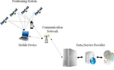
The modern life today is developing rapidly, and the environments are growing more complex every day, to cope with these developments, new technologies and services are adapted and deployed into the communities. An example of such services is the Location Based Services (LBS) as in Figure(1) which integrate the location of a mobile device with other information to provide different types of services to a user [1]. LBS has many applications nowadays, and it is expected to enter many other fields in upcoming future.
Fig 1: LBS Infrastructure Components [1]
[image:1.595.370.512.463.608.2]Some of the common applications of LBS are, acquiring about the nearest business, recommending social events, finding people on a map, turn by turn navigation [2]. As the word "location" indicates, LBS require accurate positioning (the words location and position are used interchangeably in this paper as they both refer to the coordinates of a target) to be completely functional. Global Navigation Satellite Systems (GNSS) shown in Figure (2) have gained a great deal of attention in the last two decades because of a large number of applications that require positioning and navigation. But these systems are satellite-based and therefore can't provide services in Indoor environments. Also, they suffer from performance degradation in dense urban cities and near large buildings due to the absence of the Line of Sight (LOS) link between the satellites and the device on the ground, which causes multipath, shadowing and weak signal reception issues. This means that GNSS can't provide service (or provide services with relatively high error percentage) in some environments, especially that these environments are always inhabited with people and there is always a need for an LBS, so the need to design a new system to compensate for the weaknesses of outdoor positioning systems (GNSS) in closed environments has become crucial.
Fig 2: GPS satellite constellation
Indoor positioning systems provided a solution for these environments, where new technologies, measuring metrics and special algorithms have been investigated and developed to provide very reliable services bearing in mind the financial and computational cost.
[image:1.595.86.273.622.737.2]need (3-4) RP only to find the location's coordinates and in this case the RP are known as Beacons, in other system, the RPs are recorded and stored in large datasets and the location is calculated by comparing readings recorded from the site with the dataset, this type of systems require a large number of RPs and they are called Fingerprints. However, in both types of the systems, the accurate distribution of the RP is very important to ensure a correct and reliable performance. In any typical positioning system, the coordinates of the point of interest are estimated by considering the displacement and/ orientation between that point and a set of RP that belong to the system used for positioning. To accomplish this task a direction and/ distance measurements are required at the point of interest.
The design of radio-based positioning systems involves the use of different distance-/direction-dependent measurements, such as, Received Signal Strength (RSS), Angle of Arrival (AOA) and signal propagation time which may be used in two methods, Time of Arrival (TOA) and Time Difference of Arrival (TDOA). In some cases, angular and time measurements are combined in a mixed algorithm to improve the performance of the system [3].
The factors that affect the propagation of RF signals in any environment are quite diverse such as multipath and shadowing, but in indoor environments, there are three other factors that are added to the signal which influence the accuracy of the positioning system, these factors are relative humidity, people blocking, and opening or closing of doors [4]
There are two types of deployments that govern the design of any position detection system, client-based, and infrastructure-based deployment. In a client-based deployment, a tag (the device that needs to be located) receives the radio signal from multiple beacons/ RPs (points with known locations used as references) to calculate the location by itself, while in an infrastructure based deployment, a group of beacons/RPs collect the signal measurements from tags and send them to a central server for position estimation [5].
2.
INDOOR LOCATION FINDING
CHALLENGES
The main challenge can be summarized as:
A) The standards and regulations of ILFS are not completely established yet because of the diversity of the systems, algorithms, and techniques used in location finding, also the continuous variations in indoor environments make it more difficult to set general rules and guidelines for building the system[6,7].
B) The fact that there are so many technologies and techniques that can be applied to the indoor positioning system made each organization, company or institute embraces a mythology of its own and builds a positioning system to fit their standards[8, 9].
C) The increasing number of applications and services that rely on accurate indoor positioning systems (such as military applications, medical emergencies, employees tracking, etc.)
D) The financial benefits of the companies that develop and supply ILFS which is expected to grow massively in the few coming years. IDTechEx (a company specialized in market research reports and consulting in high growth
technology areas) expects the global Real-Time Location Systems (RTLS) market to increase to $2.58 Billion in 2019, while it was $153 Million in 2009[10].
3.
PROPOSED APPROACH
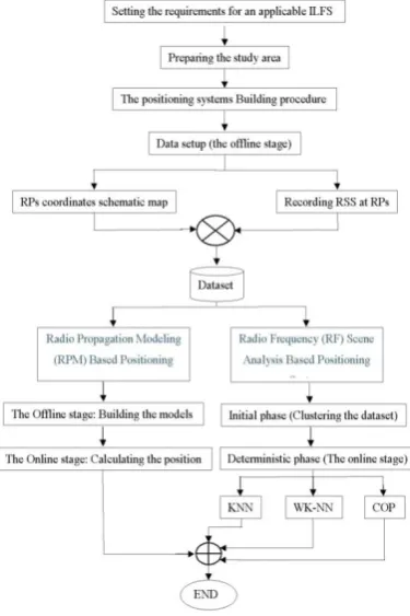
The following flowchart in Figure (3) illustrates the main steps in the proposed approach.
The requirements that have been set to determine whether the designed system is considered an applicable ILFS or not are chosen based on the structure of the environment that the systems are installed in and on the resources needed for the device to calculate the location.
Fig (3) (ILFS) proposed flowchart
The main requirements are:
A) Accuracy: the system must be able to locate the target with an accuracy of 3m or less.
B) Consistency: in this requirement, two goals must be achieved;
First: the system must locate the target within utmost 4m at 0.9 CDF.
Second: the system must achieve at least 0.35 PDF at 1m error distance or less.
C) Scalability: the system must consider locating the target in parts of the environment that are far from the APs without exceeding the threshold level which is set by the following relationship:
Threshold level= (Mean + Standard Deviation) of the error distance.
This requirement will be evaluated on three levels:
[image:2.595.336.524.217.499.2] Medium: This level means that the system's threshold will not exceed more than 50% of the times of measurements when the system is tested at a distance of 75% of the largest dimension in the study area.
Low: this level means that system’s error distance will exceed the threshold level more than 50% of the times when the system is tested at distance of 75% of the largest dimension in the study area.
D) Complexity: the system must consider the hardware and software constrain of the communication network that the system is based on. This requirement will be evaluated on two levels:
High: in this level, the system needs to store large datasets in order to calculate the location.
Low: in this level the system requirement for storing is minimum.
E) Robustness: the system must remain operational in severe conditions of multipath fading and low RSS without causing the system's performance to pass the threshold level (set in the scalability requirement) due to low RSS resolution. This requirement will be evaluated on three levels:
High: in this level, the system's performance will not exceed the threshold level.
Moderate: the system’s performance must not exceed the threshold level more than 10% of the times of measurements.
Low: the system’s performance passes the threshold level more 10% of the times of measurements.
4.
RESEARCH STUDY AREA AND
DATA SETS
All steps beginning from the preparing the study area to the end of the offline stage ware illustrated in [ 11].
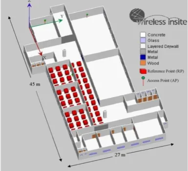
The study area of the research was chosen on the first floor of the building of communication engineering within the campus of the University of Mosul [11] as shown in Figure(4)
Fig 4: Structure of the study area
5.
PRACTICAL RESULTS
The two proposed systems (Radio Propagation Modeling (RPM) Based Positioning) and (Radio Frequency (RF) Scene Analysis Based Positioning System ) were tested over a Samsung GalaxyA5 mobile with 4 cores ARMv7 processor, 1407 MB RAM and 6.0.1 Android operating system, by using Matlab over the mobile application.
[image:3.595.314.540.172.717.2]The results were displayed in terms of the CPU usage caused by running the Matlab process along with the total CPU usage of the processor and used RAM space by the Matlab process.
Fig 5: K-NN CPU usage
[image:3.595.70.263.551.726.2]Fig 6: K-NN RAM usage
Fig 8: WK-NN RAM usage
The Figures 5 to 9 show the used resources of the mobile device when executing the three procedures of the RF scene analysis system. It is clear that the CPU usage of all the three procedures was within an acceptable level and that the CPU was not overwhelmed by heavy calculations; also the amount of RAM needed was trivia
l
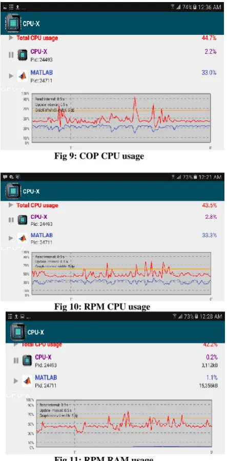
Fig 9: COP CPU usage
[image:4.595.55.277.299.749.2]Fig 10: RPM CPU usage
Fig 11: RPM RAM usage
Figure 10 shows the CPU usage of the mobile device when executing the RPM system, it is evident that the CPU was able to perform the calculation of position without being overwhelmed. Figure 11 shows the RAM usage of the device during the execution of the RPM system and the amount of RAM needed was insignificant.
6.
APPROACH ASSESSMENT AND
RESULTS
When analyzing the results obtained from the performance of the two systems Accuracy, Consistency, Scalability, Robustness and Complexity requirements must be fulfilled. In this paper, Radio Propagation Modeling (RPM) Based Positioning System also implemented and tested.
[image:4.595.310.547.341.568.2]Comparing to the results in [11] the RPM has low complexity requirement regarding other methods in spite of the degradation of other metrics as shown in the table (1). As shown, the requirement Resources can be fulfilled ware only 1.2 % of the total memory ware used, and around 33% of the CPU utilization is required, and these resources can be easily achieved, keeping on mind that these processes are not always running.
Table 1: Performance of the Designed Systems and CPU Utilization
K-NN WK-NN COP RPM1 RPM2
Accuracy 2.870
m 2.719 m
2.870
m 9.862m 9.014
m
CDF 85% 89% 85% 30% 34%
PDF/Distance 0.361/
0.65m
0.394/ 0.63m
0.34/ 0.8m
0.06/ 1m
0.08/ 1m
Scalability Mod Mod Mod Low Low
Complexity High High High Low Low
Robustness Low Moderate Low Low Low
CPU Usage
Approx.
32.1% 25% 33% 33.1% 33.1%
RAM. Usage
1.2%
1.2%
1.2%
1.1%
1.1%
7.
CONCLUSION
The results obtained from this paper show that deploying online stage of the ILFS on Smartphone platforms does not affect its performance. Table 1 shows that the K-NN, WK-NN, COP, and RPM easily implement in the mobile platform without any significant degradation of the performance of the mobile. Around 33% of the CPU usage and only 1.2 % of RAM usage can be considered acceptable. As a future work, some tasks of the offline stage can be swapped to the Smartphone platform where a lot of memory and CPU resources still available.
8.
REFERENCES
[2] D. Quercia, N. Lathia, F. Calabrese, G. D. Lorenzo, and J. Crowcroft, “Recommending social events from mobile phone location data,” Data Mining, IEEE International Conference on, vol. 0, pp. 971-976, 2010.
[3] David M. Rodríguez, Frantz Bouchereau, César V. Rosales, Rogerio E. Caldera, “position location techniques and applications”, Publisher: Elsevier Inc. , 2009, ISBN: 13-978-0-12-374353-4.
[4] Y.-C. Chen, J.-R. Chiang, H.-H. Chu, P. Huang, A.W. Tsui, Sensor-assisted Wi-Fi indoor location system for adapting to environmental dynamics, in: Proceedings of the ACM/IEEE MSWiM 2005, October 2005.
[5] Yih-Shyh Chiou, Chin-Liang Wang, Sheng-Cheng Yeh, Ming-Yang Su, Design of an adaptive positioning system based on WiFi radio signals, Elsevier, Computer Communications 32 (2009) 1245–1254.
[6] Hui Liu, Houshang Darabi, Pat Banerjee, Jing Liu, “Survey of Wireless Indoor Positioning Techniques and Systems”, IEEE Transactions On Systems, Man, And Cybernetics Part C: Applications And Reviews, Vol. 37, NO. 6, November 2007.
[7] Thomas Fagerland Wiig, “Assessment of Indoor Positioning System (IPS) technology”, Master thesis, University of Oslo, Department of Informatics May 3, 2010.
[8] R. Battiti, T. L. Nhat, and A.Villani, "Location-aware computing: A neural network model for determining location in wireless LANs," Tech. Rep. DIT-02–0083, 2002.
[9] P. Bahl and V. N. Padmanabhan, “RADAR: An in-building RF-based user location and tracking system,” in Proc. IEEE. INFOCOM 2000, Mar., vol. 2, pp. 775–784.
[10] Glyn Holland Dr Peter Harrop and Raghu Das. "Real Time Locating Systems 2009-2019", 2009. http://www.idtechex.com/research/reports/real_time_loca ting_systems_2009_2019_000143.asp (28.04.2009).