JOURNAL OF FOREST SCIENCE, 51, 2005 (1): 37–46
The runoff of precipitation water from forested catchment areas is artificially affected by a forest road network. Currently, forest roads are a neces-sary condition for intensive forest management and forest protection. Running off precipitation water causes damage to these forest roads by its erosion. Damage differs according to the technological con-struction of forest roads of particular classes and according to their gradient.
Forest transportation network
The forest transportation network consists of an organised system of adjoining forest roads. Their technological construction substantially differs ac-cording to the transportation function they have in the transportation flow of hauling of extracted tim-ber from the place of logging usually to an adjoining road of the public transportation network.
In accordance with valid standard ČSN 736108
Forest Transportation Network forest roads are categorised according to their transportation func-tion into classes that set down their technological construction and facilities:
– class 1 are forest roads for timber hauling on which the traffic of conveyances is possible all the year round, i.e. currently trucks of higher carrying capacity,
– class 2 are forest loads on which the traffic of the same conveyances is possible at least in the period of the sufficient bearing capacity of subsoil, – class 3 are forest roads used for skidding to hauling
roads, i.e. dragging of semi-suspended logs behind the tractor,
– class 4 are skidding trails used for timber extrac-tion from forest stand to road.
Influence of forest transportation network on runoff conditions
Any technological intervention in the terrain largely influences the runoff of precipitation water. Forest roads cut across the course of unsoaked pre-cipitation water flowing along the gradient in the forest stand. This water is accumulated in ditches of hauling roads and flows through them to culverts from which it flows out into adjoining terrain depres-sions. In skidding roads that do not have any ditches
Forest road erosion
J. DOBIÁŠ
Faculty of Forestry and Environment, Czech University of Agriculture in Prague,
Prague, Czech Republic
ABSTRACT: The forest road network influences surface runoff of uninfiltrated precipitation water on forest lands, mainly in hilly and mountainous areas. This water flows onto the road crown in unpaved forest roads that do not have any ditches. Dragging of extracted logs causes mechanical damage to the crown of unpaved forest road, and tracks after tractor wheels and furrows after dragged logs originate. Flowing water is accumulated in these depressions and the water stream causes erosion. The method for evaluation of conditions for the origination and degree of this ero-sion damage consists in the calculation of tangential stresses near the bottom at various depths of water and various gradients of road. Limit gradients of road for the origination of greater or smaller damage by erosion for the subsoil grain of various sizes are determined by a comparison of calculated tangential stresses with critical tangential stresses. Rates of discharge were calculated for the particular models of damage.
water flows along their crown in the direction of the gradient. So the forest transportation network markedly influences the runoff of precipitation water in uplands and mountains, and in general it diverts its surface runoffs to locally accumulated runoffs of various size. The accumulation of flowing water into streams of various size increases the tangential stress at the bottom causing damage by erosion anywhere the subsoil cohesion and strength are not high enough. Water is accumulated into depressions that originated by skidding on unpaved forest roads in the form of tracks after the wheel traffic of trac-tors and furrows after dragged logs. In wet condi-tions unpaved forest roads suffer damage as soon as a heavy-duty machine goes on such a road several times (e.g. GROSS 1984).
A problem of calculation of the conditions of erosion origination on forest roads
For an exact assessment of erosion origination on forest roads it is necessary to calculate tangential stress. The calculation involves many theoretical and practical problems.
Theoretically, it is possible to obtain only an ap-proximate solution. The applied formulas are derived for the laminar flow of water in channels of constant shape. But the accumulated stream of precipitation water on a forest road does not flow in a channel of regular shape. Precipitation water on the road crown is accumulated into local depressions made by traf-fic, such as wheel tracks and furrows after dragged logs. The shape of these depressions may change after further traffic. The water flow may become turbulent in depressions of generally small depth and irregular shape.
Road ditches are the conditions corresponding to the applied formulas for precipitation water runoff. This problem was solved previously (DOBIÁŠ 1980);
in this paper I will solve the problem of erosion dam-age to the crown of unpaved forest road.
METHOD OF SOLUTION
As a theoretical model I choose the shape of de-pression that is usual on unpaved forest roads: – wheel tracks,
– furrows made by dragged logs.
The following values of water depth in these de-pressions will be used: 0.03, 0.05 and 0.10 m. Tan-gential stress will be calculated for gradients of the road crown from 3% to 15%.
To assess the risk of damage caused by erosion the calculated tangential stress of flowing water at the bottom will be compared for these model cases with the tangential stress critical for the particular subsoil textures of various grain size.
(Du Boys) formula to calculate tangential stress: τ = p × g × R × I
where: τ – tangential stress (Pa),
p – volume weight of water (kg/m3),
g – gravity acceleration (m/s2),
R – hydraulic radius,
I – bottom gradient.
As it is not possible to determine the exact quan-tity of transported bed load in the considered time of calculation and to ensure comparability of the calculated values of tangential stress, the value of volume weight of water equal 1,000 kg/m3 will be used in subsequent calculations.
Wheel tracks
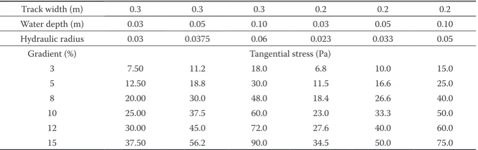
[image:2.595.64.532.608.755.2]For this model example I will use a tractor-wheel track of rectangular shape 0.3 and 0.2 m in width, with water depths 0.03 m, 0.05 m and 0.10 m and road crown gradients 3%, 5%, 8%, 10%, 12% and 15%.
Table 1. Tangential stress in wheel tracks
Track width (m) 0.3 0.3 0.3 0.2 0.2 0.2
Water depth (m) 0.03 0.05 0.10 0.03 0.05 0.10
Hydraulic radius 0.03 0.0375 0.06 0.023 0.033 0.05
Gradient (%) Tangential stress (Pa)
3 7.50 11.2 18.0 6.8 10.0 15.0
5 12.50 18.8 30.0 11.5 16.6 25.0
8 20.00 30.0 48.0 18.4 26.6 40.0
10 25.00 37.5 60.0 23.0 33.3 50.0
12 30.00 45.0 72.0 27.6 40.0 60.0
Table 1 shows the calculated values of tangential stress.
Furrows made by dragged logs
In this model solution it is difficult to determine the log diameter at the place where it makes the
fur-row. It is to note that logs of various diameters and lengths are dragged. For comparison logs 0.20 m and 0.13 m in diameter were taken while water depths and road crown gradients were identical to those in the model of wheel tracks, i.e. water depth 0.03 m, 0.05 m and 0.10 m and gradients 3%, 5%, 8%, 10%, 12% and 15%.
Unlike the simple rectangular profile of wheel tracks it is more complicated to calculate the hy-draulic radius for this model. The area of discharge profile for log diameter 0.20 m can be calculated for all considered depths as a segment of circle from the formula
F = 0.5 × r2 ((π φ)/180 – sin φ)
where: r – log diameter at the place of contact (m), φ – central angle in degrees corresponding to the
water surface.
[image:3.595.65.532.72.218.2]Wetted perimeter is calculated from the equa-tion:
Table 2. Tangential stress in furrows made by dragged logs
Log diameter (m) 0.20 0.20 0.20 0.13 0.13 0.13
Water depth (m) 0.03 0.05 0.10 0.03 0.05 0.01
Hydraulic radius 0.02 0.02930 0.05000 0.01704 0.02860 0.04060
Gradient (%) Tangential stress (Pa)
3 5.30 8.8 15.0 5.1 8.5 12.2
5 8.90 14.7 25.0 8.5 14.1 20.3
8 14.20 23.5 40.3 13.6 22.6 32.5
10 17.70 29.3 50.0 17.0 28.3 40.6
12 21.20 35.2 60.0 20.4 33.9 48.7
[image:3.595.65.291.252.392.2]15 26.60 44.0 75.0 25.6 42.2 60.9
Table 3. Whole crown of the road
Road width (m) 3.00 3.00
Water depth (m) 0.03 0.05
Hydraulic radius 0.03 0.048
Gradient (%) Tangential stress (Pa)
5 14.50 24.0
8 23.20 38.4
10 29.00 48.0
12 34.80 57.6
[image:3.595.65.532.523.757.2]15 43.50 72.0
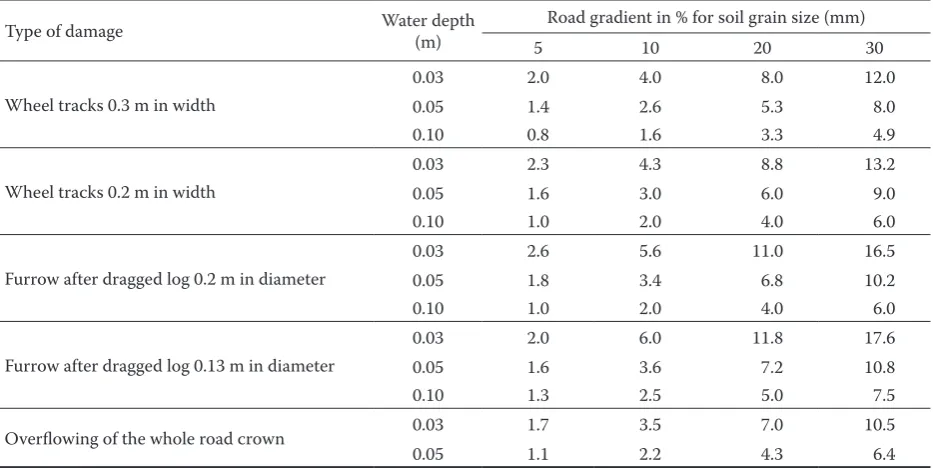
Table 4. Road gradient at critical tangential stress
Type of damage Water depth (m) Road gradient in % for soil grain size (mm)
5 10 20 30
Wheel tracks 0.3 m in width
0.03 2.0 4.0 8.0 12.0
0.05 1.4 2.6 5.3 8.0
0.10 0.8 1.6 3.3 4.9
Wheel tracks 0.2 m in width
0.03 2.3 4.3 8.8 13.2
0.05 1.6 3.0 6.0 9.0
0.10 1.0 2.0 4.0 6.0
Furrow after dragged log 0.2 m in diameter
0.03 2.6 5.6 11.0 16.5
0.05 1.8 3.4 6.8 10.2
0.10 1.0 2.0 4.0 6.0
Furrow after dragged log 0.13 m in diameter
0.03 2.0 6.0 11.8 17.6
0.05 1.6 3.6 7.2 10.8
0.10 1.3 2.5 5.0 7.5
Overflowing of the whole road crown 0.03 1.7 3.5 7.0 10.5
O = (π × r × φ)/180
For logs 0.13 m in diameter this method of calcula-tion can be used only to a water depth of 0.065 m. For larger depths the area of discharge profile should be calculated as the sum of the semi-circle and the adjoining rectangle.
Table 2 shows the calculated values of tangential stress.
Whole crown of the road
For comparison I will present the values of tan-gential stress at the bottom that would occur if the accumulated precipitation water flew along the whole crown of unpaved forest road, for depths of 0.03 and 0.05 m and for analogical gradients as used in previous models (TUHÁČEK2002). In prac-tical conditions it could happen only exceptionally because the depressions into which water is ac-cumulated are usually larger than the considered water depth.
Table 3 shows the calculated values of tangential stress.
DISCUSSION
The calculations of tangential stress of accumu-lated precipitation water flowing along the crown of unpaved forest road are biased by inaccuracies because the formulas for waterflow in channels were used as it was explained above. But a possibility of comparing the particular model cases was respected. They were chosen in order to document the cases
of erosion damage usually occurring on unpaved forest roads.
The risk of damage caused by erosion will be as-sessed by comparing tangential stresses calculated for the given models of damage to the crown of unpaved forest roads with critical tangential stresses when the soil grains of various size start moving (KOVÁŘ 2002). Kovář’s values are given in Table 4.
Conditions for origination of damage caused by erosion
The erosive effect of flowing water on the crown of unpaved forest road, expressed by the calculated tangential stress, is a manifestation of the kinetic energy of flowing water. Regardless of the order, it is mainly influenced by
– the gradient of forest road crown,
– the rate of discharge, given by the size of discharge profile.
The erosive effect of water on the soil is not identi-cal under the identiidenti-cal tangential stress. It depends on its cohesion given by its texture. So different dam-age may be caused on similar forest roads in various areas of the Czech Republic.
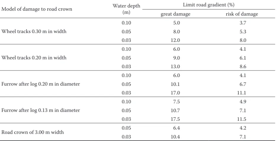
[image:4.595.65.539.516.755.2]For our models of damage to the crown of unpaved forest roads, i.e. wheel tracks and furrows after log dragging, such a state will be taken as a probability of the origination of damage caused by erosion when the calculated tangential stress at the bot-tom of accumulated flowing water (Tables 1 and 2) is higher than the critical tangential stress under the same conditions (Table 4). For comparison
Table 5. Limit road gradients at the beginning of damage by erosion
Model of damage to road crown Water depth (m) Limit road gradient (%)
great damage risk of damage
Wheel tracks 0.30 m in width
0.10 5.0 3.7
0.05 8.0 5.3
0.03 12.0 8.0
Wheel tracks 0.20 m in width
0.10 6.0 4.1
0.05 9.0 6.1
0.03 13.0 8.6
Furrow after log 0.20 m in diameter
0.10 6.0 4.1
0.05 10.1 6.7
0.03 17.0 11.1
Furrow after log 0.13 m in diameter
0.10 7.5 4.9
0.05 10.7 7.1
0.03 17.5 11.5
Road crown of 3.00 m width 0.05 6.4 4.2
I will also consider a theoretical example when water flew along the whole crown of unpaved forest road without ditches (Table 3).
This comparison shows that the origination of damage caused by erosion in tracks and furrows is probable from the road gradient 3% if the subsoil grain size is 5 mm. Drawing this general conclusion it is not possible to take into account the fact that the cohesion of soils reflected in their bearing capacity decreases with increasing soil moisture content. The grain size of the soil 5 mm is small, but if it were washed out, the natural structure of the soil would be disturbed and damage caused by the mechanical action of wheels and dragged logs would increase.
If we take the potential movement of soil grains 20 to 30 mm in diameter as a criterion, the probability of the origination of damage by erosion can be divided into 3 groups:
– great erosion damage at the movement of soil grains 30 mm in diameter,
– risk of erosion damage of a larger extent at the movement of soil grains 20 mm in diameter, – erosion damage of a smaller extent.
[image:5.595.66.531.75.296.2]In real conditions, the soil on the crown of for-est roads is composed of a mix of grains of various diameters. The limit values for theoretical calcula-tions were chosen in a speculative way: 30 mm is the smallest depth of model damage to the road crown Table 6. Wheel tracks
Width 0.3 m
Depth 0.03 m Rate (m/s)
Area 0.009 m2 Discharge Q
(m3/s)
Depth 0.05 m Rate (m/s)
Area 0.015 m2 Discharge Q
(m3/s)
Depth 0.1 m Rate (m/s)
Area 0.03 m2 Discharge Q
(m3/s) Gradient (%)
3 2.3777 0.0214 2.8769 0.0432 3.5881 0.1076
5 2.5546 0.0230 3.0909 0.0464 3.8550 0.1156
8 2.7271 0.0245 3.2996 0.0495 4.1153 0.1235
10 2.8127 0.0253 3.4032 0.0510 4.2445 0.1273
12 2.8846 0.0260 3.4902 0.0524 4.3530 0.1306
15 2.9747 0.0268 3.5993 0.0540 4.4890 0.1347
Width 0.2 m
3 2.2867 0.0137 2.7095 0.0271 3.2939 0.0659
5 2.4559 0.0147 2.9101 0.0291 3.5377 0.0708
8 2.6222 0.0157 3.1072 0.0311 3.7773 0.0755
10 2.7048 0.0162 3.2050 0.0320 3.8962 0.0779
12 2.7739 0.0166 3.2868 0.0329 3.9957 0.0799
15 2.8603 0.0172 3.3892 0.0339 4.1202 0.0824
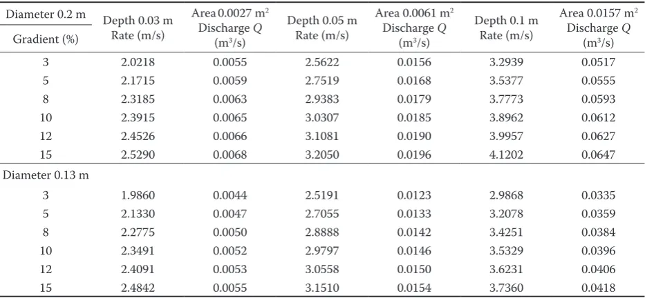
Table 7. Furrows after dragged logs
Diameter 0.2 m Depth 0.03 m Rate (m/s)
Area0.0027 m2 Discharge Q
(m3/s)
Depth 0.05 m Rate (m/s)
Area 0.0061 m2 Discharge Q
(m3/s)
Depth 0.1 m Rate (m/s)
Area 0.0157 m2 Discharge Q
(m3/s) Gradient (%)
3 2.0218 0.0055 2.5622 0.0156 3.2939 0.0517
5 2.1715 0.0059 2.7519 0.0168 3.5377 0.0555
8 2.3185 0.0063 2.9383 0.0179 3.7773 0.0593
10 2.3915 0.0065 3.0307 0.0185 3.8962 0.0612
12 2.4526 0.0066 3.1081 0.0190 3.9957 0.0627
15 2.5290 0.0068 3.2050 0.0196 4.1202 0.0647
Diameter 0.13 m
3 1.9860 0.0044 2.5191 0.0123 2.9868 0.0335
5 2.1330 0.0047 2.7055 0.0133 3.2078 0.0359
8 2.2775 0.0050 2.8888 0.0142 3.4251 0.0384
10 2.3491 0.0052 2.9797 0.0146 3.5329 0.0396
12 2.4091 0.0053 3.0558 0.0150 3.6231 0.0406
[image:5.595.64.531.541.757.2]and at the same time approximately the smallest diameter of grains of broken stone used for the construction of forest road surfaces.
In any case, tangential stress increases with in-creasing road gradient. Table 5 shows the limit gra-dients of unpaved forest road when erosion damage of these groups may occur in model cases.
Rates of discharge
Damage caused by erosion in the assumed model cases may occur only if the rate of discharge is
per-manently as high as it is necessary to ensure the assumed water depth. It will depend on the cross-section of water flow in a model example and on the road gradient. As the values of the assumed road gradients are quite high, I will use Ehrenberger’s formula for the calculation of the mean rate of water flow (MAKOVNÍK et al. 1973). The formula for the assumed gradients is
vE = v × k = 55 R0.52 sin α0.40 × 0.40 R–0.05 sin α –0.26 and after adjustment
[image:6.595.66.534.74.182.2]vE = 22 R0.47 sin α0.14 Table 8. Whole road crown
Width 3.0 m Depth 0.03 m
Rate (m/s) Area 0.09 m 2
Discharge Q (m3/s) Depth 0.05 m Rate (m/s) Area 0.15 m 2 Discharge Q (m3/s) Gradient (%)
3 2.5908 0.2332 3.2939 0.4941
5 2.7826 0.2504 3.5377 0.5307
8 2.9710 0.2674 3.7773 0.5666
10 3.0646 0.2758 3.8962 0.5844
12 3.1428 0.2829 3.9957 0.5994
[image:6.595.63.530.210.342.2]15 3.2408 0.2917 4.1202 0.6180
Table 9. Increase in the flow rate and in the rate of discharge at an increase in the gradient
Gradient (%) Increase/base 3% Difference (%) Interval Increase to 1% of gradient
1 85.63% 1
2 94.55% 8.92 1 8.92%
3 100.00% 5.45 1 5.45%
5 107.40% 7.44 2 3.72%
8 114.68% 7.25 3 2.42%
10 118.28% 3.61 2 1.80%
12 121.31% 3.03 2 1.52%
15 125.09% 3.78 3 1.26%
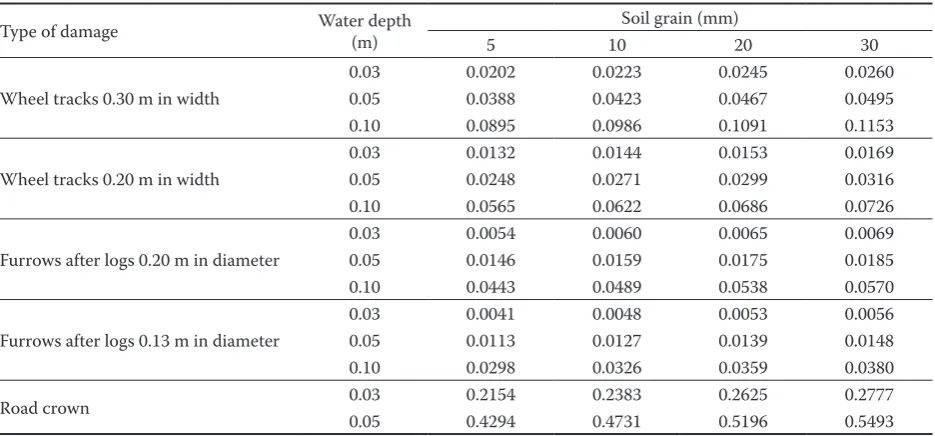
Table 10. Rates of discharges at critical tangential stresses (m3/s)
Type of damage Water depth (m) Soil grain (mm)
5 10 20 30
Wheel tracks 0.30 m in width
0.03 0.0202 0.0223 0.0245 0.0260
0.05 0.0388 0.0423 0.0467 0.0495
0.10 0.0895 0.0986 0.1091 0.1153
Wheel tracks 0.20 m in width
0.03 0.0132 0.0144 0.0153 0.0169
0.05 0.0248 0.0271 0.0299 0.0316
0.10 0.0565 0.0622 0.0686 0.0726
Furrows after logs 0.20 m in diameter
0.03 0.0054 0.0060 0.0065 0.0069
0.05 0.0146 0.0159 0.0175 0.0185
0.10 0.0443 0.0489 0.0538 0.0570
Furrows after logs 0.13 m in diameter
0.03 0.0041 0.0048 0.0053 0.0056
0.05 0.0113 0.0127 0.0139 0.0148
0.10 0.0298 0.0326 0.0359 0.0380
Road crown 0.03 0.2154 0.2383 0.2625 0.2777
[image:6.595.64.532.538.756.2]where: vE – mean profile rate (m/s),
k – aeration coefficient,
R – hydraulic radius (m),
α – angle of road gradient in degrees.
Tangential stresses and erosive processes in the above-mentioned model examples of road damage would be evoked by the rates of discharge that would equal the product of the mean profile rate and the cross-section area of the given road damage. These discharges are also limiting factors for the assumed models of damage by erosion to forest roads. Tables 6–8 show their values for the above-mentioned models of forest road damage.
The results show changes in the rate of discharge in relation to the cross-section area of the given model of road damage and to the change in water flow rate. This discharge increases directly proportionately to an increase in the cross-section of the given model of deformation and to an increase in the flow rate. The increase in the flow rate is influenced by an in-crease in the road gradient and by an inin-crease in the cross-section area of water flow that is determined by the hydraulic radius. At a constant cross-section the change depends on the road gradient according to the relation
v = k × sin α0.14
where the constant k indicates the influenceofthecross-section of the model of deformation by the relation
k = 22 R0.47
The letters indicate the same variables as in Ehren-berger’s formula.
Table 9 shows the numerical expression of an increase in the flow rate in relation to the road gra-dient.
The erosive effects of water start when the tan-gential stress at the bottom of water flow is higher than the tangential stress critical for the diameter of the bottom soil grain. Table 10 shows the rates of discharges calculated for the assumed model examples of road damage and soil grain diameters 5–30 mm.
The results of these theoretical calculations show that the risk of erosion arises when the extent of damage to the road crown is small and the rates of discharge are also relatively low. With the increas-ing cross-section of model damage to the road crown the necessary rate of discharge increases and the surface and volume extent of damage is also greater.
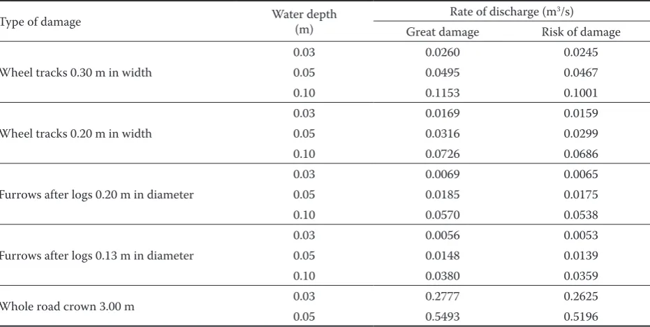
[image:7.595.65.531.73.307.2]To calculate the rate of discharge when the risk of damage caused by erosion arises for the assumed models of damage to the road crown is feasible only if the diameter of the bottom soil grain can be determined. But it is problematic because the forest road crown always consists of sets of soil grains of various diameters, the composition of which changes locally. To solve this problem at least preliminarily, this diameter of soil grains must be determined in a speculative way. For a preliminary determination of the rate of discharge in the assumed model damage to the crown road that will cause marked damage by erosion I chose the soil grain diameter 30 mm, which corresponds to the lower limit of the grain size of broken stone. Table 11. Rate of discharge at the limit gradients for the beginning of erosion
Type of damage Water depth (m) Rate of discharge (m3/s)
Great damage Risk of damage
Wheel tracks 0.30 m in width
0.03 0.0260 0.0245
0.05 0.0495 0.0467
0.10 0.1153 0.1001
Wheel tracks 0.20 m in width
0.03 0.0169 0.0159
0.05 0.0316 0.0299
0.10 0.0726 0.0686
Furrows after logs 0.20 m in diameter
0.03 0.0069 0.0065
0.05 0.0185 0.0175
0.10 0.0570 0.0538
Furrows after logs 0.13 m in diameter
0.03 0.0056 0.0053
0.05 0.0148 0.0139
0.10 0.0380 0.0359
Whole road crown 3.00 m 0.03 0.2777 0.2625
I consider the disturbance of stability of the bot-tom consisting of the soil grain 20 mm in diameter as the beginning of the risk of damage caused by erosion. Table 11 shows the numerical results of these calculations.
These preliminary calculations indicate that the risk of damage caused by erosion to forest roads may arise at relatively small disturbances of the road crown and at corresponding low rates of dis-charge.
CONCLUSION
Unpaved forest roads are damaged by erosion caused by accumulated precipitation waters that flow along their crown. This water is accumulated into depressions on the crown caused by traffic, particularly by skidding of extracted semi-suspended logs dragged behind the tractor. In general, damage caused by erosion increases with the increasing gradient of forest road and with the increasing rate of discharge. In otherwise identical conditions the extent of such damage is influenced by the texture of the subsoil.
The probability of the origination of damage caused by erosion to unpaved forest roads can be assessed theoretically by comparing tangential stress at the bottom of flowing water with critical tangential stress corresponding to the texture of subsoil. These relations were theoretically examined on models of damage to the forest road crown that arises during skidding on unpaved forest roads. It is tracks of tractor wheels and furrows after dragged logs. For comparison these relations were theoreti-cally assessed on a model of the overflowed whole crown of forest road. For all assumed models the respective rates of discharge were calculated that are a necessary condition for damage by erosion for the assumed model case of damage to the forest road crown.
An important task from the aspect of the stability of forest road network and its permanently good function is to prevent such damage or to reduce its extent. Both projecting and technical measures can be used to solve this problem.
If a forest road network is projected, the whole forest area should be made accessible in a purpose-ful way. But in the mountains and uplands it is not possible to project skidding unpaved forest roads with such a small gradient that would avoid damage by erosion. To minimise erosion these roads should be laid out with the smallest possible and constant gradient, copying the terrain. It will eliminate local
segments of the road alignment with large gradients that are mainly damaged by erosion.
Technical measures should reduce damage to the crown of unpaved forest road during skidding and prevent the accumulation of precipitation water on the road crown.
It is not possible to prevent damage to unpaved forest roads during skidding of extracted logs, but damage will be substantially smaller if skidding is carried out on dry roads or when it freezes and snow covers the road. Systematic and timely maintenance will prevent the deepening of wheel tracks and fur-rows after dragged logs and a simultaneous increase in tangential stress at the bottom of flowing accumu-lated precipitation water that causes erosion.
Various technical measures may prevent the ac-cumulation of precipitation water on the road crown and its flowing along the gradient. A ditch on the sloping side of the road will prevent the flowing of precipitation water from the forest stand and will divert it along the road towards the culvert. The cross-fall of the road crown of at least 5% will divert precipitation water into a ditch and will minimise its longitudinal flowing. On the contrary, collect-ing drains that would also prevent this longitudinal flowing of water along the road crown are damaged and choked with soil during log dragging, so they do not perform their function as their cleaning is not usually sufficient.
Damage by erosion to unpaved forest roads may considerably reduce their practicability and reduce their function. Therefore great attention should per-manently be paid to the measures that would prevent such damage.
References
DOBIÁŠ J., 1980. Racionalizace projektování a stavby polních cest s ohledem na protierozní ochranu. [Závěrečná zpráva.] Praha, VŠZ: 96.
GROSS J., 1984. Zhodnocení použitých mechanizačních prostředků v těžebně-dopravním procesu u Severočeských státních lesů. Praha, VŠZ: 127.
KOVÁŘ P., 2002. Hrazení bystřin. Praha, ČZU: 5–9. MAKOVNÍK Š. et al., 1973. Inžinierské stavby lesnícke.
Bra-tislava, Príroda: 709.
TUHÁČEK F., 2002. Lesní cesty a voda. In: Sborník z vědecké konference Krajina, les a vodní hospodářství II. Praha, ČZU: 3.
Nezpevněné lesní cesty jsou poškozovány erozí působenou soustředěnými srážkovými vodami, kte-ré stékají po jejich koruně. Tato voda se soustředí do depresí v koruně způsobovaných provozem – ze-jména přibližováním vytěžených kmenů v polozá-věsu za traktorem. Obecně se škody erozí zvětšují při zvyšujícím se podélném sklonu lesní cesty a při zvyšujícím se průtočném množství vody. Za jinak stejných podmínek je velikost těchto škod ovlivněna zrnitostním složením podložní zeminy.
Pravděpodobnost vzniku škod erozí na nezpevně-ných lesních cestách je možné teoreticky posoudit porovnáním tangenciálního napětí u dna proudící vody s tangenciálním napětím kritickým, odpoví-dajícím zrnitostnímu složení podložní zeminy. Tyto závislosti byly teoreticky sledovány na modelech poškození koruny lesních cest, která vznikají při při- bližování dřeva na nezpevněných lesních cestách. Jsou to koleje vytlačené koly traktorů a rýhy vyryté kmeny vlečených kmenů. Pro srovnání jsou tyto vztahy teoreticky posuzovány na modelu plně zapla-vené celé koruny lesní cesty. Pro všechny uvažované modely jsou zároveň vypočtena příslušná průtočná množství vody, která jsou nezbytným předpokla-dem škod erozí pro uvažovaný modelový případ po-škození koruny lesní cesty.
Zabránění vzniku těchto škod – nebo aspoň sní-žení jejich rozsahu – je důležitý úkol pro stabilitu lesní dopravní sítě a její trvale dobrou funkci. K je-ho řešení je možné použít jak opatření projekční, tak technická.
Při projektu lesní dopravní sítě je nutné účelně zpřístupnit celou plochu lesa. V horách a pahorkati-nách nelze navrhovat nezpevněné přibližovací lesní cesty v tak malém podélném sklonu, aby nemohly být poškozovány erozí. Pro její minimalizaci je však třeba tyto cesty trasovat v co nejmenším a konstant-ním sklonu, přimknuté k terénu. Tím se alespoň vyloučí místní úseky trasy s velkým sklonem, které jsou erozí zvlášť poškozovány.
Technická opatření musejí omezovat poškozová-ní koruny nezpevněné lespoškozová-ní cesty při přibližovápoškozová-ní dřeva a zabraňovat soustřeďování srážkové vody na koruně cesty.
Poškozování nezpevněné lesní cesty při přibližo-vání vytěžených kmenů nelze zabránit, poškození se však podstatně zmenší, bude-li se přibližovat za su-cha nebo za mrazu a na sněhu. Systematická a včas-ná údržba pak zabrání prohlubování vyjetých kolejí a rýh od vlečených kmenů a tím zvyšování tangen-ciálního napětí u dna proudící soustředěné srážkové vody, které působí erozi.
Zabránit soustřeďování srážkové vody na koruně cesty a jejímu stékání v podélném sklonu je možné různými technickými opatřeními. Příkop na svahové straně cesty zabrání stékání srážkové vody z poros-tu na cesporos-tu a svádí ji podél cesty k propustku. Příčný sklon koruny cesty (alespoň 5%) svede srážkovou vodu do příkopu a minimalizuje tak její podélné proudění. Naproti tomu svodnice, které by rovněž zabraňovaly tomuto podélnému proudění vody po koruně cesty, jsou poškozovány a zanášeny zeminou
Eroze na lesních cestách
J. DOBIÁŠ
Fakulta lesnická a environmentální, Česká zemědělská univerzita v Praze, Praha, Česká republika
ABSTRAKT: Lesní dopravní síť ovlivňuje povrchový odtok nevsáklých srážkových vod na lesní půdě, zejména v pahor-katinách a na horách. U nezpevněných lesních cest, které nemají příkopy, stéká tato voda na korunu cesty. Vlečením vytěžených kmenů je koruna nezpevněné lesní cesty mechanicky poškozována a vytvářejí se vyjeté koleje od kol traktorů a rýhy od vlečených kmenů. Do těchto depresí se stékající voda soustřeďuje a vytváří vodní proud působící erozi. Metodikou posouzení podmínek pro vznik a velikost těchto škod erozí je výpočet tangenciálních napětí vznikajících u dna při různých hloubkách vody a různých podélných sklonech cesty. Mezní podélné sklony cesty pro vznik větších nebo menších škod erozí pro různé velikosti zrna podložní zeminy jsou zjištěny porovnáním vypočtených tangenciálních napětí vodního proudu u dna s tangenciálními napětími kritickými. Dále jsou vypočtena průtočná množství vody pro jednotlivé modely škod.
Corresponding author:
Doc. Ing. JIŘÍ DOBIÁŠ, CSc., Česká zemědělská univerzita v Praze, Fakulta lesnická a environmentální, 165 21 Praha 6-Suchdol, Česká republika
tel.: + 420 228 382 652, fax: + 420 224 382 658, e-mail: dobias@fle.czu.cz
při vlečení kmenů; tak při obvykle nedostatečném čištění neplní svou funkci.
Škody erozí na nezpevněných lesních cestách mo-hou značně omezit jejich sjízdnost a tím omezit