Heterogeneous Spatial Data Integration Process
Using Business Intelligence Approach
M. Mustafa, A. Aliff , M. Yazid
Department of Computer Science, Faculty of Science & Technology Universiti Malaysia Terengganu
Kuala Terengganu, Malaysia
Abstract— The issues with heterogeneous sources of business
documents containing unstructured data such as e-mail, maps, reports, images, movies, spreadsheets, web contents, presentation, etc. show that it is unclear to identify which information belongs in the metadata and which to the data. The current spatial data integration techniques are generally by creating metadata and spatial data independently and storing them in separate databases. By adapting Business Intelligence approach in the integration process, given us the best decision supporting tools for the organisation to manage any decision related to the information hat already integrate from multiple sources and format of information in distribute locations.
Keywords— Business Intelligence, metadata, spatial data.
I. INTRODUCTION
Nowadays most of the information in government, industry, business, and other institutions are stored electronically, in the form of text databases. Data stored in most text databases are semi structured data in that they are neither completely unstructured nor completely structured. Consequently, these lead business stakeholders to take major and momentous decisions. Most of such business data were from structured sources and eventually feed to a business database. This scenario is accept in the past due to the limited resources, limited capacity of unstructured data, and lacking proper techniques to manage unstructured data [1]. However, the evolution of unstructured data has dramatically exceeded the amount of structured data. The proportion of unstructured data in the total number of information is much larger that the proportion of structured data. In fact, in the last years there has been a dramatic growth in the volume of unstructured data, due to the increase usage of the internet and the huge number of individuals and organizations which create and store such data. According to [2], 80 percent of a company's knowledge is unstructured. 85 percent of business is conduct on unstructured data. Moreover, 80 percent of unstructured text is part of any structured document. Therefore this information cannot be used in the text body of that document.
The integration of unstructured data is regarded to be of high value for business as approximately 80 per-cent of information resides in this format. Therefore, this paper propose and discuss an integrate model that binds respective state of the art approaches together, and thereby provides a structure for Business Intelligence infrastructures that enables holistic decision support. In this regard, this
paper give attention to: i) Metadata creation management as the primary way for extracting metadata from unstructured data; and ii) Spatial-metadata integration that enables the spatial data to carry their own metadata description with them. Finally, the design of Spatial-metadata management system model that distinguished between already existing spatial data models.
II. BACKGROUND
Spatial data are also known as geo-data or geospatial data. This type of data is use in order to gain knowledge of information which have a reference to the location (spatial reference). According to [3], information from the spatial data is one of the essential information in daily life for any type of decision making especially in emergency situations. It can make sound decisions at the local, regional and global levels [4]. For the period of 2004–2010, the overall growth of geospatial industry has increase by 11% in the areas of data, software and services [5]. The result from this report shows that the spatial data is the fastest growing segment of the geospatial industry and is definitely becoming a major contributor to the overall growth of the industry [6]. Due to this situation, the geospatial industry rapidly manages and locates such resources. Consequently, this leads spatial-metadata to plays its role in the management and location of these resources. Reference [7] stated that, in order to manage and locate spatial data resources, metadata is capable to organize, maintain and document the spatial resources internally.
Metadata is a key for transforming unstructured data into a structured environment. Reference [2] defines metadata as "data about data" that may describe an individual datum, or content item, or a collection of data including multiple content items and hierarchical levels.
The metadata about a document is usually shows how the document should be classified. The information contain with unstructured data can be structured if it is describe with metadata. Unfortunately, the most unstructured content does not identify metadata. Therefore, by inserting the metadata description into unstructured environment, unstructured data can be transformed into structured data, and define data semantics [2].
overview of current problems concerning the problem with unstructured data in business environments. The authors estimate that more than 85 percent of all business information exists as unstructured data – commonly appearing in emails, memos, notes from call centres and support operations, news, user groups, chats, reports, letters, surveys, white papers, marketing material, research, presentations and Web pages. As the data is introduce in the Business Intelligence environment, metadata needs to be made available to the Business Intelligence community. Metadata from the business documents provides context to the data and thus it make the meaning of the data explicit and provides definitions of data elements in business terms from the business point of view. Currently, metadata acquisition and management often play a subordinate role in many organizations and are considering overhead [9].
Metadata management is an essential part of the Business Intelligence strategy as it explains how, why, and where the data can be found, retrieved, stored, and used in an information management system. Metadata can get advantage in Business Intelligence. An effective metadata management enables productivity improvements by helping with the data lineage, reduction in data redundancy, knowledge retrieval and transfer of enterprise information, impact analysis, data quality in the enterprise, information sharing, navigation of the corporate data assets, inventory of corporate data assets, and identification of data discrepancies and overlap. Unfortunately, according to [8], the management of business metadata is recognize as one of the major unsolved problems in the business environment, the main reason being that the tools and techniques that have proved so successful transforming structured data into Business Intelligence and actionable information simply don’t work when it comes to unstructured data.
III.DATA INTEGRATION AND STATE-OF-ART BUSINESS
INTELLIGENCE TOOLS
Generally data integration involves some process that combine data from heterogeneous of data sources in order to provide a unify view of data in a structured form [10], [11]. The data integration process is operates by applying a global data model and by detecting and resolving schema and data conflicts so that a homogeneous, unify view can be provided [12]–[14].
From the Business Intelligence perspective, data integration provides useful information to enable better business decisions. The main objective of data integration in the Business Intelligence is to process data from heterogeneous sources, integrate and visualize them in a comprehensive and user friendly way that enhances decision making process. Multiple disparate data sources, data integration services, data management services, reporting, analytical services, information delivery, and consumption services from the broad spectrum of the Business Intelligence architecture.
Recent years, various specific aspects in information integration approaches [15]–[17] have been studied, proposed and suggested in the pursuit of achieving an ideal data integration system by the research community. The finding from reviewing some existing data integration model shows that there is a remarkable history of previous
research projects and study in the area of data integration. Unfortunately most of these integration approaches do not abstract spatial and metadata integration perspectives that involve with management of unstructured data.
Generally data integration in Business Intelligence provides a single view of the truth. The integration architecture is based on the existence of a Data Warehouse on which data from all sources are integrate and from which all views of information are drag. Heterogeneous sources of data are integrated into Data Warehouse using ETL (Extract, Transform, and Load) processes that transform all the data from the Data Warehouse into meaningful information. However, not all data warehouses are used for Business Intelligence, nor do all Business Intelligence applications require a data warehouse.
There has been some recent work on proposing a Business Intelligence framework for managing data integration process. Reference [18] proposes an integrate model that includes two primary as be illustrated in Fig. 1:
Fig. 1: Example of Business Intelligence framework [18]
A. Getting Data In
This process is based on the Data Warehouse approach that involves loading the data from a set of source systems into an integrate data warehouse [18]. The data is being loaded from heterogeneous platforms which may contain different sources, differences location of databases, and differences data format. These data are being integrated and transformed for further data analysis process.
The process of manipulating the data on this stage involves with the group of ETL processes (Extract, Transform, and Load). For loading the data into the Data Warehouse, the process of ETL is taking place on an ODS (Operational Data Store) on which data transformation is taking place before load on Data Warehouse [18]. Moreover, Data Marts mostly will be implemented as a data repository that serves specific users (of the specific department, geographic area, application). All data marts use the same Data Warehouse in order to ensure a “single version of truth” [18].
B. Getting Data Out
Reference [19] proposes an integration model that based on the perspectives of knowledge requires in the Business Intelligence framework. Fig. 2 illustrated the suggested architecture that is based on three relevant layers. This model follows the knowledge retrieval process that produced the information in the analysis and evaluation result, aiming for the business decision management.
Fig. 2: Example of Information Integration framework [19].
The Data Layer is responsible for managing the data from heterogeneous platforms that may contain with structured and unstructured form. For structured data form, this type of data usually be loaded into data repositories such as Data Warehouses, Data Marts, and Operational Data Stores, while for unstructured data form, this type of data is be loaded into Content and Document Management Systems. This system is responsible to handle business metadata contents.
The process of loading the data from heterogeneous source involves some process of data extraction and transformation that includes with some operational systems such as ERP, SCM systems, and external data sources. The Logic Layer provides some schemas that enable the structured data or unstructured content to be analysed. Furthermore, these schemas also support the distribution of relevant knowledge.
The Access Layer provides the user with the capability to use all relevant schemas of the Logic Layer in an integrate fashion. Usually at the Access Layer, all relevant schemas from the logic layer are visualising with some sort of portal software that provide a harmonize Graphical User Interface [19].
IV.PROPOSED THREE LAYERS OF SPATIAL-METADATA
MANAGEMENT SYSTEM
There are many ways to integrate different types of content. One way to classify these frameworks is in terms of three-tier architecture. In this section, this paper proposes the Spatial-metadata Management system which refers the three layer framework proposes by [19]. As illustrated in Fig. 3, these three layers of the Spatial-metadata Management system will be discussed in further detail. For each layer its components and their interactions are described. The differences from the model [19] are at the
components of Data layer. Therefore, special emphasis is given to the components at the Data layer that: i) Manage metadata creation by extracting metadata from unstructured data; and ii) Manage integration process of spatial data and metadata and query process from the middleware system.
Fig. 3: Spatial-metadata Management System for Business Intelligence.
The workflow and components of this system are within the GeoNetwork open-source environment and refer to the three-layer Business Intelligence architecture of Data, Logic, and Access layers that will manage the information retrieval process. The technicians exchange between spatial data and metadata as well as integration of data from heterogeneous sources will be focused during this process. In order to understand the processes in Spatial-metadata Management System better, certain relevant components and their processes have been analysed. This is necessary for the further progress in order to understand how spatial data and metadata can support certain parts of the workflow and existing components.
In order to implement the system, some open source technologies such as GeoNetwork opensource catalogue, degrees Web Map Server Transactional (degree WMS‐T), Catalog Service – Web (CSW) server, PostgreSQL, PostGIS, OpenLayers, and GeoExt are be suggested.
A. Data Layer
The components of the Data layer are responsible to manage the process of reading the properties of a spatial dataset from the dataset and be written into its spatial metadata. This might be analogous to the concept of a Data Warehouse, but extend to unstructured content. The designing proposed model is difference from the traditional Business Intelligence model. The Data layer in the proposed model consist additional layer that acts as a middleware virtual layer. Metadata layer in the proposed model is a layer of structured, semistructured and unstructured data that acts as a central control point for metadata generation [2]. This layer must capable to map the “content sources” to each other. Furthermore, there is a need for other approaches that can deal with spatial data that has no existing metadata associate with it [20], [21].
Therefore, in order to manage unstructured data manipulation process and metadata-based content creation, the next consideration is the implementation of Metadata Creation Management with the special storage repository
Web Map System
Access Layer
Metadata Repositories
Logic Layer
GUI System
Data Layer
Data Sources
DB1
(MYSQL)
DB2
(MS ACCESS)
DB3
(ORACLE)
DBn
(OTHERS) deegree Web Server Middleware System GeoNetwork Server
Middleware
Server
Content Management System
Metadata Layer
for extracting data from unstructured documents [12] and for communicating with all of the different unstructured content sources. During these processes, every collection of unstructured content from heterogeneous sources are being stored and handled in special storage repository –Metadata database. This storage repository of unstructured content can be thought of as a “content warehouse”. Thus, the relevant content from different source applications are normalizes into a cohesive schema and then migrates into this database. The extraction process itself might be included with some sophisticated text mining tools. After its storage, the metadata-based content descriptions can be synchronized with its matching record in the database at the Data layer. Metadata database is not just storing information from heterogeneous sources into a single repository but also migrate the unstructured content into a format that can be easily indexed and queried. To accomplish the process of metadata creation, the Metadata database consists of a series of services: i) An Indexing Engine to allow full text indexing of unstructured content; and ii) A Metadata Extraction Engine to search metadata within the text of unstructured content.
The designing of the proposed model are also difference from the traditional Business Intelligence model. The Data layer in the proposed model does not require Data Repositories such as Data Warehouses, Data Marts, and Operational Data Stores in order to retrieve, integrate, and store information from heterogeneous source. In this layer , two data storage that contain the same set of metadata elements for each metadata record is being implemented: i) Spatial database for storing the spatial data together with metadata; and ii) GeoNetwork database for storing the corresponding metadata by using metadata entry tools. The metadata-based content from the Metadata database which is being updated at the time of dataset modification would be synchronized with its matching record in the GeoNetwork database. This database is implements within the GeoNetwork opensource, the most commonly use metadata catalogues.
GeoNetwork opensource is capable to update the metadata record at the time of dataset modification. Spatial database is the storage repository where metadata plays its most important role, because it is use as a way to apply a structure across different physical and logical content sources. After Metadata Creation process, the metadata-based content descriptions can be handled just like any other structured data source and be stored in this database alongside other relevant data [19]. By integrating metadata based descriptions of content items and structured (numerical) data, it became possible to conduct joint analyses combining both information types. During this process, each spatial dataset would be inserted with its metadata-based content. These two sources then are being integrated with some other data such as geometries dataset and attributes as well as metadata values in order to create a comprehensive dataset.
A Markup Language (GML) application schema is being developed in order to support this integration process. By using this schema, the components of a comprehensive spatial data including geometry, attributes and metadata can be defined as elements conformance with the OGC GML
Encoding Standard [22]. The OGC provides an open standards and architectures which enable the integration of geospatial data and services into user applications and advance the formation [9]. Through this schema, the data set and metadata would be coupled and exchanged in a middleware system over the Web and between different users as well as spatial systems. The middleware system’s components to integrate and exchanging dataset will be discussed in further detailed in section V.
B. Logic Layer
Most of the spatial data infrastructure emphasis on accessing and sharing geospatial data from the diverse data repository that contain large collection of distributed geospatial data inventories and involve in the retrieval and visualization of data through web services. Unfortunately accessing of spatial data from these infrastructures and visualizes it in form of geospatial map is insufficient in order to provide valuable information in many situations [4]. Therefore user specific information requires to be accessed by different spatial data repositories and then process those data through different standalone applications.
In order to manage large amount of data and processing service efficiently, the web catalogue service is needed. The web catalogue services enable other spatial service to register their services along with service metadata. Moreover, their offers to register, search, and discover the relevant spatial data and services to the other spatial web services [3]. Therefore, two commonly use of Web Map Server technologies that provide web catalogue service are being employed using Geoserver [23] and Deegree Web server [6].
These servers manage GML Application Schema, connection to spatial databases, mapping the relationships between dataset and metadata, mapping the spatial and non-spatial metadata elements of the related tables/columns in the database and setting up the WFS-T (Transactional Web Feature Service) capabilities for each element. Once the data integration is being performed, there is another server, using PHP programming language that will acts as a middleware server between Geoserver and Deegree Web server. The function of this server is to synchronize the metadata catalogues that are being stored in both databases through sending CSW (Catalog Service for the Web) update requests.
The metadata servers also provide a unify repository for metadata access and analysis. Moreover, they support import and export process to twenty common modelling and Business Intelligence tools [8].
C. Access Layer
The Traditional Business Intelligence system usually uses “portal systems” in order to implement system interface at this layer [19]. Portals generally provide an integrated user interface for different content sources and application systems. Current approaches of portals and content management systems often claim to provide metadata. Unfortunately these approaches actually rely on user role in order to provide any metadata beyond what they automatically capture as they store or route documents [24]. Although these approaches can work well in structured work flows, it is actually untenable in loosely structured knowledge work, especially as organizations focused on knowledge workers’ productivity [24].
In order to display the spatial data and metadata, the user interface is being developed and integrated based on GeoNetwork interface environment. This environment provides some tools and applications that can manage and presents spatial information in an XML / GML format. XML/GML is the output of an integrate data model develops for bundling spatial data and metadata [22]. A new user interface using Javascript widget libraries (ExtJS) will be added in order to support searching, editing and viewing metadata records. Through the middleware system, the corresponding metadata catalogue that being stored in the GeoNetwork database can be updated with any change to the spatial data.
V. METADATA INTEGRATION MODEL
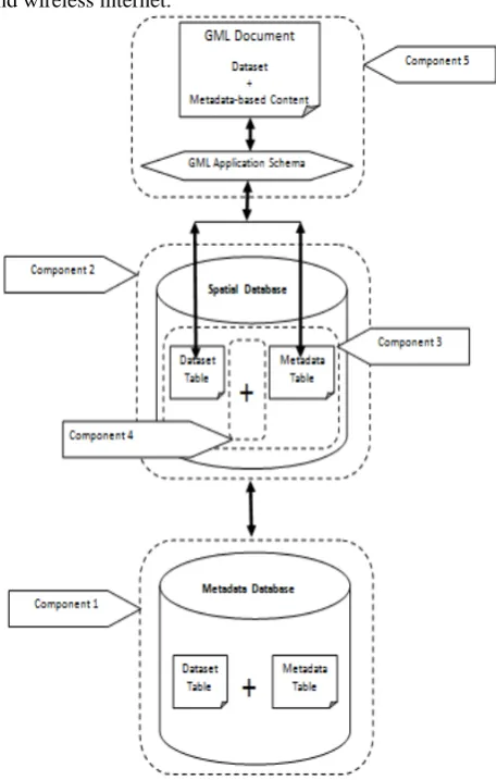
Fig. 4 illustrated the components that involve in the data integration process of spatial data and metadata in order to accommodate and exchange both values.
A. Metadata Database
The management of Business Intelligence components and Business Intelligence contents entail the need to document information about both technical configurations; for example, regarding the connection to the source systems, and the business related background, e.g., the semantics behind the data and the transformation steps which is done with metadata storage repositories [19]. During the process of loading the data from different database, the structured data will be stored in the Spatial database, while unstructured data will be loaded into Metadata Database. The coding process for different database was developed using PHP platform. For unstructured data, this type of data will be handled first by the Content Management Systems in the Metadata Database. This system is responsible for unstructured data manipulation process and the metadata creation process. The outcome of these processes will be a metadata-based content and will be stored in the GeoNetwork database for the next synchronization process.
Metadata database acts as temporary storage repository for metadata. This storage repository is responsible for managing the information from heterogeneous platforms that may contain with structured and unstructured form. Moreover, this database will store information about the underlying data sources. This information is used by system components (such as the query transformer, query postprocessor and source registration) or by users when formulating queries [19].
The database development also was developed using PHP platform which is accessible through wired internet and wireless internet.
Fig. 4: Components of the Spatial-metadata Integration Model
B. Spatial Database
The second component is the data storage repository that responsible to store spatial and non-spatial tables including dataset and metadata. During the integration process of spatial data and metadata, the context of the integration is generally being translated into an appropriate set of queries (both structured and unstructured). In order to implement the function of spatial database, PostgreSQL spatially enable with PostGIS are being selected for this purpose.
C. Data Tables
The third component that involves in the Spatial-metadata integration process would be the data tables in the Spatial database. These tables store two types of data such as dataset and metadata. The columns in dataset table will be contained with the attributes and geometry data type while the metadata table(s) will embrace the ISO 19115:2003 elements [25]–[27].
D. Relationship Definition
E. Middleware System
There have been several publications on metadata integration framework for Business Intelligence in the past. Most of these frameworks are built around the concept of the Data Warehouse and focus on the technical processing of structured data. The metadata integration framework in Tukwila for example uses a single data source catalogue to store metadata that is being obtained from several sources [28]. International Business Machine (IBM) introduces software based upon a "middleware" architecture that provides an integrated access layer across the various data sources being integrated. This integration model also as oppose to the data warehousing approach in which all data is being loaded and centralized at a single place for further analysis.
The fifth component of Spatial-metadata integration model in the proposed model is a middleware system that responsible to handle the dataset and metadata integration processes such as storing both dataset and metadata values along with their relationship and exchanging them over the Web and between different users as well as spatial systems elements [25]–[27]. This middleware system acts as a hub that communicates with several components. Moreover, some schemas that can convert and translate data formats will be included during the integration process. The middleware system also involves in data modification activities such as to extract the structure of the results which are unstructured and to offer in this way structured data items to the Access layer. Moreover, it can be used as a buffer for the returned results [29].
Various existing data exchange formats (e.g. GML, KML, XML, and MEF (Metadata Exchange Format)) have being studied and this paper has selects the Geography Markup Language (GML) that have the capabilities to support the encoding, transferring and storage of spatial data characteristics as well as metadata values elements [25]– [27]. Furthermore GML is an XML grammar designs to provide features that can support for spatial information environment through the web platforms [22].
VI.CONCLUSIONS
This paper discusses a new and efficient spatial-metadata management for decision-making management and positions them in the Business Intelligence environment. By adapting Business Intelligence approach in the integration process, help the organisation in leveraging the business information assets effectively, enables stakeholders with better decision making capabilities and helps organisation achieve desired goals, and help organisation with improved information management and better decision making.
The design of this framework is not just focusing to the system that handling the integration process of spatial data but also giving special emphasis to the unstructured data management system that not only to deal with structured data but also capable for handling and transforming unstructured data into useful information that can be managed as a valued enterprise asset.
The spatial data integration system in this framework is based on geographical environment and incorporates with geospatial web services features such as presentation, geographic and thematic selection and the exchange of
spatial data that can support Spatial Data Infrastructure (SDI). Overall applications in this system is distinguishes between already existing methods by emphasising on new technologies like Web 2.0 and took advantage of its technologies such as proactive alerts and notifications, event driven/ real time/ instant access to information, advanced analytics, enterprise Integration, improved visualization, Rich Interfaces (RIA), etc. that enable business stakeholders to be able to quickly adapt to new business requirements and evolving sources of information.
The design of this framework is based on the Coupling Information Systems Techniques which the integration processes will be implemented by using middleware system. Therefore, the main component during data integration process in this framework is the middleware system that plays an important role as a central control point for every component of this model.
ACKNOWLEDGMENT
Appreciation conveyed to Sultanah Nur Zahirah Digital Learning Center, Library of Universiti Sultan Zainal Abidin, and Faculty of Science & Technology for contribution of above data and information.
REFERENCES
[1] Alqarni, A.A.; Pardede, E. (2012, September). Integration of Data
Warehouse and Unstructured Business Documents. Network-Based Information Systems (NBiS.). [Online]. pp.32,37, 26-28. Available: http://ieeexplore.ieee.org/
[2] Plejic, B.; Vujnovic, B.; Penco, R.(2008, December). Transforming
unstructured data from scattered sources into knowledge. IEEE International Symposium on. [Online]. pp.924, 927, 21-22. Available: http://ieeexplore.ieee.org/
[3] Dasgupta, Arindam, and S. K. Ghosh. "A framework for ubiquitous
geospatial information integration on mobile device using orchestration of geoservices." International Journal Of UbiComp (IJU) 1, no. 3 (2010): 69-88.
[4] Nebert, D., (2004), Developing Spatial Data Infrastructures: The
SDI Cookbook Ver 2.0. Technical Working Group Chair, GSDI.
[5] Daratech (2011), GIS/Geospatial Sales up 10.3% to US$4.4 billion
Growth Forecast to Top 8.3% in 2011. Cambridge, MA, USA: Daratech, Inc.
[6] deegree. (2010). deegree Web Feature Service v2.5. [Online].
Available: http://download.deegree.org
[7] Batcheller, J.K., (2008), Automating Geospatial Metadata
Generation – An Integrated Data Management and Documentation
Approach. Computers and Geosciences, 34: 387--‐398.
[8] Blumberg, R., & Atre, S. (2003). The problem with unstructured
data. DM REVIEW, 13, 42-49.
[9] Najar, C. (2006). A model-driven approach to management of
integrated metadata-spatial data in the context of spatial data infrastructures. Zürich: Inst. für Geodäsie u. Photogrammetrie, ETH.
[10] M. Friedman, A. Y. Levy, and T. D. Millstein, “Navigational Plans
For Data Integration.” In AAAI/IAAI, 1999, pp. 67–73.
[11] M. R. Genesereth, A. M. Keller, and O. M. Duschka, “Infomaster:
An Information Integration System.” in SIGMOD Conference, 1997, pp. 539–542.
[12] M. Lenzerini, “Data Integration: A Theoretical Perspective.” in
PODS, 2002, pp. 233–246.
[13] Ziegler, Patrick " User-Specific Semantic Integration of
Heterogeneous Data: What Remains to be Done? " Building the Information Society 156 (2004): 3-12. Print.
[14] R. J. Vidmar. (1992, August). On the use of atmospheric plasmas as
electromagnetic reflectors. IEEE Trans. Plasma Sci. [Online]. 21(3). pp. 876—880. Available: http://www.halcyon.com/pub/journals/21ps03-vidmar
[15] Jayaraman, Gayathri. A mediator-based data integration system for
[16] K. C.-C. Chang, B. He, and Z. Zhang, “MetaQuerier over the Deep Web: Shallow Integration across Holistic Sources.” in IIWeb - VLDB, 2004.
[17] Sonia Bergamaschi, Francesco Guerra, and Maurizio Vincini. A
Peer-to-Peer Information System for the Semantic Web. In Proceedings of the International Workshop on Agents and Peer-to-Peer Computing (AP2PC 2003), July 2003.
[18] Watson, H.J.; Wixom, Barbara H. (2007, September). The Current
State of Business Intelligence. Computer. [Online]. 40(9). pp.96, 99. Available: http://ieeexplore.ieee.org/
[19] Henning Baars and Hans-George Kemper. 2008. Management
Support with Structured and Unstructured Data-An Integrated Business Intelligence Framework. Inf. Sys. Manag. 25, 2 (March 2008), 132-148.
[20] Kalantari, M., Rajabifard, A. and Olfat, H. (2009). "Spatial
Metadata Automation:A New Approach", Proceedings Spatial Science Conference 2009 (SSC2009), September 28- October 2, Adelaide, Australia, pp. 629-635.
[21] Kalantari, M., Olfat, H. and Rajabifard, A. (2010). "Automatic
Metadata Enrichment: Reducing Spatial Metadata Creation Burden through Spatial Folksonomies", in Rajabifard, A., et al. (Eds). Spatially Enabling Society. Luven University Press, pp. 119-129.
[22] 10 Huang, C. H., RueyChuan, T., PoDeng, D., and MingLee, H.
(2009). Building GML-Native Web-Based Geographic Information Systems, Computers and Geosciences, 35(9): 1802-1816.
[23] GeoServer.(2011). Complex Features [Online]. Available:
http://docs.geoserver.org
[24] Williamson, I., Rajabifard, A., Feeney, M.-E. F. (2003). Developing
Spatial Data Infrastructures, from Concept to Reality. New York, Taylor&Francis.
[25] Olfat, H., Kalantari, M., Rajabifard, A., Williamson, I., Pettit, C.,
Williams, S. (2010a). "Exploring the Key Areas of Spatial Metadata
Automation Research in Australia", GSDI 12 World Conference, October 19-22, Garden city, Singapore.
[26] Olfat, H., Rajabifard, A. and Kalantari, M. (2010c), A
synchronisation approach to automate spatial metadata updating process, Coordinates Magazine, VI(3): 27-32.
[27] Rajabifard, A., Kalantari, M. and Binns, A. (2009). "SDI and
Metadata Entry and Updating Tools", in Loenen, B. v., Besemer, J. W. J. and Zevenbergen, J. A. (Eds). SDI Convergence. Research, Emerging Trends, and Critical Assessment, Delft, pp. 121-136.
[28] S. B. Navathe, A. K. Tanaka, and S. Chakravarthy, “Active
Database Modeling and Design Tools: Issues, Approaches, and Architecture.” IEEE Data Engineering Bulletin, vol. 15, no. 1-4, pp. 6–9, 1992.
[29] Rajawat, A. S., Dwivedi, U., Jain, D. C., & Upadhyay, A. R. (2011,
December). Integration of data source using query processing for distribute heterogeneous environment. In Engineering (NUiCONE), 2011 Nirma University International Conference on (pp. 1-7). IEEE.
[30] Haas, L. (2006). Beauty and the beast: The theory and practice of
information integration. In Database Theory–ICDT 2007 (pp. 28-43). Springer Berlin Heidelberg.
[31] Mueller, S.H.; Krueger, J.; Schaner, J.; Tinnefeld, C.; Zeier, A.
(2009, October). Controlled natural language for information integration. IE&EM '09. 16th International Conference on. [Online]. pp.717,721. Available:URL:http://ieeexplore.ieee.org/
[32] Olfat, H., Rajabifard, A. and Kalantari, M. (2010b). "Automatic
Spatial Metadata Update: a New Approach", XXIV FIG International Congress 2010, April 11-16, Sydney, Australia.
[33] Zachary G. Ives, Daniela Florescu, Marc Friedman, Alon Levy, and
![Fig. 1: Example of Business Intelligence framework [18]](https://thumb-us.123doks.com/thumbv2/123dok_us/7822190.1296080/2.595.305.547.303.450/fig-example-business-intelligence-framework.webp)
![Fig. 2: Example of Information Integration framework [19].](https://thumb-us.123doks.com/thumbv2/123dok_us/7822190.1296080/3.595.52.292.166.347/fig-example-information-integration-framework.webp)