Improved long-term coastal management
as a result of
a large-scale spatial perspective
Improved long-term coastal management
as a result of
a large-scale spatial perspective
Enschede, May 2008
Master’s Thesis of: E.M. Horstman
Water Engineering & Management University of Twente
Supervisors:
Prof. dr. S.J.M.H. Hulscher Water Engineering & Management University of Twente
Dr. K.M. Wijnberg
Water Engineering & Management University of Twente
Dr. ir. C.M. Dohmen-Janssen Water Engineering & Management University of Twente
Ing. A.J.P. Helder
Environmental Quality & Impact Assessment Witteveen+Bos
Ir. A.J. Smale Reference: ZZMI5044/nija4/001
Coastal & River Engineering Project code: ZZMI5044
Improved long-term coastal management as a result of a large-scale spatial perspective
Summary
Problem definition & research objective
Present coastal management policy in the Netherlands mainly consists of reacting to observed changes and acting in anticipation of expected short-term changes for the next 50 years. Longer-term
developments are only accounted for in outlooks that are applied for considering the no-regret level of proposed projects. Projects forthcoming from this approach often have a confined spatial scope.
Meanwhile, no reliable expectations are available on the requirements of the coastal defences within the next 200 years. It is also unknown whether this long-term perspective may introduce new insights with respect to the existing coastal management policy. A quick scan on the issue of scaling up in both coastal management and water management in general, shows that this long-term perspective increases the relevance of a larger spatial scale perspective. Until now however, no systematic studies have been accomplished into the potential advantages of developing long-term strategies for enhancing the coastal defences at larger spatial scales. Therefore, the goal of this research is:
To establish whether a long-term perspective raises the need for new coastal management strategies at a larger spatial scale than the present coastal management practice and to explore the consequences of implementing such new coastal management strategies.
Outline of this research
To find out whether a long-term perspective introduces new insights to coastal management, this research presents the results of a case study based on the area consisting of the mainland coasts of the provinces of Noord-Holland and Zuid-Holland in the Netherlands. The first step consists of a study into long-term climate change effects and their impacts on coastal safety. Next, eight coastal management strategies are derived for preserving the present safety level of the coastal defences up to 200 years from now. Afterwards, an assessment methodology is set-up and applied in order to find out how these proposed strategies compare to each other. This brings us to some new insights on the implications of a long-term perspective for coastal management policy.
Future developments
Available literature on climate change impacts is applied to derive three scenarios for the increasing hydraulic boundary conditions for the coastal defences up to 2200. Additionally, it is supposed that the bed levels of the coastal zone seaward of the dunetoes will keep up with sea level rise due to ongoing nourishments. Subsequently, the safety of the future coastal defences is assessed according to the increased hydraulic boundary conditions. The existing assessment method for coastal defences is applied, including a longshore component to account for longshore discontinuities in the dune profiles. These assessments show that by the year 2200, more than 70% of the coastal defences will be
disapproved if the most extreme climate change scenario will come true. For the intermediate and the lower scenarios, these figures are 60% and 40% respectively.
Spatial scales
Improved long-term coastal management as a result of a large-scale spatial perspective
Coastal management strategies are considered at four different spatial scales within this study:
▪ Uniform coast; one solution for the entire study area.
▪ Large spatial scale; separating the southern, densely populated part and the northern, less densely populated part of the study area.
▪ Intermediate spatial scale; dividing the study area into twelve longshore sections according to major land use characteristics.
▪ Small spatial scale; dividing the study area in many short longshore sections that are related to very specific characteristics of each area (e.g. land use and attributes of the defences).
Coastal management strategies
Different (existing) measures are connected to these spatial scales. This way, eight different coastal management strategies are created for preserving the present safety level of the coastal defences over the next 200 years. The proposed strategies are:
▪ Two islands in front of the entire coast of the study area.
▪ Artificial but dynamic sandbanks in front of the entire coast.
▪ A new row of foredunes in front of the existing foredunes for the entire coast.
▪ An island in front of the southern part of the study area and new foredunes at the northern part.
▪ New foredunes in front of the southern part of the coast and sandbanks at the northern part.
▪ An intermediate scale seaward strategy combining seaward dune extensions with new sandbanks and artificial reefs, depending on the major land use functions.
▪ An intermediate scale landward strategy consisting of landward dune extensions and some minor seaward dune extensions, depending on the major land use functions.
▪ The small scale basic alternative representing the continuation of present small-scale coastal management policies being very well adjusted to the specific, local land use functions and showing a major longshore variation in the measures for improving the coastal defences.
The required dimensions of the measures within these strategies are derived for both the highest and the lowest climate change scenarios.
Assessment framework
Until now, little is known on how new coastal management strategies compare to the continuation of the present coastal management policy. Moreover, scientific publications still mainly concentrate on the technical feasibility of new strategies. This study compares the proposed coastal management strategies to the basic alternative by applying a mainly qualitative assessment method that is partly based on rough estimates of the (socioeconomic) costs and benefits. All strategies are assessed on a wide range of criteria, representing costs, welfare impacts, non-welfare impacts (intrinsic value of nature) and some other criteria (technical complexity, robustness, phasing and governmental complexity).
Different views are set-up that each award different weights to the criteria and leave some criteria out of the assessment. These views are applied to explore the influence of different policy outlooks. Since the assessments on some of the criteria are quite uncertain, this study only considers significant values of the total scores on these views. Minor deviations from the score of the basic alternative are left out of the analysis. A sensitivity analysis shows that this method results into rather stable results.
Conclusions
Improved long-term coastal management as a result of a large-scale spatial perspective
It turns out that there are three alternative strategies that show some major advantages over the basic alternative, both when the highest and the lowest climate scenarios are considered:
▪ The uniform coast strategy with a new row of foredunes in front of the entire coast. This strategy is assessed best from a sustainability point of view since a new, smooth coastline is established. Moreover, new nature will be created which might be useful for recreational purposes.
▪ The large scale strategy with an island in front of the southern part of the study area and new foredunes for the northern part is assessed best from a spatial development point of view since new space would be created to relieve the ever-increasing densities in this region. However, it is assessed negative from a risk averting point of view.
▪ The intermediate scale landward strategy, consisting of landward dune extensions and some minor seaward dune extensions depending on the major land use functions, is assessed best from a risk averting point of view. This is caused by its rather low maintenance costs and the possibility to separate the construction in phases.
The uniform strategy with two islands in front of the entire coast of the study area also shows some major advantages in comparison to the basic alternative, especially on spatial development. However, this goes along with significant disadvantages for some other views like sustainability.
A main characteristic of those strategies that are assessed best is that they aim at maintaining the longshore smooth, concave shape of the coast. This shape represents some sort of natural equilibrium situation of the coastal morphology, in contrary to the disruptions of this smooth coastline caused by the basic alternative. So accounting for and cooperating with the natural dynamics of the coastal system could significantly contribute to improving coastal management. Possibilities to do so increase when a larger spatial scale perspective is applied for developing coastal management strategies.
This research shows that rankings of the proposed coastal management strategies do not change too much for the two climate change scenarios that are studied, despite of the large uncertainties that are inherent to the long-term future. For more detailed designs that are based on the proposed strategies however, these uncertainties are certainly important and therefore flexible solutions should be preferred. This should enable the possibility of the coastal defences to be extended over time in accordance with the latest predictions of the boundary conditions for the next decades. From this point of view, static solutions are less preferable.
The results of this study indicate that a solid analysis can be accomplished of the significant advantages and disadvantages of different strategies for long-term coastal management, although future
uncertainties are quite large. So there is no need to wait with establishing a new direction for coastal management until all future uncertainties are reduced as much as possible.
Improved long-term coastal management as a result of a large-scale spatial perspective
Samenvatting
Probleemdefinitie & doelstelling
Het huidige beleid voor het kustbeheer in Nederland laat zich voornamelijk kenmerken door het
reageren op waargenomen veranderingen en het anticiperen op korte termijn veranderingen die voor de komende 50 jaar verwacht worden. Ontwikkelingen op de langere termijn worden slechts meegenomen in een lange-termijn doorkijk om het no-regret gehalte van een voorgesteld project te beoordelen. Projecten die uit deze benadering voortkomen, hebben vaak een beperkte ruimtelijke scope.
Er zijn echter geen betrouwbare verwachtingen beschikbaar met betrekking tot de dimensies van de benodigde kustverdediging voor de komende 200 jaar. Het is ook onduidelijk of een dergelijk lange-termijn perspectief zal leiden tot nieuwe inzichten ten opzichte van het huidige beleid voor het kustbeheer. Een quick scan naar nut en noodzaak van schaalvergroting in zowel het kustbeheer als watermanagement in het algemeen, geeft al een indicatie dat een lange-termijn perspectief de vraag om een grootschaliger ruimtelijke benadering doet toenemen. Tot op heden zijn er echter nog geen systematische studies uitgevoerd naar de potentiële voordelen van het ontwikkelen van lange-termijn kustversterkingsstrategieën met een grootschaliger ruimtelijke benadering. Het doel van deze studie is daarom:
Vaststellen of een lange-termijn benadering leidt tot een behoefte aan nieuwe strategieën voor het kustbeheer die worden gekenmerkt door een grotere ruimtelijke schaal dan het huidige kustbeheer, en nagaan welke consequenties de implementatie van dergelijke nieuwe strategieën voor het kustbeheer met zich mee brengt.
Opzet van het onderzoek
Om na te kunnen gaan of een lange-termijn benadering nieuwe inzichten met betrekking tot het kustbeheer oplevert, worden in dit onderzoek de resultaten gepresenteerd van een case study die is gebaseerd op de kust van het vasteland van de provincies Noord-Holland en Zuid-Holland. De eerste stap van het onderzoek bestaat uit een inventarisatie van de lange-termijn effecten ten gevolge van de voorspelde klimaatveranderingen en de impact van die effecten op de veiligheid geboden door de kustverdediging. Vervolgens zijn acht kustverdedigingsstrategieën opgesteld voor het behoud van het huidige veiligheidsniveau van de kustverdediging tot het jaar 2200. Tot slot is een beoordelingskader opgezet en toegepast op de voorgestelde strategieën om ze onderling te kunnen vergelijken. Dit heeft geleid tot enkele nieuwe inzichten over de betekenis van een lange-termijn benadering voor het beleid rond het kustbeheer.
Toekomstige ontwikkelingen
Uit de beschikbare literatuur over de potentiële gevolgen van de klimaatveranderingen zijn voor het jaar 2200 drie scenario’s afgeleid voor de toename van de hydraulische randvoorwaarden waaraan de kustverdediging blootgesteld kan worden. Daarnaast wordt verondersteld dat ten gevolge van het voortzetten van het suppletiebeleid het bodemniveau van het deel van de kustzone zeewaarts van de duinteen even snel stijgt als de zeespiegel. Vervolgens is de veiligheid van de toekomstige
Improved long-term coastal management as a result of a large-scale spatial perspective
Ruimtelijke schalen
Deze studie identificeert twee redenen waarom toekomstige ontwikkelingen de behoefte doen toenemen om kustbeheersstrategieën op grotere ruimtelijke schalen te benaderen. In de eerste plaats heeft de beoordeling van de zeeweringen voor de verslechterende randvoorwaarden uitgewezen dat de ruimtelijke omvang van de zwakke schakels in de toekomst sterk zal toenemen. Dit leidt inherent tot de behoefte om ook op grotere ruimtelijke schalen naar strategieën voor de versterking van de
kustverdediging te zoeken. Daarnaast zijn er mogelijke maatregelen voor de versterking van de kustverdediging die niet geschikt zijn om op (zeer) beperkte schaal toegepast te worden. Dus zowel vanuit de probleemzijde als vanuit de oplossingszijde ontstaat de behoefte aan een grootschaliger ruimtelijk perspectief. Anderzijds zijn er overigens ook mogelijke maatregelen die juist niet geschikt zijn om op grote schaal toegepast te worden. Daarom zijn verschillende ruimtelijke schaalniveaus meegenomen.
Er worden vier verschillende ruimtelijke schaalniveaus onderscheiden bij het zoeken naar (nieuwe) kustbeheersstrategieën:
▪ Uniforme kust; hierbij wordt één oplossing toegepast over de gehele lengte van de kust.
▪ Grote ruimtelijke schaal; waarbij onderscheid wordt gemaakt tussen het zuidelijke, dichtbevolkte gedeelte van het gebied en het noordelijke gedeelte dat minder dicht bevolkt is.
▪ Tussenliggende ruimtelijke schaal; die het studiegebied in twaalf kustlangse secties verdeelt naar aanleiding van overheersende landgebruikspatronen.
▪ Kleine ruimtelijke schaal; waarbij het studiegebied in vele korte kustlangse secties wordt verdeeld naar aanleiding van specifieke lokale eigenschappen als landgebruik en kenmerken van de
zeewering.
Strategieën voor het kustbeheer
Verschillende (bestaande) maatregelen ter versterking van de kustverdediging zijn verbonden aan deze ruimtelijke schalen. Hieruit zijn acht verschillende kustbeheersstrategieën afgeleid om de het huidige veiligheidsniveau dat wordt geboden door de zeeweringen ook gedurende de komende 200 jaar nog te kunnen garanderen. De voorgestelde strategieën zijn:
▪ Twee eilanden die samen de gehele kust van het studiegebied afschermen.
▪ Kunstmatige maar dynamische zandbanken voor de hele kust.
▪ Een nieuwe rij voorduinen (zeereep) voor de bestaande voorduinen, langs de hele kust.
▪ Een eiland voor de kust van het zuidelijke gedeelte van het studiegebied en een nieuwe rij voorduinen voor het noordelijke gedeelte.
▪ Een nieuwe rij voorduinen voor de bestaande duinen in het zuidelijke deel van het studiegebied en kunstmatige, dynamische zandbanken voor het noordelijke deel.
▪ Een zeewaartse strategie volgens het middelste ruimtelijke schaalniveau, waarbij zeewaartse duinverbredingen worden afgewisseld met nieuwe zandbanken en kunstriffen, afhankelijk van het overheersende type landgebruik.
▪ Een landwaartse strategie volgens de tussenliggende schaal, waarbij landwaartse duinuitbreidingen worden afgewisseld met enkele kleinschalige zeewaartse duinverbredingen. De soort uitbreiding hangt af van het overheersende type landgebruik.
▪ Een kleinschalig basisalternatief dat uitgaat van de voortzetting van het huidige kleinschalige beleid voor kustbeheer dat erg goed afgestemd is op de specifieke, lokale landgebruikfuncties en waardoor in kustlangse richting een sterke variatie ontstaat in de gekozen maatregelen ter versterking van de kustverdediging.
Improved long-term coastal management as a result of a large-scale spatial perspective
Vergelijkingskader
Tot op heden is er weinig bekend over hoe de consequenties van nieuwe kustbeheersstrategieën zich verhouden tot de consequenties van een voortzetting van het huidige beleid voor het kustbeheer. Daarnaast richten wetenschappelijke publicaties zich nog vooral op de technische haalbaarheid van nieuwe strategieën. In deze studie worden de voorgestelde strategieën voor het kustbeheer vergeleken met het basisalternatief door middel van een afwegingsmethode die hoofdzakelijk kwalitatief van aard is. De onderbouwing is echter deels gebaseerd op ruwe schattingen van de (sociaal-economische) kosten en baten. Alle strategieën zijn beoordeeld op een gevarieerde reeks criteria representatief voor de kosten, welvaartseffecten, niet-welvaartseffecten (intrinsieke waarde van natuur) en een aantal andere criteria (technische complexiteit, robuustheid, faseerbaarheid en politieke complexiteit).
Daarnaast worden verschillende perspectieven bepaald die elk een verschillende gewichtenset aan de criteria toekennen, waarbij sommige criteria soms ook buiten beschouwing worden gelaten. Deze perspectieven worden toegepast om na te gaan hoe verschillende beleidsstandpunten de beoordeling van de kustversterkingsstrategieën kunnen beïnvloeden. En omdat de beoordelingen op sommige van de criteria grote onzekerheden bevatten, wordt in deze studie alleen naar significante waarden van de totaaloordelen volgens deze perspectieven gekeken. Kleine afwijkingen van de eindscores ten opzichte van de score van het basisalternatief worden niet meegenomen in de analyse. Een gevoeligheidsanalyse van de eindresultaten toont aan dat deze werkwijze resulteert in redelijk stabiele uitkomsten.
Conclusies
Enkele algemene conclusies worden gevonden wanneer wordt gekeken naar de resultaten van de beoordelingen van de voorgestelde kustbeheersstrategieën volgens alle beleidsperspectieven en zowel voor het hoogste als voor het laagste klimaatscenario. Ten eerste blijkt de kleinschalige strategie die is gebaseerd op het voortzetten van het huidige beleid voor de kustbeheersing niet de beste strategie te zijn. Andere strategieën bieden betere kansen voor het versterken van de kustverdediging en de daarmee gepaard gaande ruimtelijke consequenties. Het basisalternatief (de kleinschalige strategie) scoort voornamelijk goed vanuit een perspectief gericht op de op dit moment belangrijkste criteria en vanuit een risicomijdend perspectief.
Het blijkt dat er drie alternatieve strategieën zijn, die uitgaan van een grootschaliger ruimtelijke benadering en die grote voordelen laten zien ten opzichte van het basisalternatief, zowel wanneer van het hoogste als het laagste klimaatscenario wordt uitgegaan:
▪ De strategie voor een uniforme kust me een nieuwe rij voorduinen voor de bestaande zeereep. Deze strategie wordt als beste beoordeeld vanuit een duurzaamheidsperspectief doordat een nieuwe, gladde kustlijn wordt gevormd.
▪ De strategie ontworpen op een groot ruimtelijk schaalniveau waarbij een eiland is voorzien voor het zuidelijke deel van de kust van het studiegebied en nieuwe voorduinen voor het noordelijke deel, wordt als beste beoordeeld vanuit een perspectief gericht op ruimtelijke ontwikkeling. Dit omdat er nieuwe ruimte beschikbaar komt om de immer toenemende ruimtelijke druk in het zuidelijke deel van het studiegebied te verlichten. Deze strategie is echter negatief beoordeeld vanuit een risicomijdend perspectief.
▪ De landwaartse strategie die is ontworpen op een tussenliggende ruimtelijke schaal en voornamelijk bestaat uit landwaartse duinuitbreidingen, wordt als beste beoordeeld vanuit een risicomijdend perspectief. Dit wordt veroorzaakt door het feit dat de onderhoudskosten laag zijn en door de mogelijkheid om de aanleg te faseren.
Daarnaast toont de uniforme strategie met twee eilanden voor de kust van het studiegebied vanuit enkele perspectieven ook belangrijke voordelen ten opzichte van het basisalternatief, vooral vanuit het perspectief gericht op ruimtelijke ontwikkeling. Dit gaat echter samen met een aantal significante nadelen vanuit enkele andere perspectieven waarvan duurzaamheid de belangrijkste is.
Improved long-term coastal management as a result of a large-scale spatial perspective
evenwichtssituatie van de kust, in tegenstelling tot de verstoringen van deze gladde kustlijn die
voortkomen uit het basisalternatief. Rekening houden en samenwerken met de natuurlijke dynamiek van het kustsysteem lijkt dus een significante bijdrage te kunnen leveren aan de verbetering van het kustbeheer. De mogelijkheden hiertoe nemen toe wanneer een grootschaliger ruimtelijke benadering wordt toegepast bij het ontwikkelen van nieuwe kustbeheersstrategieën.
Dit onderzoek laat zien dat de voorkeur voor de voorgestelde kustbeheersstrategieën niet veel verandert voor de twee bestudeerde klimaatscenario’s, ondanks de grote onzekerheden die de verre toekomst met zich meebrengt. Voor concrete ontwerpen gebaseerd op de voorgestelde strategieën zijn deze
onzekerheden echter wel degelijk van belang en moet er toch vooral de voorkeur gegeven worden aan flexibele oplossingen. Dit moet er voor zorgen dat het mogelijk blijft om de kustverdedigingen met de tijd te versterken naar aanleiding van de laatste inzichten in en voorspellingen van de randvoorwaarden voor de komende decennia. Vanuit dit opzicht zijn statische oplossingen, die zich minder makkelijk laten aanpassen, minder gunstig.
De resultaten van deze studie tonen aan dat een betrouwbare analyse gemaakt kan worden van de significante voordelen en nadelen van verschillende strategieën voor het lange-termijn kustbeheer, ook al zijn de onzekerheden die de toekomst met zich meebrengt vrij groot. Er is dus geen noodzaak om te wachten met het vaststellen van een nieuwe richting voor het kustbeheer totdat alle toekomstige onzekerheden zoveel mogelijk zijn teruggedrongen.
Improved long-term coastal management as a result of a large-scale spatial perspective
Preface
About a year ago I started looking for an interesting topic for my master’s thesis. But what is
interesting? This is quite a hard question when you are interested in a lot of topics. Unfortunately, I was not allowed to graduate on a study into the preparation of the best salad or baking the most delicious apple pie. But with great help of some people at the University, I chose to dedicate the research for my thesis to coastal management. Quite important actually, since where to bake and enjoy your apple pie if your house is located at the bottom of Lake Holland?
After studying lots of literature, I knew how coastal management in the Netherlands is arranged right now. But I also identified some problems that might occur when this same coastal management policy is continued for the next two centuries. The expected climate change effects cause the requirements for our coastal defences to increase over time. This made me ask whether such a long-term perspective would potentially increase the need for some changes to our coastal management policy.
The people who helped me with finding this topic for my master’s thesis fortunately where also willing to supervise me during the past six months in which I performed this study. Moreover, Witteveen+Bos was prepared to facilitate my research. I was given the opportunity to work at their office in Deventer and to bother their people with all my questions. And there were lots of questions since some specific topics of this research were still quite undeveloped. How to assess the safety of the dunes two centuries from now? How to compare coastal management strategies for the next 200 years? Doing this research was a bit like rowing a tiny boat on a mountain river. Sometimes I could just accomplish some plans and the research went on just with the flow, but at some other times it was really hard when I did not exactly now how to solve new problems and my boat got in some wild rapids. Luckily, there were always people to get me out of these troubles. I hope that I have finally reached my destination and that this thesis may contribute somehow to a sustainable preservation of the safety of our coastal defences.
I would like to thank all my supervisors for their support and their enthusiasm. Hans, your critical attitude and your never-ending interest in the progression of my research really helped me to improve this thesis. The two-weekly meetings with Kathelijne really kept me on track, she always reminded me of the goal of my study. Assessing different strategies for coastal management would have failed without the talks with Alfons in Rotterdam. It was nice to be there now and then. Suzanne and Marjolein, thanks for reading my extensive reports and for your critical notes. Some other people that really helped me are Eveline Buter (Witteveen+Bos) and Jan Mulder (University of Twente). Your input was quite important to me and I am grateful you were willing to lend me some of your knowledge. I also thank all other people who have contributed to this study.
I would also like to thank all my colleagues at Witteveen+Bos for the nice time I spend with them, when there were birthday cakes, just at lunch and at all other breaks. Carlijn, Marieke and Marloes, it was nice spending the daily train journeys with you. Thanks to my friends and family too for your ongoing interest for this project, although it was quite hard to understand now and then what I was really doing. And thanks to Peter for the many lunch-walks when I really needed to get away from my computer.
Finally I want to thank my mother and my sister. Thanks for all the meals that were (almost) ready when I came back from Deventer. And for always listening to my complaints when things did not work out the way I wanted them to do. I would not have managed this without both of you! Dad, I am proud of you and I hope you would have been proud of me too…
Improved long-term coastal management as a result of a large-scale spatial perspective
1.1 Present situation & future developments ... 1
1.2 Scale issues ... 2
1.3 Problem analysis ... 4
1.4 Research objective ... 7
1.5 Research questions ... 7
1.6 Scope ... 8
1.7 Outline of this study ... 10
2 Large-scale safety assessments of the coastal defences ... 11
2.1 Climate change effects ... 11
2.2 Continued nourishment policy ... 13
2.3 Assessment regulations ... 17
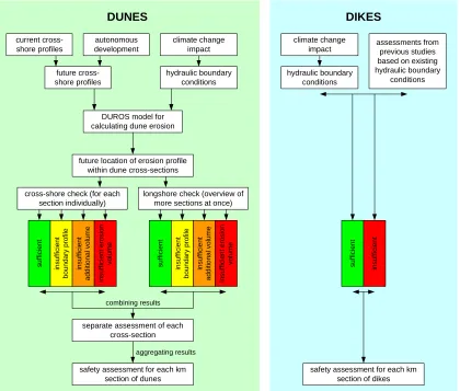
2.4 Calculating safety of dunes ... 18
2.5 Determining safety of dikes ... 22
2.6 Safety assessments ... 22
2.7 Concluding ... 26
3 Coastal management strategies for 2200 ... 27
3.1 Available measures ... 27
3.2 Different spatial scales... 29
3.3 Coastal management strategies ... 32
4 Comparing coastal management strategies ... 41
4.1 Assessment methodology ... 41
4.2 Assessment of coastal management strategies ... 47
4.3 Impact of less extreme climate change ... 50
4.4 Resulting assessments for different policy views ... 52
4.5 Sensitivity analysis ... 57
4.6 Concluding ... 62
5 Discussion ... 65
5.1 Long-term perspective vs. present policy ... 65
5.2 Knowledge gaps and major assumptions ... 67
5.3 Coping with fundamental uncertainties ... 68
5.4 Previous studies and policies on coastal management ... 69
5.5 Recent studies and initiatives ... 70
Improved long-term coastal management as a result of a large-scale spatial perspective
Appendices ... 89
A Spatial & socioeconomic developments ... 91
B Scientific climate change scenarios ... 97
C Policy climate change scenarios ... 101
D Subsidence ... 103
E Safety assessment directives ... 105
F Hydraulic boundary conditions ... 117
G Matlab script of DUROS-plus ... 123
H Longshore safety assessments of dunes ... 125
I Available coastal management solutions ... 131
J Dimensioning coastal management strategies ... 143
K Coastal management strategies for 2200 ... 163
L Assessment methodology ... 171
M Assessing monetary impacts ... 175
N Values for quantification and monetarization of impacts ... 181
O Assessing coastal management strategies ... 191
P Impact lower climate change scenario ... 229
Q Ranking coastal management strategies ... 237
Improved long-term coastal management as a result of a large-scale spatial perspective
1
Introduction
In this introductory chapter, the problem that is considered in this study will be introduced. First, the present situation of low-lying coastal areas is confronted with expected climate change effects and socioeconomic developments, in order to state the importance of adequate coastal management. Next, some attention is given to the issue of scales in water management since temporal and spatial scales are at the heart of this study. Then, the problem analysis states which problems are faced in managing the coastal defences. A problem definition will be derived. Based on this information, the research
objective is stated and the major research questions are defined. Afterwards, the scope of this study is confined. In the final section, the outline of the remainder of this report is presented.
1.1
Present situation & future developments
Recent events and developments created a large interest in flood protection of low-lying coastal areas. One of these events is the disaster in New Orleans caused by hurricane Katrina (almost 2000 casualties), which clearly showed the threats of living in coastal areas and underlined the importance of adequate coastal defences. At the same time, effects of the expected climate change increase concerns about the present and future adequacy of coastal defence systems all over the world. Rising sea levels and large uncertainties regarding possible changes in the occurrence and strength of storms are among those effects of climate change and are increasing the pressure on coastal defences [IPCC, 2007; KNMI, 2006].
Together with the worldwide intensification of the extreme conditions at the seaside of the coastal defences, at the landside the number of people to be protected keeps growing.
Therefore, the worldwide attention for the potential effects of climate change and for improving coastal defences is timely.
The Netherlands faces these problems too. About 9 million inhabitants are living in areas below mean sea level (Figure 1) and 70% of the gross domestic product is earned in these areas [Min V&W, 2006].
The Dutch coastal management policy is aimed at providing safety levels connected to a certain probability of flooding. For the central part of the Holland coast, this probability of flooding should be kept smaller than 1:100,000 per year.
In order to do so, the coastal defences of this area should satisfy the design conditions that are based on extreme storm-conditions with a probability of occurrence of 1:10,000 per year. Currently, there are some weak links in the Dutch coastal defences that do not satisfy this criterion. Projects are started to upgrade the defences at these locations. However, the future intensification of the extreme
circumstances will create new weak links while the value of the hinterland increases too.
Until now, flood protection measures are designed and evaluated for only a fifty-year time span. However, the above-mentioned developments may ask for a more long-term vision. To be protected against the potential danger of climate change effects, we should anticipate on these effects. It can be questioned whether the present project-wise and rather small-scale approach of improving our coastal defences is a suitable approach. This study will investigate whether a long-term perspective on future changes asks for a larger spatial scale approach. Next, it will be analysed whether applying larger temporal and spatial scale perspectives could improve coastal management.
Improved long-term coastal management as a result of a large-scale spatial perspective
1.2
Scale issues
Issues of temporal and spatial scales play an important role within this study. We are specifically interested in long time spans and the related spatial scales. This section starts with a brief overview of issues related to scaling-up in water management in general. Next, we will consider some reasons for scaling-up in managing coastal flood defences.
1.2.1 Increasing scales in water management practice
An interesting example to start with is the development of the Dutch water boards (called
‘waterschappen’) over time. These boards are the oldest democratic institutions in the Netherlands and have been managing the water since the Middle Ages. Between 800 and 1250 those regional water boards emerged, being responsible for some specific water management issues like maintaining the dikes, drainage canals or a sluice or dam within its area [Van de Ven, 2003]. Since then, the number of boards increased up to about 3,500 in 1,850 [Woltjer & Al, 2007]. However, increasing geographic scale has gradually decreased this number to 26 boards at present. At the same time the activities of the water boards have evolved from protecting single resources to addressing multidisciplinary problems concerning economics, environment, society, agriculture and water problems simultaneously [Woltjer & Al, 2007].
Another example of increasing scales in water management is the Water Framework Directive initiated by the European union [EU, 2000]. The directive is mainly aimed at managing water quality of both surface water and groundwater. In order to do so, the directive adheres a river basin approach since water quality is depending on activities along the total length of a river. Previously, water quality management was mainly subjected to local and national policies. Large-scale cooperation (certainly trans-national) was rather difficult and was rarely realised. This is one of the first trans-national water management directives in Europe, clearly stating the importance of a river basin approach. Illustrative for the effectiveness of a trans-national river basin approach is the fight against deteriorating water quality of the river Rhine. Its real crisis was in 1971 when the water in the lower parts of the Rhine was completely dead due to severe pollution by chemicals [Van Ast, 2000]. These problems are combated effectively due to several international treaties of the Rhine states [Min V&W, 2008], and the water quality of the Rhine is much better nowadays.
Next to the spatial scaling-up described by the two previous examples, there is also an integration of disciplines. Integrated coastal management or integrated coastal zone management (ICZM) becomes increasingly important in our current society where social and economic interests in the coastal area are enormous (and still keep growing) and largely interconnected. ICZM stimulates the integration of different disciplines at the land-water interface (e.g. morphology, environment, fishery, recreation) in order to develop sustainable solutions for coastal management issues [Christie e.a., 2005]. Exemplary for the potential effectivity and multifunctionality of ICZM strategies are the ComCoast pilot projects [ComCoast, 2008]. A key aspect of ICZM is to overcome the fragmentation inherent in the existing sectoral management approach and in the splits in jurisdiction between levels of government involved [Cicin-Sain & Belfiore, 2005].
1.2.2 Scales in coastal management
Improved long-term coastal management as a result of a large-scale spatial perspective
Figure 2: Morphodynamic phenomena in the coastal zone are related to different temporal and spatial scales [Bochev-van der Burgh, 2008].
Figure 3: Processes influencing sand transport in the coastal zone are related to temporal and spatial scales [Bochev-van der Burgh, 2008].
The aim of this study is to investigate the effect of considering long-term developments in coastal management, where long-term is defined as the next two centuries. Within this period our climate is expected to change significantly resulting in for example sea level rise. According to Figure 3 these changes do occur at spatial scales of 100’s to 1000’s of kilometres. Figure 2 indicates that for a
temporal scale of centuries, the length scale of morphological features (sandbanks, estuaries, channels, tidal flats, bars and beaches) changing at this time interval is 10’s of kilometres. So morphologic changes might extend over large areas at this temporal scale. This implies that when considering coastal management at a temporal scale of centuries, the related spatial scale should be rather large (tens of kilometres) and should go beyond a local approach.
The spatial scales connected to morphological features in the coastal zone are partly reflected in the present approach of coastal management. According to Mulder e.a. [2006], coastal policy in the
Netherlands has shown a gradual development from a small-scale to a large-scale approach over the last decades. Currently, the strategic management objective is defined at three different scales with the larger scales setting boundary conditions for
the smaller scales (Figure 4):
▪ Preservation of the ‘rest strength’ (see glossary) of the dunes provides the safety against flooding at any place (metres) and any time (days).
▪ Preservation of the Basal Coast Line (see glossary) creates boundary conditions for the rest strength of the dunes over a period of (10) years and over longshore distances of kilometres.
▪ Preservation of the coastal foundation (reaching to 20 m below Amsterdam Ordnance Datum) in turn provides boundary conditions for the Basal Coastline preservation over decades to centuries and over length scales of 10’s up to 100’s of kilometres [Mulder e.a., 2006].
It is concluded that for solving the problems related to coastal safety emerging within the next two centuries, the morphology of the coastal zone (and thus the coastal defences) should be considered at
Improved long-term coastal management as a result of a large-scale spatial perspective
extensive spatial scales (e.g. tens of kilometres). Meanwhile, potential measures enhancing the safety of the coastal flood defences on this temporal scale (centuries) will affect the morphology of the coastal zone. This explains the morphological importance of studying future safety and (the effects of) potential measures at larger spatial scales.
It is just another question at what spatial scale these measures should be designed. An evaluation of the present coastal management policy learns that there is no answer to this question yet since spatial scales in different policies and plans are highly variable [Lubbers e.a., 2007]. The study of Lubbers e.a. concludes that coastal management is in need of a vision on the appropriate spatial scale for coastal management activities; it should be established whether a local strategy is right or whether measures at larger spatial scales are more appropriate.
Making bad choices for coastal enhancement, possibly by applying inappropriate (too confined) scales, may have severe and long lasting consequences. An example is given by McNamara & Werner [2007] who discovered that the present coastal management for barrier islands in the USA on the long term could result in the destabilization of these islands. This would cause low-frequency inundation disasters with enormous impacts.
1.3
Problem analysis
The importance of larger temporal and spatial scales in coastal management is stated now and we turn back to the present situation. In this section, the problems motivating this study are analysed and translated into a problem definition. The problems observed in coastal management were already analysed and described in the preparatory literature study [Horstman, 2007]. The main conclusions of this research are presented in the first sub-section.
1.3.1 Observed problems
Concerning the temporal scales, it is found that we already take into account potential climate change effects. This often results in the selection of no-regret measures that can easily be extended over time. However, the effects of climate change are highly uncertain and predictions contain large bandwidths. At the same time, models are unable to predict long-term developments of the coastline caused by morphodynamics in the coastal zone. The present knowledge on both the future strength of the coastal defences and the future boundary conditions causes the future to be rather uncertain.
Spatial scales are found to be of minor importance in present-day coastal management practice. Plans for the present weak links in the coastal defences are developed separately assuming that possible effects will not interfere. The input of local interests stimulates this small-scale approach. Often, other potential impacts are also considered for rather small longshore coastal areas only. For our present coastal management policy, which is still rather conservative, this approach might work. More extensive measures may create the need for considering impacts within a larger spatial frame.
Together with these spatial scales, the scope of coastal management is extended to spatial planning in the wider coastal zone. A growing population and economy will both increase the need for adequate coastal defences. However, future socio-economic developments are quite uncertain. Nevertheless, we should anticipate on this development and therefore regulation of the integration of planning and water management is improving.
Improved long-term coastal management as a result of a large-scale spatial perspective
Even more actors come into play when coastal enhancement projects are concerned, e.g. for the weak links. At the national level, the ministries responsible for spatial planning (Min VROM), agriculture and nature (Min LNV) and the ministry of economic affairs (Min EZ) all have interests in the coastal zone. The province is responsible for the regional coordination and spatial planning, the water board is still responsible for the sea defence itself, and municipalities are responsible for development plans for both the areas behind the sea defences as for the beaches. In addition, there is always a wide range of other people and parties representing their own interests.
A final point of attention is the absence of an assessment method suited for long-term measures. Existing methods for cost-benefit analysis appear to be insufficient for handling the dynamics, complexities and distribution (both in space and in time) of such measures.
It is concluded that a long-term perspective on the development of the coastal defences is missing. Partly because scenarios for expected climate changes and socio-economic developments are rather uncertain. This does not take away our opportunities for trying to develop a long-term vision on the coastal defences. The importance of a long-term policy, that comprises larger spatial scales, was recently stated by the national government itself and in several advisory reports (e.g. of the so called ‘Adviescommissie Water’). Until now however, no systematic studies have been undertaken into the potential advantages of developing long-term strategies for enhancing the coastal defences at larger spatial scales.
1.3.2 Problem definition
Based on (I) the observed problems, (II) the call for a long-term vision in coastal management and (III) all other information presented in the previous sections, the following problem definition is deduced for this study:
The present coastal management policy is mainly based on locally reacting to observed changes and anticipating on short-term expectations. It is unknown yet whether a long-term perspective on the development of the coast and on the required measures for maintaining coastal protection (I) will induce a larger spatial scale perspective and (II) may lead to new coastal management strategies departing from the present coastal management policy.
This problem definition focuses this research towards the role of coastal protection in a long-term vision on coastal safety. This study will concentrate on preserving the present safety levels. Flood risks are related to these safety levels, but they do also comprise the economic value and development of the hinterland (risk = probability * damage). The development of the flood risk is even more complex than the development of the flood safety since socioeconomic developments (that determine the potential future damages in case of flooding) are very uncertain (see appendix A).
Moreover, socioeconomic developments are not supposed to be boundary conditions for developing coastal management strategies, according to the layer approach. This approach is introduced in the last policy document on spatial planning of the Dutch government [Min VROM, Min LNV, Min V&W & Min EZ, 2005]. The layer approach represents the landscape by three interacting layers: surface, networks and occupation (Figure 5). Coastal defences are part of the surface layer, together with geological features of the bottom, the surface waters and the biotic system. Some more information on this approach is included in appendix A.3.
From the layer approach, it follows that any (future) spatial development will certainly need a solid ‘infrastructure’ in the surface layer. The surface layer (together with the network layer) provides the basis for developments in the occupied layer.
This approach indicates that socio-economic and inherent spatial developments no longer are boundary conditions for the development of coastal defences (surface layer). On the contrary, spatial
Improved long-term coastal management as a result of a large-scale spatial perspective
between the upper and lower layers, since a need for spatial developments will stimulate improvements of the infrastructure in the surface layer.
Figure 5: Schematic representation of the spatial layer approach.
Based on the layer approach, spatial developments will not be included in scenarios indicating the future needs for coastal protection. Spatial developments will be considered as a result of the coastal management strategies to be developed and will be part of the analysis of the effects related to different coastal management strategies, instead of being boundary conditions for the development of these strategies.
Improved long-term coastal management as a result of a large-scale spatial perspective
1.4
Research objective
The goal of this study is stated as:
To establish whether a long-term perspective raises the need for new coastal management strategies at a larger spatial scale than the present coastal management practice and to explore the consequences of implementing such new coastal management strategies.
Although the impacts of climate change on coastal safety will occur worldwide, this report only
considers one case study due to time constraints. This case study is based on the situation of the central part of the Holland coast (see the spatial scope in section 1.6). The research objective is applied to this case study. The wider applicability of the results of this case study is discussed afterwards.
The objective of this study is threefold, and consists of the following components:
▪ To explore scenarios for the long-term needs for enhancing the coastal defences over a period of 200 years, taking into account the potential impacts of climate change and subsidence.
▪ To identify proper spatial scales for developing coastal defences to meet the long-term needs.
▪ To explore the consequences of new coastal management strategies based on the results of the previous two steps and to assess how these strategies compare to the continuation of the present short-term and small-scale coastal management policy.
It should be noted that the objective of this study is to explore and to compare several coastal management strategies. In the end, we will still be unable to say which of the proposed coastal management strategies offers the best opportunities and is most advantageous. These are qualitative judgements that depend on political values and decisions.
1.5
Research questions
Based on the problem definition and the research objective for this study, the following main research questions are formulated:
1. To what extent will long-term changes of the boundary conditions, due to climate change and subsidence, affect the preservation of the existing safety level of the coastal defences within the study area?
2. Does the long-term approach raise the need for a large-scale spatial perspective for developing coastal management strategies suited to maintain present safety levels of the coastal defences over the next 200 years?
3. What are the consequences of the newly derived coastal management strategies with respect to the present coastal management practice and do some of these new strategies have significant
advantages in comparison to the continuation of the present coastal management policy?
Improved long-term coastal management as a result of a large-scale spatial perspective
1.6
Scope
The first part of this section is devoted to the spatial and temporal scope of this study. Together, these create a framework that determines both the comprehensiveness and the applicability of the study results. Next, some assumptions will be made resulting in boundary conditions for this research.
1.6.1 Spatial scope
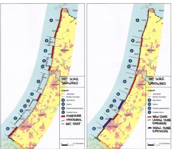
This case study presented in this report is based on the Holland coast and is spatially confined to central Holland. This area consists of the coasts of two dike ring areas (see glossary for an explanation of this phrase): dike ring 13 (Noord-Holland) and dike ring 14 (Zuid-Holland). The coastal defences within this area are mainly dunes and there are also some minor reaches protected by dikes (like the Hondsbossche Zeewering). This area is selected because it is densely populated and it accommodates a major part of the Dutch economy. It is evident that the protection of this area is very important from a socioeconomic point of view. The study area is sufficiently large to be able to evaluate measures for different spatial scales.
1.6.2 Temporal scope
The temporal scope of this study is ‘confined’ to a period of 200 years (as stated before). This period is selected because this seems to be the present interpretation of ‘long-term’ and due to increasing uncertainties it is impossible to apply an infinite timeframe. There are some indications available on the effects of climate change over this period. For longer periods, these predictions are lacking. For shorter periods, the timeframe of the evaluation would come close to the presently applied ‘short-term’ scope of 50 years.
Improved long-term coastal management as a result of a large-scale spatial perspective
1.6.3 Boundary conditions
Before and during the research, some assumptions will be made in order to determine the boundaries of this study within the previous stated temporal and spatial frames. These assumptions form the boundary conditions for the research and they are summarized below.
▪ For the central parts of Holland, the probability of flooding should be smaller than 1:100,000 per year. In order to do so, the coastal defences of this area should satisfy the design storm conditions that are based on extreme circumstances with a probability of occurrence of 1:10,000 per year [ENW, 2007]. The difference between those two frequencies comes from the fact that the coastal defences are still not allowed to fail when the design conditions occur, so their probability of failure should be even smaller than 1:10,000. According to the Directive on Dune Erosion (‘Leidraad Duinafslag’) the probability of failure of the coastal defences should (by definition) be 10 times smaller than the probability of occurrence of the design conditions [TAW, 1984].
▪ It is important to note that the probability of inundations from the rivers in the Netherlands is much larger than the probability of inundation from the sea. However, we only study coastal defences and do not account for potential inundations from the rivers.
▪ The calculation methods prescribed in the manuals for assessing coastal defences are the best methods presently available. Notwithstanding the uncertainties in these models (e.g. DUROS-plus), these results will be used to study the development of future weak links in the coastal defences.
▪ The coastal enhancement projects presently being planned and executed to improve the defences at the weak link locations are not included in the present situation of the coastal defences, nor in the autonomous development. They will be part of the basic alternative for coastal management representing the continuation of current practice.
▪ The coastal zone is defined as the area located between the depth contour where the seabed is located at 20 m below Amsterdam Ordnance Datum (=NAP) and the landward toe of the dunes. This toe (‘duinteen’) is found where the dunes end and the flat hinterland starts.
▪ The coastal zone is divided in several depth zones according to [Mulder e.a., 2006]:
- Landward of the 3 m + NAP (=Amsterdam Ordnance Datum) contour, we find dunes.
- Beaches are found between 3 m +NAP and 2 m –NAP.
- The zone between 2 m –NAP and 7 m –NAP is called the surfzone.
- The zone between 7 m –NAP and 13 m –NAP is the upper shoreface.
- The zone between 13 m –NAP and 20 m –NAP is the lower shoreface.
▪ Developments of the coast (both under water and at the beaches and the dunes) caused by
Improved long-term coastal management as a result of a large-scale spatial perspective
1.7
Outline of this study
The outline of this report is based on the research questions stated in section 1.5 of this introduction and a schematised overview of this outline is presented in Figure 7.
This study starts with an inventory of the long-term safety of the coastal defences in chapter 2. The final product of this chapter consists of three maps indicating the spatial distribution of the weak links that will emerge in the coastal defences over the next two centuries, according to each of the climate change scenarios. In order to preserve the present safety level of the coastal defences, long-term coastal management strategies are set-up in chapter 3. In this chapter, the study area is also divided according to different spatial scales. Chapter 4 contains the actual assessment of the proposed
strategies. At the end of this chapter, it will be clear whether and/or which new strategies might create better opportunities over the next two centuries than the continuation of present coastal management practice. In chapter 5, the results of this research are discussed from different perspectives. Finally, the answers on the research questions are summarized in chapter 6, which contains the conclusions and recommendations of this study.
Improved long-term coastal management as a result of a large-scale spatial perspective
2
Large-scale safety assessments of the coastal defences
This chapter starts with a review of long-term climate change expectations for the year 2200. Three climate change scenarios are derived from these expectations and are subsequently translated into safety scenarios for the Holland coast around the year 2200.
So new climate change scenarios are derived in the first section. The potential impact of sea level rise on the sand volumes contained in the coastal foundation is considered in the next section, together with the potential long-term effect of the continuation of the present coastal nourishment policy. The boundary conditions derived for the climate change scenarios are deviating from the conditions applied in previous studies (for example [Alkyon, 2001]). Therefore, new calculations are executed for assessing the impacts of these climate change scenarios on the safety of the coastal defences. The case that is studied, the Holland coast, brings its own (legally established) assessment framework for determining the safety of the coastal defences. This assessment framework and the methods for calculating the safety of dunes and dikes are shortly described in this chapter. Finally, the results of the newly executed safety assessments are presented in the last section.
It should be noted that this analysis is not meant to exactly state which reaches of the coastal defences will be insufficient at the end of this period. Instead, we are interested in a general analysis showing the percentage and spread of those locations where the coastal defences would fail in case of design storm conditions. This analysis serves to gather insight in the spatial extensiveness of the future weak links that may emerge in the coastal defences according to the different climate change scenarios.
2.1
Climate change effects
2.1.1 Review of knowledge on climate change and subsidence
In this study, we are interested in effects of the globally expected climate changes on sea levels during storm events. Processes of interest are thus: sea level rise and potential changes in wind strengths and directions. Next, parts of the Netherlands are facing subsidence, increasing the relative sea level rise.
Climate change
In the past century, the sea level along the Dutch coast rose with about 20 cm [KNMI, 2006]. However, it is generally accepted that climate change will speed up and the effects will increase. The
Intergovernmental Panel on Climate Change studies the worldwide climate change and the effects and developed several scenarios in its 2007 Fourth Assessment Report [IPCC, 2007]. The Dutch
meteorological institute (KNMI) studies these predicted world-wide changes and translates them to local effects: sea level rise in the eastern Atlantic and wind speeds in the North Sea area [KNMI, 2006].
The KNMI developed four climate change scenarios for the Netherlands for the period up to 2050 (Figure 8). Within these scenarios, predictions are made for changes in precipitation, wind speeds and for sea level rise. Predicted sea level rise depends on the sensitivity of the sea level to the expected climate change (Table 1). Within the context of this simple analysis the wind speed scenarios combined with the modelled wind direction changes do not give rise to strong changes in the occurrence and strength of North Sea surges [KNMI, 2006].
Improved long-term coastal management as a result of a large-scale spatial perspective
of other insights increasing the expectations again. The balance of these counteracting changes may stay more or less the same [Katsman & Van den Hurk, 2007].
A short review of scientific material available on the expected effects of climate change is included in appendix B.
Table 1: Sea level rise predictions for both the lower and higher climate change scenarios and for the potential differences in sea level sensitivity [KNMI, 2006].
Sea level
Figure 8: Climate change scenarios for the Netherlands up to 2050 according to the KNMI [KNMI, 2006].
Subsidence
While the sea level rises, the bottom subsides in the coastal areas of the Netherlands. In order to calculate relative sea level rise, this subsidence should be included.
There are two causes for subsidence in the Netherlands. The most important factor determining the subsidence of the coastal defences is the isostatic rebound of the earth crust. This concerns the vertical movement of Pleistocene sand beds and older bottom layers (see appendix D). This process causes a tilting of the Netherlands in seaward direction and induces a subsidence of about 7 to 8 cm per century of the north-western part of the Netherlands [Werkgroep Klimaatverandering en Bodemdaling, 1997] [TAW, 2002].
Next, there are some anthropogenic factors influencing subsidence. This could be caused by extractions of gas or other materials. These activities are not practiced in the coastal zone of the study area, except for a gas extraction location at Bergen. Lowering water level in polders also causes subsidence, due to the oxidation and compaction of the peat that runs dry. Although these processes form important land subsidence parameters in the hinterland of the coastal defences in the study area, this is not the case at the locations of the majority of the coastal defences [Van der Meulen e.a., 2007]. So subsidence of coastal defences (dunes and dikes) due to anthropogenic influences is negligible, except for the Hondsbossche and Pettemer sea defences (see appendix D for a review of several studies on this topic).
It is concluded that only land subsidence due to tectonic movement is of interest when considering the future safety of the coastal defences within the study area. The subsidence rates connected to this process are about 7 to 8 centimetres per century, so in 200 years one should account for a subsidence of about 15 cm. The only exceptions are the Hondsbossche and Pettemer sea defences (both dikes) where subsidence rates reach up to 20 cm per century [HHNK, 2008].
2.1.2 Aggregated climate change scenarios
Finally, the results of investigations into the effects of climate change and subsidence should be integrated into scenarios applicable in assessing and designing coastal defences. This is done before, for example for the boundary conditions presented in the manual for assessing sandy coasts of the Technical Advisory Committee on Water Defences [TAW, 2002]. These and other policy climate change scenarios are reviewed in appendix C.
Improved long-term coastal management as a result of a large-scale spatial perspective
Figure 9: Sand balances of the Dutch coast for the period 1965-1995, showing where net erosion and sedimentation occurred during this period [Min V&W, 2000].
the most extreme events that are possible. The final scenarios are presented in Table 2. Note that the sea level rise is relative, so 15 cm subsidence is included in these figures. Both the lower and the intermediate scenarios are derived from the minimum and maximum predicted values of the KNMI and they resemble the intermediate and high scenario of the TAW prescriptions very well. The higher scenario is derived from the observed geological maximum for possible sea level rise.
Table 2: Aggregated climate change scenarios to be applied in this study.
Scenarios for 2200 Sea level rise [m]
In these scenarios, it is supposed that the predicted sea level rise behaves linearly over time. This assumption is applied in many other studies too (see appendix B and C) and it is supposed to be the best possible method. However, it is far from sure whether this assumption resembles the future
developments, since sea level rise depends strongly on the uncertain melting and disintegration processes of the Greenland and Antarctic ice sheets [KNMI, 2006] [Katsman & Van den Hurk, 2007].
Next to the sea level rise, expectations on increasing storm surge levels and wave heights are included too. These changes are related to possible changes in wind climate. Even though the KNMI study [KNMI, 2006] shows that wind speeds and directions will not change significantly, the prescriptions of the Technical Advisory Committee on Water Defences on the increase of the storm surge level are included. The boundary conditions prescribed in the manual on assessing sandy coasts (see appendix C.1) present these changes for its maximum climate change scenario. These values are based on a 10% increase in wind speeds [Van de Graaff & Hoogewoning, 2002]. These assumptions are transferred to the upper scenarios since they are widely accepted yet and since one should look for extreme values within scenarios, even when there are large uncertainty ranges (for predictions of changing wind patterns). Moreover, experts showed that a little (4%) increase in wind speeds might cause a significant change in the storm surge levels and wave heights [Smale & Van der Biezen, 2007]. Therefore, it is important to be aware of this uncertainty and to incorporate its effects at least partially.
2.2
Continued nourishment policy
The present nourishment policy for the Dutch coast is quite important for the long-term development of the coastal zone, especially when rising sea levels will be faced. The impacts of this nourishment policy are described here, since it is supposed to be continued.
2.2.1 Coastal maintenance policy
Natural processes like aeolian sand transport and hydrodynamic action cause sedimentation and erosion to occur in the coastal zone. Once eroded from the Holland coast, sand is mainly transported by northward longshore currents towards the Wadden Sea where large amounts are deposited again. The figure shows the sand balances for the Dutch coast. Shallow (up to 8 m below
Amsterdam Ordnance Datum) and deep (up to 20 m below Amsterdam Ordnance Datum) waters are
Improved long-term coastal management as a result of a large-scale spatial perspective
On the long term, ongoing erosion would cause a recession of the beach and dunes. For example: one metre sea level rise would cause a coastline recession of about 40 metres [Van de Graaff &
Hoogewoning, 2002]. Next to sea level rise, human influences and natural processes (wind, water) are also moving sand, causing a net loss of sediment in the Dutch coastal system [Nederbragt, 2005]. In order to maintain the coastline, the national government decided in 1990 to apply a dynamic preservation policy based on sand nourishments. These nourishments should maintain the Basal Coastline (Basis Kustlijn, BKL in Dutch). This BKL is defined as the position of the coastline in 1990 and was derived from a linear trend over the past ten years. Wherever the Momentary Coastline (Momentane Kustlijn, MKL in Dutch) exceeds the Basal Coastline, beach or underwater nourishments are applied to refill the local shortage of sediment. The determination of the location of the Momentary Coastline is shown in Figure 10. The dune-toe is defined to be located at 3 m above Amsterdam Ordnance Datum and H is the distance between the dune toe and the mean low water level. When the cross-shore profile is know from a measurement (cross-shore profiles are gauged annually), the area A can be found by integrating the amount of sand available above the lower boundary of the calculation zone. Once H and A are known, the location of the Momentary Coastline can be calculated (B=A/2H).
Figure 10: Determination of the location of the Momentary Coastline. Wherever the MKL exceeds the Basal Coastline (the position of the MKL in 1990), sand nourishments are employed [Roelse, 2002].
Contrary to the maintenance of the coastal defences, being the responsibility of provinces and water boards, the national government (the Ministry of Transport, Public Works and Water Management) is responsible for the coastline maintenance policy. The amounts of sand supplied by nourishments between 1991 and 2005 are summarised in Figure 11. Within the period 1991-2000 about 6 million m3 of sand (about 20 m3/m) was supplied to the coast per year [Roelse, 2002]. Without these nourishments, a structural loss of sand would have occurred in the shallow parts of the coastal zone. These nourishments were meant to maintain the Basal Coastline (see Figure 4). From 2001 on, nourishment efforts are increased and about 12 million m3 of sand (40 m3/m) is supplied every year [Min V&W, 2000]. This increase was necessary to compensate for erosion at deep water and thus to maintain the coastal foundation (see Figure 4). Previously this loss rate was not compensated. Table 3 summarizes the averaged annual nourishments within the areas relevant for this study.
Table 3: Averaged annual nourishment efforts for reaches within the study area, derived from Figure 11.
Reach
Averaged annual nourishment [m3/m]
1991-2000 2001-2005
Noord-Holland 20 61
Rijnland 12 43
Improved long-term coastal management as a result of a large-scale spatial perspective
Figure 11: Total sand added by nourishments over the period 1991-2005 for all reaches along the Dutch coast [Nederbragt, 2005].
Next to aeolian and hydrodynamic processes, sea level rise also causes changes in the cross shore sand balance. Since the lower boundary of the coastal system is defined at 20 m below Amsterdam Ordnance Datum, the amount of sand in this system could be found in a strip reaching from the dunes down to a waterdepth of 20 m (Figure 12a). Part of this sand volume becomes located below the 20 m boundary due to sea level rise, and the sand reserves within the coastal foundation are decreasing. At the same time, sea level rise will cause a receding Momentary Coastline since part of the sand will be lost from the calculation zone (Figure 12b) [Mulder, 2000]. Both these losses should be compensated by sand nourishments. It should be noted that these losses are related to the calculation method, there is no physical loss of sand from the system.
Figure 12: Direct effects of sea level rise on the volume of sand in the coastal system (a) and on the location of the Momentary Coastline due to a changing amount of sand in the calculation zone (b) [Mulder, 2000].
Improved long-term coastal management as a result of a large-scale spatial perspective
sea level rise. This process will increase sand losses by longshore transport, which should also be compensated by sand nourishments [Mulder, 2000]. Figure 13 shows how much sand is needed for maintaining the Dutch coast (the BKL) for different sea level rise scenarios. However, Nederbragt [2005] states that much more sand may be required for future coastline maintenance: up to about 60 million m3/year in case of 85 cm sea level rise per century.
So the present policy of dynamic preservation of the coastline by sand nourishments is substantial for maintaining the Dutch coast at its current position. These nourishments are repeated every five years according to a long-range scheme for the entire coast [Roelse, 2002].
Figure 13: Required sand nourishment volumes to maintain the Dutch coast at different sea level rise scenarios. Uncertainty ranges are very large (+/- 50%!) [Min V&W, 2000].
2.2.2 Implications for autonomous coastal development
Since large amounts of sand will be added to the coastal system for maintaining the BKL, coastal cross- sections will change too. First, sand nourishments should cause the beaches and foreshores (including the surfzone and the shoreface) to keep up with sea level rise. Only then, the location of the Momentary Coastline will not exceed the Basal Coastline. At the same time, this development will prevent the dunes from structural erosion since the rising sea water level will not reach the dunefront.
Moreover, the dunes may grow by the ongoing landward sand transport by aeolian processes since there are large volumes of sand available at the seaside of the dunes. It is uncertain whether this will cause the dunes to increase in height or in width. However, dune configuration influences the amount of erosion during a critical storm event [Van der Burgh e.a., 2007]. And dune configuration also determines to a large extent the acceptable amount of erosion during a critical storm. Due to the uncertain future configuration, safety assessments of the Dutch coast always apply the present dune configuration and no assumptions are made on increasing heights or widths of the dunes. This is a conservative scenario.
At the same time, the rise of beach and foreshore levels (including the surfzone and the upper and lower shoreface) should be included in safety assessments. In this study, it is assumed that the present coastal maintenance policy will be continued, since ending it would result in structural erosion of the co

![Figure 6: The boundaries of the study area are determined by the boundaries of the dike ring areas 13 (north) and 14 (south) that are depicted at the left [Min V&W, 2007]](https://thumb-us.123doks.com/thumbv2/123dok_us/1022312.1126952/24.595.101.520.379.665/figure-boundaries-determined-boundaries-areas-north-south-depicted.webp)

![Table 1: Sea level rise predictions for both the lower and higher climate change scenarios and for the potential differences in sea level sensitivity [KNMI, 2006]](https://thumb-us.123doks.com/thumbv2/123dok_us/1022312.1126952/28.595.102.290.160.274/table-predictions-climate-change-scenarios-potential-differences-sensitivity.webp)