HIGH PRECISION GLOBAL POSITIONING SYSTEM DATA PROCESSING- VELOCITY VECTOR DETERMINATION FOR GEODYNAMIC APPLICATION
RABIEAHTUL ABU BAKAR
A thesis submitted in fulfilment of the requirements for the award of the degree of Masters of Science (Geomatic Engineering)
Faculty of Engineering and Science Geoinformation Universiti Teknologi Malaysia
To my lovely family and my beloved husband.
"Scientists still do not appear to understand sufficiently that all earth sciences must contribute evidence toward unveiling the state of our planet in earlier times, and that
the truth of the matter can only be reached by combing all this evidence. . . It is only by combing the information furnished by all the earth sciences that we can hope to
determine 'truth' here, that is to say, to find the picture that sets out all the known facts in the best arrangement and that therefore has the highest degree of probability. Further, we have to be prepared always for the possibility that each new discovery, no matter what science furnishes it, may modify the conclusions we draw."
iv
ACKNOWLEDGEMENT
In preparing this thesis, I was in contact with many people, researchers, academicians, and practitioners. They have contributed towards my understanding and thoughts. In particular, I wish to express my sincere appreciation to my supervisor, Professor Dr. Shahrum Ses, for his encouragement, patience and of all the funding throughout this study.
I am also very thankful to my friend as well as teacher Mr Soeb Nordin for his guidance to understanding the Bernese software from the setting up right to the processing end of it. I am also indebt to Mr Peirre Fredez from AIUB, though via the e-mails, for his prompt reply to my cry of help to out put problems encountered during the processing stages.
ABSTRACT
vi
ABSTRAK
TABLE OF CONTENTS
CHAPTER TITLE PAGE
TITLE PAGE i
DECLARATION ii
DEDICATION iii
ACKNOWLEDGEMENTS iv
ABSTRACT v
ABSTRAK vi
TABLE OF CONTENTS vii
LISTS OF TABLES xii
LISTS OF FIGURES xiii
LISTS OF ABBREVIATION xviii
1 INTRODUCTION
1.1 General Background 1
1.2 GPS and Its Ability to Predict the Plate
Deformation 4
1.3 Problem Statement 6
1.4 Research Objective 8
1.5 Research Scope 8
1.6 Research Contribution 9
1.7 Research Methodology 10
1.7.1 Hardware and Software Setup 11
viii
1.8 Literature Review 13
2 GLOBAL POSITIONING SYSTEM
2.1 Background of Global Positioning System
(GPS) 16
2.2 GPS Satellite Signals and its Application 19
2.2.1 Pseudo-Random Codes 20
2.2.2 The Navigation Message 21
2.2.3 Signal Processing 22
2.3 GPS Continuous Observation Centers 23 2.3.1 International GPS Service (IGS) 23
2.3.2 MASS 25
2.3.2.1 The MASS System 27
2.4 The GPS Observables 28
2.4.1 Pseudoranges 28
2.4.2 Pseudorange Observation Equation 29 2.4.2.1 Code Pseudorange
Observation Equation 29 2.4.2.2 Phase Pseudorange
Observation Equations 30 2.4.2 GPS Differencing Techniques 31 2.4.2.1 Single Difference 32 2.4.2.2 Double Differencing 32 2.4.2.3 Triple Differncing 33 2.4.3 Linear Phase Combination 34 2.4.3.1 Ionosphere-free 35 2.4.3.2 Geometry-free 36
2.4.3.3 Wide-Lane 36
2.5 GPS Errors Elimination and Biases
Reduction 38
2.5.1 Satellite Orbit 38
2.5.2 Keplerian Orbit 41
2.5.3 Earth Rotation Parameters (EOP) 43 2.5.4 Antenna Phase Center
Variations (PCV) 44
2.5.5 Receiver Clock 45
2.5.6 Ionosphere 46
2.5.7 Troposhere 47
2.5.8 Tide and Loading 50
2.5.8.1 Ocean Loading 50
2.5.8.2 Ocean Tide 51
2.5.8.3 Atmosphere Loading 52
2.6 Ambiguity Resolution 52
2.6.1 Directly Resolving Ambiguities on
Short Baselines 54
2.6.2 The Quasi-Ionosphere-Free (QIF) Ambiguity Resolution
Strategy 54
2.7 ITRF 55
2.8 Summary 57
3 GPS for Geodynamic Studies
3.1 Introduction to Geodynamic 58 3.2 Evolution of the Plate Tectonic Theory 58
3.2.1 Pangea 59
3.3 Continental Drift 60
3.3.1 Sea-Floor Spreading 61
x
3.4.1 Divergent Boundaries 65 3.4.2 Convergent Boundaries 65
3.4.2.1 Oceanic-oceanic
convergence 66
3.4.2.2 Oceanic-continental
convergence 66
3.4.2.3 Continental-continental
convergence 67
3.4.3 Transform Boundaries 67
3.5 The “Ring of Fire” 67
3.6 Plate Tectonic and GPS 69
3.7 Malaysia 70
3.8 Site Description 71
3.9 Previous Regional Campaigns 72
3.9.1 Geodyssea 72
3.9.2 APRGP 73
3.9.3 GDM2000 73
3.10 Velocity 74
3.10.1 Velocity Frame 74
3.10.2 Absolute 74
3.10.3 Relative 74
3.10.4 Absolute-Free Velocities 75 3.10.5 Absolute-Fix Velocities 75 3.10.6 Relative-Free Velocities 75 3.10.7 Relative-Fix Velocities 75
3.11 Summary 76
4 DATA ACQUISITION AND PROCESSING
4.1 Introduction 77
4.2 Data Acquisition 77
4.3.1 TEQC 78
4.4 Bernese Version 4.2 79
4.4.1 RINEX Files 79
4.4.2 Ocean Loading Files 80
4.4.3 Velocity Files 80
4.5 Data Processing 81
4.5.1 RXOBV3 (Transfer Part) 82
4.5.2 PRETAB & ORBGEN 83
4.5.3 CODSPP 86
4.5.4 SNGDIF 88
4.5.5 MAUPRP 88
4.6 Adjustment- Parameter Estimation 90 4.6.1 Parameter Estimation GPSEST1 90
4.6.2 RESRMS 92
4.6.3 SEROBVS 92
4.6.4 GPSEST II 92
4.6.5. GPSEST III 93
4.6.6 GPSEST IV 94
4.6.7 Troposphere Estimation 95 4.6.8 Ionosphere Modelling 96 4.6.9 Ocean Loading Parameters 96 4.6.10 Ambiguity Resolution 96
4.6.11 Weekly Solution 96
4.6.12 Helmert Transformation 97 4.6.13 Generating Velocity 98
4.7 Summary 98
5 RESULTS AND ASSESSMENT
5.1 Outcome and Reliability 99
5.2 Helmert Transformation 104
xii
5.4 Station Velocity 106
5.5 Residual Graphs 107
6 CONCLUSIONS AND RECOMMENDATIONS
6.1 Summary 109
6.2 Other Method of Detecting Earth
Deformation 109
6.3 Recommendations 110
LISTS OF TABLES
TABLE NO. TITLE PAGE
2.1 Components of the satellite signal 19
2.2 Linear combinations (LCs) of the L1 and L2
observables used in Bernese 38
2.3 Errors in baseline components due to orbit errors 40
2.4 Estimated quality orbits in 2000 41
2.5 Pertubing accelerations acting on a GPS satellite 43
xiv
LISTS OF FIGURES
FIGURE NO. TITLE PAGE
1.1 Earth’s Core 1
1.2 Continental Plates of the Earth 2
1.3 The Ring of Fire 3
1.4 Fault lines in the South-East Asian Region 4 1.5 IGS Sites selected to tie the MASS to ITRF 5
1.6 MASS sites in East and West Malaysia 6
1.7 GPS Processing Diagram 10
1.8 Process Control Script flow chart 12
2.1 GPS orbits (Earth and orbital planes) 17
2.2 GPS Block II satellite and satellite-fixed
coordinate System 19
2.3 Biphase modulation of the GPS signal 20
2.4 The Distribution of the IGS stations 24
2.5 Distribution of the MASS locations in Malaysia 26 2.6 Geodesy Data Processing Centre Configuration
in Kuala Lumpur 26
2.7 Remote Base Station set-up 27
2.8 The set of orbital elements 42
2.9 GPS Signals with Ionospheric Delays 46
2.10 Tilting of the ‘Tropospheric’ Zenith by the Angle β 50
2.11 The ocean tides for harmonics M2 51
2.12 The IGS stations are distributed all around the globe 57
3.1 PANGAEA 59
3.2 Holmes’ model of convection currents 60
3.4 Sea Floor Spreading 62
3.5 The Tectonic Plate Boundaries 63
3.6 The ‘Ring of Fire’ 68
3.7 Malaysia and Its Plate Location 69
3.8 Malaysia 71
4.1 Bernese Concise Processing Diagram 81
4.2 Transfer Menu 82
4.3 Orbit Menu 83
4.4 Standard Orbit Generation Menu 84
4.5 Results for ORBGEN Program 85
4.6 Results for ORBGEN Program 85
4.7 Input Menu for CODSPP 86
4.8 Determining the Atmosphere Models 86
4.9 Result from CODSPP Program 87
4.10 SNGDIFF program Menu 4.3 88
4.11 MAUPRP Program Menu 4.4.2 89
4.12 MAUPRP Input Menu 4.4.2-1 89
4.13 Diagram of the Daily Adjustment of the
Bernese Processing 90
4.14 GPSEST I Menu 4.5 91
4.15 Output files for GPSEST I 91
4.16 Menu 4.5-2.4 GPSEST IV Program 94
4.17 Menu 4.5-2.4B 95
5.1 Ambiguity Resolution Percentage of the
first day of year 2001 100
5.2 RMS of Residuals of Observation 101
5.3 Daily RMS 102
5.4 Weekly Residual RMS GPS Week 1046 102
5.5 Formal Accuracy of the Coordinate week 1046 103
5.6 Overall Weekly Residual RMS 104
5.7 Velocity for the year 2000-2002 for the first months 106
xvi
LISTS OF ABBREVIATION
AIUB - Astronomical Institute of the University of Bern
AR - Ambiguity Resolution
ARP - Antenna Reference Point
AS - Anti-Spoofing
BKG - Federal Agency of Cartography and Geodesy CBIS - Centre Bureau Information System
CGGS - Centre for Geodynamics and Geodetic Study CIO - Conventional International Origin
CODE - Centre for Orbit Determination in Europe
CPC - Central Processing Center
DS - Data Screening
DSMM - Department of Survey and Mapping, Malaysian
ERP - Earth Rotation Parameter
EUREF - European Reference Frame
GDPC - Geodesy Data Processing Center GIPSY - GPS-Inferred Positioning System GLOSS - Global Sea Level Observing System
GMT - Graphical Mapping Tools
GPS - Global Positioning System
GPSEST - Program used in Bernese for Parameter Estimation IAG - International Association of Geodesy
IAU - International Astronomical Union IERS - International Earth Rotation Service IGN - Institute Geographical National
IGS - International GPS Service
IUGG - International Union of Geodesy and Geophysics
JPL - Jet Propulsion Laboratory
JUPEM - Malaysia Language for DSMM
LLR Long Laser Ranging
LOD - Length Of Day
MASS - Malaysian Active GPS System
MAUPRP - Program used in Bernese for Phase Check MSRF - Malaysian Spatial Reference Frame
N - Number for independent baseline
NASA - National Aeronautic and Space Administration NAVSTAR GPS - NAVigation Satellite Timing and Ranging GPS
NGS - National Geodetic Survey
PRN - Pseudo-Range Number
RINEX - Receiver Independent Exchange
RTK - Real Time Kinematic
RMS - Root Mean Square
SA - Selective Availability
SINEX - Solution Independent Exchange SIO - Scripps Institution of Oceanography
SLR - Satellite Laser Ranging
SNGDIF - Program used in Bernese for Single Differences
SVN - Satellite Vehicle Number
CHAPTER 1
INTRODUCTION
1.1 General Background
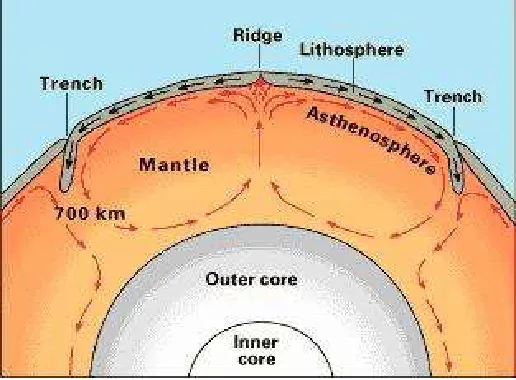
Sun, Moon and Planets are continuously in motion, each on its own orbit in a continuous manner, of which, theoretically started from the birth of the universe between 10 to 20 billion years ago during the primeval fireball also known as the Big Bang (Hawkings, 1993). They influence each other through their very existence, exerting gravitational forces between two bodies according to Newton’s law of gravitation. Focusing on the moving bodies that co-exist on earth such as; the ocean tides, earth tides, plate tectonics, and dynamics of the earth mantle are some of the movements that we take for granted in our daily lives until nature takes it toll.
According to the theory of plate tectonics derived during the 1960’s evolved from the theory of continental drift by Alfred Wegener in 1912, said that the Earth's outer layer, or crust, consists of a series of plates made up of lithospheric material, which floats on the denser upper fluid asthenosphere mantle within the Earth's interior. These movements may cause the plates to convergent, divergent forming trenches and ridges or even having lateral movements that cause an earthquake. The earth consists of 12 major plates, the Eurasian plate, Indian plate, Philippine plate, Pacific plate, Nazca plate, Caribbean plate, North American plate, South American plate, African plate, Arabian plate, Australian plate and the Antarctic plate. The edges of these plates form the (plate margin) fault lines to where the occurrences of earthquakes and volcanic activities are profound.
Figure 1.2: Continental Plates of the Earth
In Malaysia, these movements are taken for granted since geographically the peninsular is located on one command plate, the Eurasian plate. The fault lines however, meanders not very far from the edges of the peninsular and passes through the Indonesian Javanese Island. Krakatau is situated between Sumatra and Java in Eurasian plate where
3
Indonesia, and forms part of the volcanic arc of a subduction zone in the Indo-Australian Plate, moves towards the northeast (Forde, 1994).
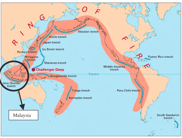
Figure 1.3: The Ring of Fire
The Sunda Islands allocated in the western part of Indonesia consists of Sumatra, Java, Kalimantan and Sulawesi. They also form a string of volcanic islands extending from the Bay of Bengal forming an arc facing the Indian Ocean toward Australia curving back to the north and west, constituting what is called an island arc in geology. The Philippine Plate is located on the northeast from the edge of the Eurasian plate. Another string of islands extends from the Mollucas to the north into the Philippine islands. This island arc, often called the Sunda arc, encloses to the north the Malay Peninsula, the great island of Kalimantan (Borneo) and four armed islands of Sulawesi (Celebes), with a string of small volcanic islands extending from the north eastern arm of Sulawesi to the Philippines. The above description all falls into an area also known as the "Ring of Fire" which is an arc stretching from New Zealand, along the eastern edge of Asia, north across the Aleutian Islands of Alaska, and south along the coast of North and South America. It is composed over 75% of the world's active and dormant volcanoes located at the borders of the Pacific Plate and other tectonic plates.
Figure 1.4: Fault lines in the South-East Asian Region.
Earthquakes occurrences along these lines do influences and disrupt the stability of buildings and structures in Malaysia. For instance, a powerful earthquake rocked the Indonesian island of Sumatra according to the United States Geological Survey (USGS) on the 4th of June 2000 recorded the quake at 7.9 on the Richter scale
and it was felt throughout KL, though no massive destruction occurred. The latest occurrence is the oceanic earthquake on December 2004 carrying a magnitude of 8.9 on the Richter scale and brought with it the Tsunami one of the biggest in the century. The seawater displacement result from the plate subduction killed over hundreds of thousands across Asia.
1.2 GPS and Its Ability to Predict the Plate Deformation
A fiducial network incorporates VLBI, SLR, and GPS systems which are operated on a permanent, continuous basis, and which will provide reference geodetic data to which regional studies occupying many sites on a short-term, temporary basis can anchor. GPS, VLBI, SLR, and LLR technology can be integrated to monitor plate motion and deformation, to monitor Earth rotation, and to
Fault lines
5
define and maintain a terrestrial reference frame. Permanent regional and local monitoring networks deployed across tectonically active regions to measure and analyze the motion and deformation over a broad range of spatial and temporal scales.
Figure1.5: IGS Sites selected to tie the MASS to ITRF
The DoD of America adopted global Positioning System (GPS) and had launched their first satellite for the purpose of military was on the 18th February
Figure1.6: MASS sites in East and West Malaysia
Currently, there are 18 permanent GPS stations around Malaysia as shown in figure 1.6, operating on a 24 hours basis called the MASS. The reconnaissances of the stations were carried out in the late 1997 as proposed after the GEODYSSEA second campaign by the DSSM (Majid et al., 1998). Moreover, with the realization of the ITRF, Malaysia can now be mapped onto the globe more accurately. Basically, the ITRF frame is a conventional frame created under international sponsorship in order to satisfy the accuracy requirements of various modern space techniques. Furthermore, the origin, coordinate axes orientation, and scale of the ITRF frame are implicitly defined by the coordinates adopted for the worldwide tracking GPS sites involved in each IERS yearly global solution (Soler et al., 1999). Thus, the IGS sites in ITRF frame will be very useful for those scientifically advancing countries to fix their region onto the same frame as the rest of the world.
1.3 Problem Statement
7
between epochs of different time line can be roughly assumed to be relatively constant without any significant differences.
Presumably Malaysia is out danger, but we take it for granted though realizing that it lies within the buffer of the ‘Ring of Fire’. It is fortunate, that Malaysia do not lie on a fault line, however, Malaysia is situated near several active faults lines. Therefore, monitoring of the plate motion is essential for predicting the changing plate motion.
The world changes in more then one way i.e. the eccentricity of the earth increases over time making the earth more elliptical (Pine, 1989). Monitoring the trend of the unpredictability might help us take some precautionary actions before the occurrence of natural disaster, to identify changing fault lines or new born faults. Moreover, since crustal movements but could be patterned if monitored over several of years. A long time series of measurements, of several years or more, are required in order to obtain accurate site velocity estimates (Mao et al. 1999).
Learning from the 2004 Tsunami that hit Aceh, India and reflected to a small area in the Upper West Coast of Malaysia proofs that geodynamic exploration should be escalated and this study is a form of realization to this vulnerability.
This study will only look upon three years of MASS data from which most of the data were available simultaneously processed with 3 consecutive years of selected IGS. Since this movement is not evident for short observation or even observation of 1-year time span, therefore, a longer period of observation is needed to identify this movement. In this research the author will output the relative MASS stations coordinates and velocity estimates in ITRF2000.
However, in this study Bernese high precision GPS processing software version 4.2 was utilised to determine the final solution for the relative MASS station coordinates, hence to estimate the relative velocity of each station to the global velocity (NUVEL1A). Screening cycle slips, using linear combination of phase observables to estimate the site specific atmospheric parameters, and resolving ambiguities will give a reliable coordinate of lesser than 10mm in horizontal and 15mm in vertical in predefined ITRF2000 frame.
1.4 Research Objectives
Referring to the applicability of GPS to geodetic and geodynamic studies the objectives of this study are as follows:
1. To produce a high precision GPS solution of the Malaysian Network.
2. To derive accurate position Time Series leading to accurate velocity determination.
3. To make a geodynamic interpretation from the GPS analysis using the derived velocity.
1.5 Research Scope
9
These weekly solutions were tied with reference to the mid of each respective week. Final coordinates for each MASS stations were acquired and their residuals plotted. These residual plots were over a period of three consecutive years, thus, resulting in a time series. From these time series, graphs plotted were analysed to determine the accuracy of the relative velocity of each station.
The weekly solutions were stacked together to produce the velocity estimation of each station. The mean from this stations velocity is the result of the overall movement of the peninsular and East Malaysia with respect to the Indo-Eurasian Plate. Thus, geodynamic interpretation can be analysed from the derived velocity.
1.6 Research Contribution
Generally, this study will be of benefit for DSMM towards a dissertation of handling of the Bernese GPS software version 4.2 and the processing strategy to achieve accurate MASS final coordinate. Conversely, generating relative velocity estimates for the MASS stations and give a geophysical study of the crustal motion achieved from the GPS measurements.
MASS station coordinates are refined which was previously computed with reference to ITRF 97 over a period of 1 and a half year are process over an even longer period to derive to an up to date coordinate with reference to the ITRF 2000 frame towards 1ppm in precision. 5mm level of accuracy within a 95% confidence interval for the horizontal components and vertical component of no more than three times the ratio to the horizontal component of the MASS absolute coordinate is to be achievable.
Estimating the velocity of each MASS station and determine the accuracy of this velocity generated. These velocity can later be use to interpret geodynamic movements of the plates.
1.7 Research Methodology
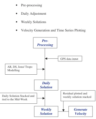
There are 4 major phases in processing, before we can achieve the end products of both the estimated relative velocity and the time series of each MASS station coordinates. The 4 phases are as followings:
• Pre-processing
• Daily Adjustment
• Weekly Solutions
• Velocity Generation and Time Series Plotting
Figure 1.7: GPS Processing Diagram
Pre-Processing
Daily Solution
GPS data input
AR, DS, Iono/ Tropo Modelling
Weekly
Solution Generate Velocity
Daily Solution Stacked and tied to the Mid-Week
11
Methodology of this study consist mainly preparation and processing before the final output can be achieved. Each of these steps are crucial and it is essential for them to be carried out well before proceeding to the next phase, since they are interrelated and the accuracy of the results very much depends on the reliability of the former stages. However, chapter four will explain this process in greater length.
1.7.1 Hardware and Software Set-up
GPS data will be processed using the Bernese version 4.2. Specification of the hardware compatible for mounting the Bernese environment and to manage the 3 years of data will be rather immense. A large hard disk space is recommended eg. the power station that is utilized in this study have two 80GByte hard disk one as the processing platform and the other for backing up the data and results. Anyway, a large space will be needed to store the GPS data.
Most importantly, a large space hard disk will make it possible to process the GPS data efficiently and at ease especially with the ability of the BPE. Then, even months of continuous data can be processed within a short time span compared to other lower graded workstation. However, minimal computer is not stated regardless utilizing 48MB of RAM and old Intel 386 processor the Bernese software is still capable to run. For safety purposes and maintenance of hardware a UPS system will be very useful and overnight processing.
Only then can one set up the bernese environment on root later then on the main user home utilising bernese. More then one user in a group specified to use the bernese environment could use bernese simultaneously. However, it is preferable that only the main user has all the unrestricted access and managers all the files, folders of bernese as well as the RHL8.0 system. Fortran compiler G77 and source F77 are use for these and BPE demo will be install automatically then after editing the remote hosts and remote bash profile is needed for bernese to run properly. It is mandatory to recompile the software after installation for it to link the directories and folders.
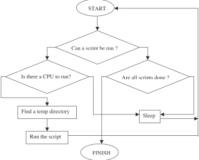
For BPE to run the processing control script (PCS) are edited. Each program to be run for the GPS processing edited to the preference of the user. Strategy setting for GPS processing starts here. Then each program run tested. BPE is well suited to process data from permanent GPS arrays in a completely automatic and efficient way.
Figure 1.8: Process Control Script flow chart. Basically how the BPE works. START
FINISH Can a script be run ?
Are all scripts done ? Is there a CPU to run?
Sleep Find a temp directory
13
Bernese GPS software itself is created to cater for rapid processing of small-size single and dual frequency surveys and permanent network processing. It can resolve ambiguity on long baselines of up to 2000km using final orbits and taking into accounts of other parameters to be modelled or estimated.
1.7.2 Data Preparation
The hourly MASS data was acquired from DSMM headquarters for 1st January 2000 up to 31st December 2002. Most of the data was already archived in a 24hours daily compact rinex zip form. These data were then scanned through teqc for quality and checking for errors in the header. Essentially, the monument name, dome number, antenna and receiver pair type, and the antenna height. Data were decimated to 30seconds interval and kept in the RAW folder in the campaign directory. Data with too many missing observation can be predicted to cause inaccuracy in the processing later.
IGS stations scattered around the Malaysian parameters were selected to its availability and to the period of establishment of the station which will determine the stability of the data collected. These data are usually readily ‘teqc’ed. However, this does not mean that they are free from causing problems to the results later on. Thus, the data quantity has to be checked before processing can even take place. Low quality and inadequate data quantity of lesser than 12 hours observation should be identified and listed out.
1.8 Literature Review
applications for demanding high accuracy, reliability and high productivity (Hugentobler et. al., 2001). It is also suitable for permanent GPS stations processing on long baseline (2000km) ambiguity resolution for post-processing (Beutler et al, 1996).
Ambiguity resolutions are recommended in baseline mode, whereby each baseline are processed separately then introducing the resolved ambiguities as known quantities into the subsequent session processing (Hugentobler et. al., 2001). Over long baselines of over thousands of kilometres the processing strategy (proposed are as follows:
• Use of IGS precise orbit and ERP parameters
• Processing using 24 hours sessions of 15/30 second data
• Elevation cut-off angle 15 degrees and with dependent satellite elevation-weighting COS Z.
• Phase center offset are referenced to antenna phase center variations (PCV) Phasigs-01. table
• Single difference using OBMAX / SHORTEST test for the better dependent on station location and data availability
• Zenith delay parameters at least once every two hours and residual markings.
• Estimated troposphere parameters
• L3 linear combination of ionosphere-free float solution
• Quasi-Ionosphere Free (QIF) ambiguity resolution strategy
• Daily solutions computed for normal equations and analysis of precision
15
• Final solution staking of all (weekly/daily) normal equations and constrained to the fudicial stations final coordinates in the respective ITRF reference frame
Usually, the achievable precision for the final coordinates will fall within 2 to 8mm in horizontal position and 10 to 20 mm in vertical position, and about 1-2x10⁻⁸
(or 1 to 2 cm in thousand kilometer baseline). The absolute coordinate accuracy in the ITRF frame could be approximate or at least better than 3cm (Becker et al., 1998; Alves Costa et al., 2001; Li and Cheng et al., 2001; Rozsa, 2002)
According to Borkowski et al. (2002) the EPN time series analysis station are located more than 700km from the local LGN network. Few of the European network station selected to tie to the local network are located close to the research area thus possesses significantly worse quality parameters. Selections of the reference stations were made from the mean trend congruency analysis of the EPN stations coordinate time series. Relative velocities between selected EPN stations evaluated using different approaches (time series analysis, ITRF2000 velocities, NUVEL1A-NNR velocities)