SCENARIO-BASED SPATIAL MODELLING FOR LAND USE PLANNING AND EVALUATION
Ahmad Nazri Muhamad Ludin Ahris Yaakup
Department of Urban and Regional Planning Faculty of Built Environment
University of Technology Malaysia Email: b-anazri@utm.my and b-haris@utm.my
Abstract
The understanding of the urban system that promotes urban growth is crucial for the purpose of policy making, formulating development strategies as well as development plans preparation. Urbanization contributes many advantages in terms of economics, but if uncontrolled, would create negative consequences to the physical, social and natural environment. Since planning is a future-oriented activity and necessitates forecast, the urban model is one of the techniques that assist planners to implement their work systematically. Geographic Information System (GIS) has provided an alternative tool in spatial modelling which contribute to much clearer understanding of the real planning problems as well as prescriptive planning scenarios to enhance the quality of urban planning and management. GIS notably provide a strong platform for decision makers in its role as the main component in Planning Support System (PSS) and Decision Support System (DSS). This paper will discuss the development and application of a PSS and DSS in the generation and selection of alternatives. A case study in Gombak District, located in the Klang Valley which is a rapidly growing region in Malaysia, are used to generate land use planning scenarios based on specified planning policies. The planning scenarios are then evaluated by using a Decision Support Software Definite, to improve the quality of decision making through the selection of better alternatives.
Keywords: Land Use Planning, Geographical Information System,
Planning Support Systems and Decision Support Systems.
1.0 INTRODUCTION
The development of Planning Support System (PSS) and Decision Support System (DSS) in a GIS environment has been proven to be an ideal technological-based tool to fulfil the requirements of planning. With respect to the planning process and the use of appropriate system models, GIS alone hardly provides all the functions that planning requires. As Webster (1993) argued that the relationship between GIS and planning activity can be viewed from various perspectives, which include effort to relate GIS and information system more extensively within the context of information requirements for planning. Thus, GIS need to be integrated with other system to fulfil the requirement of planning.
This paper attempts to explain the use of a PSS and DSS in the development plans implementation and monitoring of urban development, as it is capable to optimise development strategically in planning. Land use scenarios are generated in a PSS framework using the What-if software, while the DSS in a Definite environment is used to select for best development alternative.
2.0 PLANNING SUPPORT SYSTEM AND SPATIAL DECISION SUPPORT SYSTEM
From both technical and functional viewpoints, it has been commonly accepted that a PSS should be built on the basis of GIS technology (Klosterman, 1994). GIS is a part of the Planning Support Systems (PSS), which can support decision-making and urban problem solving to a significant extent. However, planners will have to adapt with the existing GIS tools to meet their needs. A combination of sophisticated GIS macro commands and traditional programming language can be used to develop spatial analysis analytical models closely linked to a full-featured GIS toolkits (Klosterman, 2001). The PSS which is a combination of GIS data, urban model and presentation technique using computer for planning support has been increasingly in use to improved planning decisions. PSS structure and information access make possible to visualize the world in
‘reality’ and support the capabilities for analyzing, prediction and making planning decisions (Brail and Klosterman, 2001). In addition, the evolvement of information technology towards PSS means that the utilization of GIS is much more significant and satisfy the need of planning particularly in spatial modelling such as urban models. GIS will serve as a display and communicative instrument, producing maps and charts that describe past and present conditions and model outputs that suggest alternative futures, which support decision making. Generally, PSS involved urban database and usage of simulation database model in urban planning that can interact with the user through a dialog module (Figure 1).
Urban Database
(DBMS)
Simulation Database Model In
Urban Planning
Dialog Module
Planner
Figure 1: General Concept of Planning Support System.
Source: Yaakup et al., 2004
Decision support system (DSS) was first developed for business application and later evolved into spatial decision support systems (SDSS) and applied to various applications including urban planning monitoring and management. SDSS allows the decision making process to be iterative, integrative and participative. The process is iterative because a set of alternative solutions is generated for decision makers to evaluate, participative because the decision makers plays an active role in defining the problem, and integrative because value judgements that affect the final outcome are made base on expert knowledge that must be integrated in the models (Densham, 1997). The model created in this paper will examine the integration of both the PSS and DSS application in a GIS environment and embraced an integrated spatial planning approach as an alternative for decision makers.
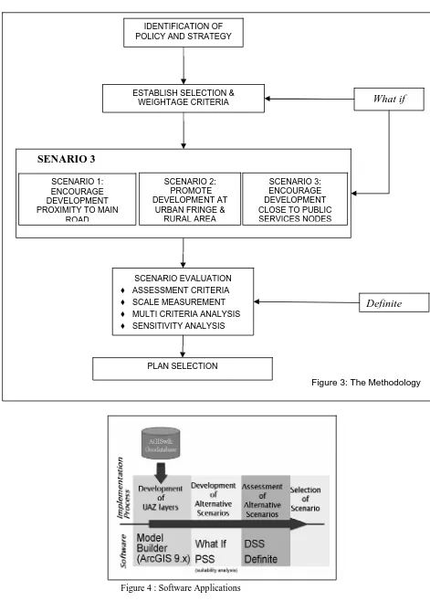
3.0 METHODOLOGY
What if? PSS Software is used in this study to generate development scenario alternatives that serve as a basis for the formulation of more rational and effective development policies and strategies. While Decision Support Software DEFINITE is used to select development
alternatives based on a specified procedure. The development scenario is developed using
Klosterman (2001) What If collaborative planning support system which essentially involves three steps: (1) formulating land suitability maps using spatial data sets, (2) predicting future land use requirement based upon projected population, and (3) forecasting patterns of change using land use controls and growth pattern value. What if is an explicitly policy-oriented planning tool that can be used to determine what would happen if certain policy choices are made and assumptions concerning the future are correct (Klosterman, 2001).
The first steps involve identification of policy and strategy to be used as guideline and direction of the study in achieving the desired output. For this purpose, the study takes into consideration policies that are being proposed and adopted by the planning authority, i.e. from the State Structure Plan and the Klang Valley Perspective Plan (PELAWI). The study will generate three development scenarios based on two sectoral strategies taken from the PELAWI while the other from the State Structure Plan. The development scenarios are:
a. Scenario 1: Based on continued growth strategy by encouraging development
particularly in proximity to main road (PELAWI).
b. Scenario 2: To promote development in urban fringe and rural area (State Structure
Plan).
c. Scenario 3: To encourage development in area closed to public services and
transportation nodes such as LRT transit zone, new industrial area and public transportation stations (PELAWI).
Secondly, data sets from AGISwlk, a GIS project for Klang Valley region, database are used to create Uniform Analysis Zone (UAZ) based on predetermined selection factors. UAZs are GIS generated polygons, which are homogeneous in all aspects considered in the model (Figure 2). For instance, all points within a UAZ have the same slope, are located in the same municipality, are within the same distance of an existing or proposed highway, and so on (Klosterman, 2001).
The third steps involves the analysis and modelling stage prior to creating development scenarios, which also include the process of creating Uniform Analysis Zone (UAZ), designing project file and conducting suitability analysis. The
process of creating UAZ layer involved combining of selective GIS data layers. Creating UAZ layers are simplified through the use Modelbuilder, an ArcGIS 9.x component. The GIS functions involved in the process are the overlay function, classification and measurement. Designing the project file is most important because it influence the suitability analysis and affects the resulting output. The suitability analysis involves three basic steps which are: (1) selecting the suitability factors, (2) specifying factor weights, and (3) specifying factor ratings. In this study, a mathematical formula was applied for all the factors taken into consideration in generating the development scenarios.
Location Factor Model Flowchart
UAZ Data Layer
Figure 2: Generating UAZ Data Layer
assessment, (3) multi criteria analysis, and (4) sensitivity analysis. The methodology of the study are summarised in Figure 3, while the related software used are shown in Figure 4.
Figure 4 : Software Applications
Figure 3: The Methodology IDENTIFICATION OF
POLICY AND STRATEGY
ESTABLISH SELECTION & WEIGHTAGE CRITERIA
SCENARIO EVALUATION
♦ ASSESSMENT CRITERIA
♦ SCALE MEASUREMENT
♦ MULTI CRITERIA ANALYSIS
♦ SENSITIVITY ANALYSIS
What if
PLAN SELECTION
Definite
SENARIO 3
SCENARIO 1: ENCOURAGE DEVELOPMENT PROXIMITY TO MAIN
ROAD
SCENARIO 2: SCENARIO 3:
ENCOURAGE DEVELOPMENT CLOSE TO PUBLIC SERVICES NODES PROMOTE
DEVELOPMENT AT URBAN FRINGE &
4.0 RESULTS
All the scenarios generated have shown positive results in relation to their respective guiding policies and strategies which have been determined based on the PELAWI and State Structure Plan. The generated plan are categorize into three scenarios, i.e. (1) area that are not suitable to be develop, (2) area that can not be change in term of use, (3) area that have the potential/ suitable to be develop. The area that are suitable to be developed are further categorised into low, moderate and moderately high. The maps that are generated from the scenario development process are shown in Figure 5. Since the application of What if procedures is only limited to generating map scenarios, the results were further examined to select the possible best alternatives from the scenarios.
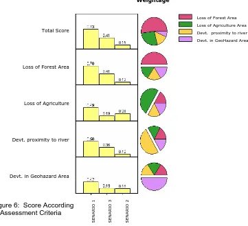
The selection from the scenarios is evaluated using the Definite 2.0 software. The evaluation process is important in term of the planning process where decisions need to be made about suitable development that takes into consideration various aspects such as environmental impacts and risk. The evaluation process was done through quantitative assessment which involves multi criteria analysis where weighted summation method and interval standardization for ranking of alternatives were carried out. Sensitivity analysis was then conducted to analyse the sensitivity of ranking through assessment of the score and weight uncertainty in defining the priority of the objectives which defined each scenarios that have been generated.
Weightage
Loss of Forest Area
Loss of Agriculture
Devt. proximity to river
Devt. in Geohazard Area
SEN
A
R
IO
1
SEN
A
R
IO
3
SEN
A
R
IO
2
Total Score
Loss of Forest Area Loss of Agriculture Area Devt. proximity to river Devt. in GeoHazard Area
Figure 6: Score According to Assessment Criteria
SENARIO FAKTOR LOKASI SENARIO 1 DAERAH GOMBAK
-No. Pelan : 3.11
Tajuk Utama: Tajuk Kecil : Kawasan : Blok :
Skala
S
B T
Figure 5: The Generated Scenarios
AGISwlk
AGISwlk
APLIKASI SISTEM MAKLUMAT GEOGRAFI WILAYAH LEMBAH KLANG
PETUNJUK
Kementerian Wilayah Persekutuan
PAHANG
W I L A Y A H
W I L A Y A H
P E R S E K U T U A N
P E R S E K U T U A N
H U L U L A N G A T
H U L U L A N G A T
P E T A L I N G J A Y A
P E T A L I N G J A Y A
Kuang AMPANG RAWANG SELAYANG Arang Batu Gombak Setia
Ampang Hulu Klang
00.51 2 3 4 5 Kilomete 1:245,000
SENARIO 1
rSempadan Negeri Sempadan Daerah Senario 1 Kategori Kesesuaian Tidak Dibangunkan Tidak Ditukarguna Rendah (0-24) Sederhana Rendah (25-48) Sederhana (49-72) Sederhana Tinggi (73-96)
SENARIO FAKTOR LOKASI SENARIO 2 DAERAH GOMBAK
-No. Pelan : 3.12
Tajuk Utama: Tajuk Kecil : Kawasan : Blok : Skala S B T U AGISwlk AGISwlk
APLIKASI SISTEM MAKLUMAT GEOGRAFI WILAYAH LEMBAH KLANG
PETUNJUK
Kementerian Wilayah Persekutuan
PAHANG
W I L A Y A H
W I L A Y A H
P E R S E K U T U A N
P E R S E K U T U A N
H U L U L A N G A T
H U L U L A N G A T
P E T A L I N G J A Y A
P E T A L I N G J A Y A
Kuang AMPANG RAWANG SELAYANG Arang Batu Gombak Setia
Ampang Hulu Klang
00.51 2 3 4 5 Kilomete 1:245,000
SENARIO 2
rSempadan Negeri Sempadan Daerah Senario 2 Kategori Kesesuaian Tidak Dibangunkan Tidak Ditukarguna Sederhana Rendah (16-30) Sederhana (31-45) Sederhana Tinggi (46-60)
SENARIO FAKTOR LOKASI SENARIO 3 DAERAH GOMBAK
-No. Pelan : 3.13
Tajuk Utama: Tajuk Kecil : Kawasan : Blok : SkalaS B T U AGISwlk AGISwlk
LIKASI SISTEM MAKLUMAT GEOGRAFI AP
WILAYAH LEMBAH KLANG
PETUNJUK
Kementerian Wilayah Persekutuan
PAHANG
W I L A Y A H
W I L A Y A H
P E R S E K U T U A N
P E R S E K U T U A N
H U L U L A N G A T
H U L U L A N G A T
P E T A L I N G J A Y A
P E T A L I N G J A Y A
Kuang AMPANG RAWANG SELAYANG Arang Batu Gombak Setia
Ampang Hulu Klang
00.51 2 3 4 5 Kilomete 1:245,000
SENARIO 3
r5.0 CONCLUSION
The results demonstrated that GIS can be a useful tool for evaluating alternative solutions to urban planning applications. Planning databases can be extensively examined to generate several alternative solutions to urban planning problems. Various scenarios that take into account the government strategies, policy implementers or even the public opinion can be generated and evaluated in a PSS and DSS GIS environment. A decision can be made based on a set of rules by which criteria are combined to arrive at particular decision. The intangible factors in the decision making process may be taken into consideration and be analysed interactively. This approach is found to be more suitable for urban planners rather dealing with analyzing enomous amount of data layers in GIS alone.
However, it should be noted that the implementation of these technologies involves far more than hardware and software decisions. To achieve the ideal information environment, it is necessary for planners to understand what type of information needed and to recognize the property of the tools that are been applied. The methodology of application also needs to be scrutinised and developed in more detail to achieve the desired results. Nevertheless, the study illustrates that the approach may lead to significant improvement in terms of decision making by the planners about the best use of land, and its social, economic and physical phenomena.
REFERENCES
Ahmad Nazri M.L., Ahris, Y., Siti Zalina, A.B., Anuar, M. & Lily Hamadah, H. (2006) GIS And
Planning Support System For Klang Valley Region, Malaysia, 6th Asia GIS International
Conference, Universiti Teknologi Malaysia.
Ayeni. B. (1997) The design of spatial decision support systems in Urban and Regional Planning. In Timmermans. H. (ed.) Decision Support Systems in Urban Planning. London: E & FN Spon.
Brail, R.K. & Klostermann, R.E. (2001) Planning Support System: Integrating Geographical Information Systems, Models and Visualization Tools, Esri Press, Redland.
Davidoff, P. & Reiner, T. (1962) A choice theory of planning, Journal of the American Institute of Planners, in Putman, S.H. & Chan, S-L (1997) Planning support systems: An experimental integration of urban models and GIS, Proceedings of GIS AM/FM Asia ’97, Taiwan.
Densham, P., (1997) Spatial Decision Support System, State University of New York,
http://www.geog.ubc.ca/courses
Klosterman, R.E. (2001) Planning Support Systems: A New Perspective on Computer Aided Planning, in Brail, R.K. and Klosterman, R.E. (eds) Planning Support System, ESRI Press, Redland, California.
Putman, S.H. & Chan, S-L (1997) Planning support systems: An experimental integration of urban models and GIS, Proceedings of GIS AM/FM Asia ’97, Taiwan.
Yaakup, A.B., Johar, F. and Dahlan, N.A. (1997). GIS and Decision Support System for Local Authorities in Malaysia, in H. Timmermans, Decision Support Systems in Urban Planning, E & F SPON, London.