ISSN(Online): 2320-9801
ISSN (Print): 2320-9798
I
nternational
J
ournal of
I
nnovative
R
esearch in
C
omputer
and
C
ommunication
E
ngineering
(An ISO 3297: 2007 Certified Organization)
Vol. 4, Issue 10, October 2016
Landslide Pre-Warning System Using Zigbee
Based On Measurements of Wireless Sensor
Network
Kuldip R. Jagtap1, Sunita P. Aware2
PG Student (E&TC), Department of E&TC, M.S.S.C.O.E.T., Jalna, MH, India1
Assistant Professor, Department of E&TC, M.S.S.C.O.E.T., Jalna, MH, India2
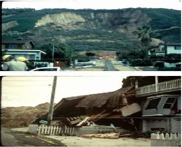
ABSTRACT: At any time, any place the planet earth may get hit by any natural hazards, where huge losses occur including human as well as economic. These events cannot be stopped, but using some innovative techniques these losses may be avoided. Among these one of major natural hazard is landslide, which was recently occur in Pune (Malingaon (MH)).Taking these approach into consideration the design and improvement in the techniques must be developed for prevention of landslide hazard. There have been several techniques to determine the landslides risk and land movement. As it is quick and sudden movement, it is necessary to keep continuous eye on environment changes i.e. real time. To make it real time monitoring system for earth environment Wireless Sensor Network (WSN) use is best suited. These paper presents the pre-landslide alert system using WSN’s, where data transmission is done by GSM module and zigbee module. In the circuitry, microcontroller is used to read the measurement done by the Wireless sensors. If their occur any changes in set threshold values, then the alerts are made from GSM modem to transmit message wirelessly to server system, also voice output is transmitted from memory module used. Finally the security alarm is also generated using Zigbee.
KEYWORDS:GSM, Landslide, Wireless Sensors, Zigbee.
I. INTRODUCTION
Due to progressive development of urban areas and infrastructure, more and more people settle in the environments such as hilly sides that have become dangerous due to different types of natural hazards. In order to this, there is need to improve basic understanding of landslides, hilly area regions where financial and social risks are more. The occurrence of landslides is a huge loss for human life and economic property and such events are fast. For such rapid events the wireless sensor techniques are best suitable as it can respond quickly to rapid changes of data and send the sensed data wirelessly to the receiver station in areas where cabling is not possible.
ISSN(Online): 2320-9801
ISSN (Print): 2320-9798
I
nternational
J
ournal of
I
nnovative
R
esearch in
C
omputer
and
C
ommunication
E
ngineering
(An ISO 3297: 2007 Certified Organization)
Vol. 4, Issue 10, October 2016
Several measurement techniques have been proposed to identify slope instability and to estimate the risk of landslide [2], [3]. Deep inclinometer displacement monitoring based on borehole tilt meter are adopted popularly on current Real-time landslide monitoring system .Signal from sensors and detection equipment’s are translated into central server by using cable or GPRS communication. Cable has obvious drawbacks such as difficulties on wiring and construction at the danger zone, man-made destroying and devastation from natural disasters. In addition, GPRS communication also has technical limitations. It cannot be used in remote mountainous areas where signal is weak even hard to be received so that qualified GPRS network is hard to be established. There are projects developed which uses satellite images it consist of combination of digital classification and textual analysis to identify landslide features [2]. Thus using satellite image includes huge processing which will conclude large calculation and complexity of the system which will make the project harder to analyze. These methods, however are known to be labor-intensive as well as costly. Wireless sensor network (WSN) technology which is utilized in reservoir area where geological hazards occurred easily is effective attempt. Because WSN itself has some better characteristics such as redundancy, wireless, the self-adaptive network and strong anti-destruction capability [1]. WSN can still complete the limited communication even though all communications facilities are damaged totally.
II. RELATED WORK
Landslides Hazards:
ISSN(Online): 2320-9801
ISSN (Print): 2320-9798
I
nternational
J
ournal of
I
nnovative
R
esearch in
C
omputer
and
C
ommunication
E
ngineering
(An ISO 3297: 2007 Certified Organization)
Vol. 4, Issue 10, October 2016
The main objectives disasters are largely unpredictable and occur within very short spans are as below
Capture relevant signals with minimum monitoring delay.
Collect, aggregate, and analyze perspective diverse and distributed data and can enable the detection of patterns that would be otherwise very hard to identify.
Wireless sensor overcome over cable structure which reduces complexity.
Wireless modules give us access to form control gateway which can be kept far from sensor deployed region.
Communication through call, SMS makes system faster.
III. SYSTEM MODEL
Proposed System:
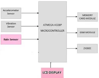
In this we have the mainly Sensor network, Microcontroller, GSM, and Zigbee. .These paper presents the pre-landslide alert system using WSN’s, where data transmission is done by GSM module and zigbee module. . If the landslides along the direction of arrow on the chips have acceleration, the output value increases. In the circuitry, microcontroller is used to read the measurement done by the Wireless sensors. If their occur any changes in set threshold values, then the alerts are made from GSM modem to transmit message wirelessly to server system, also voice output is transmitted from memory module used. Finally the security alarm is also generated using Zigbee. Hence one transmitter and two receiver section is used to cover wide area for transmission of information ass shown in fig.3.1 and fig.3.2.
Block Diagram of Transmitter and Receiver Section:
ISSN(Online): 2320-9801
ISSN (Print): 2320-9798
I
nternational
J
ournal of
I
nnovative
R
esearch in
C
omputer
and
C
ommunication
E
ngineering
(An ISO 3297: 2007 Certified Organization)
Vol. 4, Issue 10, October 2016
Figure 3.2. Block Diagram of Receiver Section
Sensors Used For Measurements:
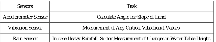
Different types of sensors are used for measuring the parameter related to land. As shown in table 1 as below there are three types of sensor mentioned, which measures the parameter of Land such as soil moisture, angle change of any slope, vibration detection. One of the most common inertial sensors is the accelerometer, a dynamic sensor capable of a vast range of sensing. Accelerometers are available that can measure acceleration in one, two, or three orthogonal axes. There are considerable advantages to using an analog accelerometer as opposed to an inclinometer such as a liquid tilt sensor – inclinometers tend to output binary information (indicating a state of on or off), thus it is only possible to detect when the tilt has exceeded some thresholding angle. The below table 1 shows the sensor used and their tasks.
Table 1. Sensors Used and Their Task
IV. RESULT AND DISCUSSION
Here the use of software Proteus 7.6 SP0 v2.0.1 is done for simulation of project just like on real chip. The most exciting and important feature of Proteus is its ability to simulate the interaction between software running on a microcontroller and any analogue or digital electronics connected to it. It simulates the execution of your object code (machine code), just like a real chip. If the program code writes to a port, the logic levels in circuit change accordingly, and if the circuit changes the state of the processor's pins, this will be seen by your program code, just as in real life. It is anything but a simple software simulator since the interaction of all these peripherals with the external circuit is fully modelled down to waveform level and the entire system is therefore simulated.
Sensors Task
Accelerometer Sensor Calculate Angle for Slope of Land.
Vibration Sensor Measurement of Any Critical Vibrational Values.
ISSN(Online): 2320-9801
ISSN (Print): 2320-9798
I
nternational
J
ournal of
I
nnovative
R
esearch in
C
omputer
and
C
ommunication
E
ngineering
(An ISO 3297: 2007 Certified Organization)
Vol. 4, Issue 10, October 2016
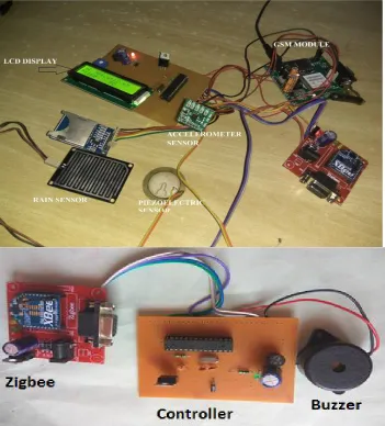
Figure 4.1 Practical model
Above figure 4.1 shows practical connection done on PCB with a well programmed ATMEGA 328P interfaced with Sensor and other modules. The Resistance of 10k is used as a fixed resistance with sensor network. LCD displays the data in digital form output obtain from microcontroller. Sensed output in voltage form is given to microcontroller. This microcontroller then convert data into digital form as ATMEGA 328P have inbuilt 10 BIT ADC.
Below are observation done while calibration of project. ADXL 335 Behaviors:
ISSN(Online): 2320-9801
ISSN (Print): 2320-9798
I
nternational
J
ournal of
I
nnovative
R
esearch in
C
omputer
and
C
ommunication
E
ngineering
(An ISO 3297: 2007 Certified Organization)
Vol. 4, Issue 10, October 2016
Figure 4.2 Axes of Acceleration Sensitivity
A well programmed microntroller have one of below condition set for detection of change in movement of Accelerometer sensor.
Below is condition set on basis of calibration done for ADXL 335.
if(x>=180 || x<=120 || y>=258 || y<=173 ) {
delay(500);
if(x>=120 || x<=180 || y>=173 || y<=258 )
As ADXL senses change in movement the voltage generated is given to microcontroller, where microcontroller converts it into digital form. After digital output obtain is then executed with the set of programmed and we get respective results . As soon as the set threshold value crossed the LCD displays as “Sending SMS for Accelerometer change” and with set time delay we receive an SMS with values of sensor and text as landslide detected. Hence ADXL sensor can give us immediate and easy idea of impact for any movement of land.
Vibration sensor behavior:
As soon as vibration is sensed by piezoelectric sensor the generated voltage is given to microcontroller for conversion into digital form.
Condition set for Peizo sensor for giving warning message is as below.
if((x>=40 || x<=330 || y>=40 || y<=330 )&&pizo>=750) {
delay(500);
if((x>=40 || x<=330 || y>=40 || y<=330 )&&pizo>=750)
This data is not separated from noise. According to area of affection it reaches its peak value. When area is less affected then it reaches at small peaks. These values are converted into digital form as having 1024 digitals levels because here we are using 10-bit ADC. And Alarm value is set as per our Requirement. When output that means Seismic signal value is greater than set value then Alarm will give Buzzer, SMS, call if not it will not provide any sound.
LCD Output:
ISSN(Online): 2320-9801
ISSN (Print): 2320-9798
I
nternational
J
ournal of
I
nnovative
R
esearch in
C
omputer
and
C
ommunication
E
ngineering
(An ISO 3297: 2007 Certified Organization)
Vol. 4, Issue 10, October 2016
Figure 4.3 LCD Display output
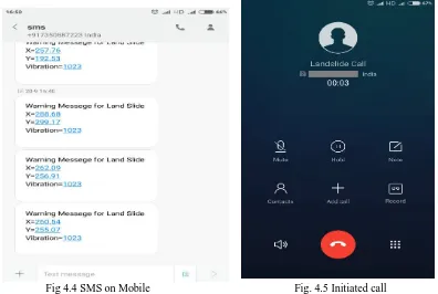
Fig 4.4 SMS on Mobile Fig. 4.5 Initiated call
ISSN(Online): 2320-9801
ISSN (Print): 2320-9798
I
nternational
J
ournal of
I
nnovative
R
esearch in
C
omputer
and
C
ommunication
E
ngineering
(An ISO 3297: 2007 Certified Organization)
Vol. 4, Issue 10, October 2016
V. CONCLUSION AND FUTURE WORK
Conclusion and Future Work
The proposed work is for monitoring the hazard of landslides and by measuring the parameters related to landslides the hazard is pre-warned before it occur. The results shows that we can obtain clear indication for landslide hazards by means of message or alarm or recorded voice call. The measurement taken by sensor are quick and efficient and displayed digitally which makes system more reliable and easy to face. Hence Landslide hazards are predicted by measuring sensed values by sensors. Study concludes about early warning of landmass likely to fail in due course of time. In future we can use optical sensor instead of electrical sensor.
Application
Can be used for Earthquake detection.
Where mountains with low vegetation, so that if landslide will be prewarned to avoid many losses.
Using WSN’s Prediction of natural hazardous becomes easy.
Mobile based apps can be developed to monitor weather condition easily.
WSN also have Several applications they include Agriculture, Health Care, Defense, Wild Life Habitat Monitoring, Under Water monitoring, Disaster Management (Safety) and Industrial (monitoring, control, factory automation) applications.
REFERENCES
1. Pengfei Zhang, IdoNevat, Gareth Peters, Gaoxi Xiao and Hwee-Pink Tan, Event Detection in Wireless Sensor Networks in Random Spatial Sensors Deployments , IEEE Transactions on Signal Processing (DOI 10.1109/TSP.2015.2452218).
2. Thomas Blaschke, BakhtiarFeizizadeh, and Daniel H¨olbling, Object-Based Image Analysis and Digital Terrain Analysis for Locating Landslides in the Urmia Lake Basin, Iran, IEEE Journal Of Selected Topics In Applied Earth Observations And Remote Sensing, Vol. 7, No. 12, December 2014.
3. Sijing Ye, Dehai Zhu, Xiaochuang Yao, Nan Zhang, Shuai Fang, and Lin Li, Development of a Highly Flexible Mobile GIS-Based System for Collecting Arable Land Quality Data, IEEE Journal Of Selected Topics In Applied Earth Observations And Remote Sensing, Vol. 7, No. 11, November 2014.
4. Linda Moser, Stefan Voigt, Elisabeth Schoepfer, and Stephanie Palmer, Multitemporal Wetland Monitoring in Sub-Saharan West-Africa Using Medium Resolution Optical Satellite Data, IEEE Journal Of Selected Topics In Applied Earth Observations And Remote Sensing, Vol. 7, No. 8, August 2014.
5. Ping Lu, André Stumpf, Norman Kerle, and Nicola Casagli, Object-Oriented Change Detection for Landslide Rapid Mapping, IEEE geoscience and remote sensing letters, vol. 8, no. 4, July 2011.
6. Maneesha V. Ramesh, Real-time Wireless Sensor Network for Landslide Detection, Third International Conference on Sensor Technologies and Applications 2009.
7. He Yueshun and Zhang Wei, The Research on wireless sensor network for landslide monitoring, International journal on smart sensing and intelligent systems vol. 6, no. 3, June 2013.
8. AkshayKanwar and AditiKhazanchi” ZIGBEE: The New Bluetooth Technology” International Journal of Engineering and Computer Science ISSN: 2319-7242 Volume1 Issue 2 Nov 2012 Page No. 67-74.
9. Mr. Chetan C. Dakave1, Dr. M. S. Gaikwad2 Angular Variation Methodology For Landslide Measurement Using Programmable System on Chip. IRJET -Volume: 02 Issue: 04 | July-2015
10. Govind Singh Bhardwaj1, Mayank Metha2, Landslide monitoring by using sensor and wireless technique,INTERNATIONAL JOURNAL OF GEOMATICS AND GEOSCIENCES, Volume 5, No 1, 2014
11. Markku Hautamäki Vaasa (2003) Using GPRS as a wireless core network for wireless local areanetworkstechnologyand communication, available at http://www.wirlab.net/pdf/ThesisGPRSwlan.pdf, accessed on 22th June, 2013.