ABSTRACT
MATNEY, JASON ANDREW. Emerging Computing Trends, Web GIS Tools, and Forecasting Methods for Geospatial Environmental Decision Support in Service of Complex Land
Management Challenges. (Under the direction of Dr. Stacy A. C. Nelson and Dr. Stacy K. Supak).
As global ecological concerns associated with climate change grow increasingly salient, professional conservationists, land managers, and public and private decision makers face increasingly complex responsibilities related to these changes. Tasks such as monitoring large-scale environmental change, responding to more frequent natural disasters, and leveraging decision support tools for managing geospatial information are becoming more important in the careers of land managers. This dissertation is comprised of three manuscripts which explore the present and future of web mapping, the application of a web-based geospatial management solution, and a comparison of time series forecasting methods. The overarching rationale is to provide decision support to land managers to assist them in addressing these grand challenges. The dissertation therefore seeks to contribute to the applied GIScience literature from a land management perspective.
The second manuscript uses the case study of the US National Park Service’s Rivers, Trails, and Conservation Assistance program as an example of how a standardized geospatial tool can be deployed within a land management decision support context. This manuscript was published in the Journal of Park and Recreation Administration in 2019. The text elucidates the background, implementation, and evaluation of a web mapping tool as developed and deployed for use by staff based in disparate US National Park Service offices. Results show that while many users found that the online tool helped to improve their access to and management of project data, the tool on the whole required migration to a cloud-based platform (e.g., ArcGIS Online) to resolve serious technical errors.
Emerging Computing Trends, Web GIS Tools, and Forecasting Methods for Geospatial Environmental Decision Support in Service of
Complex Land Management Challenges
by
Jason Andrew Matney
A dissertation submitted to the Graduate Faculty of North Carolina State University
in partial fulfillment of the requirements for the degree of
Doctor of Philosophy
Geospatial Analytics
Raleigh, North Carolina 2019
APPROVED BY:
_______________________________ _______________________________ Stacy K. Supak Stacy A. C. Nelson
Committee Co-Chair Committee Co-Chair
ii
DEDICATION
BIOGRAPHY
iv
ACKNOWLEDGMENTS
TABLE OF CONTENTS
LIST OF TABLES ... viii
LIST OF FIGURES ... ix
CHAPTER 1: INTRODUCTION ... 1
REFERENCES ... 10
CHAPTER 2: FROM GIS AS A SERVICE TO THE GEOSPATIAL BLOCKCHAIN: THE FUTURE OF THE INTELLIGENT WEB MAPPING ERA ACROSS SIX COMPUTING TRENDS ... 12
Title Page and Abstract ... 12
1. Introduction ... 14
2. Web Mapping Eras and Configurations ... 17
2.1 Eras and technologies of web mapping (early 1990s – late 2010s) ... 17
2.2 Real and theoretical applications involving Geospatial Interoperability, across Natural Resource Management and Emergency Management use cases (mid 2010s-late 2010s) ... 20
2.3 Links between Intelligent Web Mapping Era hardware and software, from the present into the future (late 2010s – early 2020s) ... 22
3. Contemporary Application Trajectories (mid 2010s – early 2020s) ... 25
3.1 Overview of Six Emerging Computing Trends within the Intelligent Web Mapping era ... 25
3.2 Trend 1: GIS as a Service – Technology + Configuration... 26
3.2.1 Cloud Infrastructure Supporting Web Services ... 26
3.2.2 What is GIS as a Service? ... 27
3.3 Trend 2: Geospatial Artificial Intelligence – Technology + Configuration ... 29
3.3.1 Classifications of Artificial Intelligence ... 29
3.3.2 GeoAI and Web Mapping ... 30
3.3.1 What is the Influence of GeoAI on the Intelligent Web Mapping Era? .... 31
3.4 Trend 3: CyberGIS – Technology + Configuration + Implementation ... 32
3.4.1 What is CyberGIS? ... 32
3.4.2 Why do we need CyberGIS? ... 32
3.4.3 How is CyberGIS being implemented? ... 33
3.4.4 CyberGIS and the Intelligent Web Mapping Era ... 34
3.5 Trend 4: Geospatial Internet of Things – Technology + Configuration ... 35
3.5.1 What is the Internet of Things? ... 35
3.5.2 Geospatial IoT and the Intelligent Web Mapping Era ... 36
3.6 Trend 5: Geospatial Blockchain – Technology + Implementation ... 37
3.6.1 What is Blockchain Technology? ... 37
3.6.2 How is Geospatial Blockchain being implemented? ... 38
3.6.3 Geospatial Blockchain and the Intelligent Web Mapping Era... 39
3.7 Trend 6: Virtual and Augmented Reality: Technology + Implementation ... 40
3.7.1 What is Virtual Reality and Augmented Reality? ... 40
3.7.2 VR & AR in the Intelligent Web Mapping Era ... 41
4. Discussion ... 43
vi
4.2 Speculation on Future Directions... 44
5. Conclusions ... 46
REFERENCES ... 51
WRAPPER 1 ... 58
REFERENCES ... 59
CHAPTER 3: IMPLEMENTATION AND EVALUATION OF A GEOSPATIAL MANAGEMENT SOLUTION FOR THE U.S. NATIONAL PARK SERVICE’S RIVERS, TRAILS, AND CONSERVATION ASSISTANCE PROGRAM ... 60
Abstract ... 61
Introduction ... 62
Literature Review... 63
The Rivers, Trails, and Conservation Assistance Program (RTCA) ... 63
Methods... 64
Needs Assessment ... 64
Implementation ... 64
Virtual Machines ... 66
Database Schema ... 67
Evaluation ... 68
Results ... 69
Discussion ... 70
Recommendations ... 70
Future Work ... 71
Conclusion ... 71
REFERENCES ... 71
WRAPPER 2 ... 73
CHAPTER 4: COMPARING THREE TIME SERIES METHODS FOR FORECASTING RECREATION VISITATION AND GEOTAGGED SOCIAL MEDIA POSTS ACROSS 12 US NATIONAL PARKS ... 74
Abstract ... 74
1. Introduction ... 76
1.1. Objectives ... 76
1.2 Background Literature ... 78
2. Methods... 79
2.1 Study Area and Data Pre-Processing ... 79
2.2 Modeling Frameworks ... 88
2.2.1 Libraries and Tools used in all Forecasting Methods ... 88
2.2.2 Auto-Regressive Moving Average (ARIMA) – Method 1 ... 88
2.2.3 Facebook Prophet – Method 2 ... 89
2.2.4 Long Short-Term Memory (LSTM) – Method 3 ... 90
3. Results ... 91
4. Discussion ... 104
6. Acknowledgements ... 106
REFERENCES ... 107
CHAPTER 5: CONCLUSION ... 110
REFERENCES ... 114
APPENDIX ... 115
viii
LIST OF TABLES
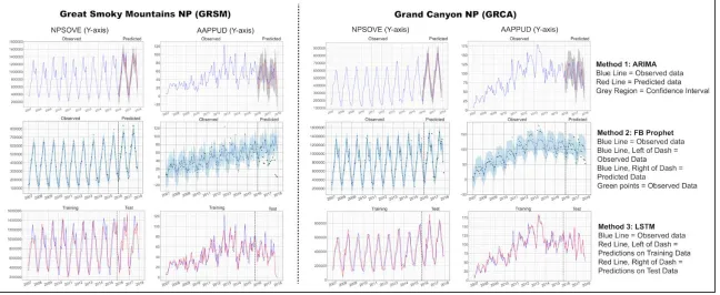
Table 1.1 RMSE and MAE results for three time series forecasting methods across recreation visitation and Flickr datasets for the 12 most-visited
LIST OF FIGURES
Figure 1.1 Original Nine Web Mapping Eras, Decadal Categorization,
and 2019 Influences ... 18 Figure 1.2 Hypothetical Emergency Management Web Mapping Application Illustrating
Emerging Computing Trends Application ... 22 Figure 1.3 Interconnecting of Hardware and Real-World Applications to Six
Technologies / Implementations / Configurations ... 24 Figure 1.4 Six Technologies / configurations / implementations Influencing
the Intelligent Web Mapping Era ... 26 Figure 2.1 Geospatial Management Solution Conceptual Diagram ... 65 Figure 2.2 Geospatial Management Solution as Envisioned from
Needs Assessment Compared to final RTCA Deployment ... 66 Figure 2.3 Enterprise Geodatabase and Virtual Machine Orientation within the
Geospatial Management Solution ... 67 Figure 2.4 Entity-Relationship Diagram ... 68 Figure 2.5 GMS RTCA User Survey Likert Scale Results ... 69 Figure 3.1 Mean Monthly Recreation Visitation for the 12 Most-Visited Contiguous
US National Parks from 2007-2017, map of Park Locations,
and park Unit Code legend ... 84 Figure 3.2 Examination of the seasonal trends for 6 US National Parks
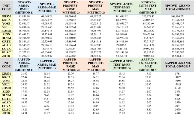
from 2007-2017 binned by month ... 87 Figure 3.3 Comparison of Yellowstone (YELL) and Grand Teton (GRTE)
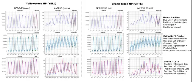
forecasting results ... 96 Figure 3.4 Comparison of Cuyahoga Valley (CUVA) and Joshua Tree (JOTR)
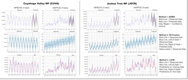
forecasting results ... 98 Figure 3.5 Comparison of Great Smokey Mountain (GRSM) and Grand Canyon (GRCA)
forecasting results ... 100 Figure 3.6 Comparisons of RMSE and MAE performance for forecasting NPSOVE
for three methods (ARIMA, Prophet, and LSTM) across Glacier,
1
CHAPTER 1: INTRODUCTION
Land managers regularly leverage sophisticated decision support tools when developing management strategies in light of the large-scale environmental challenges posed by anthropogenic climate change and natural and human imposed ecological degradation. Moreover, potential solutions to perennial concerns, such as accurately accounting for seasonal recreation visitation trends and visitor behaviors, are poised to benefit from the increasing availability scalable cloud resources and innovative machine learning methods. Emerging computing trends influencing land management include the development of sophisticated geospatial and temporal sensors and methods for data gathering, deployment of parallelized cloud-computing clusters in order to support service-based software platforms, and cultivating real-time data streams for realizing monitoring and tracking objectives. Further, interdisciplinary researchers are contributing to these trends by facilitating the use of modern geospatial data management tools for decision support. However, these developments are not necessarily universal across disciplines and research agendas, and opportunities to contribute to the growing body of knowledge related to geospatial advances of late-2010s are numerous, particularly as they relate to land management.
established web mapping application and geospatial data related computing trends, the scope and coverage of implementations that include cutting-edge cloud-based, geospatial management platforms is sporadic. Unfortunately, many land management organizations instead employ relatively inefficient geospatial data management, which hampers their ability to optimally allocate resources based on real-time geospatial developments. For example, insufficient data administration can lead to inadequate visitation monitoring strategies. Moreover, the lack of real-time geospatial data streams can limit the potential of models to estimate local flooding events (Pickering, Rossi, Hernando, & Barros, 2018).
3
• Manuscript 1 (Chapter 2) asks: What are the present and future computing trends influencing the direction of the web mapping technologies / configurations implementations in the late 2010s and early 2020s?
• Manuscript 2 (Chapter 3) asks: Can standardized needs assessment protocols paired with standardized web mapping solutions effectively support the standardization of support systems within land management agencies?
• Manuscript 3 (Chapter 4) asks: What combination of methods (modern machine learning vs. traditional statistical) and recreational visitation estimates (park service estimates vs. geotagged social media posts) leads to the best temporal forecasts for US National Park Service visitation.
These effort are well situated within the scope of that research literature, as there is a long history of land managers addressing problems utilizing web-based geospatial perspectives (Mekonnen & Gorsevski, 2015), (Tziavos et al., 2016), (Vatresia, Sadler, & Rais, 2017).
domain of Geographic Information Science (GIS) research literature and are meant to encourage the expansion of geospatial decision support opportunities for managers of park and protected areas. However, as the third manuscript aims to evaluate machine learning and statistical time series forecasting methods for recreational visitation to parks and protected areas utilizes geospatially relevant data, this work may be most pertinent within Environmental Sciences and Tourism Management domains. A brief description of each is provided below to illustrate how the three chapters address the overarching question of this dissertation.
The purpose of the 1st manuscript (Chapter 2 of this dissertation) is to lay the groundwork for
5
Chiang, 2018), (Kamel Boulos, Wilson, & Clauson, 2018), (Yan Y. Liu, Maidment, Tarboton, Zheng, & Wang, 2018), (Botta, De Donato, Persico, & Pescapé, 2016).
The findings in Manuscript 1 can be summarized by emphasizing that there are at least six emerging technologies / configurations / implementations that are independently and collectively influencing the trajectory of the current Web Mapping era. While a nine-era framework of historical web mapping developments was suitable for characterizing web mapping developments up to the late 2010s, the influence of established and emerging computing trends has rendered the future of web mapping poised for reevaluation. Web maps themselves continue to be integrated into a vast multitude of contexts, given the increasing geolocation of “smart” objects via GPS sensors, and smart environments, which leverage real-time and predictive geospatial analytics delivered via web mapping. One implication of these findings is that, moving forward, researchers should reframe their respective depictions, understanding of historical framework, and scope of any potentially trend-setting web mapping applications employed in their research. This recommendation is based on the assertion that the explanatory depth of future web mapping applications can be enriched by incorporating reflections on the technological trajectories (e.g., ubiquitous service-based platforms, IoT-enabled smart environments), defining characteristics (e.g., semantic data organization, converging mapping functionality, rapid application deployment, geospatial data interoperability), and historical antecedents (e.g., the influence of past web mapping eras) of the Intelligent Web Mapping era as outlined in Manuscript 1 (Chapter 2).
catalogs the development, deployment, implementation, and evaluation of a geospatial management solution designed for use by land managers within a nationwide community development program that is part of the US National Park Service, called the Rivers, Trails, and Conservation Assistance (RTCA) program. The geospatial management solution described in Manuscript 2 (Chapter 3) is a web mapping tool that offers decision support for land managers who desire more feature-rich geospatial management options to visualize their project management data across space. Specifically, it facilitates a central geoportal so that all staff members can access project information, regardless of location or specific agency unit, which have historically been siloing influences on communication. While no new technology was invented to support the goals of the RTCA, as the implementations are comprised of Esri (a GIS software provider) web mapping application templates, the value of Manuscript 2 (Chapter 3) lies in its novel combination of functionality to address specific needs based on a comprehensive needs assessment of geospatial capabilities and requirements (Smith, Slocumb, Smith, & Matney, 2015). This bundled set of web mapping application templates developed for one specific organization can be standardized and utilized as a framework to support decision makers within the natural resource management field.
7
system (including the geodatabase) to the cloud resolved most of these technical issues. Therefore, Manuscript 2 recommends that a standardized geospatial management solution can be paired with a standardized geospatial needs assessment when land management agencies are seeking to standardize their decision support systems. One option for developing and deploying a geospatial management solution that leverages Esri web mapping application templates is outlined in Manuscript 1 (Chapter 2), including an evaluation of the usefulness of this tool as determined by staff within a National Park Service agency that leveraged the web mapping tool to organize their geospatial data.
The 3rd manuscript (Chapter 4 of this dissertation) details a comparison of time-series forecasting
Machine Learning approach that builds on the type of Artificial Neural Network called a Recurrent Neural Network (RNN).
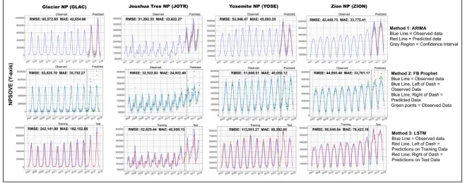
While prediction of recreation visitation has been previously attempted in the tourism literature using LSTM methods in the context of Japanese demand for travel to Hong Kong (Y. Li & Cao, 2018), Manuscript 3 (Chapter 4) strictly compares LSTM methods with more traditional statistical time series methods, and makes recommendations for land managers considering leveraging different methods to perform visitation prediction. LSTM models are distinguished from RNNs by their ability to circumvent the vanishing gradient problem, thereby being able to continue to learn without falling into a vanishing gradient of zero (Karim, Majumdar, Darabi, & Chen, 2017). While LSTM models have been analyzed in the past to assess and predict outcomes for temporal and spatially-influenced events such as sewage overflow, LSTMs have been shown to be beneficial for use with time series forecasting problems (Zhang, Lindholm, & Ratnaweera, 2018). All three time-Series forecasting methods are evaluated and compared based on the model fit, as described by the Root mean squared error, and Mean absolute error statistics, as well as their ability to predict known future values.
9
to a platform like Prophet. Importantly, Prophet was specifically designed for use by business analysts, so as to be quickly applied to all manner of univariate forecasting problems. Thus, we recommend land managers charged with balancing protected area visitor experiences and ecological conservation goals utilize Facebook Prophet to plan for future visitation.
REFERENCES
Botta, A., De Donato, W., Persico, V., & Pescapé, A. (2016). Integration of Cloud computing and Internet of Things: A survey. Future Generation Computer Systems, 56, 684–700. https://doi.org/10.1016/j.future.2015.09.021
Kamel Boulos, M. N., Wilson, J. T., & Clauson, K. A. (2018). Geospatial blockchain: promises, challenges, and scenarios in health and healthcare. International Journal of Health
Geographics, 17(1), 25. https://doi.org/10.1186/s12942-018-0144-x
Karim, F., Majumdar, S., Darabi, H., & Chen, S. (2017). LSTM Fully Convolutional Networks for Time Series Classification. IEEE Access, 6, 1662–1669.
https://doi.org/10.1109/ACCESS.2017.2779939
Li, Y., & Cao, H. (2018). Prediction for Tourism Flow based on LSTM Neural Network.
Procedia Computer Science, 129, 277–283. https://doi.org/10.1016/j.procs.2018.03.076 Liu, Y. Y., Maidment, D. R., Tarboton, D. G., Zheng, X., & Wang, S. (2018). A CyberGIS
Integration and Computation Framework for High-Resolution Continental-Scale Flood Inundation Mapping. Journal of the American Water Resources Association, 54(4), 770– 784. https://doi.org/10.1111/1752-1688.12660
Matney, J. A., Slocumb, W. S., Smith, J. W., Bonsall, P., & Supak, S. K. (2019). Implementation and Evaluation of a Geospatial Management Solution for the US National Park Service’s Rivers, Trails, and Conservation Assistance Program. Journal of Park and Recreation Administration.
Mekonnen, A. D., & Gorsevski, P. V. (2015). A web-based participatory GIS (PGIS) for offshore wind farm suitability within Lake Erie, Ohio. Renewable and Sustainable Energy Reviews, 41, 162–177. https://doi.org/10.1016/j.rser.2014.08.030
National Park Service visitation tops 318 million in 2018. (2019). Retrieved June 7, 2019, from https://www.nps.gov/orgs/1207/03-05-2019-visitation-numbers.htm
National Park Service Visitor Use Statistics. (2019). Retrieved June 7, 2019, from irma.nps.gov/Stats/
Pickering, C., Rossi, S. D., Hernando, A., & Barros, A. (2018). Current knowledge and future research directions for the monitoring and management of visitors in recreational and protected areas. Journal of Outdoor Recreation and Tourism, 21(November 2017), 10–18. https://doi.org/10.1016/j.jort.2017.11.002
11
Designing Geospatial Data Management Systems within Federal Agencies. Journal of Map & Geography Libraries, 11(2), 226–244. https://doi.org/10.1080/15420353.2015.1048035 Tziavos, I. N., Alexandridis, T. K., Aleksandrov, B., Andrianopoulos, A., Doukas, I. D.,
Grigoras, I., Grigoriadis, V. N., Papadopoulou, I. D., Savvaidis, P., Stergioudis, A., Teodorof, L., Vergos, G. S., Vorobyova, L., & Zalidis, G. C. (2016). Development of a Web-based GIS monitoring and environmental assessment system for the Black Sea: application in the Danube Delta area. Environmental Monitoring and Assessment, 188(8). https://doi.org/10.1007/s10661-016-5492-z
Vatresia, A., Sadler, J. P., & Rais, R. R. (2017). Resort Based Management Web GIS Towards Cyber Conservation in Indonesia. Sustinere: Journal of Environment and Sustainability,
1(1), 10–20. https://doi.org/10.22515/sustinere.jes.v1i1.3
Veenendaal, B., Brovelli, M. A., & Li, S. (2017). Review of Web Mapping: Eras, Trends and Directions. ISPRS International Journal of Geo-Information (Vol. 6).
https://doi.org/10.3390/ijgi6100317
Vopham, T., Hart, J. E., Laden, F., & Chiang, Y. Y. (2018). Emerging trends in geospatial artificial intelligence (geoAI): Potential applications for environmental epidemiology.
Environmental Health: A Global Access Science Source, 17(1), 1–6. https://doi.org/10.1186/s12940-018-0386-x
CHAPTER 2: FROM GIS AS A SERVICE TO THE GEOSPATIAL BLOCKCHAIN: THE FUTURE OF THE INTELLIGENT WEB MAPPING ERA ACROSS SIX
EMERGING COMPUTING TRENDS
In preparation for the Transactions of the Institute of British Geographers
Title
From GIS as a Service to the Geospatial Blockchain: The Future of the Intelligent Web Mapping Era Across Six Emerging Computing Trends
Running Title
Updating the Intelligent Web Mapping Era
Authors
Jason A. Matney1, Stacy K. Supak1, William S. Slocumb1
Affiliation
1North Carolina State University, Center for Geospatial Analytics, 2800 Faucette Dr., Campus Box
7106, Raleigh, NC 27695
Conflict of Interest Statement
13 Acknowledgements
This research was completed with the financial support of the North Carolina State University Department of Forestry and Environmental Resources under the direction of Department Head Stith T. Gower and Professor George R. Hess. This research was also supported by the US National Park Service Northeast Regional Office and the Piedmont South Atlantic Cooperative Ecosystem Studies Unit.
Abstract
Between 2017 and 2019, the practice of web mapping has evolved significantly. According to past research, this evolution has occurred within a historical framework called the Intelligent Web Mapping era. The Intelligent Web Mapping Era refers to a distinct era of web mapping evolution as defined by Veenendaal (2017), and proceeding from 2016-2019. This manuscript identifies six emerging and established computing trends which are currently influencing the present and future of web mapping. Specifically, these trends are GIS as a Service, geospatial Artificial Intelligence, CyberGIS, the Internet of Things, the geospatial blockchain, and both Augmented and Virtual reality. Literature documenting cases of web mapping applications leveraging and being influenced by these technologies / configurations / implementations in order to improve understanding of the Intelligent Web Mapping Era are discussed. The manuscript concludes with speculation regarding future web mapping research directions, and how the influences outlined in the manuscript affect the trajectory of web mapping through the early 2020s.
1. Introduction
Researchers regularly leverage the framework of historical eras when classifying technological progression. According to Veenendaal and colleagues, the Intelligent Web Mapping Era (2016-2019), “embraces semantic technologies and smart environments that provide knowledge, context and customization to the information delivered to users and applications” (Veenendaal et al., 2017). These smart environments are typified by real-time and predictive geospatial analytics (e.g., emergency management platforms) delivered via web mapping tools that offer decision support information through user interaction. Knowledge, context, and customization within these smart environments are made possible by ubiquitous late 2010s computing trends, such as widespread adoption of low-cost cloud computing, parallelized processing, and distributed server infrastructure. Specific to geospatial infrastructure, cyberinfrastructure frameworks, built to utilize high-performance, distributed, cloud-based computing clusters are critical to the Intelligent Web Mapping Era (Shaowen Wang, 2016). Further, these frameworks support emerging computing technologies (e.g. machine learning methods) that are transforming geospatial intelligence by providing automated insight generation (Dold & Groopman, 2017). This ongoing convergence of computing advancements, enabled by scalable resources, underpins the emergence of the late 2010s geovisualization paradigm for which web mapping is the key method of dissemination (Zbakh, Bakhouya, Essaaidi, & Manneback, 2018).
15
interactive interfaces to provide users with the ability to store, process, and visualize geospatial data using web protocols (Nakayama, Nakamura, Saito, & Fukumoto, 2017). Within the Intelligent Web Mapping Era, the term web mapping carries expectations for integration of automated artificial intelligence, utilization of cloud computing, as well as in-application analysis and dynamic geovisualization. These expectations are all parts of a broader shift toward web mapping encompassing more dynamic, immersive environments augmented by intuitive user interfaces and real-time data streams (Sack, 2018). Thus, the term web mapping has evolved from describing static web maps that simply display previously collected data to complex enterprise-level cloud-based web GIS platforms that provide a variety of customized geospatial analysis tools necessary for real-time and predictive decision support.
intelligently contextualize and deliver knowledge in many domains, researchers are rapidly adopting new technologies / configurations / implementations for transforming heterogeneous geographic data into discrete information that can be delivered via web mapping technologies.
17 2. Web Mapping Eras & Configurations
2.1. Eras and technologies of web mapping (early 1990s – late 2010s)
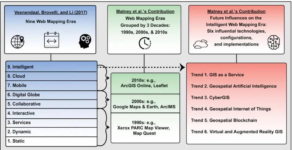
Figure 1 – Original Nine Web Mapping Eras, Decadal Categorization, and Future Influences This figure emphasizes the placement and unique nature of the Intelligent Web Mapping Era as compared to Veenendaal’s nine-era framework, as seen in the blue (left) panel. Web mapping eras can be condensed across decades to observe groups of defining trends, as seen in the green (middle) panel. The Intelligent Web Mapping Era is being influenced by six technologies / configurations / implementations as seen in the red (right) panel.
19
ArcGIS Online web maps can be consumed on a smartphone mobile device for cloud-stored data collection in the field). In the late 2010s, web mapping applications began incorporating aspects of emerging algorithmic and semantic intelligence to efficiently organize information and autonomously generate new knowledge; hence, the naming of Intelligent Web Mapping Era.
2.2. Real and theoretical applications involving Geospatial Interoperability across Natural Resource Management and Emergency Management use cases (mid 2010s-late 2010s) The demand for cloud-based geospatial analysis has historically been particularly acute for working to protect natural resources against a variety of threats, including drought, wildfire, and flooding. Web mapping applications are uniquely tailored to natural resource management because of the complex nature of geospatially and temporally intersecting threats managed under the umbrella of decision support for natural resource administration, necessitating interactive geovisualization (Navarro, Ingram, Kerry, Ortiz, & Scully, 2017). Applications that leverage web mapping and pertain to topics such as infrastructure assessment for wind exposure, costal flood inundation simulation, and water quality monitoring, have been detailed among various publications (Kovanen, Oksanen, & Sarjakoski, 2018), (Repetto et al., 2018), (Muchini, Gumindoga, Togarepi, & Masarira, 2018).
21
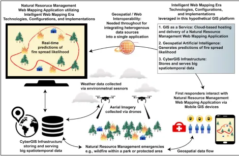
Figure 2 – Hypothetical Emergency Management Web Mapping Application Illustrating Emerging Computing Trends Application
This figure presents a speculative diagram of a potential emergency management web mapping use case wherein emerging technologies are employed. Additionally, the role of Geospatial Interoperability is relevant to this scenario, as heterogeneous data sources are to be incorporated into a single application. The hypothetical use case focuses on a real-time web mapping system which is deployed before, during, and after emergency wildfire scenarios.
2.3. Links between Intelligent Web Mapping Era hardware and software, from the present into the future (late 2010s – early 2020s)
23
means of marking this shift in the value, application potential, reach, and scope of web mapping into the early 2020s.
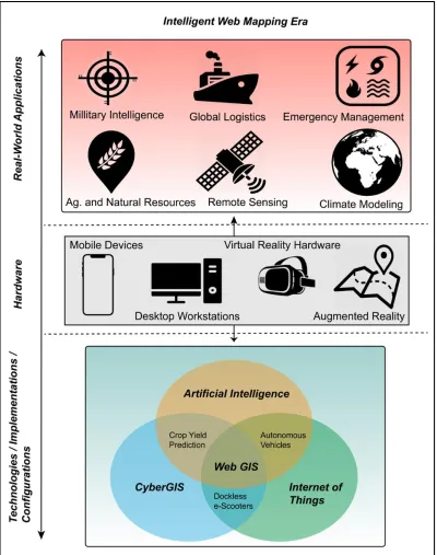
Figure 3 – Interconnecting of Hardware and Real-World Applications to Six Technologies / configurations / implementations
25
3. Contemporary Application Trajectories (mid 2010s – early 2020s)
3.1. Overview of Six Emerging Computing Trends within the Intelligent Web Mapping era
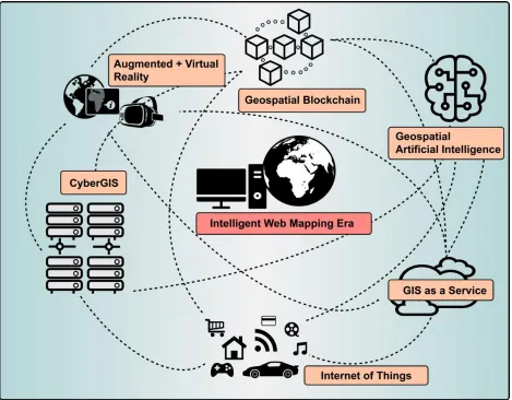
Figure 4 – Six technologies / configurations / implementations influencing the Intelligent Web Mapping Era
This figure highlights the six computing trends which are increasingly incorporated into web mapping applications, as cataloged in the academic literature from 2017-2019. As these technologies are becoming more established, they are also becoming further incorporated into the broader conception of GIS Technology.
3.2. Trend 1: GIS as a Service – Technology + Configuration 3.2.1. Cloud Infrastructure Supporting Web Services
27
2018). According to Liu and Song in 2018, cloud infrastructure is actively being leveraged to provide virtual resources for geospatial applications (Y. Liu & Song, 2018). Specifically, as of 2019, there are three primary methods of distributing “pre-packaged” computing resources as services over the internet and through the web by leveraging cloud infrastructure (Y. Liu & Song, 2018):
• Software as a Service (SaaS), where software operating on distributed resources is
accessed through the web, e.g., Microsoft Office 365 and Salesforce.
• Platform as a Service (PaaS) where applications are managed, but not maintained by
users, e.g., Windows Azure, & Heroku.
• Infrastructure as a Service (IaaS), which encompasses the use of virtual machines that
support the management of applications within the virtualized operating system, e.g., Amazon Web Services.
3.2.2. What is GIS as a Service?
storage and processing capabilities paired with real-time location tracking, GaaS is situated to become an important contributor to the future of the Intelligent Web Mapping Era (Garg et al., 2017).
While GaaS is cost-effectiveness and provide the ability to manage big data by leveraging large amounts of computing resources (Garg et al., 2017), there are notable weaknesses. One significant disadvantage is the lack of user control, which would apply to any SaaS as compared to a program that is installed on the user’s local machine. Another drawback to future adoption of GaaS across many domains is that these types of services may have intermittent delays, bandwidth limitation, and other performance issues inherent to web-based applications (Chelliah & Kumar, 2017). Further, service outages may require more complex troubleshooting of remote resources, which cannot be resolved by the user, as opposed to troubleshooting localized infrastructure which has the potential to be corrected. Despite these weaknesses, recent research into distributed high-speed caching services can help mitigate problems associated with web mapping applications that leverage cloud computing resources, including network congestion and server overload (R. Li, Feng, Wu, & Huang, 2017).
29
leading to optimal allocation of police officers based on real-time data. As utilization of rapid deployment solutions becomes more ubiquitous, thanks in part due to the widespread utilization of parallelized, distributed, cloud computing environments, GaaS will become more of an organizing principle for web mapping applications in the Intelligent Web Mapping era.
3.3. Trend 2: Geospatial Artificial Intelligence – Technology + Implementation 3.3.1. Classifications of Artificial Intelligence
One defining characteristic of the Intelligent Web Mapping Era is the influence of “…automated and semi-automated decision-making” (Veenendaal et al., 2017). Researchers and developers automate decision making by leveraging iterative algorithms. Artificial Intelligence (AI) refers to the scientific study, development, and implementation of sophisticated algorithms with the goal of organizing computers to replicate functions of human intelligence, and behave as if they were human beings (Ertel, 2018). AI is widely used as a broad term that covers different implementations. As of 2019, AI implementations can be identified in diverse fields such as biostatistics, econometrics, and weather forecasting. Below are descriptions of and distinctions between two important AI implementations:
• Machine Learning (ML) is a branch of AI that refers to methods of automating the
Forests ML algorithms and a Gradient Boosting ML algorithm (Ahabchane, Trépanier, & Langevin, 2019).
• Deep Learning (DL) is a branch of AI that focuses on studying the ability of computers
to hierarchically organize concepts in order to learn concepts without human intervention (Goodfellow, Bengio, & Courville, 2016). An example of research that pairs DL and geospatial data is a 2019 publication by Mubin et al., wherein the authors predict both young and mature oil palm for plantation management using two different Convolutional Neural Networks (CNN), which represent a type of DL algorithm (Mubin, Nadarajoo, Shafri, & Hamedianfar, 2019).
3.3.2 GeoAI and Web Mapping
31
analysis within AI implementations, the specific terminology ‘GeoAI’ is just beginning to gain traction.
Geospatial data is important to some AI implementations; however, utilizing geospatial data is not the same as incorporating AI into geospatial tools to support geospatial analytics. Geospatial tools are those that support the manipulation of geospatial data, such that new information can be derived. While there is a rich history of AI and geospatial tools being utilized in various desktop GIS applications, such as automating geospatial prediction of wildlife presence, as of 2019, the majority of research publications describing the use GeoAI, ML, and DL within geospatial analytics do not mention web mapping applications or GaaS (Jaafari, Zenner, Panahi, & Shahabi, 2019). This is likely because leveraging GeoAI can be computationally demanding (e.g. predicting surface water quality measurements from remotely sensed images), especially so when integrated with web mapping applications (Sharaf El Din, Zhang, & Suliman, 2017), (Tien Bui et al., 2017). However, as GaaS becomes more widely adopted, GeoAI should become more readily integrated in to web mapping applications.
3.3.3. What is the Influence of GeoAI on the Intelligent Web Mapping Era?
classification through the application of decision trees, could be utilized to automatically categorize pixels in a landscape based on their likelihood to be burned by active wildfires, in order to efficiently index them for search by emergency responders via a web mapping interface. This would aid emergency responders in prioritizing certain, high-likelihood locations in their response strategies.
3.4 Trend 3: CyberGIS – Technology + Configuration + Implementation 3.4.1 What is CyberGIS?
As of 2019, CyberGIS is a widely utilized platform within GIScience. Wang in 2016 defined CyberGIS technology as “geographical information science and systems based on advanced cyberinfrastructure and e-science” (Shaowen Wang, 2016). E-science is a term that was used by researchers during the 2000s to describe early efforts to conceptualize newfound collaborations between traditional physical scientists and computer scientists (Deelman, Gannon, Shields, & Taylor, 2009). As of the late 2010s, the term E-science is not widely used, as collaborations between computer scientists and physical scientists are widely encouraged across university campuses. However, the term was useful in the late 2000s and early 2010s to help outline Wang’s vision of CyberGIS and specifically its ability to support efforts surrounding longstanding geospatial problem solving in diverse fields and across multiple geographic locations (Shaowen Wang, 2016).
3.4.2 Why do we need CyberGIS?
33
data continue to increase (Yang, Yu, Hu, Jiang, & Li, 2017). Performing parallelized geoprocessing operations in a cloud environment can provide the possibility to generate answers to climate-scale complex questions, where before the use of CyberGIS, those questions could not be adequately answered in a standard desktop environment. As researchers often seek to answer questions that encompass broad geospatial and temporal scales specific to their field of study, domain-specific geoprocessing tools and workflows become more important. CyberGIS is one way to support researchers by providing “domain-specific tools and workflow capabilities for individual science domains. [CyberGIS] typically include[s] the most popular tools from their
scientific domain with dedicated gateway developers maintaining and adding such tools”
(Kalyanam et al., 2019).
3.4.3. How is CyberGIS being implemented?
3.4.4. CyberGIS and the Intelligent Web Mapping Era
As CyberGIS has the capacity to support resource-intensive geospatial data organization, storage, and analysis necessary for large scale GaaS, geoportals, and geovisualization, CyberGIS stands to influence web-based applications. Research further supports this notion that Cyberinfrastructure is useful for generating real-time geospatial analysis within web-based applications. For example, CyberGIS has contributed to the storage and serving of petabytes of climate related data necessary for the production of climate models, the analysis of which can be performed and made accessible via web mapping applications (Yang et al., 2017).
35
facilitate user interaction with geospatial data stored in cyberinfrastructure (Chmielewski, Samulowska, Lupa, Lee, & Zagajewski, 2018).
3.5. Trend 4: Geospatial Internet of Things – Technology + Configuration 3.5.1. What is the Internet of Things?
geospatially-indexed data streams, specifically automatic optimal bus stop identification for urban bus routes that maximize passenger carrying capacity (H. Cao & Wachowicz, 2019).
3.5.2. Geospatial IoT and the Intelligent Web Mapping Era
As geospatial IoT facilitates the widespread sensing of specific locational data (e.g., temperature, water level, speed), opportunities for analysis of this geospatial data (e.g., hotspots and trends) and the subsequent optimization of IoT-linked objects (e.g., adjusting sewer systems based on sensed water levels) become more common place. Further, complimentary characteristics shared by IoT and cloud computing, such as incorporating fluid information flows while balancing input flexibility with schematic and semantic standardization through the use of distributed parallel cloud resources, can ease the rapid visualization of IoT-sensed objects over the web (Botta et al., 2016). In 2016, Botta et al. called this extensive merging of cloud computing services with IoT sensing and analysis networks the “CloudIoT paradigm”.
37
3.6. Trend 5: Geospatial Blockchain – Technology + Implementation 3.6.1. What is Blockchain Technology?
Blockchain technology utilizes distributed ledger technology to facilitate crowdsourced, traceable, timestamped transactions by “hashing them into an ongoing chain of hash-based proof-of-work”, according to the technology’s inventor Nakamoto (Nakamoto, 2008). According to Zamani and Giaglis in 2018, “distributed ledger technology, also known as blockchain... creates online, distributed and publicly available ledgers that are updated by every node of a peer-to-peer network. This is based on the consensus of the nodes, with the use of a proof-of-work or similar consensus algorithm, and without the mediation of a trusted third party. This means that the nodes, i.e., the peers or the miners, agree which ‘block’ should be added next on the ‘chain’, forming eventually the blockchain” (Zamani & Giaglis, 2018).
3.6.2. How is Geospatial Blockchain being implemented?
39
3.6.3. Geospatial Blockchain and the Intelligent Web Mapping Era
The Geospatial Blockchain could be a technology that the holds the promise of altering fundamental security components of web mapping tool implementation (e.g. protected data entry) and opening up possibilities for novel applications, such as, according to a chief exponent of the concept, “the production and real-time updating of an augmented crisis map for navigating a disaster- stricken area” (Kamel Boulos et al., 2018). The value of trusted, peer-to-peer location authentication as a contributing feature to the Intelligent Web Mapping era is underscored when considering the potential vulnerability of IoT-based systems that are poised to be implemented on a city or nationwide scale. For example, geospatial blockchain could be leveraged for use within IoT-powered autonomous vehicle to prevent hijacking of the vehicle’s navigation system by a malicious third-party (Dasgupta, 2017).
3.7. Trend 6: Virtual and Augmented Reality GIS: Technology + Implementation 3.7.1. What is Virtual Reality and Augmented Reality?
Virtual Reality (VR) and Augmented Reality (AR) technologies and implementations offer the ability for a user to interact with computer-generated, three-dimensional (3D) environments or objects across two distinct platform frameworks:
1. According to Cipresso et al. in 2018, “The concept of Virtual Reality [can] be traced to the [mid-1960s] when Ivan Sutherland in a pivotal manuscript attempted to describe VR as a window through which a user perceives the virtual world as if [it] looked, felt, [and] sounded real and in which the user could act realistically” (Cipresso, Giglioli, Raya, & Riva, 2018). In other words, VR refers to an immersive digital experience designed to dislocate users from their physical location and transport their sense of place into an artificial environment. The most effective VR experiences trigger the senses into imbuing a sense of reality to a digital 3D environment, temporarily causing users to disregard the fact they are interacting with a digital landscape.
41 3.7.2. VR & AR in the Intelligent Web Mapping Era
GIS researchers have envisioned a series of potential applications for VR and AR paired with geospatial analytics and web mapping. The concept of Virtual Reality GIS (VRGIS) holds potential moving forward, given the ability to commercially produce a device capable of being integrated within virtual geographic environments at scale. Indeed, Wand and colleagues in 2017 cataloged a platform for performing three dimensional routing queries, navigation, and viewable area analysis within a VRGIS environment (W. Wang et al., 2018). Boulos and colleagues in 2017 claimed, “Traditional urban and environmental applications of VRGIS focus on the simulation of landscape structure; geomorphological structure; geological structure; large-scale traffic and urban engineering structure; natural movements of the Earth system” (Kamel Boulos et al., 2017).
requiring physical movement) is cited as an example of a successful health-related application of ARGIS, which identifies these creatures within a web map, accessed through a smartphone application (Kamel Boulos et al., 2017). According to Çöltekin et al. in 2019, “with continued development of the ‘Internet of Things’ (IoT), … mobile AR applications will eventually allow us to point our device to any object containing a chip and data connection to show visually enriched information” (Çöltekin, Oprean, Wallgrün, & Klippel, 2019).
43 4. Discussion
4.1. Future (early 2020s and beyond)
• GaaS – Efficiently implementing the GIS processing power necessary for conducting geospatial analysis in real-time. Cloud computing could support the semantic organization and delivery of geospatial data in real-time.
• GeoAI - Automating the generation of fire spread forecasts as new data become available. Real-time iterations of fire spread forecasted support analysts in making recommendations based on the most current information.
• CyberGIS - Building out the cyberinfrastructure likely necessary for such an ambitious emergency management system. For instance, CyberGIS could support larger geospatial extents, higher data collection rates, and more complex data structures for data layers. • IoT - Sensing environmental conditions (e.g., temperature, moisture, etc.) present in areas
which stand to be affected by fire spread, relaying this information in nearly real-time. • Geospatial Blockchain - Authenticating the GPS reported location of emergency
responders who are deployed to assist with fire containment.
• VR/ARGIS - Providing first-responders with real-time visualizations of forecasted fire spread for different potential conditions (e.g. shifts in wind direction).
4.2. Speculation on Future Directions
45
integration of web mapping into computing frameworks will likely be defined by how effectively researchers and users can adjust to shifting data-intensive and machine-intelligent paradigms. While society at large tends to be reactive rather than proactive when it comes to slow moving hazards, data-intensive and machine-intelligent paradigms offer an opportunity to be more proactive. For example, when natural resource managers are preparing for potential environmental emergencies, some authoritative geolocated information streams do exist (Mikovits et al., 2017); however, to truly shift the paradigm these information streams need to be leveraged such that managers can apply their new knowledge swiftly and with confidence. In this way, early adoption of web mapping applications can facilitate more proactive decision making, as these tools generate actionable knowledge for decision support (Mikovits et al., 2017).
may already be the case as far as concerns the companies that facilitate this spatial data collection, users of web maps (on the whole) have not yet begun to conceptualize themselves as fundamentally serving as roaming data collection vessels that support profit generation for a select few providers.
5. Conclusion
47
While the deployment of web mapping across academic domains and social interests provides many societal and personal benefits, there are also potential disadvantages. Drawbacks such as privacy concerns, geospatial systems security and fragility, and questions surrounding the legislation and fair-use of new technologies, especially when profit motives are involved, all stand to shape the future of the Intelligent Web Mapping Era in the 2020s and beyond. The scope of these benefits and weaknesses will be defined in part by legislation introduced to restrict or permit those in control of web mapping technologies to leverage sensitive, personally-identifiable information. Enforcement of restrictions on disruptive technology has historically been a necessary counterweight to the challenges sparked by innovation. For instance, geospatial applications which leverage AR to generate data-enriched user experiences also are expected to gain greater attention from federal regulators. Indeed, as web mapping applications are combined with Internet of Things-style connectivity of devices through the use of CyberGIS infrastructure, the ability to incorporate AR into smartphones will likely become more widely scrutinized.
computing resources used to support multi-user workflows (Agus, Silalahi, Armanda, & others, 2018).
The historical trajectory of web mapping, from its inception in the early 1990s up until 2017, has been extensively tracked in the GIScience literature. As of 2019 however, several technologies / configurations / implementations have emerged from 2017-2019, and either are currently influencing, or stand to potentially alter the future of the Intelligent Web Mapping era. Specifically, GaaS has allowed developers to more rapidly deploy web mapping frameworks that incorporate geospatial analysis. GeoAI has opened the possibility for web mapping developers to automate insight generation through computational learning (e.g., pattern-identification in agricultural remote imagery). CyberGIS has identified the cyberinfrastructure and software pairings (e.g., ROGER, Apache Spark, etc.) necessary to handle and consume large geospatial datasets for geovisualization. IoT has supplied the framework for generating spatially-explicit intelligence from, for instance, GPS monitoring of millions of remotely-tracked objects. Geospatial Blockchain has provided a vision of a future where peer-to-peer spatial authentication of GPS-tacked objects can be accomplished by developing distributed blockchain-enabled services for consumption by web mapping applications. Finally, GIS AR & VR have emerged as potential innovative methods for facilitating deeper user immersion within web mapping environments, opening up new web mapping application possibilities such as ARGIS-aided medical applications using augmented reality to highlight spatial patterns in the human body.
49
continue to defy exact categorization as of 2019. Indeed, an inflection point may be approaching in GIScience researchers’ understanding of the historical trajectory of web mapping. This is because the Intelligent Web Mapping era can be, in part, defined by its lack of strict representation by a singular technology. Of course, Veenendaal’s 2017 characterization of the era as revolving around semantic organization of knowledge and automated insight generation maintains its accuracy, and should be seen as complimentary to the points made in this manuscript. However, when web mapping applications are near-ubiquitously leveraged as a central point-of-access to a global dockless transpiration network (one that allows users to track electric bikes and scooters throughout urban areas in real-time), it is clear that the role of web mapping in society has fundamentally transformed from past iterations, and is only becoming a more paramount influence in shaping human navigation behavior. As such, web mapping in the early 2020s will likely profit from the trends explicated above, among unforeseen advancements in the near future. Furthermore, these web mapping tools will likely only become more foundational to users’ cognitive spatial architecture, as users become increasingly trained to interact with web maps using, among other tools, their fingers to pinch and zoom via hand gestures, their eyes to perform pattern identification and route-finding, and their minds to gather and assimilate increasingly complex, nuanced, and sizeable amounts of spatial information.
51
REFERENCES
Abadi, M. … Brain, G. (2016). TensorFlow: A System for Large-Scale Machine Learning TensorFlow: A system for large-scale machine learning. 12th USENIX Symposium on Operating Systems Design and Implementation (OSDI ’16), 265–284. Retrieved from https://www.usenix.org/conference/osdi16/technical-sessions/presentation/abadi
Abdalla, R., & Esmail, M. (2019). Cloud Computing and WebGIS for Disaster and Emergency Management. In WebGIS for Disaster Management and Emergency Response (pp. 63–71). Cham: Springer International Publishing. https://doi.org/10.1007/978-3-030-03828-1_7 Agus, F., Silalahi, W., Armanda, A., & others. (2018). Mapping urban green open space in
Bontang city using QGIS and cloud computing. In IOP Conference Series: Earth and Environmental Science (Vol. 144, p. 12032).
Ahabchane, C., Trépanier, M., & Langevin, A. (2019). Street-segment-based salt and abrasive prediction for winter maintenance using machine learning and GIS. Transactions in GIS,
23(1), 48–69.
Bhanumurthy, V., & Sharma, V. K. (2019). Integration of Multiple Technologies in Web Environment for Developing an Efficient Framework for Emergency Management. In P. J. Rao, K. N. Rao, & S. Kubo (Eds.), Proceedings of International Conference on Remote Sensing for Disaster Management (pp. 159–171). Cham: Springer International Publishing. Bibri, S. E. (2018). The IoT for smart sustainable cities of the future: An analytical framework
for sensor-based big data applications for environmental sustainability. Sustainable Cities and Society, 38(December 2017), 230–253. https://doi.org/10.1016/j.scs.2017.12.034 Bivand, R., & Krivoruchko, K. (2018). Big data sampling and spatial analysis: “which of the two
ladles, of fig-wood or gold, is appropriate to the soup and the pot?” Statistics and Probability Letters, 136, 87–91. https://doi.org/10.1016/j.spl.2018.02.012
Bogdanović, M., Stanimirović, A., & Stoimenov, L. (2015). Methodology for geospatial data source discovery in ontology-driven geo-information integration architectures. Journal of Web Semantics, 32, 1–15. https://doi.org/10.1016/j.websem.2015.01.002
Botta, A., De Donato, W., Persico, V., & Pescapé, A. (2016). Integration of Cloud computing and Internet of Things: A survey. Future Generation Computer Systems, 56, 684–700. https://doi.org/10.1016/j.future.2015.09.021
Calkin, D. E., Thompson, M. P., Finney, M. a, & Hyde, K. D. (2011). A Real-Time Risk Assessment Tool Supporting Wildland Fire Decisionmaking. Journal of Forestry,
109(August), 274–280.
https://doi.org/10.1016/j.compenvurbsys.2018.11.004
Chelliah, P. R., & Kumar, S. A. P. (2017). A Cloud-Based Service Delivery Platform for Effective Homeland Security. In 2017 IEEE 4th International Conference on Cyber Security and Cloud Computing (CSCloud) (pp. 157–162).
Chmielewski, S., Samulowska, M., Lupa, M., Lee, D., & Zagajewski, B. (2018). Citizen science and WebGIS for outdoor advertisement visual pollution assessment. Computers,
Environment and Urban Systems, 67, 97–109.
https://doi.org/10.1016/j.compenvurbsys.2017.09.001
Cipresso, P., Giglioli, I. A. C., Raya, M. A., & Riva, G. (2018). The past, present, and future of virtual and augmented reality research: A network and cluster analysis of the literature.
Frontiers in Psychology, 9(NOV), 1–20. https://doi.org/10.3389/fpsyg.2018.02086
Çöltekin, A., Oprean, D., Wallgrün, J. O., & Klippel, A. (2019). Where are we now? Re-visiting the Digital Earth through human-centered virtual and augmented reality geovisualization environments. International Journal of Digital Earth, 12(2), 119–122.
https://doi.org/10.1080/17538947.2018.1560986
Dasgupta, A. (2017). The Game Changer of Geospatial Systems — Blockchain. Retrieved May 16, 2019, from https://www.geospatialworld.net/article/blockchain-geospatial-systems/ Deelman, E., Gannon, D., Shields, M., & Taylor, I. (2009). Workflows and e-Science: An
overview of workflow system features and capabilities. Future Generation Computer Systems, 25(5), 528–540. https://doi.org/10.1016/j.future.2008.06.012
Dold, J., & Groopman, J. (2017). The future of geospatial intelligence. Geo-Spatial Information Science, 20(2), 151–162. https://doi.org/10.1080/10095020.2017.1337318
Ellehauge, J. (2016). Blockchain in Geospatial Applications. Ertel, W. (2018). Introduction to artificial intelligence. Springer.
Evans, M. R., Oliver, D., Yang, K., Zhou, X., Ali, R. Y., & Shekhar, S. (2019). Enabling spatial big data via CyberGIS: Challenges and opportunities. In CyberGIS for Geospatial
Discovery and Innovation (pp. 143–170). Springer.
Fargher, M. (2018). WebGIS for Geography Education: Towards a GeoCapabilities Approach.
ISPRS International Journal of Geo-Information, 7(111), 1–15. https://doi.org/10.3390/ijgi7030111
53
González, D. A., Gleeson, J., & McCarthy, E. (2019). Designing and developing a web tool to support Strategic Environmental Assessment. Environmental Modelling and Software,
111(October 2018), 472–482. https://doi.org/10.1016/j.envsoft.2018.10.014 Goodfellow, I., Bengio, Y., & Courville, A. (2016). Deep learning. MIT press.
He, Y., Zhang, D., & Fang, Y. (2017). Development of a mobile post-disaster management system using free and open source technologies. International Journal of Disaster Risk Reduction, 25(November 2016), 101–110. https://doi.org/10.1016/j.ijdrr.2017.08.007 Jaafari, A., Zenner, E. K., Panahi, M., & Shahabi, H. (2019). Hybrid artificial intelligence
models based on a neuro-fuzzy system and metaheuristic optimization algorithms for spatial prediction of wildfire probability. Agricultural and Forest Meteorology, 266–267(January), 198–207. https://doi.org/10.1016/j.agrformet.2018.12.015
Jo, I., Hong, J. E., & Verma, K. (2016). Facilitating spatial thinking in world geography using Web-based GIS. Journal of Geography in Higher Education, 8265(June).
https://doi.org/10.1080/03098265.2016.1150439
Kalyanam, R., Zhao, L., Song, C., Biehl, L., Kearney, D., Kim, I. L., Shin, J., Villoria, N., & Merwade, V. (2019). MyGeoHub—A sustainable and evolving geospatial science gateway.
Future Generation Computer Systems, 94, 820–832. https://doi.org/10.1016/j.future.2018.02.005
Kamel Boulos, M. N., Lu, Z., Guerrero, P., Jennett, C., & Steed, A. (2017). From urban planning and emergency training to Pokémon Go: Applications of virtual reality GIS (VRGIS) and augmented reality GIS (ARGIS) in personal, public and environmental health. International Journal of Health Geographics, 16(1), 1–12. https://doi.org/10.1186/s12942-017-0081-0 Kamel Boulos, M. N., Wilson, J. T., & Clauson, K. A. (2018). Geospatial blockchain: promises,
challenges, and scenarios in health and healthcare. International Journal of Health Geographics, 17(1), 25. https://doi.org/10.1186/s12942-018-0144-x
Khasha, R., Sepehri, M. M., Mahdaviani, S. A., & Khatibi, T. (2018). Mobile GIS-based
monitoring asthma attacks based on environmental factors. Journal of Cleaner Production,
179, 417–428. https://doi.org/10.1016/j.jclepro.2018.01.046
Kitchin, R., & McArdle, G. (2016). What makes Big Data, Big Data? Exploring the ontological characteristics of 26 datasets. Big Data & Society, 3(1), 205395171663113.
https://doi.org/10.1177/2053951716631130
Kovanen, J., Oksanen, J., & Sarjakoski, T. (2018). Near real-time coastal flood inundation simulation with uncertainty analysis and GPU acceleration in a web environment.
Kubat, M. (2017). An introduction to machine learning (Vol. 2). Springer.
Li, R., Feng, W., Wu, H., & Huang, Q. (2017). A replication strategy for a distributed high-speed caching system based on spatiotemporal access patterns of geospatial data. Computers, Environment and Urban Systems, 61, 163–171.
https://doi.org/10.1016/j.compenvurbsys.2014.02.009
Li, W., Goodchild, M. F., Anselin, L., Weber, K. T., Jiang, L., Yue, P., Kuhn, W., Zhang, C., Yu, C., & Guo, X. (2019). A Smart Service-Oriented CyberGIS Framework for Solving Data-Intensive Geospatial Problems. In Shaowen Wang & M. F. Goodchild (Eds.),
CyberGIS for Geospatial Discovery and Innovation (Vol. 117, pp. 189–211). Dordrecht: Springer Netherlands. https://doi.org/10.1007/978-94-024-1531-5_10
Liu, Y., & Song, H. (2018). Levering Mobile Cloud Computing for Mobile Big Data Analytics. In G. Skourletopoulos, G. Mastorakis, C. X. Mavromoustakis, C. Dobre, & E. Pallis (Eds.),
Mobile Big Data: A Roadmap from Models to Technologies (pp. 21–39). Cham: Springer International Publishing. https://doi.org/10.1007/978-3-319-67925-9_2
Matney, J. A., Slocumb, W. S., Smith, J. W., Bonsall, P., & Supak, S. K. (2019). Implementation and Evaluation of a Geospatial Management Solution for the US National Park Service’s Rivers, Trails, and Conservation Assistance Program. Journal of Park and Recreation Administration.
McCord, P., Tonini, F., & Liu, J. (2018). The Telecoupling GeoApp: A Web-GIS application to systematically analyze telecouplings and sustainable development. Applied Geography,
96(May), 16–28. https://doi.org/10.1016/j.apgeog.2018.05.001
Mikovits, C., Tscheikner-Gratl, F., Jasper-Tönnies, A., Einfalt, T., Huttenlau, M., Schöpf, M., Kinzel, H., Rauch, W., & Kleidorfer, M. (2017). Decision Support for Adaptation Planning of Urban Drainage Systems. Journal of Water Resources Planning and Management,
143(12), 04017069. https://doi.org/10.1061/(ASCE)WR.1943-5452.0000840
Mubin, N. A., Nadarajoo, E., Shafri, H. Z. M., & Hamedianfar, A. (2019). Young and mature oil palm tree detection and counting using convolutional neural network deep learning method.
International Journal of Remote Sensing, 0(0), 1–16. https://doi.org/10.1080/01431161.2019.1569282
Muchini, R., Gumindoga, W., Togarepi, S., & Masarira, T. P. (2018). Near real time water quality monitoring of Chivero and Manyame lakes of Zimbabwe, 85–92.
Nakamoto, S. (2008). Bitcoin: A Peer-to-Peer Electronic Cash SyNakamoto, S. (2008). Bitcoin: A Peer-to-Peer Electronic Cash System. Consulted, 1–9. doi:10.1007/s10838-008-9062-0stem. Journal for General Philosophy of Science, 39(1), 53–67.
https://doi.org/10.1007/s10838-008-9062-0
55
Participatory Sensing Service: An Open Source-Based Implementation. Geosciences, 7(2), 22. https://doi.org/10.3390/geosciences7020022
Navarro, F., Ingram, B., Kerry, R., Ortiz, B. V., & Scully, B. T. (2017). A Web-based GIS Decision Support Tool for Determining Corn Aflatoxin Risk: A Case Study Data from Southern Georgia, USA. Advances in Animal Biosciences, 8(02), 718–723.
https://doi.org/10.1017/S2040470017000486
Pierce, D. (2019). It’s the Real World—With Google Maps Layered on Top. Retrieved May 17, 2019, from https://www.wsj.com/articles/its-the-real-worldwith-google-maps-layered-on-top-11549807200?mod=e2twd
Pierro, M. DI. (2017). What Is the Blockchain? Computing in Science and Engineering, 19(5), 92–95. https://doi.org/10.1109/MCSE.2017.3421554
Plewe, B. (2007). Web Cartography in the United States. Cartography and Geographic Information Science, 34(2), 133–136. https://doi.org/10.1559/152304007781002235 Pradhan, B. (2019). Artificial Intelligence and Spatial Modelling in Natural Hazards and
Environmental Applications. In Advances in Remote Sensing and Geo Informatics Applications (pp. 11–13). Springer.
Prudhomme, C., Homburg, T., Ponciano, J.-J., Boochs, F., Cruz, C., & Roxin, A.-M. (2019). Interpretation and automatic integration of geospatial data into the Semantic Web.
Computing. https://doi.org/10.1007/s00607-019-00701-y
Repetto, M. P., Burlando, M., Solari, G., De Gaetano, P., Pizzo, M., & Tizzi, M. (2018). A web-based GIS platform for the safe management and risk assessment of complex structural and infrastructural systems exposed to wind. Advances in Engineering Software, 117, 29–45. https://doi.org/10.1016/j.advengsoft.2017.03.002
Sack, C. M. (2018). The Status of Web Mapping in North American Higher Education, (89), 25– 43. https://doi.org/10.14714/CP89.1429
Savini, L., Tora, S., Di Lorenzo, A., Cioci, D., Monaco, F., Polci, A., Orsini, M., Calistri, P., & Conte, A. (2018). A web geographic information system to share data and explorative analysis tools: The application to West Nile disease in the Mediterranean basin. PLoS ONE,
13(6), 1–15. https://doi.org/10.1371/journal.pone.0196429
Sharaf El Din, E., Zhang, Y., & Suliman, A. (2017). Mapping concentrations of surface water quality parameters using a novel remote sensing and artificial intelligence framework.
International Journal of Remote Sensing, 38(4), 1023–1042. https://doi.org/10.1080/01431161.2016.1275056