E-SUBMISSION: COMPUTERISED DEVELOPMENT CONTROL AND APPROVAL SYSTEM
Ahris Yaakup
Department of Urban and Regional Planning Faculty of Built Environment
University Teknologi Malaysia Email: [email protected]
Abstract
Currently, the employment of Information and Communication Technology (ICT) is seen as an evolving approach to better urban governance, especially in realizing sustainable development. Good urban governance is oriented towards efficient and productive use and reorganization of financial, personnel and information resources for the achievement of good metropolitan development, including the enhancement of planning, coordination and management, promotion of administrative reform and advancement of information systems. Five basic characteristics for good urban governance that have been commonly advocated by a number of development organizations and commentators are equity, effectiveness, accountability, participation and security. The advancement of ICT has made it possible to contribute to better local governance, as in the case of City Hall of Kuala Lumpur (CHKL). This paper will discuss the computerised development control and approval system being developed for the Planning and Development Control Department, City Hall of Kuala Lumpur. The prospects and challenges towards implementation of e-submission is also discussed.
INTRODUCTION
The key term in current thinking about the environment is ‘sustainable development’, defined in 1987 by the World Commission on Environment and Development as ‘development that meets the needs of the present without compromising the ability of future generations to meet their own need (UNCED, 1987: pp 43). Each of the elements of sustainable development – concern for present needs and concern for future generations – has three aspects: environment, social and economic. The challenge to local government is therefore monumental. The tasks urban government is expected to continue to perform include a) provides infrastructure for the efficient operation of cities; b) provides services which develop human resources, improves productivity and raises the standard of living of residents; c) regulates private services that affect community welfare and the health and safety of the urban population; and d) provides services and facilities that support productive activities and allow private enterprise to operate efficiently. Although local authorities have historically been concerned with the social and economic well being of their communities, the quest for sustainable development means that they have to maintain comfort, convenience, efficiency, and preserve their built and natural environment, while reducing both resource-use and emission of local and global significance (Mohamad Saib, 2002). The quest for sustainable development also means that the urban governments have to be more efficient in their approach since they have to manage the current urban condition, while at the same time keeping in mind the needs of future urban population.
Technology (ICT) will enrich our lives by increasing time for leisure and generate more opportunities and choices in pursuing our endeavours. Many citywide service functions can be provided through ICT. This is due to ICT capabilities which include the followings:
It improves the storage, manipulation and display of spatially referenced data
(including land use, linear services and infrastructure, population, etc.)
Automated data handling (i.e. payroll administration, valuation, billing and
collection; storage tracking and retrieve development application)
It improves the availability and flow of information in and amongst
organizations responsible for urban management, with a view to improve and mainly change anticipation of issues and monitoring implementation
Predictive and prescriptive models of urban interaction facilitated by ICT
technology can be used to forecast the impact of changing land use and transportation infrastructure on the distribution of population and other activities
Increased access to information via increased access to computer and the
development of web means that a wide range of people can be informed about planning and management issues
The potential use of ICT in urban management, however, must be considered in the light of political and administrative realities (Rakodi, 2002). First, the introduction of ICT involves not only technological problems but is also a complex process of managing change in environments characterized by both uncertainty, on one hand, and entrench institutional procedures and staff motivation on the other. Second, the collection, processing and dissemination of data reflected social relations and are not politically neutral (Hill and McConnachie, 2001). Data generated and inequitable access to it may cause problems in democratic context.
DEVELOPMENT CONTROL AND APPROVAL FOR KUALA LUMPUR – PROCESS AND PROCEDURES
Kuala Lumpur has evolved to become the center of economic growth activities for the Klang Valley and the country. The development of Kuala Lumpur has taken the form of a definite concentration of physical and economic activities in the center with ribbon development taking place along the major arterials leading into the city. The City Hall of Kuala Lumpur (CHKL) is the largest municipal authority as far as size and functions are concerned, whereby administration and management are undertaken by more than 20 different departments or units including the Master Plan Department, Planning Control Division, Building Control Division, Enforcement Unit, Administrative Division as well as the Secretariat, each having its own head. Together, the departments are headed by a Director General who is assisted by two Deputy Director Generals. The Mayor appointed by the Prime Minister heads the entire organization and is an administrator with vast power and authority over decision making as far as development is concerned.
development and related activities (Kerajaan Malaysia, 1973). When Town and Country Planning Act (Act 172) was introduced in 1976 (Kerajaan Malaysia, 1976), which incorporates Structure Plan under 20 years strategic plan, it also included Local Plan meant to develop spatial framework for social policies, urban economic activities. Later, a dedicated Act meant only for Kuala Lumpur was passed by the Parliament that incorporates major principles under Act 107 and Act 172.
All application for any development in the city of Kuala Lumpur will have to be submitted to the City Hall for approval. Depending on the type and scale of development, these applications will be processed and considered by either one of the following committee: (i) Town Planning Committee I; or (ii) Town Planning Committee II. Town Planning Committee I chaired by the Mayor looks at proposals for comprehensive and large-scale development, layout plans, change of use of land and increased density, and the application for the use of government land. This committee comprises the Director General of City Hall, Deputy Secretary to the Minister of Federal Territory, and all the directors of the technical divisions. Before an application is reviewed by this committee, it will have to go through all the technical departments for comments and recommendations, based on which decision is derived whether to approve, approve with conditions or reject the proposed development, after which Development Order will be issued by the Mayor. Meanwhile, Town Planning Committee II looks into the applications for development of shop houses, detach houses, mosques, industrial building, etc. The procedure adopted by Town Planning Committee II is similar to the former committee, except that 'Development Order’ will be issued by the Director General.
Requirements For Development Control And Approval Process
The process of development control and approval involves a technique for the systematic compilation of expert quantitative analysis and qualitative assessment of project land use and property development viability, including its effect on the surrounding area, and the presentation of results in a way that enables the importance of the predicted results, and the scope of modifying or mitigating them to be properly evaluated by the relevant decision making body before a planning permission is rendered. Development at the local level such as CHKL obviously involves a lot of policies and implementation decisions which have to consider the cost and benefit to every level of urban dwellers. The interdependency between investments and their environment and the need to integrate all groups of inhabitants in urban society under decent living condition would be the prime concern of urban planners and managers at local level. Given the wide range of activities over the years, the local authorities have amassed a huge amount of information of which a substantial portion is geographical in nature such as layout of housing scheme, road and drainage system, composition and distribution of population, distribution of land use and so forth. Unfortunately, these data are often inaccessible even to the local administrators, the main reason being the database management system which is based on manual filing system, making retrieval of information difficult and time consuming. To alleviate the problem, a number of authorities employ computer database system such as Data Base IV, Filemaker, Statistical Analytical System or Statistical Package for Social Sciences. While these systems help tremendously in information retrieval and analysis, they do not handle spatial data very well. Thus, jobs assigned to the system are quite limited to routine retrieval (Yaakup et al., 1995).
Development control and approval, which involves the process of analyzing the appropriateness of planning applications, requires various data from the relevant agencies (Appendix 1). A planning application will be assessed in terms of current development scenario, land information, planning requirements and planning design (Yaakup et al., 2002). The application will not only be reviewed in terms of basic utilities (water supply, sewerage and telecommunication) but also public facilities (availability of public transport, education facilities, religious facilities and safety factor).
In light of tremendous pressure of rapid development while having no local plan to precisely guide the development control of the city of Kuala Lumpur, an information system is necessary which not only keep and display data pertaining to planning application for the
purpose of administrative functions but also designed to facilitate planning at strategic level.
The system developed for development control and approval, thus need to comprise the following features:
i. Capabilities of analyzing development strategies in terms of the role and
function of Kuala Lumpur taking into consideration the policies outlined by the government. This can be done using current data on floor space of the development area as well as the whole planning area. By comparing this information and control figure projected by the Kuala Lumpur Structure Plan, the effectiveness of the development policies can be evaluated;
ii. Capable of providing information to assess the implication of planning
iii. Capable of identifying potential land available for development. This is useful to both the public and private sectors to determine supply of floor space. Land supply is an economically dynamic process and very much dependent on government policies. Such information therefore forms the basis for strategic planning;
iv. Capable of identifying areas receiving development pressure to facilitate
development control and monitoring of the areas;
v. Capable of facilitating technical evaluation of planning applications by
displaying data on land use, plot ratio, transport system, etc. used by other agencies involved in technical aspects;
vi. Information on development and administrative policies formulated by the
municipality which has been translated into spatial entity is important to enable the planners to advice applicants. The system should therefore be capable of displaying information on development status, surrounding development, available infrastructures and other planning requirements.
Geographical Information System (GIS) is seen as the most suitable solution for supporting the handling of spatial information throughout the development control and approval process. The advent of GIS has created a large field of opportunity for the development of new approaches to the computer processing of geographically referenced data obviously needed in supporting decision-making processes. Hence, a more effective solution to various spatial-related problems including those associated with planning and development matters can be achieved.
GIS Database for Facilitating Development Control and Approval
The design of GIS for the purpose of development control and approval is based on the procedures and processes which involve the following stages:
i. Initial discussion of proposed projects
The initial discussion stage is the stage whereby the applicants hold a discussion with the planners concerning the proposed development. Planners are expected to give advise on the feasibility of the application. This requires planners to have information on current development strategies, status of development, provision of development plan, planning restrictions and so forth relating to proposed site. Presently, planners need to sieve through a lot of information before such information can be obtained and this can be time consuming and tedious. At this stage, GIS can easily provide current development scenario and planners can anticipate the feasibility of the proposed development.
ii. Registration of Application
iii. Invitation for Objections by Parties Having Legal Rights
Every application involving a change of use or density may have to go through the process of objection by neighboring landowners. The adjacent landowners to which the application relates will have to be identified and notice served, inviting them to voice their objections to the proposed development, if any. At this stage, GIS should be able to list the adjacent landowners and display the changing development scenarios of the related area to be used as a platform in considering the objections.
iv. Development Control Process
Before the Technical Committee can decide on the application, planners have to inspect the sites, verify the planning evaluation report submitted to them and prepare their own evaluation report. Such report can be done efficiently if the planners can get access to the relevant data, such as road system, land status, etc. which presently, are kept by various departments. GIS therefore have to be designed to enable easy access to this information and facilitate data analysis in determining the potential and constraint of the proposed development and assist planners in generating development alternatives.
At the stage of planning application evaluation, GIS can be used in assessing whether the proposed development is abiding development plan, identifying development stages and patterns, land acquisition assessment, preparing planning evaluation report, retrieval of current and relevant information and evaluation of building design suitability.
v. Consideration by Urban Technical Committee
At this stage, the Technical Committee comprising representatives from the various
departments will meet to review the proposed development. GIS should be able to display
the relevant data from the various departments to facilitate the representatives in giving their comments. GIS should be capable to indicate the implication of the proposed development and thus provide “early warning” if such development can adversely affect the city growth. For example, the proposed floor space should be able to indicate the traffic generated by the development, thus the committee can decide whether the current road system in that locality can accommodate the additional traffic volume. “What-if” analysis should also be part of the exercise to generate suitable development features based on different assumptions and criteria instead of rejecting the application outright.
vi. Consideration by Town Planning Committee
The Town Planning Committee plays a crucial role in the whole development control and approval process. The Committee has to formulate the development strategies and outline planning policies, taking into account the national policies and Cabinet directives which have to be viewed in spatial contexts. They also reviewed development strategies contained in the Kuala Lumpur Structure Plan and policies that have been implemented. GIS should be able to give them adequate information to facilitate decision making to the proposed development.
Stages Activities Function of GIS Initial Discussion Consultation to owner/
developer regarding potential, planning requirement, policies involved in the area
Data Retrieval:
a) Existing development
b) Development status
c) Development Plan
d) Planning policies
Processing of Planning Application
- registration
- site visit
- gathering data from
various departments - identifying planning
issues
- preparing technical report - analyzing the application
- identify potential land for
development
- translate policies
formulated into spatial context
- identify development
pressure area
Consideration by Technical Sub Committee
- comment on technical
requirement
- recommend the technical
amendment to applicant
- data retrieval from
various agencies
- facilitate technical
evaluation
Consideration by Town Planning
Committee
- formulate and review
planning policies
- considering planning
application
- assist inanalyzing the
development strategy
- provide information to
evaluate the planning implication
Information designed must be based on the planning and development control process to be implemented. Based on conceptualized GIS application for planning and development control, there will be several data layers in the database. They are meant for analysis and conformed to technical requirements for any planning application. Some of the important map layers are:
• Base map – plot coordinate, topography, map series, locational relationships and spatial
entity at land parcel level with assigned ID;
• Present Development – present land use, soil type, slope, etc;
• Building – use, condition, height, plinth area, walkway, etc;
• Planning requirement – development plan, planning policy, land use, plot ratio,
development status;
• Education facilities – type (kindergarten, primary, secondary and tertiary), number of
students, number of teachers, number of classrooms and other facilities;
• Community facilities – mosques and other religious places, civic halls, health centers and
other communities facilities
• Road – present, proposed and dedicated;
• Public transport – bus stop, taxi station, LRT and rail;
• Land information – parcel no., district, section and status;
• Utilities – overhead cable and transmission;
• Telecommunication – cable line, public phone and transmitter;
• Water – pipeline and pump station;
GIS for planning and development control will have to be maintained and planning information will have to be updated continuously. Once the decision is made, both the spatial and attribute database should be updated.
COMPUTERISED DEVELOPMENT CONTROL AND APPROVAL SYSTEM FOR CITY HALL OF KUALA LUMPUR
The range of ICT applications in CHKL is considerable ranging from traffic monitoring to development control and preparation of development plans (Unit Multi Media, 2001). Various implementations of ICT projects have demonstrated that ICT is an important tool in CHKL. The application of ICT in day-to-day work indicates the assimilation of good governance principles. Nevertheless, a systematic approach is required to ensure a smooth transformation for the staff of CHKL in moving towards e-government as envisioned by the Malaysian Government.
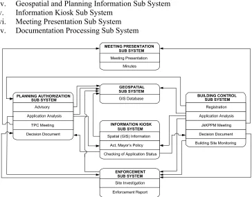
The Computerised Development Control and Approval System which will be implemented by the Planning and Development Control Department, City Hall of Kuala Lumpur, is one of the ICT applications undertaken to facilitate the procedures to control and monitor the city development. The system being developed integrates several sub systems to execute specific
functions. Every sub system interacts with one another by sharing information sources.
(Figure 1). In general, the Development Control and Approval System encompass seven main sub systems, which are:
i. Planning Authorization Sub System
ii. Building Control Sub System
iii. Enforcement Subsystem
iv. Geospatial and Planning Information Sub System
v. Information Kiosk Sub System
vi. Meeting Presentation Sub System
iv. Documentation Processing Sub System
PLANNING AUTHORIZATION SUB SYSTEM Advisory Application Analysis
TPC Meeting Decision Document
BUILDING CONTROL SUB SYSTEM
Registration Application Analysis
JkKPPM Meeting Decision Document Building Site Monitoring MEETING PRESENTATION
SUB SYSTEM Meeting Presentation
Minutes
ENFORCEMENT SUB SYSTEM Site Investigation Enforcement Report
GEOSPATIAL SUB SYSTEM GIS Database
INFORMATION KIOSK SUB SYSTEM Spatial (GIS) Information
Checking of Application Status Act, Mayor’s Policy
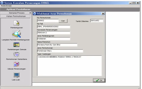
Planning Authorization Sub System
The Planning Authorization Sub System operates to process planning application, beginning from the submission of an application until the Policy Approval or Development Order is issued. To support the processes involved in Planning Authorization, this sub system was designed to encompass six modules as follows:
• Advisory Module
• Registration Module
• Task distribution and LPP Module
• Agenda Module
• Decision Documents Module
• Monitoring Module
This sub system allows user to observe the related policies and spatial information while
evaluating the planning applications and requirements (Figure 2). Apart from saving time
and space, it helps to minimize workload and reduce the use of paper. Besides, the data-sharing concept will minimize overlapping of data storing in the database as well as information processing and thus, increase the quality and productivity of work.
Building Control Sub System
The Building Control Sub System is meant as a support for the building approval process. This sub system begins from the submission of application for building plan approval through the process of producing Certificate for Occupation. The features are similar to the Planning Authorization Sub System, which include graphic and interactive interface and enable interaction between sub systems. This sub system will assist the Building Control Division in managing their activities through the five modules developed:
• Registration Module
• Evaluation of Application Module
• Agenda Module
• Decision AcknowledgementModule
• Monitoring Module
Enforcement Sub System
The Enforcement Sub System assists the Planning and Building Control Department in planning and carrying out enforcement actions. These include generating reports on site investigation, issuing warning notices, implementing control activities and reports on certain decision made by the Planning and Building Control Department. This sub system also helps the public to file complaint and receive feedback from the local authority. It also facilitates the management in acquiring investigation reports faster so as to act in a more effective and timely manner. Four modules were developed for this sub system, namely:
• Enforcement Module
• Planner Module
• Building and Sanitary Module
• Monitoring Module
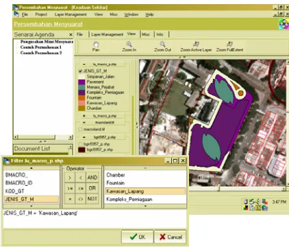
Geospatial and Planning Information Sub System
The Geospatial and Planning Information Sub System (Figure 3) is developed to produce a
complete spatial database along with the attribute data, which recorded the Development Order Approval, Building Order Approval, and Building Occupation Order. This sub system will enable the management to make decision more systematically and rationally. Some advantages of this system are that users can specify the type of information they want to retrieve using the query function based on ‘lot’, ‘road’, ‘section’ or ‘mukim’ identifications. The implementation of this system involves the GIS database design, data collection, data conversion and updating of spatial and attribute data. The GIS developed also provide support in terms of spatial data for the Planning Authorization Sub System, Building Control Sub System, Enforcement Sub System and Presentation Sub System. Therefore, the interface program developed will provide a link with these sub systems. This model also enables other divisions to retrieve any information they need using the provided interface.
Information Kiosk Sub System
The Information Kiosk Sub System is built for internal users as well as the public to gather
information through the Planning and Building Control Department’s web site (Figure 4).
This kiosk provides detail information on Kuala Lumpur, the Planning and Building Control Department as well as Development Control and Enforcement. Through the system, users can retrieve information related to City Hall of Kuala Lumpur apart from obtain various forms provided. The system also allows the City Hall to announce important issues to the public. In general, this sub system operates to provide the following:
• Function for enforcement plan approval decision
• Function for accessing spatial data (GIS web)
• Function for accessing information on planning and building legislation
• Function for accessing application supporting documents
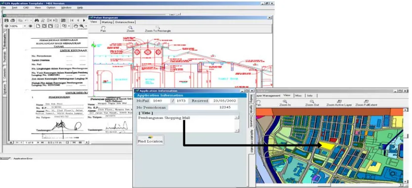
Meeting Presentation Sub System
The Meeting Presentation Sub System enables the smooth progress of a meeting through facilities for displaying related information on development application including plans, GIS related data and other associated information being discussed such as documents, maps and
so forth (Figure 5). Meetings should be able to run smoothly as location plans, site images,
perspective diagrams and proposal plans can be illustrated with a clearer image compared to conventional procedures. Furthermore, the information needed can be retrieved promptly.
Documentation Processing Sub System
The Documentation Processing Sub System is designed to store and retrieve all documents in a more systematic manner. This may solve the problems of storing physical files and locating of files. The documents will be transformed from hardcopy to softcopy and stored in the system database. Hence, user can manage the documents more efficiently and simply as and when the document is needed.
TOWARDS E-SUBMISSION: PROSPECTS AND CHALLENGES
Since the early 1980’s, there have been major breakthroughs in the cost, speed and data storage capacity of computer hardware and software. With computer costs still dropping, with the emerge of powerful portable machines, and with the possibility of massively increased network bandwidths, enabling a larger and larger segment of Kuala Lumpur city dwellers to connect up, the prospects for new types of computer use in problem solving and policy
domains have never been more promising. The application of computerised development
control and approval system will inevitably influence the existing structure and practice of urban planning and management in CHKL. Success or failure in the adoption depends on a variety of human, organizational and technical factors (Yaakup, Johar and Dahlan, 1997).
The implementation of e-submission, however, involves far more than hardware and software
decisions. A critical evaluation should be given priority beforeadopting the implementation
of e-submission. Effective implementation rests on a thorough and systematic evaluation encompassing planning, operational, organizational, institutional, personnel, financial and technical aspects. More research and attention need to be directed toward the organizational and institutional issues.
One of the most important requirements is that the system developed to implement e-submission should cover all the necessary work process involved in development control and approval. Selection of crucial procedures to be computerised will cut cost and time consumed apart from minimizing the process of bureaucracy. Defining of workflow will also avoid overlapping of information processing. The system should also allow continuing process of amendment and updating of information. There is also a need to specify the compatible formats allowed for submission of application and ensure that the system is capable of catering multi-data transfer.
As not all parties are ready for full implementation of e-submission, both electronic as well as manual application should be allowed. For the time being, the development control and approval system should be able to support a counter-based application with stress on the need for submission of digital information regarding each application. In the long run, efforts need to be made to develop the man-power within the organisation as well as educate the public and private entities involved on the requirements for e-submission. E-submission could then be implemented either through the use of internet or ATM-based application. These procedures inevitably need to be supported by legal devices to ensure that all parties are secured of their rights.
well as external users. Establishment of an e-submission monitoring committee should also be considered to help evaluate and validate the integrity and reliability of information submitted.
The system should also provide compatibility to multiple electronic payment methods such as e-transfer, e-debit, e-money, e-cash and so forth as well as conventional payment procedures
i.e. by cash and cheques. Last but not least, the system developed for implementation of
e-submission should also allow for integration with other stand-alone databases apart from
further enhancement to cope with the fast changingtechnology.
CONCLUSION
With the continuous development of ICT, there is a major opportunity for local authorities to use it to manage the allocation of scarce resources in a rapidly changing environment. The quality of urban planning and management can be upgraded when available and valid data are handled in an advanced manner with the aid of computers. The system will be able to support planning and decision-making because it offers relatively quick response on analytical questions and monitoring issues. Some of the important functions include the ability to retrieve information rapidly and efficiently, model different scenarios and evaluate alternative solutions generated by various modeling procedures.
Implementation of e-submission is seen as an important tool in facilitating and accelerating the process of development control and approval in CHKL. However, an important issue in the implementation of e-submission is the overall information management strategy which takes account of data availability, computing capabilities and management requirements. Without well-developed information management strategies, it is likely that major problem will arise in relation to its utilization. There will be mismatches between information needs and data availability as well as between data collection and information processing. The implementation and application of e-submission procedures therefore take a much longer time and costs more to be developed before the application can be demonstrated and evaluated.
Acknowledgement
The authors would like to thank the Kuala Lumpur City Hall and University of Technology Malaysia for allowing and granting permission to present this paper.
References
Adom, R. (1992). Peraturan mengemukakan permohonan perancangan ke Unit Pengekalan dan Seni Bandar, Department of Planning and Building Control, City Hall of Kuala Lumpur.
Baharom, A. and Yusof, I.M. (2001). GIS application in development control process: local
government in Malaysia. Paper presented at Middle State Division of the Association
Hill, T.R. and McConnachie, D. (2001). The role of Geograhical Information Systems in developing planning in South Africa, Third World Planning Review, 23(3): 289-300.
Kerajaan Malaysia (1973). Akta (Perancangan) Bandaraya Kuala Lumpur, 1973, Akta 107, Jabatan Percetakan Negara, Kuala Lumpur.
Kerajaan Malaysia (1976). Akta Perancang Bandar dan Desa 1976, Akta 176, Jabatan Percetakan Negara, Kuala Lumpur.
Mohamad Saib (2002). A vision of local government in the 21st century. Paper presented at
the Seminar on Urban Management: Good Urban Governance, Cyberjaya, 15-16 April, 2002.
Rakodi, C. (2002). Politics and performance: the implication of emerging governance for
urban management approaches and information systems. Proceedings of the Sixth
GISDECO: Governance and the Use of GIS in Developing Country, ITC Enschede, The Netherlands, 15-18 May 2002.
UNCED (1987). Our Common Future, Oxford University Press, Oxford.
Unit Multi Media (2001). Sistem-sistem Teknologi Maklumat dan Komunikasi (ICT) di Dewan Bandaraya Kuala Lumpur, Jabatan Pengurusan Organisasi, Dewan Bandaraya Kuala Lumpur.
Yaakup, A., Johar, F., Sulaiman, S., Hassan, R. and Ibrahim, A.R. (2002). GIS and
Development Control System for Local Authorities in Malaysia. Proceedings of the
Sixth GISDECO: Governance and the Use of GIS in Developing Country, ITC Enschede, The Netherlands, 15-18 May 2002.
Yaakup, A., Johar, F. and Dahlan, N.A. (1997). GIS and decision support systems for local
authorities in Malaysia, in H. Timmermans (ed) Decision Support System in Urban
Planning, E & FN SPON, London, pp. 212-228.
APPLICANT
BAHAGIAN KAWALAN PERANCANGAN (JP&KB)
LAND SURVEYOR JP&KB JKA
JABATAN UKUR KE PEJABAT TANAH DAN GALIAN (WP)
LAND EXCO (PTG/WP) EXCO LAND LAND SURVEYOR
LAND & SURVEY DEPT
LAND & SURVEY DEPT LAND EXCO (PTG/WP) LAND SURVEYOR LAND EXCO(PTG/WP) APPLICANT APPLICANT TECHNICAL COMMITEE TECHNICAL COMMITEE TOWN PLANNING COMMITEE APPLICANT BAHAGIAN KAWALAN BANGUNAN (JP&KB) BAHAGIAN KAWALAN PERANCANGAN (JP&KB) BAHAGIAN KAWALAN PERANCANGAN (JP&KB) BAHAGIAN KAWALAN PERANCANGAN (JP&KB) BAHAGIAN KAWALAN PERANCANGAN (JP&KB) BAHAGIAN KAWALAN PERANCANGAN (JP&KB) BAHAGIAN KAWALAN BANGUNAN (JP&KB) CONSTRUCTION BAHAGIAN KAWALAN APPLICANT Correction & Amendments
FULFILLED DEVELOPMENT ORDER TERMS
TNB JBA LLM LPS
JAS TELEKOM BOMBA DCA
PTG/WP FULFILLED DEVELOPMENT ORDER TERMS
JSTKP JPPPK JKA JP&P
JKA JKA JPB
UNIT
SANITARI JSTKK
Application of C.F.O Layout submission
Technical Requirement
Consider Layout Approval
Layout Plan Approval
Prepare R.S. Plan
R.S. Plan Endorsement
Submission
Conversion and Sub Division
Approval Conversion and Submission Consideration Payment of
Premium Application Conversion and Submission Consideration
Prepare Q.T. Survey Plan
Issuance of Q.T
Final Boundary Survey on Site
Issuance of Final Title Survey Endorsement
Prepare Q.T.
Apply For Development Order
D.O. Processing
Consider D.O. Approval
Issuance of D.O
Technical Review
D.O. Report & Recommendation
APPROVAL
APPROVAL
C onstru ct Taxi & B us St a nd C ons tr uc t Se we r Re ticu lat ion & Sew e r C ons tr uc tion Ro ad & Dr a in F oot pa th s et c. C ar Pa rk Co ns tru cti on Ear thw or k & Pi lin g Ha wk ers St a ll Ce nt er s La n d sc api ng Re fu se Bi n Co lle cti on C e nt re San itar y Sy st e m LAYOUT APPROVAL STAGEDEVELOPMENT ORDER APPROVAL STAGES
BUILDING PLAN & CERTIFICATION OF OCCUPATION APPROVAL STAGES
SUBDIVISION AND CHANGE OF LAND USE STAGE