Article
1
AutoCloud+, a “universal” physical and statistical
2
model-based 2D spatial topology-preserving
3
software toolbox for cloud/cloud-shadow
4
detection in multi-sensor single-date Earth
5
observation multi-spectral imagery eligible for
6
systematic ESA EO Level 2 product generation
7
Andrea Baraldi 1,2,* and Dirk Tiede 1
8
1 Department of Geoinformatics – Z_GIS, University of Salzburg, Schillerstr. 30, 5020 Salzburg,
9
Austria; [email protected]
10
2 Italian Space Agency (ASI), Via del Politecnico, 00133 Rome RM, Italy.
11
* Correspondence: [email protected]; Tel.: +39-329-2648110
12
13
Abstract: The European Space Agency (ESA) defines as Earth observation (EO) Level 2
14
information product a single-date multi-spectral (MS) image corrected for atmospheric,
15
adjacency and topographic effects, stacked with its data-derived scene classification map
16
(SCM), whose thematic map legend includes quality layers cloud and cloud-shadow. ESA EO
17
Level 2 product generation is an inherently ill-posed computer vision (CV) problem never
18
accomplished to date in operating mode by any EO data provider at the ground segment.
19
Herein, it is considered: (I) necessary not sufficient pre-condition for the yet-unaccomplished
20
dependent problems of semantic content-based image retrieval (SCBIR) and
semantics-21
enabled information/knowledge discovery (SEIKD) in multi-source EO big data cubes. (II)
22
Synonym of EO Analysis Ready Data (ARD) format. (III) Equivalent to a horizontal policy for
23
background developments in Space Economy 4.0. In compliance with the GEO-CEOS Quality
24
Assurance Framework for EO Calibration/Validation guidelines, to contribute toward filling
25
an analytic and pragmatic information gap from multi-sensor EO big data to timely,
26
comprehensive and operational EO value-adding information products and services, this
27
work presents an innovative AutoCloud+ CV software toolbox for cloud and cloud-shadow
28
quality layer detection in ESA EO Level 2 product. In vision, spatial information dominates
29
color information. Inspired by this true-fact, the inherently ill-posed AutoCloud+ CV
30
software was conditioned, designed and implemented to be “universal”, meaning fully
31
automated (no human-machine interaction is required), near real-time, robust to changes in
32
input data and scalable to changes in MS imaging sensor’s spatial and spectral resolution
33
specifications.
34
Keywords: artificial intelligence; color naming; color constancy; cognitive science; computer
35
vision; object-based image analysis (OBIA); physical and statistical data models; radiometric
36
calibration; semantic content-based image retrieval; spatial topological and spatial
non-37
topological information components.
38
39
40
Acronyms
41
AI: Artificial Intelligence
42
AI4DIAS: Artificial Intelligence for Data and Information Access Services (at the ground
43
segment)
44
AI4Space: Artificial Intelligence for Space (segment)
45
ARD: Analysis Ready Data (format)
46
ATCOR: Atmospheric/Topographic Correction commercial sofwtare product
47
AVHRR: Advanced Very High Resolution Radiometer
48
BC: Basic Color
49
BIVRFTAB: Bivariate Frequency Table
50
Cal: Calibration
51
Cal/Val: Calibration and Validation
52
CBIR: Content-Based Image Retrieval
53
CEOS: Committee on Earth Observation Satellites
54
CESBIO: Centre d'Etudes Spatiales de la Biosphère
55
CFMask: C (programming language version of ) Function of Mask
56
CLC: CORINE Land Cover (taxonomy)
57
CNES: Centre national d'études spatiales
58
CNN: Convolutional Neural Network
59
CORINE: Coordination of Information on the Environment
60
CV: Computer Vision
61
DCNN: Deep Convolutional Neural Network
62
DEM: Digital Elevation Model
63
DIAS: Data and Information Access Services
64
DLR: Deutsches Zentrum für Luft- und Raumfahrt (German Aerospace Center)
65
DN: Digital Number
66
DP: Dichotomous Phase (in the FAO LCCS taxonomy)
67
DRIP: Data-Rich, Information-Poor (syndrome)
68
EO: Earth Observation
69
EO-IU: EO Image Understanding
70
EO-IU4SQ: EO Image Understanding for Semantic Querying
71
ESA: European Space Agency
72
FAO: Food and Agriculture Organization
73
FIEOS: Future Intelligent EO imaging Satellites
74
FMask: Function of Mask
75
GEO: Intergovernmental Group on Earth Observations
76
GEOSS: Global EO System of Systems
77
GIGO: Garbage In, Garbage Out principle of error propagation
78
GIS: Geographic Information System
79
GIScience: Geographic Information Science
80
GUI: Graphic User Interface
81
IGBP: International Global Biosphere Programme
82
IU: Image Understanding
83
LAI: Leaf Area Index
84
LC: Land Cover
85
LCC: Land Cover Change
86
LCCS: Land Cover Classification System (taxonomy)
87
LCLU: Land Cover Land Use
88
LEDAPS: Landsat Ecosystem Disturbance Adaptive Processing System
89
MAACS: Multisensor Atmospheric Correction and Cloud Screening
90
MAJA: Multisensor Atmospheric Correction and Cloud Screening
(MACCS)-91
Atmospheric/Topographic Correction (ATCOR) Joint Algorithm
92
mDMI: Minimally Dependent and Maximally Informative (set of quality indicators)
93
MHP: Modular Hierarchical Phase (in the FAO LCCS taxonomy)
94
MIR: Medium InfraRed
95
MODIS: Moderate Resolution Imaging Spectroradiometer
96
Preprints (www.preprints.org) | NOT PEER-REVIEWED | Posted: 28 August 2018 doi:10.20944/preprints201808.0352.v2
MS: Multi-Spectral
97
MSI: (Sentinel-2) Multi-Spectral Instrument
98
NASA: National Aeronautics and Space Administration
99
NIR: Near InfraRed
100
NLCD: National Land Cover Data
101
NOAA: National Oceanic and Atmospheric Administration
102
NP: Non-Polynomial
103
OBIA: Object-Based Image Analysis
104
OGC: Open Geospatial Consortium
105
OP: Outcome (product) and Process
106
OP-Q2I: Outcome and Process Quantitative Quality Index
107
QA4EO: Quality Accuracy Framework for Earth Observation
108
Q2I: Quantitative Quality Indicator
109
RGB: monitor-typical Red-Green-Blue data cube
110
RMSE: Root Mean Square Error
111
RS: Remote Sensing
112
RTD: Research and Technological Development
113
SCBIR: Semantic Content-Based Image Retrieval
114
SCM: Scene Classification Map
115
SEIKD: Semantics-Enabled Information/Knowledge Discovery
116
Sen2Cor: Sentinel 2 (atmospheric) Correction Prototype Processor
117
SIAM™: Satellite Image Automatic Mapper™
118
STRATCOR: Stratified Topographic Correction
119
SURF: Surface Reflectance
120
TIR: Thermal InfraRed
121
TM (superscript): (non-registered) Trademark
122
TMask: Temporal Function of Mask
123
TOA: Top-Of-Atmosphere
124
TOARF: TOA Reflectance
125
UAV: Unmanned Aerial Vehicle
126
UML: Unified Modeling Language
127
USGS: US Geological Survey
128
Val: Validation
129
VAPS: Value-Adding information Products and Services
130
VQ: Vector Quantization
131
WGCV: Working Group on Calibration and Validation
132
1. Introduction
133
Radiometric calibration (Cal) is the process of transforming remote sensing (RS) sensory
134
data, consisting of non-negative dimensionless digital numbers (DNs, with DN ≥ 0) provided
135
with no physical meaning, into a physical variable provided with a community-agreed
136
radiometric unit of measure, such as top-of-atmosphere reflectance (TOARF), surface
137
reflectance (SURF) or surface albedo values in range [0.0, 1.0] [1-3].
138
To cope with the five Vs characterizing big data analytics, specifically, volume, variety,
139
veracity, velocity and value [4], radiometric Cal of Earth observation (EO) big data is considered
140
mandatory by the intergovernmental Group on Earth Observations (GEO)-Committee on
141
Earth Observation Satellites (CEOS) Quality Accuracy Framework for Earth Observation
142
(QA4EO) Calibration/Validation (Cal/Val) guidelines [3]. In agreement with the
yet-143
unaccomplished visionary goal of a GEO’s implementation plan for years 2005-2015 of a Global
144
Earth Observation System of Systems (GEOSS) [5], the ambitious goal of the GEO-CEOS
145
QA4EO Cal/Val guidelines is systematic transformation of EO big data cubes into timely,
146
Despite being considered a well-known “prerequisite for physical model-based analysis of
148
airborne and satellite sensor measurements in the optical domain” [1], EO data radiometric Cal
149
is largely oversighted in the RS common practice. A lack of EO input data Cal requirements
150
means that statistical model-based data analytics and inductive learning-from-data algorithms
151
are dominant in the RS community, including (geographic) object-based image analysis
152
(GEOBIA) applications [6, 7] in the domain of geographic information science (GIScience). On
153
the one hand, statistical model-based and inductive learning-from-data algorithms require as
154
input DNs provided with no physical meaning. On the other hand, inductive
learning-from-155
data algorithms are inherently semi-automatic and site-specific [2]. In practice, they require no
156
radiometric Cal data pre-processing, but they typically gain in robustness when input with
157
radiometrically calibrated data.
158
In compliance with the GEO-CEOS QA4EO Cal/Val requirements and with the GEO’s
159
visionary goal of a GEOSS, the European Space Agency (ESA) has recently defined an ESA EO
160
Level 2 information product as follows [8, 9].
161
(i) A single-date multi-spectral (MS) image, radiometrically corrected for atmospheric,
162
adjacency and topographic effects,
163
(ii) stacked with its data-derived scene classification map (SCM), whose general-purpose,
164
user- and application-independent thematic map legend includes quality layers cloud and
165
cloud-shadow,
166
(iii) to be systematically generated at the ground segment, automatically (without
human-167
machine interaction) and in near real-time.
168
169
Table 1. Non-standard general-purpose, user- and application-independent ESA EO Level 2
170
SCM legend adopted by the sensor-specific Sentinel 2 (atmospheric, adjacency and
171
topographic) Correction (Sen2Cor) Prototype Processor [8, 9], developed and distributed
free-172
of-cost by ESA to be run on user side.
173
174
175
Table 2. Standard general-purpose, user- and application-independent ESA Level 2 SCM
176
legend proposed in [10-12]. “Augmented” 3-level 8-class FAO LCCS Dichotomous Phase (DP)
177
taxonomy (identified as classes A11 to B48) + quality layers Cloud and Cloud-shadow + Others
178
= 8 land cover (LC) classes + 2 LC classes (Cloud-shadow, Others) + 1 non-LC class (Cloud).
179
Preprints (www.preprints.org) | NOT PEER-REVIEWED | Posted: 28 August 2018 doi:10.20944/preprints201808.0352.v2
180
Unlike the non-standard ESA EO Level 2 SCM legend adopted by the Sentinel 2 imaging
181
sensor-specific (atmospheric, adjacency and topographic) Correction Prototype Processor
182
(Sen2Cor), developed by ESA and distributed free-of-cost to be run on user side [8, 9], see Table
183
1, an alternative ESA EO Level 2 SCM legend proposed in [10-12], shown in Table 2, is selected
184
equal to an “augmented” 3-level 9-class Dichotomous Phase (DP) taxonomy of the Food and
185
Agriculture Organization of the United Nations (FAO) – Land Cover Classification System
186
(LCCS) [13], see Figure 1. Such an “augmented” land cover (LC) class taxonomy in the 4D
187
geospatial-temporal scene-domain encompasses the standard fully-nested 3-level 8-class FAO
188
LCCS-DP legend, , see Figure 1, in addition to a thematic layer “other” or “rest of the world”,
189
which includes quality layers cloud and cloud-shadow. In traditional EO image classification
190
system design and implementation requirements [14], the presence of output class “unknown”
191
is considered mandatory to cope with uncertainty in inherently equivocal
information-as-data-192
interpretation (classification) tasks [15].
193
194
Figure 1. Two-stage fully-nested FAO Land Cover Classification System (LCCS) taxonomy
195
[13]. The first-stage fully-nested 3-level 8-class FAO LCCS Dichotomous Phase (DP) taxonomy
196
is general-purpose, user- and application-independent. It consists of a sorted set of 3
197
dichotomous layers: (i) vegetation versus non-vegetation, (ii) terrestrial versus aquatic, and
198
(iii) managed versus natural or semi-natural. These 3 dichotomous layers deliver as output the
199
aquatic) Vegetated Areas. (A12) Natural and Semi-Natural Terrestrial Vegetation. (A23)
201
Cultivated Aquatic or Regularly Flooded Vegetated Areas. (A24) Natural and Semi-Natural
202
Aquatic or Regularly Flooded Vegetation. (B35) Artificial Surfaces and Associated Areas. (B36)
203
Bare Areas. (B47) Artificial Waterbodies, Snow and Ice. (B48) Natural Waterbodies, Snow and
204
Ice. The general-purpose user- and application-independent 3-level 8-class FAO LCCS-DP
205
taxonomy is preliminary to a second-stage FAO LCCS Modular Hierarchical Phase (MHP)
206
taxonomy, consisting of a battery of user- and application-specific one-class classifiers,
207
equivalent to one-class grammars (syntactic classifiers) [16].
208
Shown in Figure 1, the standard two-phase fully-nested FAO LCCS hierarchy consists a
209
first-stage fully-nested general-purpose, user- and application-independent 3-level 8-class
210
FAO LCCS-DP legend, preliminary to a second-stage application-dependent and user-specific
211
FAO LCCS Modular Hierarchical Phase (MHP) taxonomy, consisting of a hierarchical (deep)
212
battery of one-class classifiers [13]. The standard first-stage 3-level 8-class FAO LCCS-DP
213
hierarchy is “fully nested”. It comprises three dichotomous LC class-specific information
214
layers, equivalent to a world ontology, world model or mental model of the world [10, 13,
16-215
21]: DP Level 1 – Vegetation versus non-vegetation, DP Level 2 – Terrestrial versus aquatic and
216
DP Level 3 – Managed versus natural or semi-natural. In recent years, the two-phase FAO
217
LCCS taxonomy has become increasingly popular [22]. One reason of its popularity is that the
218
FAO LCCS hierarchy is “fully nested” while alternative LC class hierarchies, such as the
219
Coordination of Information on the Environment (CORINE) Land Cover (CLC) taxomony [23],
220
the U.S. Geological Survey (USGS) Land Cover Land Use (LCLU) taxonomy by J. Anderson
221
[24], the International Global Biosphere Programme (IGBP) DISCover Data Set Land Cover
222
Classification System [25] and the EO Image Librarian LC class legend [26], start from a Level
223
1 taxonomy which is already multi-class. In a hierarchical EO image understanding (EO-IU)
224
system architecture submitted to a garbage in, garbage out (GIGO) information principle,
225
synonym of error propagation through an information processing chain, the fully-nested
two-226
phase FAO LCCS hierarchy makes explicit the full dependence of high-level LC class estimates,
227
performed by any high-level (deep) LCCS-MHP data processing module, on the operational
228
quality (in accuracy, efficiency, robustness, etc.) of lower-level LCCS modules, starting from
229
the initial FAO LCCS-DP Level 1 vegetation/non-vegetation information layer whose relevance
230
in thematic mapping accuracy (vice versa, in error propagation) becomes paramount for all
231
subsequent LCCS layers. The GIGO commonsense principle applied to hierarchical semantic
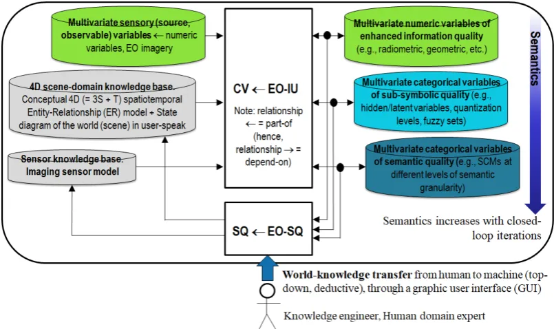
232
dependence is neither trivial nor obvious to underline [27]. On the one hand, it agrees with a
233
minor portion of the RS literature where supervised data learning classification of EO image
234
datasets at continental or global spatial extent into binary LC class vegetation/non-vegetation
235
is considered very challenging [28]. On the other hand, it is at odd with the RS mainstream,
236
where the semantic information gap from sub-symbolic EO data to multi-class LC taxonomies
237
is typically filled in one step, implemented as a supervised data learning classifier [29, 30], e.g.,
238
a support vector machine, random forest or deep convolutional neural network (DCNN) [31],
239
which is equivalent to an unstructured black box [27], inherently semi-automatic and
site-240
specific [2] and whose opacity contradicts the well-known engineering principles of
241
modularity, regularity and hierarchy typical of scalable systems [32]. "No Free Lunch”
242
theorems have shown that inductive learning-from-data algorithms cannot be universally
243
good [33, 34].
244
Over land surfaces of the Earth, the global cloud cover is approximately 66% [35]. In the
245
ESA EO Level 2 product definition, cloud and cloud-shadow quality layer requirements
246
specification accounts for a well-known prerequisite of clear-sky multi-temporal EO image
247
compositing and understanding (classification) solutions proposed by the RS community,
248
where accurate masking of cloud and cloud-shadow phenomena is considered necessary not
249
sufficient pre-condition [9, 10, 36-56]. Intuitively, in single-date and multi-temporal MS image
250
analysis, cloud and cloud-shadow preliminary detection is a relevant problem, because
251
unflagged cloud and cloud-shadow phenomena may be mapped onto erroneous LC classes or
252
Preprints (www.preprints.org) | NOT PEER-REVIEWED | Posted: 28 August 2018 doi:10.20944/preprints201808.0352.v2
false LC change (LCC) occurrences. Noteworthy, cloud/cloud-shadow detection is a typical
253
example of physical model-based cause-effect relationship, expected to be very difficult to
254
solve by inductive machine learning-from-data algorithms, such as increasingly popular
255
DCNNs [31], suitable for learning complex correlations between input and output features, but
256
capable of no inherent representation of causality [27, 57], in agreement with the well-known
257
dictum that correlation does not imply causation and vice versa [10, 16, 27, 30, 57, 58].
258
In the last decade, many different cloud/cloud-shadow detection algorithms were
259
presented in the RS literature to run either on a single-date MS image or on an MS image
time-260
series, typically acquired by either one EO spaceborne/airborne MS imaging sensor or a single
261
family (e.g., Landsat) of MS imaging sensors [9, 10, 36-53]. To be accomplished in operating
262
mode at the ground segment (midstream) by EO data providers in support of the downstream
263
sector in an era of Space Economy 4.0 [59], systematic radiometric Cal of source
multi-264
angular MS big image data cubes [1, 3, 10, 60-62], encompassing either single-date or
multi-265
temporal cloud and cloud-shadow detection as a necessary not sufficient pre-condition, is
266
regarded by the RS community as an open problem to date [54-56].
267
To overcome conceptual limitations and well-known failure modes of existing cloud and
268
cloud-shadow detection algorithms [37, 40, 54-56], such as the single-date open source
269
Function of Mask (FMask) algorithm [51, 52], the free-of-cost single-date ESA Sen2Cor software
270
toolbox to be run on user side [8, 9, 37] and the multi-date Multisensor Atmospheric Correction
271
and Cloud Screening (MACCS)-Atmospheric/Topographic Correction (ATCOR) Joint
272
Algorithm (MAJA) developed by the Centre national d'études spatiales (CNES)/ Centre
273
d'Etudes Spatiales de la Biosphère (CESBIO)/ Deutsches Zentrum für Luft- und Raumfahrt
274
(German Aerospace Center, DLR) [39-41], which incorporates capabilities of the ATCOR
275
commercial software toolbox [63-66], this work presents an innovative AutoCloud+ computer
276
vision (CV) software toolbox for cloud and cloud-shadow quality layer detection, suitable for
277
systematic ESA EO Level 2 product generation at the ground segment [36, 60, 67]), in
278
compliance with the GEO-CEOS QA4EO Cal/Val requirements [3].
279
Synonym of inherently ill-posed scene-from-image reconstruction and understanding [10,
280
20, 68, 69]), vision is a cognitive (information-as-data-interpretation) process [15], encompassing
281
both biological vision and CV, where CV is subset-of artificial (general) intelligence (AI) [70-74],
282
i.e., AI ⊃ CV. In vision, spatial information dominates color information [20]. This
283
unquestionable true-fact is familiar to all human beings wearing sunglasses: in perceptual
284
terms, human panchromatic and chromatic visions are nearly as effective [10]. Based on this
285
observation, an inherently ill-posed AutoCloud+ CV subsystem was constrained, designed and
286
implemented to be “universal” in operating mode, i.e., automated (no human-machine
287
interaction is required to run), near real-time, robust to changes in input data and scalable to
288
cope with changes in MS imaging sensor’s spatial and spectral resolution specifications.
289
The rest of this paper is organized as follows. Provided with a relevant survey value,
290
Section 2 reviews the interdisciplinary problem background of systematic ESA EO Level 2
291
product generation, regarded as necessary not sufficient pre-condition for a
yet-292
unaccomplished GEOSS development. Related works in cloud/cloud-shadow detection are
293
critically revised in Section 3. Adopted AutoCloud+ methods and materials are proposed in
294
Section 4 and 5 respectively. Collected results are presented in Section 6 and discussed in
295
Section 7. Conclusions are reported in Section 8.
296
2. Problem background
297
Featuring a relevant survey value, this Section aims at providing a critical review of the
298
interdisciplinary problem background of systematic ESA EO Level 2 product generation.
299
According to our original working hypothesis, to be regarded as our first original contribution,
300
systematic ESA EO Level 2 product generation is postulated as necessary not sufficient
pre-301
condition for a yet-unaccomplished GEOSS development, in agreement with the GEO-CEOS
302
highlights the several degrees of novelty of the ESA EO Level 2 product definition (refer to
304
Section 1) in comparison with, for example, alternative EO Analysis Ready Data (ARD) format
305
definitions proposed by the RS community. Next, as our third original contribution, structural
306
limitations in system design of existing open source or commercial software products for EO
307
image radiometric Cal (correction) are underlined, to be overcome by an alternative system
308
architecture.
309
310
Figure 2. Solar illumination geometries and viewpoint geometries in spaceborne and airborne
311
EO image acquisition.
312
To successfully cope with the five Vs of EO big data analytics, specifically, volume, variety,
313
veracity, velocity and value [4], multi-sensor analysis of multi-temporal multi-angular EO
314
sensory data cubes depends upon the ability to distinguish between relevant changes and
no-315
changes occurring at the Earth surface through time [61, 62]. Necessary not sufficient
pre-316
condition for EO big data transformation into timely, comprehensive and operational EO
data-317
derived VAPS, expected by GEO to be pursued by a GEOSS never accomplished to date [5], is
318
radiometric Cal, considered mandatory by the GEO-CEOS QA4EO Cal/Val requirements [3]. In
319
short, radiometric Cal guarantees EO sensory data interoperability (consistency,
320
“normalization”) through time, geographic space and sensors. In greater detail, the capability
321
to detect and quantify change/no-change in terms of either qualitative (nominal, categorical)
322
Earth surface variables, such as LC classes belonging to a finite and discrete LC class taxonomy
323
(legend), or quantitative (numeric) Earth surface variables, such as biophysical variables, e.g.,
324
leaf area index (LAI), biomass, etc. [75], depends on the radiometric Cal of EO sensory data,
325
equivalent to non-negative dimensionless DNs ≥ 0, provided with no physical meaning and
326
typically affected at sensor-level by ever-varying atmospheric conditions, solar illumination
327
conditions, spaceborne/airborne viewing geometries and Earth surface topography, into a
328
physical variable provided with a community-agreed radiometric unit of measure, such as
329
SURF or surface albedo values in range [0, 1] [1-3]. Solar illumination conditions are typically
330
parameterized by metadata Cal parameters, such as image acquisition time, solar
331
exoatmospheric irradiance, solar zenith angle and solar azimuth angle, see Figure 2. Sensor
332
viewing characteristics are typical metadata Cal parameters, such as sensor zenith angle and
333
sensor azimuth angle, see Figure 2. Atmospheric conditions are described by categorical
334
variables, such as aerosol type, haze, cloud and cloud-shadow, and by numeric variables, such
335
as water vapor, temperature and aerosol optical thickness (AOT) [61, 62]. Finally, Earth surface
336
Preprints (www.preprints.org) | NOT PEER-REVIEWED | Posted: 28 August 2018 doi:10.20944/preprints201808.0352.v2
geometries must be inferred from ancillary data, such as a digital elevation model (DEM), in
337
combination with solar and viewing conditions [76], see Figure 2.
338
Adopted by different scientific disciplines, such as machine learning-from-data [30], AI as
339
superset-of CV [70], i.e., AI ⊃ CV, and RS [2, 10], popular synonyms of deductive inference are
340
top-down inference, prior knowledge-based inference, learning-by-rule inference and physical
341
model-based inference. Synonyms of inductive inference are bottom-up inference,
learning-342
from-data inference, learning-from-examples inference and statistical model-based inference.
343
On the one hand, non-calibrated sensory data, provided with no physical meaning, can
344
be investigated by statistical data models and inductive inference algorithms, exclusively. On
345
the other hand, although they do not require physical variables as input, statistical data models
346
and inductive learning-from-data algorithms can benefit from input data Cal in terms of
347
augmented robustness to changes in the input data set acquired through time, space and
348
sensors. On the contrary, radiometrically calibrated data, provided with a physical meaning,
349
can be interpreted by either inductive, deductive (physical model-based) or hybrid (combined
350
deductive and inductive) inference algorithms. Although it is considered a well-known
351
“prerequisite for physical model-based (and hybrid) analysis of airborne and satellite sensor
352
measurements in the optical domain” [1, 10, 60-62], EO data Cal is largely neglected in the RS
353
common practice. For example, in major portions of the RS literature, including the GEOBIA
354
sub-domain of GIScience [6, 7], no reference to radiometric Cal issues is found. This lack of
355
input EO data Cal requirements proves that, to date, EO image analytics mainly consists of
356
inductive learning-from-data algorithms, starting from scratch because no a priori physical
357
knowledge is exploited in addition to data. This is in contrast with biological cognitive systems,
358
where “there is never an absolute beginning” [77], because a priori genotype provides initial
359
conditions (that reflect properties of the world, embodied through evolution, based on
360
evolutionary experience) to learning-from-examples phenotype, according to a hybrid
361
inference paradigm, where phenotype explores the neighborhood of genotype in a solution
362
space [10, 71]. Hybrid inference combines deductive and inductive inference to take advantage
363
of each and overcome their shortcomings [2]. Inductive inference is typically semi-automatic
364
and site-specific [2]. Deductive inference is static (non-adaptive to data) and typically lacks
365
flexibility to transform ever-varying sensory data (sensations) into stable percepts (concepts)
366
in a world model [10, 20, 78, 79].
367
In compliance with the GEO-CEOS QA4EO Cal/Val requirements and the visionary goal
368
of a GEOSS ([5]), ESA has recently provided an original ESA EO Level 2 information product
369
definition, refer to Section 1 [8, 9]. The ESA EO Level 2 product definition is non-trivial.
370
Noteworthy, it is more restrictive than the National Aeronautics and Space Administration
371
(NASA) EO Level 2 product definition of “a data-derived geophysical variable at the same
372
resolution and location as Level 1 source data” [80]. According to the standard Unified
373
Modeling Language (UML) for graphical modeling of object-oriented software [81], where
374
symbol ‘→’ denotes relationship part-of pointing from the supplier to the client (vice versa, it
375
would denote relationship depend-on), not to be confused with relationship subset-of, whose
376
symbol is ‘⊃’, meaning specialization with inheritance from the superset to the subset,
377
dependence relationship ‘NASA EO Level 2 product → ESA EO Level 2 product’ holds true,
378
see Figure 3. It means that a NASA EO Level 2 product can be accomplished although no ESA
379
EO Level 2 product exists, whereas the vice versa does not hold.
380
Figure 3. In agreement with thestandard Unified Modeling Language (UML) for graphical
382
modeling of object-oriented software ([81]), relationship part-of, denoted with symbol ‘→’
383
pointing from the supplier to the client, should not to be confused with relationship subset-of,
384
‘⊃’, meaning specialization with inheritance from the superset to the subset [81]. A NASA EO
385
Level 2 product is defined as “a data-derived geophysical variable at the same resolution and
386
location as Level 1 source data” [80]. Herein, it is considered part-of an ESA EO Level 2 product
387
defined as [8, 9]: (a) a single-date multi-spectral (MS) image whose digital numbers (DNs) are
388
radiometrically corrected into surface reflectance (SURF) values for atmospheric, adjacency
389
and topographic effects, stacked with (b) its data-derived general-purpose, user- and
390
application-independent scene classification map (SCM), whose thematic map legend includes
391
quality layers cloud and cloud-shadow. In this paper, ESA EO Level 2 product is regarded as
392
an information primitive to be accomplished by Artificial Intelligence for the Space segment
393
(AI4Space), such as in future intelligent small satellite constellations, rather than at the ground
394
segment in an AI for data and information access services (AI4DIAS) framework. In this
395
graphical representation, additional acronyms of interest are computer vision (CV), whose
396
special case is EO image understanding (EO-IU) in operating mode, semantic content-based
397
image retrieval (SCBIR) [10, 82-87], semantics-enabled information/knowledge discovery
398
(SEIKD), where SCIR + SEIKD is considered synonym of AI4DIAS, and Global Earth
399
Observation System of Systems (GEOSS), defined by the Group on Earth Observations [5]. Our
400
working hypothesis postulates that ‘NASA EO Level 2 product → ESA EO Level 2 product =
401
AI4Space ⊂ EO-IU in operating mode ⊂ CV → [EO-SCBIR + SEIKD = AI4DIAS] → GEOSS’. It
402
means that GEOSS, whose part-of are the still-unsolved (open) problems of SCBIR and SEIKD,
403
cannot be achieved until the necessary not sufficient pre-condition of CV in operating mode,
404
specifically, systematic ESA EO Level 2 product generation, is accomplished in advance.
405
Encompassing both biological vision and CV, vision is synonym of scene-from-image
406
reconstruction and understanding. Vision is a cognitive (information-as-data-interpretation)
407
problem [15] very difficult to solve because: (i) non-polynomial (NP)-hard in computational
408
complexity [88, 89], (ii) inherently ill-posed in the Hadamard sense [90], i.e., vision admits no
409
solution, multiple solutions or, if the solution exists, the solution's behavior changes
410
continuously with the initial conditions [20, 68]. Vision is inherently ill-posed because affected
411
by: (I) a 4D-to-2D data dimensionality reduction from the scene-domain to the image-domain,
412
e.g., responsible of occlusion phenomena, and (II) a semantic information gap from
ever-413
varying sub-symbolic sensory data (sensations) in the physical world to stable symbolic
414
percepts in the mental model of the physical world (modeled world, world ontology, world
415
model) [10, 16-21]. Since it is inherently ill-posed, vision requires a priori knowledge in addition
416
to sensory data to become better posed for numerical solution [30]. If the aforementioned
417
working hypothesis holds true, then the complexity of SCBIR + SEIKD is not inferior to the
418
complexity of vision, acknowledged to be inherently ill-posed and NP-hard. To make the
419
inherently-ill-posed CV problem better conditioned for numerical solution, a CV system is
420
required to comply with human visual perception. In other words, a CV system is constrained
421
to include a computational model of human vision, i.e., ‘Human vision → CV’. Hence,
422
Preprints (www.preprints.org) | NOT PEER-REVIEWED | Posted: 28 August 2018 doi:10.20944/preprints201808.0352.v2
dependence relationship: ‘Human vision → CV ⊃ EO-IU in operating mode ⊃ NASA EO Level
423
2 product → ESA EO Level 2 product → [EO-SCBIR + SEIKD = AI4DIAS] → GEOSS’ is our
424
working hypothesis.
425
An improved (“augmented”) and more restrictive ESA EO Level 2 product definition
426
could be defined to account for bidirectional reflectance distribution function (BRDF) effect
427
correction, in addition to atmospheric, topographic and adjacency effects correction, to model
428
surface anisotropy in multi-temporal multi-angular EO image data cubes [2, 61, 62, 66, 91-94].
429
A surface that reflects the incident energy equally in all directions is said to be Lambertian,
430
where reflectance is invariant with respect to illumination and viewing conditions, see Figure
431
2. On the contrary, a surface is said to be anisotropic when its reflectance varies with respect
432
to illumination and/or viewing geometries. These changes are driven by the optical and
433
structural properties of the surface material. In other words, in EO image pre-processing
434
(enhancement) for radiometric Cal, BRDF effect correction is LC class-specific [61, 62, 66,
91-435
94]. The LC class-specific task of BRDF correction is to derive, for non-Lambertian surfaces,
436
spectral albedo (bi-hemispherical reflectance, BHR) values, defined over all directions [2, 66,
437
91-94], from either SURF or TOARF values where the Lambertian surface assumption holds
438
[63-66, 91].
439
Our first original contribution is to consider an ESA EO Level 2 information product a
440
baseline information unit (information primitive) whose systematic generation is of
441
paramount importance to contribute toward filling an analytic and pragmatic information gap
442
from multi-sensor, multi-temporal and multi-angular EO big image data cubes into timely,
443
comprehensive and operational EO data-derived VAPS, in compliance with the
yet-444
unaccomplished visionary goal of a GEOSS [3, 5]. In Figure 3, our working hypothesis
445
postulates that systematic ESA EO Level 2 product generation is an inherently ill-posed CV
446
problem, where CV ⊃ EO-IU, whose solution in operating mode is necessary not sufficient
pre-447
condition for the yet-unaccomplished dependent problems of semantic content-based image
448
retrieval (SCBIR) [10, 82-87] and semantics-enabled information/knowledge discovery (SEIKD)
449
in large-scale EO image data cubes, with SCBIR + SEIKD considered synonym of artificial
450
intelligence for data and information access services (AI4DIAS), where AI4DIAS is part-of a
451
yet-unaccomplished GEOSS. The closed-loop AI4DIAS system architecture, suitable for
452
semantics-enabled incremental learning [10, 87], is sketched in Figure 4 [10].
453
454
Figure 4. Artificial intelligence (AI) for data and information access services (AI4DIAS),
455
semantic querying (EO-IU4SQ) system architecture. At the Marr level of system
457
understanding known as system design (architecture) [69], AI4DIAS is sketched as a
closed-458
loop EO-IU4SQ system architecture, suitable for incremental semantic learning. It comprises a
459
primary (dominant, necessary not sufficient) hybrid (combined deductive and inductive)
460
feedback (provided with feedback loops) EO-IU subsystem in closed-loop with a secondary
461
(dominated) hybrid feedback EO-SQ subsystem. Subset-of a computer vision (CV) system,
462
where CV ⊃ EO-IU, the EO-IU subsystem is required to be automatic (no human-machine
463
interaction is required by the CV system to run) and near real-time to provide the EO-SQ
464
subsystem with useful information products, including thematic maps of symbolic quality,
465
such as single-date ESA EO Level 2 Scene Classification Map (SCM) considered necessary not
466
sufficient pre-condition to semantic querying, synonym of semantics-enabled
467
information/knowledge discovery (SEIKD) in massive multi-source EO image databases. The
468
EO-SQ subsystem is provided with a graphic user interface (GUI) to streamline: (i) top-down
469
knowledge transfer from-human-to-machine of an a priori mental model of the 4D
geospatial-470
temporal real-world, (ii) high-level user- and application-specific EO semantic content-based
471
image retrieval (SCBIR) operations. Output products generated by the closed-loop EO-IU4SQ
472
system are expected to monotonically increase their value-added with closed-loop iterations,
473
according to Bayesian updating where Bayesian inference is applied iteratively [95, 96]: after
474
observing some evidence, the resulting posterior probability can be treated as a prior
475
probability and a new posterior probability computed from new evidence. One of Marr’s
476
legacies is the notion of computational constraints required to make the typically ill-posed
477
non-polynomial (NP)-hard problem of intelligence, encompassing vision [89], better
478
conditioned for numerical solution [30]. Marr’s computational constraints that reflect
479
properties of the world are embodied through evolution, equivalent to genotype [71], into the
480
human visual complex system, structured as a hierarchical network of networks with feedback
481
loops [89, 97-102, 181]). Marr’s computational constraints are Bayesian priors in a Bayesian
482
inference approach to vision [69, 95, 103], where ever-varying sensations (sensory data) are
483
transformed into stable percepts (concepts) about the world in a world model [20], to perform
484
successfully in the world [15].
485
To justify our working hypothesis sketched in Figure 3, specifically, ‘Human vision → CV
486
⊃ EO-IU in operating mode ⊃ NASA EO Level 2 product → ESA EO Level 2 product →
[EO-487
SCBIR + SEIKD = AI4DIAS] → GEOSS’, let us introduce, first, the definition proposed for an
488
EO-IU system to be considered in operating mode and, second, the background knowledge of
489
vision in the multidisciplinary domain of cognitive science [70-74].
490
Based on scientific literature [10-12, 60, 78, 79, 104], a CV ⊃ EO-IU system is defined in
491
operating mode if and only if it scores “high” in every index of a minimally dependent and
492
maximally informative (mDMI) set of EO outcome and process (OP) quantitative quality
493
indicators (Q2Is), to be community-agreed upon to be used by members of the RS community,
494
in agreement with the GEO-CEOS QA4EO Cal/Val guidelines [3]. A proposed instantiation of
495
an mDMI set of EO OP-Q2Is includes:
496
(i) degree of automation, inversely related to human-machine interaction, e.g.,
497
inversely related to the number of system’s free-parameters to be user-defined
498
based on heuristics,
499
(ii) effectiveness, e.g., thematic mapping accuracy,
500
(iii) efficiency in computation time and in run-time memory occupation,
501
(iv) robustness (vice versa, sensitivity) to changes in input data,
502
(v) robustness to changes in input parameters to be user-defined,
503
(vi) scalability to changes in user requirements and in sensor specifications,
504
(vii) timeliness from data acquisition to information product generation,
505
(viii) costs in manpower and computer power,
506
(ix) value, e.g., semantic value of output products, economic value of output services,
507
etc.
508
Preprints (www.preprints.org) | NOT PEER-REVIEWED | Posted: 28 August 2018 doi:10.20944/preprints201808.0352.v2
According to the Pareto formal analysis of multi-objective optimization problems,
509
optimization of an mDMI set of OP-Q2Is is an inherently-ill posed problem in the Hadamard
510
sense [90], where many Pareto optimal solutions lying on the Pareto efficient frontier can be
511
considered equally good [105]. Any EO-IU system solution lying on the Pareto efficient frontier
512
can be considered in operating mode, therefore suitable to cope with the five Vs of
spatial-513
temporal EO big data, namely, volume, variety, veracity, velocity and value [4].
514
515
Figure 5. Multi-disciplinary cognitive science domain, where it is postulated that ‘Human
516
vision → computer vision (CV)’, where symbol ‘→’ denotes relationship part-of pointing from
517
the supplier to the client, not to be confused with relationship subset-of, ‘⊃’, meaning
518
specialization with inheritance from the superset to the subset, in agreement with the standard
519
Unified Modeling Language (UML) for graphical modeling of object-oriented software [81].
520
Working hypothesis ‘Human vision → CV’ means that human vision is expected to work as
521
lower bound of CV, i.e., a CV system is required to include as part-of a computational model
522
of human vision. In practice, to become better conditioned for numerical solution, an
523
inherently ill-posed CV system is required to comply with human visual perception
524
phenomena in the multi-disciplinary domain of cognitive science. Cognitive science is the
525
interdisciplinary scientific study of the mind and its processes. It examines what cognition
526
(learning, adaptation, self-organization) is, what it does and how it works [15, 70-74]. It
527
especially focuses on how information/knowledge is represented, acquired, processed and
528
transferred either in the neuro-cerebral apparatus of living organisms or in machines, e.g.,
529
computers. Like engineering, remote sensing (RS) is a meta-science [106], whose goal is to
530
transform knowledge of the world, provided by other scientific disciplines, into useful user-
531
and context-dependent solutions in the world. Neuroscience, in particular neurophysiology,
532
studies the neuro-cerebral apparatus of living organisms. Neural network (NN) is synonym of
533
distributed processing system, consisting of neurons as elementary processing elements and
534
synapses as lateral connections. Is it possible and even convenient to mimic biological mental
535
functions, e.g., human reasoning, by means of an artificial mind whose physical support is not
536
an electronic brain implemented as an artificial NN (ANN)? The answer is no according to the
537
“connectionists approach” promoted by traditional cybernetics, where a complex system
538
always comprises an “artificial mind-electronic brain” combination. This is alternative to a
539
traditional approach to artificial intelligence (AI), whose so-called symbolic approach
540
In the multidisciplinary domain of cognitive science (see Figure 5), vision is synonym of
542
scene-from-image reconstruction and understanding [20], see Figure 6. Encompassing both
543
biological vision and CV, vision is a cognitive (information-as-data-interpretation) problem [15],
544
very difficult to solve because: (i) non-polynomial (NP)-hard in computational complexity [88,
545
89], (ii) inherently ill-posed in the Hadamard sense [90], i.e., vision admits no solution, multiple
546
solutions or, if the solution exists, the solution's behavior changes continuously with the initial
547
conditions [20, 68]. Vision is inherently ill-posed because affected by: (I) a 4D-to-2D data
548
dimensionality reduction, from the spatial-temporal scene-domain to the (2D) image-domain,
549
for example responsible of occlusion phenomena, and (II) a semantic information gap, from
550
ever-varying sub-symbolic sensory data (sensations) in the physical world to stable symbolic
551
percepts in the mental model of the physical world (modeled world, world ontology, world
552
model) [16-21]. Since it is inherently ill-posed, vision requires a priori knowledge in addition to
553
sensory data to become better posed for numerical solution [30]. For example, in inherently
ill-554
posed CV systems, a valuable source of a priori knowledge is reverse engineering primate
555
visual perception [89, 97-102], so that a CV system is constrained to include a computational
556
model of human vision, i.e., ‘Human vision → CV’, see Figure 5. According to cognitive
557
science, AI ⊃ CV is not a problem in statistics [107], which is tantamount to saying there is no
558
(qualitative, equivocal, nominal) semantics in (quantitative, unequivocal, numeric) sensory
559
data [10]. These principles are implicit in the dual meaning of word information, either
560
quantitative (unequivocal) information-as-thing, typical of the Shannon data
561
communication/transmission theory [108], or qualitative (equivocal)
information-as-data-562
interpretation, typical of AI ⊃ CV tasks investigated by philosophical hermeneutics [15].
563
564
Figure 6. Synonym of scene-from-image reconstruction and understanding, vision is a
565
cognitive (information-as-data-interpretation) problem [15] very difficult to solve because: (i)
566
non-polynomial (NP)-hard in computational complexity [88, 89], and (ii) inherently ill-posed
567
[20, 68] in the Hadamard sense [90]. Vision is inherently ill-posed because affected by: (I) a
568
4D-to-2D data dimensionality reduction from the scene-domain to the image-domain, e.g.,
569
responsible of occlusion phenomena, and (II) a semantic information gap from ever-varying
570
sub-symbolic sensory data (sensations) in the physical world-domain to stable symbolic
571
percepts in the mental model of the physical world (modeled world, world ontology, world
572
model) [16, 21]. Since it is inherently ill-posed, vision requires a priori knowledge in addition
573
to sensory data to become better posed for numerical solution [30].
574
Preprints (www.preprints.org) | NOT PEER-REVIEWED | Posted: 28 August 2018 doi:10.20944/preprints201808.0352.v2
Largely oversighted by the RS and CV literature, an unquestionable true-fact
575
(observation) is that spatial information dominates color information in vision [20]. This
576
commonsense knowledge is obvious, but not trivial. For example, it is familiar to all human
577
beings wearing sunglasses: human panchromatic vision is nearly as effective as chromatic
578
vision in scene-from-image reconstruction and understanding [10]. This true-fact means that
579
spatial information dominates both the 4D geospatial-temporal scene-domain and the (2D)
580
image-domain involved with the cognitive task of vision, whose goal is scene-from-image
581
reconstruction and understanding, see Figure 6. This evidence is also acknowledged by the
582
Tobler’s first law (TFL) of geography, familiar to geographers. The TFL of geography states
583
that “all things are related, but nearby things are more related than distant things”[109],
584
although certain phenomena clearly constitute exceptions [110]. Obscure to many geographers
585
familiar with the TFL formulation, the statistical concept of spatial autocorrelation is the
586
quantitative counterpart of the qualitative TFL of geography [10]. The relevance of spatial
587
autocorrelation in both the 4D geospatial-temporal scene-domain and the (2D) image domain
588
involved with vision is at the very foundation of the (GE)OBIA approach to CV, originally
589
conceived around year 2000 by the GIScience community as a viable alternative to traditional
590
1D spatial-context insensitive (pixel-based) image analysis [6, 7]. Unfortunately, rather than
591
starting from past background knowledge in the multi-disciplinary domain of cognitive
592
science, the GEOBIA approach was started from scratch by a self-referencing GEOBIA
sub-593
community within the GIScience domain, see Figure 5 [6, 7, 111, 112]. As a consequence of its
594
lack of interdisciplinarity, the GEOBIA community showed an increasing tendency to
“re-595
invent the wheel” in ever-varying implementations of the same sub-optimal EO-IU system
596
architecture, although the CV community clearly acknowledged that the linchpin of success of
597
any CV solution is system design together with information/knowledge representation, rather
598
than algorithm or implementation [16, 69]. Based on these observations, to enforce a ‘Human
599
vision → CV’ paradigm, see Figure 5, the following constraint can be adopted to make an
600
inherently ill-posed CV system better conditioned for numerical solution [10].
601
If a chromatic CV ⊃ EO-IU system does not down-scale seamlessly to achromatic
602
image analysis, then it tends to ignore the paramount spatial information in favor of
603
subordinate (secondary) spatial context-insensitive color information, such as MS
604
signatures typically investigated in traditional pixel-based single-date or
multi-605
temporal EO-IU algorithms. In other words, a necessary and sufficient condition for
606
a CV ⊃ EO-IU system to fully exploit primary spatial topological information (e.g.,
607
adjacency, inclusion, etc.) and spatial non-topological information (e.g., spatial
608
distance, angle distance) components, in addition to secondary colorimetric
609
information, is to perform nearly as well when input with either panchromatic or
610
color imagery [10].
611
Supported by this background knowledge about vision, a true-fact is that ESA EO Level
612
2 product generation is an inherently ill-posed CV problem (chicken-and-egg dilemma), whose
613
inherently ill-posed CV subtask is cloud and cloud-shadow quality layer detection. Since it is
614
ill-posed, ESA EO Level 2 product generation is, first, very difficult to solve; in fact, no ESA EO
615
Level 2 product has ever been accomplished in operating mode by any EO data provider at the
616
ground segment to date. Second, it requires a priori knowledge in addition to sensory data to
617
become better conditioned for numerical solution.
618
Our conclusion is that systematic ESA EO Level 2 product generation, at the core of the
619
present work, is of potential interest to relevant portions of the RS community, involved with
620
EO big data transformation into timely, comprehensive and operational EO data-derived VAPS
621
[3, 5]. Regarded as necessary not sufficient pre-condition for a GEOSS to cope with the five Vs
622
of EO big data analytics, see Figure 3, systematic ESA EO Level 2 product generation is still
623
open for solution in operating mode.
624
Figure 7. Semantics-enabled EO data cube, synonym of artificial intelligence for data and
627
information access services (AI4DIAS). Each single-date EO Level 1 source image,
628
radiometrically calibrated into top-of-atmosphere reflectance (TOARF) values and stored in
629
the database, is automatically transformed into an ESA EO Level 2 product comprising: (i) a
630
single-date multi-spectral (MS) image radiometrically calibrated from top-of-atmosphere
631
reflectance (TOARF) into surface reflectance (SURF) values, corrected for atmospheric,
632
adjacency and topographic effects, stacked with (ii) its EO data-derived value-adding scene
633
classification map (SCM), equivalent to a sensory data-derived categorical/qualitative variable
634
of semantic quality, where the thematic map legend is general-purpose, user- and
application-635
independent and comprises quality layers such as cloud and cloud-shadow. It is eventually
636
stacked with (iii) its EO data-derived value-adding numeric variables, such as biophysical
637
variables, e.g., LAI [75], class-conditional spectral indexes, e.g., vegetation class-conditional
638
greenness index [113, 114], categorical variables of sub-symbolic quality (geographic
field-639
objects), e.g., fuzzy sets/discretization levels low/medium/high of a numeric variable, etc.
640
[115].
641
The several degrees of novelty of the ESA EO Level 2 product definition (refer to Section
642
1) are highlighted below.
643
First, the ESA EO Level 2 product definition is innovative because it overtakes the
644
traditional concept of EO data cube with an innovative EO data cube stacked with its
data-645
derived value-adding information cube, synonym of semantics-enabled data cube or AI4DIAS,
646
see Figure 7. A semantics-enabled EO data cube is alternative to existing EO data cubes,
647
affected by the so-called data-rich information-poor (DRIP) syndrome [116], such as the
648
existing first generation of the European Commission (EC) data and information access
649
services (DIAS) [117, 118]. Intuitively, EC-DIAS is affected by the DRIP syndrome because it is
650
provided with no CV system in operating mode as inference engine, capable of transforming
651
geospatial-temporal EO big data, characterized by the five Vs of volume, variety, veracity,
652
velocity and value [4], into VAPS, starting from semantic information products, such as the
653
ESA EO Level 2 SCM baseline product. Sketched in Figure 4, AI4DIAS complies with the
654
Marr’s intuition that “vision goes symbolic almost immediately… without loss of information”
655
[69] (p. 343).
656
Second, in our understanding the ESA EO Level 2 product definition is synonym of EO
657
Analysis Ready Data (ARD) format. This ARD definition is in contrast with the Committee on
658
Earth Observation Satellites (CEOS) ARD for Land (CARD4L) products definition [119], where
659
atmospheric effect removal is required exclusively, whereas no data-derived SCM is
660
demanded as additional output. It is also in contrast with the U.S. Landsat ARD format [120,
661
121], where atmospheric effect removal is required, but no SCM is provided as output. In
662
practice, the CARD4L and U.S. Landsat ARD definitions are part-of the ESA EO Level 2 product
663
Preprints (www.preprints.org) | NOT PEER-REVIEWED | Posted: 28 August 2018 doi:10.20944/preprints201808.0352.v2
definition. The latter includes the former. When the latter is accomplished, so is the former, but
664
the vice versa does not hold.
665
666
Figure 8. Definitions in Space Economy 4.0: space segment, ground segment for «mission
667
control» = upstream, ground segment for «user support» = midstream (infrastructures and
668
services), downstream (utility of space technology) [59] (pp. 6, 57).
669
Third, we consider ESA EO Level 2 product generation a horizontal policy for background
670
developments in support of a “new” Space Economy 4.0 [59], see Figure 8. In Space 4.0, global
671
value chains will require both vertical and horizontal policies. Vertical policies are more
672
directional and ‘active’, focussing on directing change, often through mission-oriented policies
673
that require the active creation and shaping of markets. Horizontal policies are more focused
674
on the background conditions necessary for innovation, correcting for different types of market
675
and system failures [59].
676
Fourth, in an “old” mission-oriented (vertical) space economy [59], the ground segment
677
is typically defined as consisting of upstream and midstream, defined as the portion of ground
678
segment for mission support and user support respectively, see Figure 8. ESA expects ESA EO
679
Level 2 product generation to be accomplished by EO data providers at midstream. Actually,
680
ESA EO Level 2 product generation should occur as early as possible in the information
681
processing chain, e.g., in the space segment preliminary to the ground segment, in compliance
682
with the Marr’s intuition that “vision goes symbolic almost immediately… without loss of
683
information” [69] (p. 343). Hence, in Figure 3, ESA EO Level 2 product generation becomes
684
synonym of AI applications for the space segment, AI4Space, where AI ⊃ CV. AI4Space comes
685
before the application of AI techniques to the ground segment, specifically, AI4DIAS. If a CV
686
⊂ AI application in operating mode is implemented onboard a spaceborne platform of an EO
687
imaging sensor to provide imagery with intelligence (semantics), then Future Intelligent EO
688
imaging Satellites (FIEOS), conceived in the early 2000s [122], become realistic, such as future
689
intelligent EO small satellite constellations. In EO small satellite constellations provided with
690
no on-board radiometric Cal subsystem, improved time resolution is counterbalanced by
691
inferior radiometric Cal capabilities, considered mandatory by the GEO-CEOS QA4EO Cal/Val
692
guidelines [3] to guarantee interoperability of multiple platforms and sensors within and
693
across constellations. The visionary goal of AI4Space is realistic, based on the recent
694
announcement of a research and technological development (RTD) project focused on future
695
intelligent small satellite constellations. The quote is: “an Earth-i led consortium will develop
696
a number of new Earth Observation technologies that will enable processes, such as the
697
enhancement of image resolution, cloud-detection, change detection and video compression,
698
to take place on-board a small satellite rather than on the ground. This will accelerate the
699
cloud detection will make the tasking of satellites more efficient and increase the probability
701
of capturing a usable and useful image or video. To achieve these goals, ‘Project OVERPaSS‘
702
will implement, test and demonstrate very high-resolution optical image analysis techniques,
703
involving both new software and dedicated hardware installed onboard small satellites to
704
radically increase their ability to process data in space. The project will also determine the
705
extent to which these capabilities could be routinely deployed on-board British optical imaging
706
satellites in the future” [123].
707
Fifth, in the RS common practice, the potential impact of the ESA EO Level 2 product
708
definition is relevant because it makes explicit once and for all the undisputable true-fact that
709
atmospheric effect correction [9, 49, 61-66, 124], adjacency and topographic effect corrections
710
[76, 125-129], BRDF effect correction [61, 62, 66, 91-94]; [92], in addition to cloud/cloud shadow
711
quality layer detection [9, 10, 36-39, 41-56], are inherently ill-posed CV problems [20, 68] in the
712
Hadamard sense [90], whose solution does not exist or, if it exists, it is not unique or it is not
713
robust to small changes in the initial condition, including changes to the input dataset. Since
714
they are inherently ill-posed, atmospheric, topographic, adjacency and BRDF effect
715
corrections, in addition to cloud/cloud shadow quality layer mapping, require a priori
716
knowledge in addition to sensory data to become better posed for numerical solution [30]. This
717
is tantamount to saying that radiometric Cal of EO imagery, encompassing ESA EO Level 2
718
product generation, is a chicken-and-egg dilemma [10, 125]. On the one hand, no EO image
719
understanding (classification) into a finite and discrete taxonomy of LC classes, in addition to
720
categorical layers cloud and cloud-shadow, is possible in operating mode if radiometric Cal is
721
not accomplished in advance, where dimensionless DNs are transformed into a physical unit
722
of radiometric measure to guarantee data interoperability through space, time and sensors, in
723
agreement with the GEO QA4EO Cal/Val requirements [5]. On the other hand, no radiometric
724
Cal of EO imagery is possible without knowing in advance LC classes and nominal quality
725
layers, such as cloud and cloud-shadow masks, since atmospheric, topographic and BRDF
726
effect corrections are LC class-dependent. This is tantamount to saying that, to become better
727
posed for automatic numerical solution (requiring no human-machine interaction), an
728
inherently ill-conditioned CV algorithm for EO image correction from atmospheric,
729
topographic, adjacency and BRDF effects ought to be run on a stratified (layered,
class-730
conditional) basis, i.e., it should run separately on informative EO image strata (masks, layers).
731
A stratified (layered, class-conditional) approach to CV complies with well-known criteria in
732
the equivocal domain of information-as-data-interpretation [15].
733
• Well known in statistics, the principle of statistic stratification. It states that “stratification
734
will always achieve greater precision provided that the strata have been chosen so that
735
members of the same stratum are as similar as possible in respect of the characteristic of
736
interest” [130].
737
• The popular problem solving criterion known as divide-and-conquer (dividi-et-impera) [29],
738
to be accomplished in agreement with the engineering principles of modularity, hierarchy
739
and regularity considered necessary for scalability in structured system design [32].
740
• A Bayesian approach to CV, where driven-without-knowledge (unconditional) data
741
analytics is replaced by driven-by-(prior) knowledge (class-conditional) data analytics [69,
742
95, 103, 131]. In the words of Quinlan: “one of David Marr’s key is the notion of constraints.
743
The idea that the human visual system embodies constraints that reflect properties of the
744
world is foundational. Indeed, this general view seemed (to me) to provide a sensible way
745
of thinking about Bayesian approaches to vision. Accordingly, Bayesian priors are Marr’s
746
constraints. The priors/constraints have been incorporated into the human visual system
747
over the course of its evolutionary history (according to the “levels of understanding of an
748
information processing system” manifesto proposed by Marr and extended by Tomaso
749
Poggio in 2012)” [103, 131]. In agreement with a Bayesian approach to CV, our working
750
hypothesis, sketched in Figure 3, postulates that CV includes a computational model of
751
human vision, i.e., ‘Human vision → CV’. In practice, a CV system is constrained to comply
752
Preprints (www.preprints.org) | NOT PEER-REVIEWED | Posted: 28 August 2018 doi:10.20944/preprints201808.0352.v2
![Figure 6. Synonym of scene-from-image reconstruction and understanding, vision is a cognitive (information-as-data-interpretation) problem [15] very difficult to solve because: (i) non-polynomial (NP)-hard in computational complexity [88, 89], and (ii) inh](https://thumb-us.123doks.com/thumbv2/123dok_us/7921360.1315305/14.595.84.476.387.624/reconstruction-understanding-cognitive-information-interpretation-polynomial-computational-complexity.webp)
![Figure 8. Definitions in Space Economy 4.0: space segment, ground segment for «mission control» = upstream, ground segment for «user support» = midstream (infrastructures and services), downstream (utility of space technology) [59] (pp](https://thumb-us.123doks.com/thumbv2/123dok_us/7921360.1315305/17.595.84.479.113.299/definitions-economy-upstream-midstream-infrastructures-services-downstream-technology.webp)
![Figure 10. Same as in [66], courtesy of Daniel Schläpfer, ReSe Applications Schläpfer](https://thumb-us.123doks.com/thumbv2/123dok_us/7921360.1315305/22.595.171.397.79.588/figure-courtesy-daniel-schlapfer-rese-applications-schlapfer.webp)
![Table 3. Thematic map legend of the ATCOR-2/3/4 spectral pre-classification [63-66], whose output product is identified as “image_hcw.bsq” (hcw = haze / cloud / water and snow) map](https://thumb-us.123doks.com/thumbv2/123dok_us/7921360.1315305/23.595.120.448.368.574/table-thematic-atcor-spectral-classification-output-product-identified.webp)
![Figure 11. 9, 37]commercial software toolbox [63, 64]. While sharing the same system design, Sen2Cor and ATCOR differ at the levels of abstraction of algorithm and implementation [69]](https://thumb-us.123doks.com/thumbv2/123dok_us/7921360.1315305/25.595.85.495.80.445/figure-commercial-software-toolbox-sharing-abstraction-algorithm-implementation.webp)
![Figure 14. Courtesy of [48]. Sun-cloud-satellite geometry for arbitrary viewing and illumination conditions](https://thumb-us.123doks.com/thumbv2/123dok_us/7921360.1315305/27.595.80.483.137.399/figure-courtesy-satellite-geometry-arbitrary-viewing-illumination-conditions.webp)
