Article
Multi Criteria Decision Analysis Technique for Solar Power Sites Selection in Duhok
Governorate – Iraq
Gaylan Rasul Faqe Ibrahim 1, 2,*Kamaran Wali Mahmood 2 and Muhammad Mirza Mahmud 2,
1 Geography Department, Faculty Arts, Soran University, Kurdistan Region, Iraq; [email protected] 2 Department of Geography, College of Humane Sciences, University of Halabja, Halabja, Iraq
3 Geography Department / Collage of Arts / Salahaddin University – Erbil; [email protected] 4 Student in Geography Department, Faculty Arts, Soran University, Kurdistan Region, Iraq;
* Correspondence, [email protected]; Tel.:009647504618417
Abstract: Fossil fuels are non-renewable sources of energy, used particularly in developing countries. There are insufficient fossil fuels and their availability is gradually declining. This leads to a steady increase in prices. Renewable energy is clean, cost-effective and limitless. The considerable population growth and industrial growth have made the construction of solar power plants essential in developing countries. The study used Boolean logical-AHP techniques to select a suitable site for solar power in Duhok Governorate. The result indicated that 68.5% of the area in the governorate of Duhok is available for solar power station construction, especially the most appropriate zone which has 132.2 sq. km and can provide more than 8000 megawatts of solar energy. Most of the appropriate areas are in the south and southwest regions of the governorate, located mostly in the districts of Bardarash, Shekhan and Semel, situated between the major cities of Mosul, Erbil and Duhok. These locations can supply a significant amount of clean, renewable energy for these areas.
Duhok, Governorate, Solar Power, MCDA, AHP, Boolean
Keywords: Duhok Governorate; Solar Power; MCDA; AHP; Boolean
1. Introduction
The world's population continues to grow, urban areas are projected to increase by 50% in the
future, and, in turn, increase the need to meet the needs of pre-emptive strike activities (What are examples of "pre-emptive strike activities" of the UN?) (United Nations Department of Economic and
Social Affairs 2018). Increasing population growth and the industrialization of countries around the world increase the use of energy resources [1]. Evidence indicates that the energy demand of the world for non-renewable energy sources has increased substantially in recent years, and the need for
renewable energy, especially wind and solar, has received much attention from most countries [2]. The global use, non-renewable fossil fuel has had a detrimental effect on the environment [3], ).
Environmental degradation and climate change, which are global problems, are the result of fossil fuel consumption. Also, the substantial use of non-renewable fossil fuels has increased the
importance of finding and using renewable sources of energy [4], [5].
The importance of renewable energy is increasing day by day, but at the same time fossil fuel
needs time to be produced naturally. With reduced reserves, fossil fuel prices rise because they are non-renewable, making renewable energy a good alternative to fossil fuel [6]. Solar energy is the best
example of renewable energy because solar energy can be used to generate energy without CO2 Beaded air emissions [7]. Use of renewable energy not only preserves the environment, it also
prolongs the life of fossil fuel resources, making it possible for governments to create a dedicated
infrastructure for renewable energy use[4].
Production of electricity through fossil fuels harms the environment; on the other hand, there
are many problems even with a small amount of electricity. It should be noted that in order to reap the benefits of renewable fuels, it is necessary to plan good facilities and continuous support [8].
Solar
energy is one of the renewable energies that has inexhaustible resources. The direct harvesting of energy from sunlight utilizing photovoltaic (PV) tools is increasingly documented as an integral component of future global energy supply. The reduced supply of fossil fuels and the realization of
the adverse effect of emissions of CO2 and other greenhouse gases in the atmosphere drive research and deployment of clean energy sources, particularly renewable energy [9]. One source of energy,
which has rapidly increased its production ratio in the world, is solar energy. European governments are expected to increase production by 20% in 2020, according to plans to produce solar energy. Solar
energy production in the United States increased by 80% in 2012 compared to other years. The Chinese government was also successful in increasing electricity generation from 2 GW to 35 GW by
solar radiation between 2011 and 2015. The governments of Germany, Italy, Japan, Spain and U.S planned to increase the production of solar power plants in 2011[10], [11].
Iraq is one of the Middle Eastern governments that has little electricity and, every year, there are
problems in production and sharing. The Kurdistan Region of Iraq is also subject to the same problems. Because it was only able to generate electricity for 12 hours a day in 2017, the Iraqi
government has paid increased attention to renewable energy, but has failed to produce results due to political turmoil and an unsustainable economy [12]. Unfortunately, the Iraqi Kurdistan Region
derives much of its electricity needs from fossil fuels, accounting for 85% of all electricity generated, while the other 15% is generated by two hydroelectric stations. Unfortunately, less than 1% is
obtained through solar power plants [13]. The Kurdistan Region is geographically located in a sunny region, which means that it has no problem with the supply of solar radiation [14].
Land management, and its optimal use, is another important issue that is considered by
governments and experts today due to the importance of natural resources and their proper use. Determining the proper location for photovoltaic solar construction requires careful consideration of
technical, ecological and economic criteria, most of which are of local importance [15]. The most important issues in the use of solar energy is the location of its use, which has a major impact on the
efficiency of solar power generation equipment and devices [16], [17]. Geographical Information Systems (GIS) has become exceedingly widespread for varies studies of site selection, particularly for
energy design [18]. In recent years, GIS and Multi-Criteria Decision Making (MCDM) are prevailing techniques available to the decision-makers and site selection subjects [19]. Since their emergence, the
GIS and Multi-Criteria Evaluation (MCE) methods have been increasingly used as a significant spatial decision-making tool for assessing appropriate sites [3].
Analytic Hierarchy Process (AHP), a widely used MCDA system, solves
complicated issues with multiple criteria in a hierarchical structure. The AHP technique employs linear algebra in the formulation of hierarchical constructions, matrices and measures of steps [20],
and it is usually used in different fields, such as energy, environment [21]. Moreover, other studies ((Akkaş.Pdf, 2017.; Al Garni & Awasthi, 2017b; Asakereh et al., 2014; Charabi & Gastli, 2011; Ding et
al., 2018; Effat, 2013; Janke, 2010; Van De Kaa et al., 2014) used GIS, combined with AHP-MCE techniques, to identify an optimal site selection for solar power plants. The recent study aims to
2. Materials and Methods
2.1. Case Study
The case study location is Duhok Province, located in the northern part of Iraq and the Kurdistan region (Figure.1), between the latitudes from 36° 12' 32.77" north to 37° 22' 49.1" north, and between
the longitudes from 42° 21' 0.22" east to 44° 18' 13.31" east. It covers an area of 10,730.4 square kilometers. According to the estimations of Kurdistan Region Statistics Office (2020), the population
of the case study reached 1,595,945 people in 2019. The terrain ranges between 172 – 2577 meters above sea level and is divided into two basic units, mountainous, and semi-mountainous territory.
The climate is similar to the Mediterranean region, which is characterized by a dry, hot in
summer, with lower temperatures and higher humidity in winter, and two short seasons of spring and autumn [29]. Administratively, the province consists of seven districts: Center, Semel, Zakho,
Amedi, Akre, Bardarash, and Shekhan.
Figure 1: Location map of Duhok Province
2.2. Generation of Boolean Map
This process is one of the most important steps in removing some constraints from the suitability model, utilizing the Boolean logic on the data illustrated in Table-1. The Boolean logic model is the
most basic way to combine GIS layers. In this method, the combination of layers is based on the zero-one rule and the final output is the map, divided into two classes, which are completely suitable and
unsuitable [30]. The "AND" operator is used to combine all layers to make the final potential sites in preparation of a Boolean suitability map [31]. The suitability at the kth pixel of the final map can be
located in the following equation [30]:
Where XiKis the value of criterion in the kth pixel and W
i is the criterion weight in that pixel
which is presented by 1 or 0, therefore, if criterion is defined as unsuitable for kth pixel, then Wi will
Criteria Buffer (meter) Ranking Criteria Buffer (meter) Ranking Sunshine (kWh/m2 /day) < 7.5 7.5 – 8.0 8.1 - 8.20 8.21 - 8.3
> 8.3 1 2 3 4 5 Transmission line ≤ 5000
5001 – 10000 10001 – 25000 25001 – 40000
> 40000 5 4 3 2 1
Slope (%) ≤ 5.0
5.1 – 8.0 8.1 – 15.0
15.1 – 30 > 30 5 4 3 2 1
Road ≤ 150
151 – 300 301 – 600 601 – 1000 1001 – 2000
> 2000 Restricted 5 4 3 2 1
Fault ≤ 500
501 – 600 600 – 800 801 – 1000 1001 – 1200
> 1200 Restricted 1 2 3 4 5
Pipeline ≤ 1000
1001 – 1250 1251 – 1500 1501 – 2000 2001 – 4000
> 4000 Restricted 1 2 3 4 5 Dense population ≤ 500
501 – 1000 1001 – 2000 2001 – 3000 3001 – 4000
> 4000 Restricted 1 2 3 4 5
Land cover / use Settlement Agriculture Vegetation Bare soil Restricted 1 2 5
Village ≤ 200
201 – 400 400 – 600 601 – 800 801 – 1000
> 1000 Restricted 1 2 3 4 5
Water resources 500 Restricted
Table 1: Criteria used in the solar power site selection suitability model
2.3. Analytical Hierarchy Process (AHP)
The AHP technique, first suggested by Saaty, is another process used to fix the issue of identifying weights of the criteria. It is a Multi-Criteria Decision Making (MCDM) mathematical
method that merges qualitative and quantitative variables. The basic concept is the evaluation of complex problems as a wide system. AHP is now commonly used in the study of socio-economic
systems due to the systematic, flexible, and practical features of it. GIS spatial analysis has been vastly applied in several fields, including site identification and assessment. The pairwise comparison is the
basic calculation used in the Analytical Hierarchy Process. In addition, the priority of each criterion is specified with the basis for relatively acquired weights and then overlaid upon digital layers
exposed in Table-2 [1], [5], [32], [33]. Figure-2 clarifies the framework of the entire process of selecting the best locations of solar power plants in Duhok Province. It contains four stages which are: Data
Importance intensity Definition
1 3 5 7 9 2, 4, 6, 8
Equally Importance Moderate Importance Strongly more Importance Very strong more Importance
Extremely Importance Intermediate values
Table 2: Saaty Scale
Figure 2: Conceptual Framework of the Research
2.4. Criteria of Appropriate Solar Sites Selection
The model of the power plant is a complicated process.[5] pointed to several important
conditions in such processes, such as the site should have high solar radiation, long annual sunshine
duration, the site’s surface should be flat and unconstrained, with a slope facing south and should
is shown in the Table-1 and (Figure.3), such as sunshine, slope, fault, settlement areas, transmission
line, road, pipeline, land cover/use and water resources.
2.4.1. Sunshine
Sunshine duration, or sunshine hours, is a climatological index. It can be defined as the sum of
solar radiation for a specific site in a given timeframe (a day or a year, ordinarily), and is shown as an average over several years [33]. Sunshine is one of the most important climate criteria in solar site
selection; a site must have enough solar radiation for the power plant. The study gave great attention to this criterion. In general, the study area has long periods of sunshine in average; it is between 7.2
– 8.5 hour/day (General Directorate of Meteorology & Seismology, 2019). By using the IDW interpolation method, the research created a raster map of sunshine duration distribution, the higher duration of the sunshine the higher values of suitability.
Figure 3: Reclassified Euclidean Distance Maps
2.4.2. Slope
The basic criterion in determining the suitability of a land tract for a solar power plant is the
relief, particularly the slope [34]. As mentioned before, the solar power plant needs to be flat and located on low-land value. So the areas with slopes less than 5% got the highest score of the suitability.
2.4.3. Proximity to Faults
The research excluded land within a 500 meters buffer zone around faults from the solar power
2.4.4. Proximity to Settlements
There are urban centers and collective towns and villages in Duhok Province. The collective
towns are areas where the government has forced rural citizens to move there since the 1980s. Thus, the research tried to exclude the buffer ring around these populated places for about 500 meters,
while excluding 200 meters around the villages. But on the other hand, an economic consideration for the solar power plant is the proximity of a site to a populated place [27], So, the study calculated
the suitability classes for 4 kilometers only, after this distance, all the places would be suitable for the solar power plants.
2.4.5. Proximity to Transmission lines
Another economic factor that should be taken into consideration is the proximity of the photovoltaic power plant to a transmission line The construction of new power lines to link with the
photovoltaic power plant may be a highly expensive and complex process [34]. So, the research accounted for the proximity of 5 kilometers buffer to the transmission power lines, as the most
suitable areas for construction of photovoltaic power plants.
2.4.6. Proximity to Main Roads
Accessibility is linked to the cost of conveying equipment to the location of the photovoltaic
power plant and reduces the cost and complexity of long-term maintenance [34]. ). Therefore, the study preferred to keep the solar power plants near the main roads, outside the restricted zone, which
is 150 meters away from the main roads.
2.4.7. Proximity to Pipelines
A buffer of 1 kilometer is considered as the restricted zone around the pipelines; the research
tried to exclude it as much as possible since the oil pipelines are typically dangerous if they are close to any kind of power generation.
2.4.8. Land Cover/Use
Supervised classification of the Landsat-8 satellite image is conducted to create the land cover/use map, which is illustrated in (Figure.4). The map shows fewer suitability values for
agricultural land, and more specifically vegetation and settlement, bare soil considered to be the most suitable plots for the building of a solar farm.
2.4.9. Water resources
Rivers and water projects are the water resources of Duhok Province, on which the study relied.
This criterion played a major role in defining the area of the restricted zone and thus decreasing the opportunity for parcels available in the suitability map. The criterion was not involved in the Euclidean distance reclassification process, as the solar power plant does not have a significant
Figure 4: Land Cover/Use Result of Supervised Classification of Landsat-8
3. Results and Discussion
In this study, after determining the effective factors in placing the solar power farms and their
role, the relevant information layers are prepared, and the required analyses are performed. Deciding on a suitable location for the construction of a power plant requires the simultaneous consideration
of the factors that GIS makes possible in integrating the information layers related to these factors coherently. The selected locations are completely affected by the parameters involved in the analysis
and the corresponding weights. This paper helps the reader to know how the investigation into the suitability of solar power construction sites was conducted, namely, understanding restricted areas in the Duhok Governorate, such as urban areas, rural areas, roads, rivers, transmission lines, faults,
slope, land cover / use and sunshine duration.
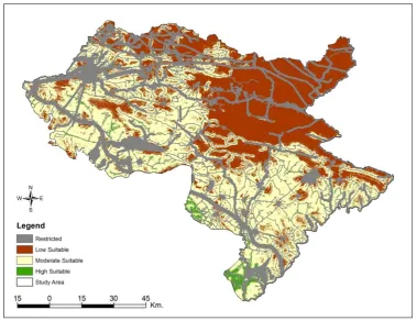
These layers combine together with scale (0), which is unsuitable for establishing this project,
while scale (1) is applicable for launching this project. In many similar studies, the same value is calculated. In the case of this paper the area of the Duhok Governorate is mostly unsuitable, especially
in the northwestern and southwestern parts of the study area, which contain large cities such as Duhok and Zakho. These urban areas also contain a dense road network. Meanwhile, the suitable
areas for solar power plants are widely distributed, particularly of the eastern and central areas of the governorate (Figure.5).
The entire Duhok province encompasses an area of 10,730.4 sq km, of which, 68.5%, or 7,349.1 sq km, is suitable for the establishment of solar farms. The remaining area, 31.5%, or 3,381.3 sq km, has been deemed unsuitable for the establishment of solar power plants (Table 3).
The findings of this study show the benefit of GIS in modeling and assisting environmental planning, as well as combining quantitative and qualitative criteria with different scales. Given the capabilities
new models, and test different methods. The AHP hierarchical analysis process in the GIS
environment has a high priority compared to the research conducted in the field of locating power plants, in addition to considering qualitative and quantitative goals. In this method, the data is then
divided into five classes (restricted, low suitability, moderately suitable and highly suitable).
Figure 5: Restricted and Available Areas Map
Type Value Area (sq.km) %
Restricted 0 3381.3 31.5
Available 1 7349.1 68.5
Entire Duhok 0 , 1 10730.4 100.0
Table 3: The area and its percentages of the restricted and available zones
The findings of this study show the ability of GIS in modeling and assisting environmental
planning as well as combining quantitative and qualitative criteria with different scales. Given the capabilities that these systems have in spatial modeling of data, compared to research, they have the
ability to generalize information, build new models, and test different methods. The Hierarchical Analysis Process in the GIS environment has a high priority compared to the research conducted in
the field of locating power plants, which is in addition to considering qualitative and quantitative goals. In this method, the data is divided into four classes (restricted, low suitable, moderately suitable, and highly suitable).
Figure-6 shows the spatial distribution of the suitability model for the solar power station, and Table 4 clarifies the allocation between the suitability classes. Low Suitable areas show an area of
especially in Amedi. The Moderately Suitable area is large and is located to the south of Akre, east of
Bardarash, in northwest of the study area. This area is 4028.8 sq.km with a ratio of 37.6%. It should be noted that, compared to the northern regions, these areas are less sloping. This paper focuses on
the Highly Suitable areas for establishing the project. They are located in the south and southwestern territories in Bardarash, Shekhan, and Semel with an area of just 132.2 sq.km (1.2%).
According to the results of this study, among the various criteria examined, economic criteria and energy security were of the utmost importance from the perspective of experts. Sub-criteria were the cost per kilowatt-hour, the security of the power plant's input source, the initial investment, the
impact on conservation and saving of end-to-end resources, which is why expanding renewable energy resources today is essential and unavoidable.
Figure 6: Solar power plants suitability model
Suitability class Pixel count Area (sq.km) %
Restricted 417,448 3,381.3 31.5
Low Suitable 68,757,246 3,187.9 29.7
Moderately suitable 497,381 4,028.8 37.5
Highly Suitable 16,320 132.2 1.2
Entire Duhok 69,688,395 10,730.2 100.0
Table 4: Suitability classes for solar power plants
Solar power is one of the world's cleanest, most renewable, available, and sustainable sources of electricity, and is less polluting in its use. A number of surface and technological issues must be
appropriate area in the south of the province for installing solar power stations. These regions include
Bardarash, Shekhan, Semel, Akre, Center, Zakho, and Amedi districts. The minimum Amedi region of 0.2 sq km with a percentage of 0.1% is shown in Table-5. Zakho, Center, and Akre have small
suitable areas of construction of a solar power plant with 1.1%, 3.6%, and 6.7% (1.4 sq. km, 4.7 sq. km, and 8.8 sq. km). Semel and Shekhan have similar results of 27.5 sq. km and 20.8% ration. Bardarash
district, with 62.1 sq. km and a 46.9% ratio, has the largest suitable area in Duhok province.
Given that large solar photovoltaic farms on the ground need space for other accessories, the total land needed for a one-MW solar photovoltaic power station would amount to approximately
16,187.4 sq. meters [35]. Thus, the area studied can produce more than 8,190 megawatts. Only Bardarash can produce about 3,850 megawatts. Shekhan and Semel can each produce 1705
megawatts, Akre, Center, Zakho, and Amedi can produce about 545.6 megawatts, 293.8 megawatts, 86.8 megawatts, and 12.4 megawatts, respectively. Concerning geographical characteristics, Highly
Suitable areas are less sloping, with more bare soil. These landscapes also get more sunshine and are far from land cover such as forests, agricultural lands, pipelines and densely populated areas, which
means that they can be the best option to help the government provide enough energy because there are few or no activities in those areas. In addition, a large portion of these Highly Suitable areas, about 95%, are located in the semi-mountainous region, whereas the small remaining percentage is located
in the mountainous territory.
Table 5: Suitable parcels and power production per district
The largest area of suitable solar power plant sites is situated among the big cities either in Iraq
or in the Kurdistan region, such as Mosul, Erbil, and Duhok (Figure-7). This significantly helps to provide clean and renewable energy to these urban centers, in addition to the study's contribution to
future work in the entire area.
District Area sq.km % Megawatt
produced
Amedi 0.2 0.1 12.4
Zakho 1.4 1.1 86.8
Center 4.74 3.6 293.8
Akre 8.8 6.7 545.6
Semel 27.5 20.8 1705
Shekhan 27.5 20.8 1705
Bardarash 62.1 46.9 3,850.2
Figure 7: Location features for high suitable solar power plant
Conclusion:
This study employed the Multi-Criteria Decision Analysis to select the optimum sites for solar power
plants in the Duhok Governorate, through the use of mathematical methods such as Boolean logic and Analytical Hierarchy Process (AHP), inside the environment of Geographical Information
Systems. The study depended upon several criteria, related to the environmental and economic aspects, such as water resources, sunshine, slope, faults, roads, transmission lines, pipelines,
settlements, and land cover/use.
There are a variety of findings in this paper, the most important of which is that 7,349.1 sq km cover
the area available for solar farm construction, which occupies 68.5% of the Duhok Governorate. This available area was divided into three grades of suitability: low-suitability, moderately suitable, and highly suitable. The most suitable area is 132.2 sq km and comprises 1.2% of the governorate; this
area can produce more than 8,190 megawatts of solar energy. 88.5% of highly suitable area is located in Bardarash (62.1 sq km), Shekhan (27.5 sq km), and Semel (27.5 sq km) in southern and
south-western area of the governorate. These suitable places for solar power plants have several significant characteristics including less sloping, baren soil, more sunshine, as well as location well away from
forests, farm fields, pipelines, and densely populated areas. This study has determined that the area best suited for solar power plant location is in the area between the big cities of Mosul, Erbil, and
Duhok, and can help provide clean and renewable energy to these urban areas. In addition, this study has helped determine other areas for future expansion in the entire region.
Supplementary Materials: The following are available online at www.mdpi.com/xxx/s1, Figure S1: title, Table S1: title, Video S1: title.
Funding: This research received no external funding.
Conflicts of Interest: The authors declare no conflict of interest.
References:
[1] M. Uyan, “Optimal site selection for solar power plants using multi-criteria evaluation : A case
study from the Ayranci region in Karaman ,” Clean Technol. Environ. Policy, 2017, doi: 10.1007/s10098-017-1405-2.
[2] A. Minelli, I. Marchesini, F. E. Taylor, P. De Rosa, L. Casagrande, and M. Cenci, “An open
source GIS tool to quantify the visual impact of wind turbines and photovoltaic panels,”
Environ. Impact Assess. Rev., vol. 49, pp. 70–78, 2014, doi: 10.1016/j.eiar.2014.07.002.
[3] M. Uyan, “GIS-based solar farms site selection using analytic hierarchy process ( AHP ) in
Karapinar region , Konya / Turkey,” Renew. Sustain. Energy Rev., vol. 28, pp. 11–17, 2013, doi:
10.1016/j.rser.2013.07.042.
[4] 2009 Aydin Yonca Nazli, “No Title,” no. July, 2009.
[5] J. Xiao et al., “Research on an optimal site selection model for desert photovoltaic power plants
based on analytic hierarchy process and geographic information system Research on an optimal site selection model for desert photovoltaic power plants based on analytic hiera,”
vol. 023132, 2013, doi: 10.1063/1.4801451.
[6] A. Asakereh, M. Omid, R. Alimardani, and F. Sarmadian, “Developing a GIS-based Fuzzy
AHP Model for Selecting Solar Energy Sites in Shodirwan Region in Iran,” vol. 68, pp. 37–48, 2014.
[7] M. A. Nazari, A. Aslani, and R. Ghasempour, “Analysis of Solar Farm Site Selection Based on
TOPSIS Approach,” vol. 9, no. 1, pp. 10–13, 2018, doi: 10.4018/IJSESD.2018010102.
[8] P. Taylor, I. Dincer, and I. Dincer, “Energy and Environmental Impacts : Present and Future Perspectives Energy and Environmental Impacts : Present and Future Perspectives,” no. December 2014, pp. 37–41, 2007, doi: 10.1080/00908319808970070.
[9] D. Ginley and N. Renewable, “Solar Energy Conversion Toward,” vol. 33, pp. 355–364, 2008.
[10] J. J. W. Watson and M. D. Hudson, “Landscape and Urban Planning Regional Scale wind farm
and solar farm suitability assessment using GIS-assisted multi-criteria evaluation,” Landsc. Urban Plan., vol. 138, pp. 20–31, 2015, doi: 10.1016/j.landurbplan.2015.02.001.
[11] G. R. F. Ibrahim, A. A. Hamid, U. M. Darwesh, and A. Rasul, “A GIS-based Boolean logic-analytical hierarchy process for solar power plant (case study: Erbil Governorate—Iraq),”
Environ. Dev. Sustain., no. 0123456789, 2020, doi: 10.1007/s10668-020-00862-3.
[12] S. S. M. Al-din, M. Iranfar, and O. S. Paper, “Renewable Energy Strategies to Overcome Power
Shortage in Kurdistan Region of Iraq,” vol. 45, no. 2, pp. 7–21, 2017, doi:
10.5937/industrija45-12770.
[13] D. H. Morad, “The Potential and Social Acceptability of Renewable Energy sources in North
Iraq : Kurdistan Region.”
[14] Husami, “Energy Crisis in Kurdistan And The Impact of Renewable Energy,” 2007.
[15] H. Z. Al Garni and A. Awasthi, Solar PV Power Plants Site Selection: A Review, vol. 1, no. February. 2018.
[16] S. Sindhu, V. Nehra, and S. Luthra, “Investigation of feasibility study of solar farms
[17] C. R. Chen, C. C. Huang, and H. J. Tsuei, “A hybrid MCDM model for improving GIS-based
solar farms site selection,” Int. J. Photoenergy, vol. 2014, 2014, doi: 10.1155/2014/925370. [18] H. Z. Al Garni and A. Awasthi, “Solar PV power plant site selection using a GIS-AHP based
approach with application in Saudi Arabia,” Appl. Energy, vol. 206, no. October, pp. 1225–
1240, 2017, doi: 10.1016/j.apenergy.2017.10.024.
[19] O. E. Demesouka, K. P. Anagnostopoulos, and E. Siskos, “Spatial multicriteria decision
support for robust land-use suitability: The case of landfill site selection in Northeastern
Greece,” Eur. J. Oper. Res., vol. 272, no. 2, pp. 574–586, 2019, doi: 10.1016/j.ejor.2018.07.005. [20] T. L. Saaty, “How to make a decision,” Int. Ser. Oper. Res. Manag. Sci., vol. 175, pp. 1–21, 2012,
doi: 10.1007/978-1-4614-3597-6_1.
[21] D. N. Tiwari, R. Loof, and G. N. Paudyal, “Environmental-economic decision-making in lowland irrigated agriculture using multi-criteria analysis techniques,” Agric. Syst., vol. 60, no. 2, pp. 99–112, 1999, doi: 10.1016/S0308-521X(99)00021-9.
[22] and N. I. Ozge Pinar Akkas, Mustafa Yasin Erten, Ertugrul Cam, “Optimal Site Selection for
a Solar Power Plant in the Central Anatolian Region of Turkey Article.” .
[23] H. Z. Al Garni and A. Awasthi, “Solar PV power plant site selection using a GIS-AHP based
approach with application in Saudi Arabia,” Appl. Energy, vol. 206, no. October, pp. 1225–
1240, 2017, doi: 10.1016/j.apenergy.2017.10.024.
[24] Y. Charabi and A. Gastli, “PV site suitability analysis using GIS-based spatial fuzzy
multi-criteria evaluation,” Renew. Energy, vol. 36, no. 9, pp. 2554–2561, 2011, doi: 10.1016/j.renene.2010.10.037.
[25] G. Van De Kaa, J. Rezaei, L. Kamp, and A. De Winter, “Photovoltaic technology selection: A
fuzzy MCDM approach,” Renew. Sustain. Energy Rev., vol. 32, pp. 662–670, 2014, doi:
10.1016/j.rser.2014.01.044.
[26] Z. Ding, M. Zhu, Z. Wu, Y. Fu, and X. Liu, “Combining AHP-entropy approach with GIS for construction waste landfill selection—A case study of Shenzhen,” Int. J. Environ. Res. Public Health, vol. 15, no. 10, 2018, doi: 10.3390/ijerph15102254.
[27] H. A. Effat, “Selection of Potential Sites for Solar Energy Farms in Ismailia Governorate, Egypt
using SRTM and Multicriteria Analysis,” Cloud Publ. Int. J. Adv. Remote Sens. GIS, vol. 2, no. 1,
pp. 205–220, 2013, [Online]. Available:
http://technical.cloud-journals.com/index.php/IJARSG/article/view/Tech-125.
[28] J. R. Janke, “Multicriteria GIS modeling of wind and solar farms in Colorado,” Renew. Energy, vol. 35, no. 10, pp. 2228–2234, 2010, doi: 10.1016/j.renene.2010.03.014.
[29] G. R. F. Ibrahim, A. Rasul, A. A. Hamid, Z. F. Ali, and A. A. Dewana, “Suitable site selection
for rainwater harvesting and storage case study using Dohuk governorate,” Water
(Switzerland), vol. 11, no. 4, 2019, doi: 10.3390/w11040864.
[30] M. Jahangiri, R. Ghaderi, A. Haghani, and O. Nematollahi, “Finding the best locations for
establishment of solar-wind power stations in Middle-East using GIS: A review,” Renew. Sustain. Energy Rev., vol. 66, no. December, pp. 38–52, 2016, doi: 10.1016/j.rser.2016.07.069. [31] H. Yousefi, H. Hafeznia, and A. Yousefi-Sahzabi, “Spatial site selection for solar power plants
using a gis-based boolean-fuzzy logic model: A case study of Markazi Province, Iran,”
Energies, vol. 11, no. 7, 2018, doi: 10.3390/en11071648.
[32] A. Hadipour, F. Vafaie, and V. Hadipour, “Land suitability evaluation for brackish water
329–343, 2014, doi: 10.1007/s10499-014-9818-y.
[33] M. Allaby, “Encyclopedia of weather and climate. Facts on File,” Facts File Inc, vol. 15, no. 4, pp. 283–290, 2007, doi: 10.1016/0305-0483(87)90016-8.
[34] D. Ignizio, “Suitability modeling and the location of utility-scale solar power plants in the
southwestern United States,” 2010.
[34] Ministry of Transport & Communication, 2019, General Directorate of Meteorology & Seismology, sunshine duration 2010 – 2019 in Duhok province
[35] Narasimhan (2014), Area Required for Solar PV Power Plants, Online available: