Bringing Back Comanche Springs
An Analysis of the History, Hydrogeology, Policy, and Economics
Report: 2020-08 December 2020Authors: Robert E. Mace, Ph.D., P.G. The Meadows Center for Water and the Environment - Texas State University
Sharlene Leurig, Texas Water Trade
Harry Seely, WestWater Research Douglas A. Wierman, P.G., Blue Creek Consulting LLC
A report for the National Fish and Wildlife Foundation, the Fort
Stockton Convention and Visitors Bureau, and the Cynthia and George
Mitchell Foundation.
Front Cover Photo: Historic postcard of the Comanche Spring pool and bath house circa 1947 (postcard from the personal collection of Robert Mace).
Back Cover Photo: Beauty pageant at Comanche Springs during the Water Carnival with the Big Chief Spring in the background (taken in 2014 by Sarah Wilson).
December 2020
Report: 2020-08Authors:
Robert E. Mace, Ph.D., P.G.
Executive Director, The Meadows Center for Water and the Environment - Texas State University
Sharlene Leurig, CEO, Texas Water Trade
Harry Seely,
Principal, WestWater Research Douglas A. Wierman, P.G. President, Blue Creek Consulting LLC
Bringing Back Comanche Springs
An Analysis of the History, Hydrogeology, Policy, and Economics
The use of brand names in this report does not indicate endorsement by the authors, the authors’ employers, or the funders.
601 University Drive, San Marcos Texas 78666
Geoscientist Seals
The contents of this report document the work of the following Licensed Texas Geoscientists:
The seal appearing on this document was authorized on June 26, 2020 by
Robert E. Mace
The seal appearing on this document was authorized on June 26, 2020 by Douglas A. Wierman, P.G.
Mr. Wierman contributed to the content on describing the geologic setting; aquifers; and pumping, desired future conditions, and modeled available groundwater. Dr. Mace contributed to these sections and all other hydrogeologic work and review.
The Leon Springs are the real thing. Messrs Beeman and Mills can show,
In Summer, Fall, Winter, and Spring, What the Leon Valley will grow. The alfalfa hay, which begins coming in May,
Is of the purest emerald green. When prices are right, it finds its way
To distant and less favored scenes. The cattle are fine, and so are the swine,
And the horses are of noble strain. The men, well, they are two of a kind,
None better from Texas to Maine.
-Anonymous
CONTENTS
Executive Summary 13 1.0 Introduction 15 2.0 Study Area 16 3.0 A Series of Springs 18 4.0 Hydrogeology 224.1 Edwards-Trinity (Plateau) Aquifer 26
4.2 Dockum Aquifer 27
4.3 Rustler Aquifer 27
4.4 Capitan Reef Complex Aquifer 27
4.5 Cross-Formational Flow 28
5.0 Use and Development 31
5.1 Pre-Irrigation 31
5.2 Spring Irrigation 34
5.3 Recreation 37
5.4 The First Wells 38
5.5 Pumps and Pumping 40
5.6 Impacts from Groundwater Production 41
5.6.1 pre-1935 42
5.6.2 1935 through 1947 42
5.6.3 post-1947 43
5.6.4 Decreasing Flows, Increasing Tensions, and a Lawsuit 45
5.6.5 Low Flow to No Flow, Declining Water Levels 49
6.0 The Return of the Springs 51
7.0 Groundwater Managemen 53
8.0 Groundwater Export? 60
9.0 Bringing Back Year-Round Springflow: How Much Pumping for How Much Flow? 63
9.1 How Much Springflow Is Needed? 63
9.2 How Much Does Pumping Need to Be Reduced? 64
9.2.1 Using the Water Budget 65
9.2.2 Using the Groundwater Model 69
10.0 Economics 73
10.1 Management Zone 1 Groundwater Permits 73
10.2 Initial Groundwater Volume Target 77
10.3.1 Leasing Full Season Permits 77
10.3.2 Leasing Partial Season Permits 78
10.3.3 Purchasing Permits 78
10.3.4 Improving Irrigation Efficiency 78
10.3.5 Switching Crops 78
10.3.6 Switching Sources 79
10.4 Preliminary Recommendations 79
10.4.1 Phased Approach 80
10.4.2 Target Wet Water 80
10.4.3 Pursue Multiple Alternatives 80
10.5 Funding Groundwater Conservation in the Comanche Springs Contributing Zone 81
10.5.1 WaterSMART 81
10.5.2 U.S. Fish and Wildlife Service Section VI 82
10.5.3 Natural Resources Conservation Service 82
10.5.4 Texas Water Development Board Agricultural Conservation Program 83
10.5.5 State Revolving Funds 83
10.5.6 State Water Implementation Fund for Texas 84
10.5.7 Annual Revenues—Pool Entry Fees 84
10.5.8 Annual Revenues—Tax Revenues from Increased Non-Local Spending 85
10.5.9 Annual Revenues—Water Sales 86
10.5.10 Municipal Bonds 87
10.5.11 Outcomes-Based Bonds 88
10.5.12 Private Equity 89
10.6 Leveraging These Sources 90
11.0 Groundwater Export 91
12.0 Recommendations 92
12.1 Hydrohistory 92
12.1.1 Research the pre-1920 flow measurements 92
12.1.2 Research Leon Springs flow data 92
12.1.3 Research the history of the Improvement District including the history of wells in its jurisdiction 93
12.2 Hydrogeology 93
12.2.1 Continuously monitor springflow at Comanche Springs 93 12.2.2 Refine estimates of the proportion of young and old water in the aquifer, including irrigation return
flows 93
12.2.3 Revisit pumping estimates 93
12.2.4 Research the hydrogeology of Comanche Creek north of Interstate-10 94 12.2.5 Increase the resolution of stress periods in the model from annual to monthly 94
12.2.6 Revise pumping, recharge, and inflow in the model 94
12.2.7 Develop a lumped parameter model 94
12.2.8 Evaluate the potential effects of a warming climate on the system 94
12.2.10 Evaluate the composite hydrograph for the Leon-Belding Irrigation Area 95
12.3 Water Market 95
12.3.1 Establish a leasing market for agricultural water 95
12.3.2 Identify most-preferred alternative aquifer in Management Zone 1 95 12.3.3 Evaluate appropriate locations for aquifer storage and recovery 96 12.3.4 Amend surface water rights on Comanche Creek to enable a broader array of uses 96 12.3.5 Form a special purpose entity to fund spring restoration 96
12.4 Policy 96
12.4.1 Remove the South Coyanosa Springs area from Management Zone 1 96
12.4.2 Consider limiting permits rather than pumping 97
12.4.3 Set desired future conditions for management zones and use the sub-regional model to evaluate the modeled available groundwater volumes instead of the regional model 97
12.4 Next Steps 97
13.0 Conclusions 98
14.0 Acknowledgments 100
15.0 References 101
LIST OF APPENDICES
Appendix A: Estimation of Seasonal Discharge (2008–2010) from the Formerly Perennial
Comanche Springs 115
Appendix B: List of Defendants and Special Defendants in the District Court Case 129
Appendix C: Flow Measurements Taken at Comanche Springs During this Study 130
Appendix D: Natural Pool Morphology 131
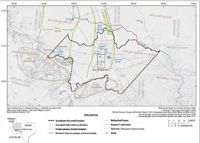
Figure 2.1 Study area 17 Figure 3.1 Study area showing springs, Leon Dam, and the Belding Fault 19
Figure 3.2 Comanche Springs 20
Figure 4.1 Hydrogeologic section of the study area 23
Figure 4.2 Major geologic structural features in the greater Pecos County area 24
Figure 4.3 Location for the cross-section 24
Figure 4.4 An approximately east-west cross-section through the study area 25 Figure 4.5 An approximately north-south cross-section through the study area 25
Figure 4.6 Major and minor aquifers in the study area 26
Figure 4.7 Groundwater levels in Edwards-Trinity, Rustler, and Capitan Reef aquifers 29 Figure 5.1 Discoloration of alluvium in Comanche Creek downstream from Comanche (and other) Springs 32 Figure 5.2 Detail of the artificial ciénega built by Texas Parks and Wildlife Department at San Solomon Springs 32 Figure 5.3 A survey from 1875 showing the original irrigation ditches 35 Figure 5.4 Primary irrigation ditches in the Fort Stockton area circa 1902 36 Figure 5.5 Evolution of the swimming hole at Big Chief and Government springs 37 Figure 5.6 Six wells drilled between 1916 and 1917 around Leon Springs by the Leon Springs Irrigation Company 39
Figure 5.7 Photograph of the first pumping well drilled in the Leon-Belding area by the Davenport Irrigation Land Associates 40
Figure 5.8 Springflow at Comanche Springs from 1941 to 1965 43
Figure 5.9 Spring flow at San Pedro Spring 44
Figure 5.10 Composite hydrograph from wells in the Leon-Belding Irrigation Area 44 Figure 7.1 Groundwater management zones in the Middle Pecos Groundwater Conservation District 55
Figure 7.2 Management Zone 1 55
Figure 7.3 Modeled available groundwater, permitted production, and recent production for the Edwards-Trinity Aquifer in Groundwater Management Area 7 58
Figure 7.4 Modeled available groundwater, permitted production, and recent production and for the Rustler Aquifer 58
Figure 7.5 Modeled available groundwater, permitted production, and recent production and for the Capitan Reef Aquifer 59 Figure 9.1 Estimates of pumping in the Leon-Belding Irrigation Area and Management Zone 1 68 Figure 9.2 Historical pumping in the Harden and others (2011) model for Management Zone 1 and seven scenarios of projected pumping 71
Figure 9.3 Simulated flow at Comanche Springs for the historical pumping in the Harden and others (2011) model for Management Zone 1 and for seven scenarios of projected pumping 72 Figure 10.1 Modeled contributions of groundwater storage to springflow at Comanche Springs 74
LIST OF FIGURES
Table 7.1 Average drawdowns for the desired future conditions in Management Zone 1 57
Table 7.2
Desired future conditions, modeled available groundwater volumes, and recent production for the relevant aquifers in the Groundwater Management Area 7 Portion of the Middle Pecos
Groundwater Conservation District 57
Table 9.1 Estimates of pumping in the Leon-Belding Irrigation Area and Management Zone 1 66 Table 10.1 Summary of the largest permit holders in the Edwards-Trinity Aquifer 76 Table 10.2 Estimated volume and annual cost for each alternative to reduce groundwater pumping. 80 Table 10.3 Summary of funding options for the various conservation options 81 Table 10.4 Estimated pledgeable revenues from non-local visitation to Comanche Springs. 88
LIST OF TABLES
Figure 10.2 Permitted volume and annual groundwater use in Management Zone 1 from 2008 through 2016 74 Figure 10.3 Irrigated land and general crop categories produced during 2016 75 Figure 10.4 Summary of the crops grown within the Management Zone 1 during 2016 75 Figure 10.5 The natural pool at San Solomon Springs near Balmorhea, Texas 85
EXECUTIVE SUMMARY
Comanche Springs, once the sixth largest spring system in Texas with 66 cubic feet per minute of flow, have a long and storied history, from mammoths sipping its brackish flow to hosting conquistadors and frontier forts to irrigating thousands of acres to being the focus of a key court decision. Unfortunately, due to pumping seven miles to the west, the springs started to fail in 1947 and stopped flowing in 1961 for 25 years. Along with the loss of Fort Stockton’s natural swimming hole and the livelihoods of more than 100 families downstream was an ecosystem that supported several species now recognized as endangered, including the Comanche Springs pupfish. In 1986, the springs sprang back for a couple winters, disappeared, and then returned off and on in ensuing decades. Consistent winter flow over the past decade had posed the question: What would it take to bring springflows back over the entire year? Therefore, the purpose of this study was to conduct an historical, hydrogeologic, policy, and economic review to inform residents, regulators, and policymakers on what it would take for Fort Stockton to call itself Spring City once again.
By evaluating historic hydrogeologic reports and newspaper accounts of the development of spring-fed irrigation at Leon and Comanche springs and pump-spring-fed irrigation in the Leon-Belding Irrigation Area, we compiled the most comprehensive, quantified timeline of known hydrologic events for the flow system. Most importantly, we rediscovered the flow-enhancing wells drilled at Leon Springs between 1915 and 1916 and reconstructed, through newspaper reports and analysis, how much these wells enhanced flow at the springs (and decreased flow at Comanche Springs). This rediscovery has implications for the system’s water budget, estimates of pumping and recharge in the numerical groundwater flow models, and the long-term sustainable management of the aquifer. A systematic analysis of historical estimates of pumping and springflows reveals that the groundwater model currently used by the groundwater conservation district probably overestimates pumping by as much as 50 percent when the springs first went dry. We also found that a simple water budget approach can be used to represent flows volumes in the system and, in turn, estimate pumping when there is flow at Comanche Springs despite not including spatial and temporal variations in pumping and its effects. The Middle Pecos Groundwater Conservation District describes its mission as helping to “…maintain a sustainable, adequate, reliable, cost effective and high-quality source of groundwater to promote the vitality, economy and environment of the District.” The district’s rules include aquifer-based production limits based on achieving the desired future conditions of aquifers in the district, including within management zones, one of which encompasses the flow system for Comanche Springs. The district’s current management approach, while seeking to achieve sustainability, is not amenable to creating a water market to maintain springflows because, overall, while pumping is limited, permits are not. There are several options the district could employ to limit permits in addition to pumping, including a correlative rights approach for production permits (which do not include historic and existing uses) in Management Zone 1.
Based on results of a topographic survey, state code on turnover in pools, and nearby spring analogues of flow for pupfish and other species, we estimated that daily flow through a restored natural pool at Comanche Springs needs to be at least 10 cubic feet per second for health and human safety and species requirements. Because of seasonal variations due to irrigation pumping, we determined that average annual springflow needs to be 20 cubic feet per second to achieve this minimum. Using a variety of methods, we identified that pumping needs to be between 26,000 to 35,000 acre-feet per year (with the lower number more likely) to achieve at least 10 cubic feet per second of daily flow at Comanche Springs.
We evaluated six different alternatives to reduce groundwater pumping in the Edwards-Trinity Aquifer if permits could be limited to create a market. Leasing full season permits could reduce pumping by 8,400 acre-feet per year at a cost of $75 to $150 per acre-foot. Leasing partial season permits could reduce pumping by 1,800 acre-feet per year at a cost of $75 to $150 per acre-foot. Improving irrigation
efficiency could reduce pumping by 2,000 acre-feet per year at a cost of $50 per acre-foot. Switching crops could reduce pumping by 2,250 acre-feet per year at a cost of $1,067 per acre-foot. Switching sources could reduce pumping by 9,235 acre-feet per year at a capital cost of $735 per acre-foot and an annual operating cost of $144 per acre-foot. Purchasing permits could reduce pumping by more than 9,200 acre-feet per year (we did not identify a cost for this alternative due to on-going price negotiations).
We also identified funding sources to implement the alternatives, including WaterSMART, U.S. Fish and Wildlife Service Section VI, Natural Resources Conservation Service, Texas Water Development Board Agricultural Conservation Program, state revolving funds, State Water Implementation Fund for Texas, pool entry fees, tax revenues from increased non-local spending, water sales, municipal bonds, outcomes-based bonds, and private equity. The restoration of Comanche Springs could—and likely would—be enabled through a blending of these various financial resources. What makes the restoration of Comanche Springs viable is the multiple economic and ecological benefits that restored surface flows would achieve. Project sponsors would be right to think of restoring Comanche Springs primarily as an economic development project. Total pledgeable new revenues from non-local visitation to a restored Comanche Springs could amount to $1.9 million a year.
We believe the next steps involve a multi-pronged approach, some of which is already in process, such as establishing a pilot market, incentivizing on-farm efficiency improvements, and improving the groundwater model. Given the importance of pumping estimates, not only to estimating the amount of pumping needed to maintain year-round springflow but also to managing groundwater resources in Management Zone 1, we strongly recommend a thorough analysis of pumping in the Leon-Belding Irrigation Area, especially since the current model is calibrated with overestimated pumping. The groundwater district should also measure springflow in real-time to not only have flow for Comanche Springs but also serve to check pumping estimates. Finally, the groundwater district should explore what it may be willing to do to limit permitted volume, and there should be discussions on which pumping reduction strategies users would be willing to do.
While there have been a number of hydrogeologic studies conducted over the past 70 years, this is the first to fully assemble the history of the flow system and evaluate the policy and economics of bringing year-round flow back to Comanche Springs. While challenges remain large, we have developed the first roadmap to restoring the springs. Opportunity waits.
1.0 INTRODUCTION
Once the sixth largest spring in Texas (Sharp 2001), Comanche Springs produced its last trickles on March 19, 1961, before going dry for more than 25 years. These historic springs, having previously flowed for thousands of years, were a watering hole for mammoths, camels, and sloths during the last ice age and sustained a vibrant desert ecosystem through the 1950s. Humans have used the springs for at least 20,000 years, first serving as water stops for thirsty travelers, then hosting the namesake garrison for Fort Stockton, and then providing irrigation water for more than 100 downspring families, turning a brown valley green.
The springs have not flowed reliably since the 1950s when pump-fed irrigated agriculture expanded in the Leon-Belding area about eight miles west. Significant groundwater production in the Edwards-Trinity Aquifer in this area caused spring flows to decline precipitously in the 1950s and led to a seminal court case, Pecos County Water Control and Improvement District No. 1 v. Williams and others, which determined that, under the Rule of Capture, no liability could be assessed against groundwater irrigators, even if they caused springs to stop flowing and affected the surface-water rights of downspring irrigators. Soon after the court’s decision, farms along Comanche Creek were entirely extirpated, as were the populations of desert fish that once thrived in the springs.
In October 1986, Comanche Springs gurgled back to life, igniting memories of days gone by, inspiring a study on the hydrogeology of the area, and sparking an attempt to form a groundwater conservation district, later created and confirmed in 1999 and 2002, respectively. Since at least 2011, springflows have returned every winter season, drawing visitors and bringing a twinkle to the dwindling number of local eyes who remember when the springs flowed freely into its natural basin.
The consistent return of seasonal flow to Comanche Springs over the past decade begs the question: What would it take to bring flows back over the entire year? This is a question that requires a study of the history of the springs and pumping in the area, a review of what is known about the science of the aquifer, an assessment of the economics, and an appraisal of local groundwater policy. Although there have been a number of scientific studies of the aquifers in the area over the past 100 years, none have put the science in the context of the history of what happened, the policy that exists, or the economics of returning year-round flow to the springs. The purpose of this study was to conduct an historical, hydrogeologic, policy, and economic review to inform residents, regulators, and policymakers on what it would take for Fort Stockton to call itself Spring City once again. Although this project is focused on a small, but storied, part of West Texas, the general intersection of history, science, policy, and economics is relevant to the rest of Texas—or anywhere, really—where springs have been impacted by pumping and where discussions are focused on the sustainable development of groundwater.
Accumulation of flow from Comanche Springs at an ephemeral wetland just upstream from the diversion dam. The original gates, now inoperable, are to the left (taken on March 10, 2018 by Robert Mace).
2.0 STUDY AREA
The study area is in Pecos County where the High Plains lap up against the Basin and Range Province in West Texas (Wermund 1996). The High Plains form a nearly flat plateau which, in the study area, is part of the Edwards Plateau, while the Basin and Range Province is represented by mountain ranges alternating with basins (Wermund 1996). More locally, the study area extends from the east side of Fort Stockton where Comanche Springs issue from, west seven miles along a presumed flow path toward the now-defunct Leon Springs, south of Interstate 10 through the Leon-Belding Irrigation Area and then south to the Glass Mountains (Figure 2.1). Average annual temperature is about 60° Fahrenheit, average annual rainfall is about 15 inches, and average annual gross lake evaporation is about 75 inches (TWDB 2012). Land-surface elevation slopes from about 5,000 feet above sea level in the Glass Mountains to 2,900 to 3,000 feet along Interstate-10.
Fort Stockton is the county seat for Pecos County and is by far the largest community in the county with an estimated 8,318 residents as of July 1, 2018 (U.S. Census Bureau 2020). The community of Belding was platted in 1913 along the railroad but, due to the cost of pumping water, was never realized; its hotel was later moved to Leon Lake (Justice 2010a).
Figure 2.1: General study area showing the location of the Belding Area, Comanche Springs, and the Glass Mountains as well as the location of Balmorhea (base map from Google 2020).
3.0 A SERIES OF SPRINGS
There are several historical springs and at least one still-flowing spring in the area. Comanche Springs on the east side of Fort Stockton was the largest (Figure 3.1) with a flow of 40 to 45 cubic feet per second between 1919 and 1949 (Atkins 1927; Armstrong and McMillion 1961) and two measurements—one in summer 1899 and one on July 26, 1904—of 66 and 64 cubic feet per second, respectively (Meinzer 1927; Taylor 1902 reports a value of 70 cubic feet per second for 1899). Total dissolved solids in Comanche Springs was about 1,330 parts per million between 1932 and 1958 (USGS 2020a) with a reported constant water temperature of 72° F (temperatures measured for flow reappearances in 1987 and 1991 were 64° F and 70° F, respectively [USGS 2020a]).
As the name indicates, there are several major, minor, and unnamed springs that make up the Comanche Springs, including Main or Big Chief Spring and Government Spring, both at the modern-day pool (Figure 3.2). These two springs are at the lowest elevation of the spring complex. Heading up-stream, there’s Koehler’s Spring, Blue Hole, Church Spring, Jail Spring, and Head Water Spring along with various unnamed seeps and springs along the way (Collett 2011). Baker and Bowman (1917) described the springs as either fissure springs rising along fault lines or springs in solution channels. Before the springs failed, Comanche Creek reportedly flowed four miles downstream before sinking into the ground (Adkins 1927, Williams 1982 p132).
There were also several springs downstream from Comanche Springs (Figure 3.1), the most prominent being San Pedro Spring, which flowed 3.6 to 4.9 cubic feet per second before 1951 (Armstrong and McMillion 1961; Brune 1975). To the southeast of San Pedro Spring, on the opposite bank of Comanche Creek, was Cold Spring (Figure 3.1) which flowed 2.55 cubic feet per second on October 16, 1942 (Parker and others 1944, USGS 2020a). Cold Spring was known for its “ice cold” water (Fort Stockton Pioneer 1908b) and provided enough flow for fishing (Fort Stockton Pioneer 1915e). Further downstream near the intersection of 1053 and Buena Vista Road there was San Simon Spring (80 gallons per minute [0.21 cubic feet per second] on May 11, 1943, with a temperature of 64° F [Dante 1947]), Adobe Springs (170 gallons per minute [0.45 cubic feet per second] on October 28, 1932 [Dante 1947]), Johnson Spring (140 gallons per minute [0.37 cubic feet per second] on May 12, 1943, with a temperature of 65° F [Dante 1947]), and Travertine Spring (Dante 1947). Veni (1991) speculated that the primary discharge point in the Comanche Creek area was 33 to 43 feet lower that Big Chief and Government springs and moved uphill as the creek valley was capped with alluvial fill during the Pleistocene.
Figure 3.1: Our study area is focused on the Leon-Belding Irrigation Area, Leon Springs, and Comanche Springs, but we also discuss the other springs shown (base map from Google 2020).
Figure 3.2: Comanche Springs (based on maps from Brune 1981, Small and Ozuna 1993, and Collett 2011; base map from Google 2020). Small and Ozuna (1993) show a Main Spring beneath the pool in addition to Chief and Government whereas Collett (2011) shows Big Chief and Main being the same spring. Solid circles represent spring locations that still show evidence today of their existence. Open circles are approximate spring locations with no evidence today of their existence.
In the Leon-Belding Irrigation Area, there was Leon Springs (Figure 3.1), referred to historically as Leon Holes since the springs issued from three natural holes that averaged 30-feet in diameter and 20-feet deep (Williams 1923, Williams 1982). Flows at the springs were about 10,000,000 gallons per day (about 15.5 cubic feet per second; Fort Stockton Pioneer 1911a) with total dissolved solids of 1,416 parts per million (Fort Stockton Pioneer 1911b). Flow at Leon Springs (which included by this time flows from five nearby flowing wells) ranged from 23 cubic feet per second for water year 1920 to 14 cubic feet per second for water year 1946 before drying up for good in 1958 (Brune 1975). Armstrong and McMillion (1961) noted that Leon Springs and a few nearby wells produced about 9,000 acre-feet per year (12.4 cubic feet per second) prior to 1946.
About 10 miles to the northeast, farther down Leon Creek, is Diamond Y Spring, which flowed at 0.43 cubic feet per second on May 10, 1943 (USGS 2020a); had no reported flow in 1971 (Brune 1975); was flowing in 1987 (Veni 1991); was flowing in 1990 (Boghici 1997); flowed 0.43 cubic feet per second on January 1, 1992; flowed between 0.0 and 0.25 cubic feet per second between October 27, 2010, and December 12, 2014 (USGS 2020a); and continues to flow today. Veni (1991) reported much higher flows at between 1.4 and 2.1 cubic feet per second at Diamond Y Spring proper and 3.2 to 5 cubic feet per second for the entire spring complex. Total dissolved solids measured on August 8, 2010, was 5,000 parts per million with a temperature of 69° F (USGS 2020a). Other springs are noted in the area by Armstrong and McMillion (1961) and Small and Ozuna (1993).
Land-surface elevations, from highest to lowest, are ~3,000 feet above sea level at Leon Springs; ~2,940 feet at Head Spring and ~2,930 feet at Big Chief Spring, both part of Comanche Springs; ~2,830 at Cold Springs; ~2,810 feet at San Pedro Spring; 2,790 feet at Diamond Y Spring; and ~2,670 feet at San Simon Spring (based on data from USGS 2020b).1
Out of the study area in the Balmorhea area (Figure 2.1), about 50 miles to the west of Fort Stockton, are San Solomon, Phantom Lake, Saragosa, Giffin, and East and West Sandia springs.
1 Elevations for several of the springs listed are approximate because the exact location of the springs are approximate.
4.0 HYDROGEOLOGY
The study area includes geology and aquifers of Permian (Capitan Reef and Rustler aquifers), Triassic (Dockum Aquifer) and Cretaceous (Edwards-Trinity [Plateau] Aquifer) ages as well as Cenozoic-aged sediments (Pecos Valley Aquifer) (Bumgarner and others 2012; Figure 4.1). Dissolution of Permian salts created the Belding-Coyanosa Trough that cuts north-south through the study area (Figure 4.2). The faulting that resulted from this dissolution is a key geologic component for the existence of the Leon-Belding Irrigation Area, Leon Springs, Comanche Springs, and other springs in the area. An approximately east-west cross-section through the study area (Figure 4.3) shows that the Edwards rocks in the Leon-Belding Irrigation Area are down-dropped about 500 feet, creating a local basin of karstified limestone in the area (Figures 4.4 and 4.5).
Figure 4.1: Hydrogeologic section of the study area (modified from Clark and others 2013; modifications include the highlighting of the aquifers and dissolving the line for the Edwards-Trinity Aquifer between the Edwards and Trinity layers, an error in the original).
Figure 4.2: Major geologic structural features in the greater Pecos County area (from Clark and others 2013).
Figure 4.4: An approximately east-west section through the study area (location of the cross-section shown in Figure 4.3; from Bumgarner and others [2012]).
Figure 4.5: An approximately north-south section through the study area (location of the cross-section shown in Figure 4.3; from Bumgarner and others [2012]).
Figure 4.6: Major and minor aquifers in the study area (from Clark and others 2013).
4.1 E DWA RD S -T RINI T Y ( PL AT E AU ) AQ UIF E R
The Edwards-Trinity (Plateau) Aquifer (referred to hereafter as the Edwards-Trinity Aquifer) is a major aquifer system of Texas (George and others 2011), underlies the entire study area, and is the primary source of water in the area as well as the source of much of the water for irrigation in the Leon-Belding Irrigation Area and spring flows to Comanche Springs (Figure 4.6). The Edwards part of the aquifer consists of limestone, marl, and clay (Clark and others 2013) and yields small to large amounts of water (Rees and Buckner 1980) while the Trinity part of the aquifer consists of sand, limestone, and shale (Clark and others 2014) and yields small to large amounts of water (Rees and Buckner 1980; small is less than 50 gallons per minute, moderate is 50 to 500 gallons per minute, and large is more than 500 gallons per minute). Although groundwater is available in both the Edwards and Trinity parts of the aquifer, the Edwards part is far more productive. Limestones of the Edwards—with caverns reported to be as large as eight feet—can produce as much as 3,000 gallons per minute (Audsley 1956, Armstrong and McMillion 1961).
Armstrong and McMillion (1961) note that the productive parts of the Edwards-Trinity Aquifer in the Leon-Belding Irrigation Area are mostly limited to a five-mile-wide area between the locally-known Belding Fault (which lies approximately along Brangus Road; Figure 3.1) to two miles south of this fault with a one-mile-wide productive area south of that. The current distribution of agriculture suggests that there is a productive zone north of the Belding Fault probably along a flowpath to Leon Springs.
Groundwater is under water-table conditions in the Edwards-Trinity Aquifer in the study area although artesian conditions have been observed in the Leon-Belding Irrigation Area north of the Belding Fault where the Edwards rocks are overlain with clays (Armstrong and McMillion 1961). Regional groundwater flow directions are generally to the north and northeast towards the Pecos River (Bumgarner and others 2012). Bumgarner and others (2012) interpreted a groundwater divide between the northern Leon-Belding Irrigation Area and Comanche Springs near Twomile Hill during winter water levels, a divide that then cuts across the Leon-Belding Irrigation Area. Given the faulting and karstification in the Leon-Belding Irrigation Area and through a flowpath to Comanche Springs, anisotropy complicates using the potentiometric surface to identify local flowpaths.
Hydraulic gradients in the Leon-Belding Irrigation Area show a lower gradient south of the Belding Fault than north of it (Bumgarner and others 2012 p 44), suggesting greater aquifer productivity to the south and lower aquifer productivity to the north, something that is observed in the field. The flowpath to Comanche Springs may begin on the eastern end of the Belding Fault in the irrigation area. Cavers have explored the conduit system at Comanche Springs back as far as Rooney Street (Veni 1991).
4.2 DO C K UM AQ UIF E R
The Dockum Aquifer is a minor aquifer of Texas (George and others 2011) and extends into the northwestern part of the study area (Figure 4.6), although the rocks that make up the Dockum Aquifer extend beneath the study area with poorer water quality. The Dockum Aquifer consists of shale, sand, sandstone, and conglomerate (Clark and others 2014) and can yield small to moderate amounts of water (Rees and Buckner 1980). There is little information on the Dockum Aquifer in the study area. Because the Dockum Aquifer consists mostly of shale in the study area and yields much less water than the overlying Edwards-Trinity Aquifer, it is considered a confining layer (Clark and others 2014), a hydrologic feature that generally impedes groundwater flow.
4.3 RU S T L E R AQ UIF E R
The Rustler Aquifer is a minor aquifer of Texas (George and others 2011) and exists under most of the study area (Figure 4.6). The Rustler Aquifer consists of dolomite, anhydrite, and some limestone with a basal unit of sand, conglomerate, and some shale (Clark and others 2014) and yields small to moderate amounts of slightly to moderately saline water (Rees and Buckner 1980). The dolomite and limestone have vugular porosity and are reported to be cavernous in places (Small and Ozuna 1987). Wells completed in the Rustler Aquifer have been developed to supplement the Edwards-Trinity wells in the Belding area (Rees and Buckner 1980). Groundwater in the Rustler appears to move from southwest to northeast in the study area, although data is sparse (George and others 2011; Ewing and others 2012). The aquifer is under artesian conditions in the Leon-Belding Irrigation Area based on data collected by the Middle Pecos Groundwater Conservation District.
4.4 C A P I TA N RE E F C OMPL E X AQ UIF E R
The Capitan Reef Complex Aquifer (hereafter referred to as the Capitan Reef Aquifer) is a minor aquifer of Texas (George and others 2011) that extends through the heart of the study area (Figure 4.6). This aquifer directly underlies the Rustler Aquifer west of Fort Stockton; consists of massive, poorly bedded limestone, dolomite, and reef talus; and has a maximum thickness of about 1,650 feet (Small and Ozuna 1993). The reef occurs in a 6- to 10-mile-wide, south-southeast trending belt, extending from New Mexico through western Winkler, central Ward, and western Pecos counties. Depth to the top of the aquifer in the study area ranges from 2,400 to 3,600 feet (Ashworth 1990).
There is little data available in the Leon-Belding Irrigation Area on hydrologic conditions in the Capitan Reef Aquifer. Because of its depth and moderately saline water, the Capitan Reef Aquifer has not been an important aquifer in Pecos County; however, with limited water supplies in West Texas, there is growing interest in tapping it resources. The aquifer is under artesian conditions in the study area based on data collected by the Middle Pecos Groundwater Conservation District. The district has one monitoring well completed in the Capitan Reef Aquifer with a relatively short period of record.
4.5 C RO S S -F ORM AT ION A L F L OW
Cross-formational flow is when water moves from one hydrogeologic unit to another. In the present case, we are focused on how water may or may not flow from one aquifer to another. In general, for cross-formational flow to occur between adjacent or stacked aquifers, two conditions must exist. First, there must be a hydraulic head difference between the two adjacent formations (in other words, one aquifer has a higher water pressure than an adjacent aquifer creating the potential for water to flow from the higher-pressured aquifer to the lower-pressured aquifer). Second, there must be a pathway to allow water to move from one aquifer to another. Potential pathways may include through a confining layer, fractures, faults, or karst features.
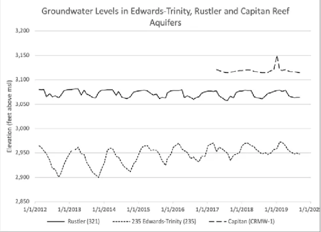
Armstrong and McMillion (1961) speculated that water may flow from the Rustler Aquifer into the Edward-Trinity Aquifer in this part of Pecos County. Bumgarner and others (2012) analyzed water-level data from two wells in the Edwards-Trinity Aquifer and two wells in the Rustler Aquifer to determine vertical gradients between the two aquifers in the Leon-Belding Irrigation Area. They determined that vertical gradients were upward from the Rustler Aquifer towards the Edwards-Trinity Aquifer, with hydraulic head differences ranging from 83 to 121 feet (hydraulic head is a measure of water “pressure” in an aquifer). This pressure difference indicates the potential for water to move from the Rustler Aquifer to the Edward-Trinity Aquifer.
We acquired water-level data from the Middle Pecos Groundwater Conservation District in three wells in the Leon-Belding Irrigation Area, one in each for the Capitan Reef Aquifer, the Rustler Aquifer, and the Edwards-Trinity Aquifer, and plotted them together (Figure 4.7). These water-level data confirm Bumgarner and others’ (2012) conclusions that there are upward vertical gradients from the Capitan Reef Complex Aquifer to the Rustler Aquifer and, in turn, from the Rustler Aquifer to the Edwards-Trinity Aquifer. The average hydraulic head difference between the Edward-Trinity and Rustler aquifers is 125 feet with a hydraulic head difference between the Capitan Reef Complex and Rustler aquifers of 47 feet.
Potential pathways in the Leon Belding Irrigation Area include general upward groundwater flow across the geologic layers but also the faulting associated with Belding-Coyanosa Trough that cuts though the study area. Hiss 1976 (as referenced in Small and Ozuna 1993) suggested that a connection between the Capitan Reef Aquifer and the Edwards-Trinity Aquifer probably occurs where joints, fractures, and faults are well developed.
Similarly, Ashworth (1990), Boghici (1997), and Bumgarner and others (2012) suggested that upwelling is likely the result of groundwater flow from underlying aquifers along fault zones. Small and Ozuna (1993) hypothesized that flow may occur in areas where a Triassic shale unit that separates the Trinity Group of the Edwards-Trinity Aquifer from underlying units is absent. While hydraulic head differences and faulting suggest cross-formational flow is possible, it does not prove that cross-formational flow is occurring. Comparing water chemistry between the aquifers is a way to confirm aquifer-to-aquifer connections. The first clue to this is that water in the Edwards-Trinity Aquifer in the Leon-Belding Irrigation Area and from Comanche Springs is brackish,
generally around 1,500 milligrams per liter (Dennis and Lang 1941, Boghici 1997). In general, water quality in the broader Edwards-Trinity Aquifer is fresh, typically less than 1,000 milligrams per liter (Anaya 2004). Given the proximity of the Leon Belding Irrigation Area to the recharge zone for the Edwards-Trinity Aquifer (20 miles to the south), it is unlikely that water in the Edwards-Trinity Aquifer would be as saline as it is without cross-formational flow from more saline aquifers beneath it. Total dissolved solids in the Rustler Aquifer in the Leon-Belding Irrigation Area is also about 1,500 milligrams per liter (Boghici 1997) while two wells in the Capitan Reef Complex Aquifer in the Leon Belding Irrigation Area range from 1,100 to 1,900 milligrams per liter.
Bumgarner and others (2012) use geochemistry to conclude that groundwater in the Monument Draw trough (which includes the Leon- Belding Irrigation Area) originated as “recharge in the Glass Mountains, agricultural return flows, or upwelling groundwater.” They noted that groundwater in the Edwards-Trinity, Rustler, and Capitan Reef aquifers was probably recharged during the wetter and cooler climates of the Pleistecene, more than 10,000 years ago. Bumgarner and others (2012) also used geochemistry to confirm the connection between Comanche Springs and groundwater in the Leon-Belding Irrigation Area.
Geochemical modeling by Clark and others (2014) suggests that water in the Edwards-Trinity Aquifer in the Leon Belding Area is a mixture of recharge from the Barilla and Davis mountains and cross-formational flow from the Rustler Aquifer. Their geochemical modeling also suggests that groundwater in the Edwards-Trinity Aquifer just north of Belding is about 0 to 48.8 percent from the Rustler Aquifer and in the Leon Springs area is about 87.1 to 100 percent from the Rustler Aquifer.
Oxygen and hydrogen isotopes in groundwater can be used to assess when groundwater was recharged (see, for example, Uliana and others 2007). These isotopes suggest that groundwater from the
Edwards-Figure 4.7: Groundwater levels in Edwards-Trinity, Rustler, and Capitan Reef aquifers (data from the Middle Pecos Groundwater Conservation District; msl = mean sea level).
Trinity Aquifer in the study area is a mixture of recent, local recharge and older water that recharged under a different climate (Bumgarner and others 2012). Oxygen and hydrogen isotopes measured in the Rustler Aquifer in the Leon-Belding Irrigation Area, in the Capitan Reef Aquifer, and in Comanche Springs suggest that most of the water is older recharge (consistent with the findings of Uliana and others 2007); however, the detection of atrazine and elevated nutrients in the Leon-Belding Irrigation Area and Comanche Springs suggests a local source of recharge as well (Bumgarner and others 2012). Bumgarner and others (2012) noted that although there is a local component of recharge, it only occurs at the mountain front and in areas receiving irrigation return flows. Relatively steady springflow from year-to-year before groundwater pumping increased in the late 1940s also suggests a broader and older source of water to the springs. Harden and others (2011) pointed to soil studies to conclude that there was no irrigation return flows in the Leon-Belding Irrigation Area; however, the subsequent detection of pesticides and elevated nutrients in the area by Bumgarner and others (2012) suggest otherwise.
5.0 USE AND DEVELOPMENT
The use and development of water at the springs has four broad phases: (1) pre-irrigation, (2) spring irrigation, (3) groundwater irrigation, and (4) groundwater export. We reviewed historical documents, newspaper accounts, and existing reports to develop a timeline of what is known about fauna and flora and the timing and use of the springs for irrigation and other purposes. This helps to put the spring systems into context of the larger goal of assessing what it would take to bring Comanche Springs back and to better understand water budgets for the area.
5.1 PRE -IRRIG AT ION
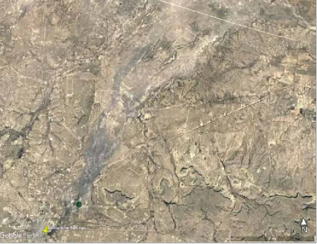
Before human intervention, Comanche Springs issued from a series of locations along Comanche Creek, some from a small limestone bluff and others from alluvium (Figure 3.2). Springflows moved down Comanche Creek in a shallow valley and then disappeared into the ground a few miles downstream (Adkins 1927, although this observation was made after irrigation works had been installed, which would have affected downstream flows). Satellite imagery shows an alluvial fan spreading out just beyond the north side of present-day Interstate-10 with a dark-grey discoloration of the landscape (Figure 5.1). Some local residents attribute the discoloration to incineration activities at the landfill located along the creek just north of the interstate; however, the discoloration is seen upstream from the landfill and similar discoloration is seen downstream of Leon Springs, which used to be part of the same flow system seven miles to the west. The discoloration suggests a geochemical process of spring water interacting with the alluvium. If the discoloration is a geochemical process associated with spring chemistry, springs in the area appear to have flowed at least 20 miles downstream.
Springflows would have supported a large wetland system downstream from the springs.2 A small
wetland system exists today at Diamond Y Springs (Van Auken and others 2007), and the Texas Parks and Wildlife Department built an engineered wetland system at San Solomon Springs to approximate the natural system before it was pooled and channelized in the 1930s for recreation and irrigation (Chapman and Bolen 2018; Figure 5.2). Excavations at San Pedro Springs revealed animals from the Pleistocene, during the last ice age some 30,000 to 10,000 years ago, roamed the area, including mammoths, camels, and sloths (Warnock 1972, Collett 2011).
2 A map of the irrigation system in place by 1875 (Figure 5.3) shows a broad area in Comanche Creek referred to as “Laguna de Comanche” stretching from present-day Interstate-10 to at least Sevenmile Mesa.
Water well with pump and engine in the Leon-Belding Irrigation Area with a pecan farm in the background (taken on January 12, 2020 by Robert Mace)
Figure 5.1: Discoloration of alluvium in Comanche Creek downstream from Comanche (and other) Springs (image from Google 2020).
Figure 5.2: Detail of the artificial ciénega built by Texas Parks and Wildlife Department at San Solomon Springs (photo by Robert Mace, September 14, 2015).
Captain William Henry Chase Whiting of the U.S. Army noted in 1849 that flow from Comanche Springs held abundant fish and turtles (Justice 2010b) while in 1853 Julius Froebel described catching catfish in Comanche Creek (Ely 2016). In 1853, Julius Froebel noted rushes, reeds, and bogs as well as turtles at Leon Springs (Ely 2016).
Baird and Gerard (1853) provide the earliest scientific description of species in the Fort Stockton area when they described three new species of fish—the Comanche Springs pupfish and the Leon Springs pupfish, collected from their namesake springs, and the Pecos gambusia, from both springs—during the United States and Mexican Boundary Survey (Emory 1857). Hubbs (1978) noted that Mexican tetra had been collected at Leon Springs in 1938.
Van Auken (2007) described plant species in the marshes of Diamond Y Springs including the federally threatened Pecos sunflower, the Leoncita false foxgrove, the federally listed Pecos gambusia, and three rare snail species (Tryonia circumstriata=stocktonensis, Pseudotryonia=Tryonia adamantia, and Assiminea pecos, the latter federally endangered [Ladd 2010]). Echelle and Miller (1974) rediscovered the Leon Springs pupfish at Diamond Y Springs after it was thought extinct (Hubbs 1957, Miller 1961). Leon Springs had been inundated by a small reservoir in 1918 (Hubbs 1978), dosed with the piscicide rotenone in 1947 to kill all the fish in the system to get rid of the carp, (Fort Stockton Pioneer 1947a, Knapp 1953 as referenced by Hubbs 1978), and, ultimately, ceased to flow.
Hubbs (1978) described a variety of species at Diamond Y Springs, some of which may have also lived in Leon and Comanche springs. The Comanche Springs pupfish also lives in Phantom Lake Spring (now supported by pumping from the spring’s cave system), San Solomon Spring, Giffin Spring, and East and West Sandia Springs (Winemiller 1997).
San Pedro Springs has evidence of human activity going back nearly 20,000 years (Warnock 1972). Apaches were already invading Jumano territory before the Spaniards arrived in the 1550s (Hickerson 2019), but the acquisition of horses introduced by the Spanish assisted them in driving out or incorporating the Jumanos by the end of the 1600s (Hickerson 2019).
Cabeza de Baca possibly visited the Comanche Springs in 1536 (Brune 1975). Juan Domínguez de Mendoza described six large springs forming Comanche Creek, named them San Juan del Rio, and described buffalo and nut trees at the springs in 1684 (Brune 1975, Collett 2011). Mendoza’s journal states that “It is a beautiful plain. In its environs are four high mesa; from the small towards the north flows a spring; within 3 arquebus shots apparently there issue five other springs, all beautiful; and within the distance of half a league a most beautiful river is formed, although without any kind of tree, it having only camalote patches. The water is very clear, although a little alkaline; it is well supplied with fish” (Williams 1924). Mendoza also visited Leon Springs (Handbook of Texas 2010). The Comanches moved into Texas and Apache territory in the 1700s and took advantage of Apache agriculture which provided stationary targets for Comanche attacks (Carlisle 2016).
Once the Comanche wrested control of the West Texas plains from the Apache by the mid-1700s, driving them into the mountains, the Comanche used raiding routes—two that passed through Comanche Springs—to travel deep into Mexico to attack the Spanish, hostilities that continued after Mexico won its independence from Spain in 1821 and Texas won its independence from Mexico in 1836 (Lipscomb 2019). After the United States annexed Texas in 1845, the U.S. Government established a line of forts along the frontier in 1849 (Lipscomb 2019) which was joined by Camp Stockton in 1859 and renamed Fort Stockton the next year (Collett 2011, Wallace 2018). In 1849, Captain William Henry Chase Whiting of the U.S. Army—while mapping out a road from San Antonio to El Paso— called the springs Awache, Comanche for “white [or wide] water” for the wide stream they created in the creek (Justice 2010b). Whiting’s interpreter, José Policarpo Rodríguez, claims to have named them Comanche Springs (Justice 2010b).
2018). Due to the importance of the springs as a watering stop, the upper and lower San Antonio-El Paso-San Diego roads, the Butterfield Overland Mail route, the San Antonio-Chihuahua Trail, and the New Mexico Road ran through or near the springs (Wallace 2018). The post was abandoned by federal troops at the beginning of the Civil War in April 1861 and subsequently occupied by Confederate troops before being abandoned again in 1862 (Wallace 2018). In 1867, federal troops re-occupied the fort with a regiment of black troops to protect travelers from the Apache (Wallace 2018).
5.2 SPRING IRRIG AT ION
Jumano Indians were probably the first to use Comanche Springs as a source of water for irrigation (Brune 1975) and probably irrigated from several springs along Comanche Creek (Collett 2011). Antonio Espejo traveled to the Balmorhea area in 1582 and noted that some fields farmed by the natives (probably Jumanos) were irrigated using diversion ditches (Newcomb 1961 as cited by Simonds 1996). George M. Frazier was the first non-Native American to tap the springs in the area in 1865, capturing part of Leon Springs to irrigate about 200 acres (Fort Stockton Pioneer 1957).
Cesario Torres used flows from Comanche Springs in 1868 to irrigate land belonging to General John Hatch and others (Taylor 1902). By 1870, the U.S. Army was irrigating about 100 acres, mostly as a garden for the post (Taylor 1902). Starting in 1862 and continuing into the 1870s, Peter Gallagher and John James—seeing the potential for irrigation—bought land in the area (Collett 2011), including the abandoned fort, Comanche Springs, San Pedro Springs, and land along Comanche Creek (Williams 1982). Gallagher captured springflow to irrigate alfalfa and other forage crops to support the cattle industry (Jenson and other 2006).
Cesario Torres joined forces with Bernardo Torres and Féliz Garza, obtained land in 1869 and 1870, and dug 2,885 yards of ditches six feet wide and three feet deep fed by a diversion dam they built 0.75 miles downstream from the Comanche Springs (Williams 1982). In 1872 and 1873, they dug another 880 yards of canal (Williams 1982). In 1872, Francis Rooney and Ann McCarthy dug 4,784 yards of ditch and added another 5,200 yards in 1874 (Williams 1982). By 1875, there were five main irrigation ditches in the area with two fed directly by Comanche Springs, two fed by flows in Comanche Creek, and one fed by San Pedro Springs (Figure 5.3).
In 1875, the legislature passed a bill granting land to canal builders, requiring a minimum of three miles of constructed canals before becoming eligible for land grants (Williams 1982). As a result, Gallagher, M.F. Corbett, and James formed the Comanche Creek Irrigation Company and received a charter to build 24 miles of ditches among five canals (Williams 1982). To protect his water rights, Rooney received a charter under the name of Comanche Irrigation and Manufacturing Company for an existing ditch (Williams 1982). In 1875, Torres and Garza complained that Gallagher, Corbett, James, and A.M. Rector were taking too much water. Rooney filed a lawsuit to prevent Gallagher, Corbett, and James from building one of their canals that he felt would affect his ability to irrigate (Williams 1982). The judge ruled for Gallagher, Corbett, and James; they built the canal; and Rooney’s ability to get water was impaired (Williams 1982).
By 1880, several irrigation companies lined Comanche Creek, including the Garza Irrigation and Manufacturing Company (8 miles of main with 6 miles of laterals for 2,000 acres), the Comanche Creek Irrigation Company (12 miles of main with 6 miles of laterals for 4,000 acres), Ditch No. 5 (11 miles of mains with 4 miles of laterals for 3,000 acres), and Ditch No. 4 from San Pedro Springs (6 miles of main with 2 miles of laterals for 1,000 acres) (Fort Stockton Pioneer 1908a). In 1890, E.J. Royal began to irrigate with flows from Leon Springs selling out to H.H. Butz in 1905 (Fort Stockton Pioneer 1957). By 1897, the Rooney Irrigation Company, the Leon Irrigation Company, and the Comanche Irrigation and Manufacturing Company were registered with the state (Mayfield 1897).
By 1900, the Southwest Irrigation Company owned two ditches fed by flows from Comanche Springs: the Garza Ditch and the Comanche Creek Irrigation District ditch, both on the east side of Comanche Creek (Taylor 1902, Figure 5.4). A dam of cottonwood logs and turf diverted water into the Garza Ditch which directed flows six miles to cattle ranches (Taylor 1902) on the north side of Sevenmile Mesa. This dam was located on Comanche Creek between present-day U.S. Highway 385 and U.S. Highway 285 (Williams 1982); remnants of the Garza Ditch can still be seen today on satellite imagery. The Comanche Creek Irrigation District ditch watered 600 to 800 acres with 400 acres in alfalfa (Taylor 1902). Two ditches on the west side of Comanche Creek—Rooney Ditch A and Rooney Ditch B—were constructed in 1876 and 1877, respectively (Taylor 1902). The two ditches irrigated 1,360 acres in 1900 (900 acres in corn, 400 acres in cotton, and 60 acres in alfalfa) with the ability to irrigate 6,000 acres (Taylor 1902). The Hermosura Ditch, owned by J.H. Crawford at the time, captured flows from San Pedro Spring and irrigated 160 acres (Taylor 1902). The Leon Ditch tapped into Leon Springs to irrigate 260 acres owned by Mrs. Royall (Taylor 1902).
By 1908, the Comanche Creek Irrigation District ditch watered 900 acres of Johnson Grass on 7-D Ranch (with a small return due to “…very slack methods used in irrigation and cultivation”), and James Rooney was irrigating about 700 acres in alfalfa, corn, and fruit (Nagle 1910). James Crawford irrigated 500 acres of alfalfa, milo maize, and corn from San Pedro Spring (Nagle 1910). By 1913, the full flow of Comanche Springs was used to irrigate about 6,000 acres of cotton, alfalfa, small grains, other feed crops, and small quantities of vegetables (Armstrong and McMillion 1961) and power a gin (Brune 1975, Collett 2011).
Figure 5.3: A survey from 1875 showing the original irrigation ditches (from Williams 1982). The irrigation system changed substantially by the early 1910s when the system came under the management of the Pecos County Water Control and Improvement District No. 1. A close inspection of satellite imagery reveals remnants of the irrigation canals from 1875.
Gerald Beeman and J.Y. Webb bought Leon Springs in 1910 and created the Leon Springs Irrigation Company (Collett 2011). Irrigated lands started with small tracks but later came under the single ownership (Carter and others 1928) of R.D. Webb Farms (Dante 1947). The flow from Leon Springs and associated flow-enhancing wells (see Section 5.4 The First Wells) was impounded in 1918 in Leon Lake to provide 6,000 acre-feet of storage for irrigation (Webb 1952 as referenced by USFWS 1980, Hubbs 1978) along Leon Creek north of today’s Interstate-10. The lake backed water up to and over the springs by 1920 (Hubbs 1978). The Irrigation Age (1917) noted that state of Texas had granted the Leon Springs Irrigation Company a permit to store and divert 7,540 acre-feet of water a year from Leon Creek for irrigating 3,017 acres (TBWE [1925] shows that the state authorized the Irrigation Company 100 acre-feet per year to irrigate 50 acres on August 1, 1921, suggesting increased appropriations with time).
In 1913, work began by the Fort Stockton Irrigation Company to line the canals from Comanche Springs (Fort Stockton Pioneer 1913a). By 1921, the Pecos County Water Improvement Irrigation District No. 1 had been formed (Fort Stockton Pioneer 1921). The Texas Legislature passed Senate Bill 169 in 1925 which allowed for the creation of water control and improvement districts. Sometime thereafter, the Pecos County Water Improvement Irrigation District No. 1 was renamed the Pecos County Water Control and Improvement District No. 1. It was under the management of the Improvement District that the remnants of the irrigation system seen today were developed, including the diversion dam just east of U.S. Highway 285, the siphon under Comanche Creek just north of present-day Interstate-10, and the canal system downgradient.
In the end, land developers captured almost all, if not all, of these springs for irrigation projects with irrigation canals slicing through the countryside. By 1913, the full flow of Comanche Springs was used to irrigate about 6,000 acres (Armstrong and McMillion 1961) and power a gin (Brune 1975, Collett 2011). Carter and others (1928) report that farmers irrigated 6,000 acres from Comanche Springs and 3,000 acres from Leon Springs. Leon Springs and a couple wells irrigated about 2,000 acres by 1946 (Armstrong and McMillion 1961). By 1953, 107 families relied on Comanche Springs for their livelihood (Johnson and others 1954).
5.3 RE C RE AT ION
Swimming in the spring water has been a favorite pastime of locals from the beginning. Early photographs from about 1900 show children and adults alike enjoying the water first in Comanche Creek and then, over time, in a more and more developed swimming hole at Big Chief and Government springs (see, for example, Collett 2011; Figure 5.5) with most of today’s bathhouse, pavilion, and pool border installed by 1938 (Justice 2010b). Leon Lake, stocked with fish and with a dance hall nearby, was a favorite spot for people in the area (Collett 2011). The Fort Stockton Country Club was built at Leon Lake in 1927 (Fort Stockton Pioneer 1957).
Fort Stockton started the Water Carnival in 1936 to commemorate Texas’ 100th anniversary (Collett 2011). Six carnivals were held annually but were suspended during World War II. After the war, the carnival started again in 1947 (dedicated that year to O.W. Williams [Pollard and Gwin 2011]) before being suspended in 1951 due to decreasing spring flow (Fort Stockton Pioneer 1953e). The Water Carnival returned in 1954— and continues today—after the county built an artificial pool resting on piers above the spring basin (Fort Stockton Pioneer 1954b).
Looking east over Government Springs and
Comanche Creek (circa 1910) Looking west over Comanche Creek and Government Springs (circa 1910)
Looking toward the southwest across the artificial pool (circa 1955)
Looking toward the southwest across the artificial pool (circa 1947)
Figure 5.5: Evolution of the swimming hole at Big Chief and Government springs (postcards from the personal collection of Robert Mace).
Looking south over Comanche Creek and the natural
5.4 T HE F IRS T W E L L S
Shallow wells have probably been sunk in the area since the mid-to-late 1800s for household supply and windmills. Toward the end of the 1800s, there was interest across the state in drilling deep wells to tap into flowing artesian water, the first of which was (unsuccessfully) drilled near the Pecos River close to present-day New Mexico by Captain John Pope between 1855 and 1858 (Smith 2010). It took more than 50 years after that before the first high-volume wells were drilled in the Leon-Belding area for irrigation.
It is unclear exactly when the first irrigation wells were drilled. The Fort Stockton Pioneer (1911c) notes that by 1911 there were already a few farms fed by six flowing artesian wells in the Leon Valley with more on the way. Based on newspaper accounts and local geology, these wells had low yields and were downstream of Leon Springs.
The Leon Springs Irrigation Company incorporated in 1910 (McDonald 1912) and started buying land in Leon Valley in 1911 (Fort Stockton Pioneer 1911d). In late 1912, they bought Leon Springs from the U.S. and Mexican Land Trust Company (Fort Stockton Pioneer 1912) and announced in 1913 that they had big plans for the springs, including a goal of doubling their flow (Fort Stockton Pioneer 1913b). The Company’s approach included installing a concrete-lined canal through the springs to lower the water level at the springs 10.5 feet to increase its flow (Fort Stockton Pioneer 1913c, 1914). The canal also drained several large spring-fed ponds; one of the proprietors (L.B. Westermann) captured the affected fish and invited Fort Stockton over for a fish fry (Fort Stockton Pioneer 1914). The Company drilled its first well near the springs in late October 1915, a well that reached a depth of 320 feet and flowed at about 750 gallons per minute (Fort Stockton Pioneer 1915c; the six wells the Company ultimately at this time ranged in distance from the springs by 400 to 2,300 feet; Figure 5.6). The local newspaper reported that “This well proves beyond a doubt that an untold amount of water can be developed in Leon Valley by going after it” (Fort Stockton Pioneer 1915c). The Company referred to the spring water as “molten silver” (Fort Stockton Pioneer 1915b). In November 1915, the Company announced plans to drill more artesian wells and a reservoir to capture the flow of the springs and the wells (Fort Stockton Pioneer 1915c).
A second well completed in January 1916 produced 2,000,000 gallons a day (about 1,400 gallons per minute) at a depth of only 70 feet, prompting the irrigation company to immediately drill another well (Fort Stockton Pioneer 1916a). A third well with a depth of 56 feet also drilled in January brought the total flow from the three wells to 5,000,000 gallons per day (about 3,500 gallons per minute) and “… had in no way interfered with the already splendid flow from the company’s numerous natural artesian springs” (Fort Stockton Pioneer 1916b)3. In all, the Company reported a total flow of 24.67 cubic feet
per second in January, 50 percent more than the natural springs alone (Fort Stockton Pioneer 1916c). On February 26, 1916, the Company brought in its fourth well at a depth of 300 feet, and it was “belching Adam’s Ale” at the rate of 1,600 gallons per minute (Fort Stockton Pioneer 1916f). In September 1916, the irrigation district completed a fifth well that was 68-feet deep and flowed at 1,740 gallons per minute (Fort Stockton Pioneer 1916d).
3 A 50 percent increase in flow would put the original flow at Leon Springs proper at 16.5 cubic feet per second (two thirds of 24.67 cubic feet per second). Subtracting reported yields for the three wells results in a springflow about 12.6 cubic feet per second, suggesting that the wells were interfering with springflows and, surely, with each other (which is not in agreement with Fort Stockton Pioneer [1916f], which claimed that “[t]he bringing in of this well, like the three others previously bored has had a tendency to increase the spring flow rather than to decrease it”). This previous calculation is not entirely accurate since each new well would have also probably interfered with the wells drilled before it. The unusual specificity of the flow measurement may be indicative of the engineer the Irrigation Company employed.
In June 1917, the Leon Springs Irrigation Company announced a contract to build a reservoir to store the winter flows of Leon Springs and flood water of Leon Draw (Fort Stockton Pioneer 1917d). In December, the contractor closed the reservoir’s gates to begin capturing spring flow (Fort Stockton Pioneer 1917e). At a mile long and 2,000-feet wide, the newspaper reported that “This is the biggest body it has been our pleasure to look upon since our recent visit to the Pacific” (Fort Stockton Pioneer 1918a). In October 1918, the Company let out a contract to drill two more wells at the springs to increase flow (Fort Stockton Pioneer 1918b). The irrigation district attempted to drill another water well near the springs in 1923 but hit natural gas instead (Fort Stockton Pioneer 1929; we were not able to find information on the sixth well).
In total, the flow of Leon Springs and its five flow-enhancing wells amount to about 26.5 cubic feet per second (which we get by adjusting the total reported flows of 31 cubic feet per second by the total measured flow reported flows for the first three wells and the springs divided by the total reported flows for the first three wells and the springs).4 Using a pre-well springflow of 16.5 cubic feet per second (see
Footnote 3) results in an increase of flow of about 10 cubic feet per second. The deep canal dug through the springs to lower water levels and increase flow may have added about a cubic foot per second of flow (comparing 16.5 cubic feet per second calculated here with 15.5 reported by Fort Stockton Pioneer 1911a). By 1946, about 2,000 acres were irrigated with Leon Springs and its nearby wells (Armstrong and McMillion 1961).
In an editorial published on June 9, 1922, the Fort Stockton Pioneer noted that, although Pecos County was using “all the water we have,” oil prospecting had revealed usable groundwater in the area starting with the artesian Nine-Mile Well drilled on San Pedro Ranch in 1916–1917 to supplement flow to San Pedro Springs (Fort Stockton Pioneer 1922).
4 Someone smarter than us on well hydraulics needs to do a more sophisticated analysis of this.
Figure 5.6: Six wells drilled between 1916 and 1917 around Leon Springs by the Leon Springs Irrigation Company (the three small water bodies shown within the footprint of the lake’s limits) (from USGS 1970).
5.5 P UMP S A ND P UMP ING
Perhaps due to the success of the Leon Springs Irrigation Company’s well drilling, the Davenport Irrigation Land Associates (Davenport), made up of northern and eastern investors, bought 25,000 acres in the Belding area to plat a townsite, build a hotel, and irrigate and sell land. After finding water at a depth of 323 feet, Davenport planned to drill a well for every quarter section of their holdings (Fort Stockton Pioneer 1916e). In 1917, Davenport used Layne and Bowler to drill the first pumped large-capacity irrigation well in the area, halfway between Leon Springs and the new town of Belding (Fort Stockton Pioneer 1917a, b; Figure 5.7). Layne and Bowler installed a 16-inch centrifugal pump and were able to pump 1,000 gallons per minute from the well (Fort Stockton Pioneer 1917b). The newspaper ribboned the front page with “If the man who makes two blades of grass grow where only one grew before is a public benefactor, what shall we say of the man who digs a well in dry land and pumps water to grow big crops where no crops ever grew before?” (Fort Stockton Pioneer 1917a). At the flowing wellhead, Davenport announced plans to quickly drill more wells (Fort Stockton Pioneer 1917a); however, it appears they went bankrupt before realizing these plans.5
Fort Stockton began to operate its municipal water system in 1928, using water from wells tapping solution openings in the Comanche Peak limestone (part of the Edwards-Trinity Aquifer) within
5 It’s unclear what happened to the Davenport Irrigation Land Associates. In March of 1917, the District Court awarded John B. Linger and others $11,596.11 from Davenport (Fort Stockton Pioneer 1917c). In March 1918, the paper posted notice that the land and hotel Davenport owned in Belding would be auctioned to pay debt (Fort Stockton Pioneer 1918c; the Davenport Irrigation Land Associates laid out the town of Belding [Justice 2010a]), suggesting they had gone bankrupt. Justice (2010a) suggested that high pumping costs sealed the fate of Belding (and the hotel was moved to Leon Lake).
Figure 5.7: Photograph of the first pumping well drilled in the Leon-Belding area by the Davenport Irrigation Land Associates (from Fort Stockton Pioneer [1917a]).
![Figure 4.4: An approximately east-west cross-section through the study area (location of the cross- cross-section shown in Figure 4.3; from Bumgarner and others [2012]).](https://thumb-us.123doks.com/thumbv2/123dok_us/1865734.2772013/25.918.84.737.82.402/figure-approximately-cross-section-location-section-figure-bumgarner.webp)


![Figure 5.7: Photograph of the first pumping well drilled in the Leon-Belding area by the Davenport Irrigation Land Associates (from Fort Stockton Pioneer [1917a]).](https://thumb-us.123doks.com/thumbv2/123dok_us/1865734.2772013/40.918.81.733.430.919/figure-photograph-belding-davenport-irrigation-associates-stockton-pioneer.webp)
![Figure 5.10: Composite hydrograph from wells in the Leon-Belding Irrigation Area adjusted to Well 52-16- 52-16-802 (from Harden and others [2011, their Exhibit 47 in their Appendix D]).](https://thumb-us.123doks.com/thumbv2/123dok_us/1865734.2772013/44.918.81.729.544.903/figure-composite-hydrograph-belding-irrigation-adjusted-exhibit-appendix.webp)

