Education in Aerial Remote
Sensing for Archaeology
Edited by Dave Cowley & Rog Palmer
Collected papers and report of the
AARG/EAC Working Party on Aerial Archaeology
Collected papers and report of the
AARG/EAC Working Party on Aerial Archaeology
The Aerial Archaeology Research Group is an international forum for all involved in aerial
photography, space and airborne remote sensing, photo interpretation and mapping, archive
research, field archaeology and landscape history.
AARG hosts an annual conference, together with regular workshops, seminars and day schools.
Members receive a biannual newsletter and preferential conference rates. Student and young‐
researcher participation at its meetings is encouraged through a generous bursary scheme.
The primary mission of the Europae Archaeologiae Consilium is to support the management of the
archaeological heritage throughout Europe and to serve the needs of national archaeological
heritage management agencies by providing a forum for organisations to establish closer and more
structured co‐operation and exchange of information.The EAC is dedicated to the exchange of
information between its members about standards and best practice related to heritage
management. Edited by: Dave Cowley
Royal Commission on the Ancient and
Historical Monuments of Scotland,
16 Bernard Terrace,
Edinburgh EH8 9NX dave.cowley@rcahms.gov.uk
Rog Palmer
Air Photo Services
21 Gunhild Way Cambridge CB1 8QZ rog.palmer@ntlworld.com
Copyright © rests with the individual authors
Contents
...to advance the education…
Dave Cowley & Rog Palmer 3
Education Working Party Report
AARG/EAC Working Party on education in aerial remote sensing for archaeology: Draft Report
Compiled by Ioana Oltean & Yvonne Boutwood, edited by Dave Cowley 5
I Specialist/academic
Teaching aerial archaeology and remote sensing for landscape archaeology at the University of Siena (Italy)
Stefano Campana 16
Teaching non-invasive archaeological methods at the University of Vienna
Michael Doneus 21
Aerial archaeology in German universities
Susanne Gerhard 23
Courses in aerial archaeology at universities in the Czech Republic: an overview
Martin Gojda 246
Beyond the cockpit - the role of aerial photographs for archaeology in UK Higher Education
Peter Halkon 28
Teaching aerial archaeology at Glasgow
W. S. Hanson & Kenny Brophy 30
Academic education in aerial archaeology – between intentions and possibilities
II Teaching aids
If we build it, will they come? Facilitating the re-use of ARS exemplar teaching and educational material
Anthony Beck & Lyn Hughes 36
III Non-specialist/general education
Is it all academic? Engaging wider audiences in aerial archaeology
Yvonne Boutwood & Helen Winton 42
An aerial archaeology school in Denmark 2008
Lis Helles Olesen 48
Training schools and workshops in the past decade – and their future in the next?
Chris Musson & Rog Palmer 52
3
...to advance the education…
Dave Cowley & Rog Palmer
Our title is drawn from section 2.1 of the constitution of the Aerial Archaeology Research Group (AARG), in which an educational role for the group is highlighted. AARG has a long track record in organising training schools and its annual meetings are opportunities for dialogue and learning. Amongst our members there are many ‘formal educators’, based in Universities and other institutions, a robust student membership, and many who work in government and similar agencies, but also have an educational role. This educational focus is also manifest over the last few years in the relationship with the Europae Archaeologiae Consilium (EAC) through a joint Working Group on Aerial Archaeology, one component of which has been a Working Party (WP) on Education, convened by Dr Ioana Oltean of Exeter University. The AARG 2007 conference in Copenhagen saw a major session on Education as part of the process of reporting progress by the WP to our members.
The major output of the WP – its draft report – is reproduced here. This collection of papers is a further output of this process, and together with the draft of the WP report, should be a useful statement of the state of play and potential for the future.
From contributions to this education-themed Occasional Publication it will be clear that an agenda to promote the application of aerial remote sensing for archaeology is being advanced on a number of fronts. Papers by Campana, Doneus, Gerhard, Godja, Halkon, Hanson & Brophy, and Oltean describe various models from across Europe for teaching students the importance of aerial remote sensing. These include introductions to remote sensing prospection techniques in the broad context of landscape archaeology. Such approaches that embed aerial imagery and its uses in integrated packages are surely to be encouraged, equipping students with a broad-based set of transferable skills in archaeological prospection and sources of data. Although unevenly applied across Europe, this is where most undergraduates get some exposure to aerial imagery and its uses. The popularity of this model ensures that many archaeological practitioners will have at least a passing familiarity with the applications of aerial photography and its products. There is also clearly a place for the more specialised in-depth teaching of aerial archaeology, especially at Masters level, if nothing else to equip potential PhD candidates working on aerial derived data with a higher skill-base than an undergraduate degree would do. The integrated approach to prospection techniques at Siena described by Campana is vital in developing the discipline of landscape archaeology, demonstrating the synergies between data sets and exploring (as much as possible) the totality of the archaeological resource. That this approach is embedded into teaching ensures that graduates understand the context of archaeological remote sensing in general.
The provision of generic teaching aids across the internet in the form of simple, downloadable and easily modified resources was recommended by the AARG/EAC Education WP. The general issues surrounding such provision are explored by Beck & Hughes (this volume) and are linked to an example hosted by the Higher Education Academy (HEAcademy) subject centre for
4
Archaeology. This is an important innovation and can be built on with the support of AARG members to build a resource that will contribute to the more effective teaching of the discipline.
The broader context of non-academic teaching is explored by Boutwood & Winton, highlighting the importance of community audiences, but also of continuous professional development as a means of skilling professionals already in employment. An example of this is summarised by Helles Olesen in her description of what seemed to be a very enjoyable two-day school for archaeology professionals and students that mixed class work with a short flight in which participants could take aerial photographs. Musson & Palmer review the development of the training school, many of them organised under the aegis of AARG, where through both
introductory and advanced courses students and professionals have been given instruction in the collection and interpretation of aerial data. A further development from these schools has seen certain contacts maintained and an ongoing process of mentoring that is ensuring the transfer of skills from highly experienced photo interpreters and airborne surveyors to new generations of workers.
These papers highlight the multiplicity of ways in which skills in the interpretation and use of aerial remote sensed data can be gained – embedded in undergraduate courses, through specialist schools and through postgraduate degrees and research. All have a role in providing the skills and experience that will inform the appropriate use of aerial data across a broad constituency and also provide the foundations from which future specialists may develop. There are thus many routes to creating specialists, but ultimately most will emerge from the workplace and ongoing research, where the foundation skills and knowledge gained from university courses, training schools or continuous professional development can be honed.
Despite differing degrees of optimism in the papers, the report of the WP suggests that teaching could be improved at all [or most?] levels. At present, some undergraduate teaching may not extend beyond use of aerial photography to record discoveries despite the number of publications that have applied aerial photographic information to archaeological problems. Within higher degrees much more can be taught and specialist training can develop ways in which a student can use aerial remote sensing data to undertake research about natural and anthropogenic landscapes. But there are limits to what can be achieved by using only one kind of data and integration of teaching into practical contexts, such as landscape projects, international schools and
collaborative research are key to promoting the appropriate use of aerial remote sensing for archaeology – and ensuring that the role of the specialist interpreter is appreciated. The importance of ongoing review by peers and mentoring of ‘young’ interpreters by more
experienced professionals is difficult to quantify, but we believe that the continued development of such specialist skills rarely progresses without it.
AARG/EAC Working Party on Education in Aerial Remote
Sensing for Archaeology
Draft Report
Compiled by Ioana Oltean & Yvonne Boutwood Edited by Dave Cowley
Summary
Aerial Remote Sensing (ARS) encompasses a long-established and well-proven suite of techniques and approaches, but its application across Europe is variable. This variability is reflected in the emphasis given to ARS in both specialist and general archaeological teaching and training, which is all too frequently superficial. Structured education in ARS is vital to create both specialist practitioners in the discipline and knowledgeable consumers and beneficiaries, so that aerial imagery and its products (e.g. mapping) can be applied in appropriate and robust ways.
This report aims to advance an ARS education agenda around three key strategic principles: - to identify and promote simple guidelines likely to have general application across
Europe
- to highlight areas where maximum impact can be achieved and where existing educational structures can be supported
- to support customized approaches for academic/higher education and for
non-academic/lifelong learning
http://www.univie.ac.at/aarg/php/cms/; http://www.e-a-c.org/
Acknowledgments
This report is the product of collaboration between members of the Working Party (see Appendix 1). Beyond this constituency, the compilation of the report has also benefited from the input from many AARG members, whose contribution is gratefully acknowledged. Our thanks also for the support of Historic Scotland, through the
Introduction
Context
The AARG/EAC Working Group (WG) on Aerial Archaeology arose from an approach to the Europae Archaeologiae Consilium (EAC) by the Aerial Archaeology Research Group
(AARG) and was established in early 2007. The emphasis is on the main areas of common ground in Aerial Archaeology between AARG and EAC, with a clear emphasis on the cultural (as opposed to natural) heritage. The WG has been convened under the overall direction of Dave Cowley (Chair of WG) in collaboration with the EAC sponsor for the WG, Dr Kristín Huld Sigurðardóttir. It was agreed that work would be directed to the development of broad-based strategies and, especially with reference to heritage management, statements of best practice and standards. The initial focus of work has been directed to Education through the foundation of the Working Party (WP). This document is the draft report on Education and is posted on the AARG and EAC websites for a period of consultation to run until the end of July 2009, after which it will be amended as appropriate and reissued. Comments should be sent to Dave Cowley (dave.cowley@rcahms.gov.uk).
Scope
The term ‘Aerial Archaeology’ has traditionally been defined as the collection, interpretation and application of aerial and satellite data for archaeology. This definition reflects current practice in much of Europe in dealing with a much wider suite of data than merely traditional aerial photographic acquisition and analysis. Much wider arrays of above ground remotely sensed data sources (e.g. hyperspectral) are now available, both airborne and
satellite-acquired, and technologies capable of providing valuable information have rapidly developed, such as Laser scanning methods. Therefore, the domain of Aerial Archaeology is more
appropriately defined nowadays as Aerial/satellite Remote Sensing (ARS), which will be used forthwith. The articulation of ARS and other survey data, such as geophysics and topographic survey, is seen as vital as parts of a suite of techniques that individually enhance aspects of the archaeological record, but should be combined in appropriate contexts where-ever possible to achieve greatest effect.
Education Working Party
The Education Working Party of the AARG/EAC Aerial Archaeology Working Group, was convened in 2007 by Dr Ioana Oltean (see Appendix 1 for membership of WP). From the outset the WP identified the desirability of establishing guidelines, based on a European-wide assessment of the state of ARS education (teaching, research and practice), from which to propose realistic directions for improvement. A preliminary roundtable meeting of the WP was held in Glasgow, 17th-18th July 2007, with sponsorship from Historic Scotland.This meeting established an agenda and directed subsequent debate by AARG members in a dedicated discussion session at the AARG meeting on 25th September 2007 in Copenhagen.
Terms of Reference
The WP structured its work around two principal areas:
- Firstly, in reviewing specialist/academic ARS, in particular the provision of effective teaching in Universities, concerns were identified that all too frequently training and awareness may be superficial.
- Secondly, it is clear that the provision of non-specialist/general education, including primary and secondary education and community-based and lifelong learning across Europe is very uneven.
In both areas the role of aerial photographs and interpretation as one of a suite of tools for the landscape historian is stressed, with an awareness of the links to related disciplines, but maintaining a clear focus on the Cultural Built Heritage. The WP believes that there is a real need for structured education in ARS to create both specialist practitioners in the discipline and knowledgeable consumers/beneficiaries, so that aerial imagery and its products (e.g. mapping) can be applied in appropriate and robust ways.
Strategy
Despite being a long-established and well-proven suite of techniques and approaches in many parts of Europe, in other parts of the Continent ARS is dismissed as either inefficient, with excavation seen as “the only way of doing archaeological work”, or is still impeded by legal issues. Such variability is also reflected in the emphasis given to ARS in universities. Significant progress has been made in introducing ARS to ‘new’ areas, especially under the Culture 2000 funded programme ‘European Landscapes Past, Present and Future’
(http://www.muzarp.poznan.pl/EuLandscapes/assets/pdfs/FINAL_REPORT_EU_LANDS_lo wer_res.pdf), and similar smaller-scale initiatives (Musson & Palmer this volume). Generally, the last decade has witnessed an improving situation across Europe as a whole in regard of the acceptance and knowledge of ARS approaches. This can be seen in conference papers,
publications, funded projects and so on, but the situation is still variable, and key to addressing this issue of the WP identifies a clear need for ARS teaching to be promoted to foster better understanding of the value of this approach. In promoting an ARS education agenda the WP defined some key principles in defining its strategy:
- to identify and promote simple guidelines, which are therefore most likely to have general application across Europe and its differing educational and cultural context. - to highlight those areas where a maximum impact is more likely to be achieved and
where existing European educational structures can be supported in their ARS provision.
- customized approaches for academic/higher education and for non-academic/lifelong learning are beneficial.
Academic Education
University-based education has a key role to play in producing ARS consumers and ARS practitioners/specialists (archaeologists with the knowledge and skills to generate ARS
products). Undergraduate teaching of ARS is vital to equip the broad base of archaeologists as ARS consumers with a general knowledge of techniques, products and the value of the ARS specialist. Postgraduate programmes and structured continuous professional development are the main means of producing a smaller number of individuals with the deeper knowledge and experience that support their development into ARS specialists. The creation of centres for ARS teaching is also advocated as a possible means of promoting the discipline within Universities and beyond.
1. Undergraduate training
The WP identifies a key issue that the exposure of archaeology students to ARS during higher education across Europe is generally limited. However, as might be expected, the reasons for this vary considerably from country to country.
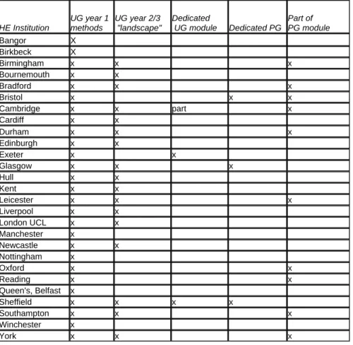
ARS is currently being taught in varying detail at a number of universities (e.g. Campana; Doneus; Gerhard; Gojda; Halkon; Hanson & Brophy; Oltean – all this volume), but in general most do not include it in their general teaching. In some countries, such as Slovenia,
archaeological interpretation is being taught within general aerial photographic interpretation modules (along with geography or civil engineering); there, the multi-disciplinary approach is a bonus in terms of funding attractiveness. A recent general survey of universities teaching archaeology in the UK (Halkon this volume) revealed that teaching staff are well aware of ARS, but that treatment of the topic in courses was highly variable. In many cases coverage is restricted to occasional lectures in general methods courses, with only a few providing dedicated modules. At postgraduate level, the popularity of landscape archaeology in the UK does, at least, ensure that ARS is taught as part of a suite of survey techniques and data sources. It is noteworthy that most UK university archaeology departments do not appear to have ARS specialists on their staff, and this must limit their ability to provide detailed coverage of the subject in undergraduate teaching. Aspects of the UK picture are shared by Germany (Gerhardt this volume), where coverage is very patchy, with little specialist teaching and ARS briefly mentioned in the context of archaeological prospection or tangentially in teaching of prehistoric archaeology. However, it is worth noting that the apparent weakness of formal teaching provision is in contrast to an active aerial archaeological community (e.g. Gerhard this volume and
http://www.univie.ac.at/aarg/php/cms/News/treffen-zur-luftbildarchaeologie-in-deutschland).
Overall, the WP identifies a clear need to promote student exposure to ARS at undergraduate level, to improve awareness throughout the archaeological community of the value of these approaches and best practice in their application. The ARS community needs to take steps to encourage the use of aerial data and examples of its interpretation in university courses, not just in relation to prospection methods but also to landscape archaeology/history, as is the case in Vienna, for example, where most teaching of archaeological prospection is
undergraduate (Doneus this volume) but covers more or less the range of lectures that Glasgow has in its postgraduate programme. The significant synergies that can be gained from integrated teaching of methods need to be emphasised in general teaching for
that have strengths and weaknesses. Archaeologists in general need to have a basic appreciation of these techniques, to be aware of their advantages and disadvantages (e.g. understanding the cultural, physical and environmental processes involved) and to appreciate the value that an ARS specialist can bring into to their work. Moreover, such teaching will provide undergraduates with a foundation for post-graduate ARS courses and/or research using ARS data. Reference to ARS derived data and its origins can also be inserted in
curricula that are structured around a more traditional culture-historical approach, particularly in countries where landscape archaeology is not well established. The need to develop
approaches that are appropriate to particular context is vital and there should be no
presumption that a model of teaching and deployment of ARS, from the UK for example, can simply be applied across the rest of Europe.
In terms of basic deliverables for any undergraduate course a primary focus on the detection of archaeological features is desirable, leaving data acquisition and interpretation for post-graduate courses. All underpost-graduates should understand site formation processes and the relationship between features and soil/landscape etc., for which a landscape-based perspective is most suitable.Issues to be covered should, at the very least, include sensors, platforms,
formation processes, landscapes, chronology and applications (e.g. heritage management). Such a structure may take as its starting point ARS in the context of an application rather than simply a method, in the context of a landscape history case-study and this may make an appreciation of how techniques and data sources may be combined and contrasted easier to grasp.
The apparent general lack of ARS specialists within university teaching staff is not easily addressed. Rather, the WP identifies that existing teaching capacity within universities can be supported to include appropriate ARS content in their teaching. For example, the provision of an internet-based resource for teaching would allow lecturers to download content directly into course materials. Such teaching materials would include both packages illustrating what aerial photographs can do and what they cannot, with good pictorial examples and
explanatory texts (see Beck & Hughesthis volume; and see also Parcak 2009 for a text book with a companion website). This resource could include copyright-free materials (see below under Non Academic and Life-Long Education) and can make use of Google Earth, Grade or Go-Geo existing facilities. It is hoped that such a web-based resource for undergraduate teaching would encourage people over wide areas to stress applicability in their own geographical context, and therefore different case studies from different environmental and cultural areas should be provided. In addition, options within all the issues outlined (i.e. Sensors; Platforms; Formation Processes; Landscapes; Chronology; Applications) could be provided, which would allow a pick-and-mix approach when designing teaching.
Accessibility to this material will need to be quick and easy so that courses can be generated in short order, but also allow for a more in depth case study by picking and choosing other tools. An exemplar of this type of material has been placed on the web with the support of the Higher Education Academy (HEAcademy) subject centre for Archaeology, and is available at: http://www.heacademy.ac.uk/hca/resources/detail/Aerial_archaeology_research_group. It is hoped that this model will stimulate debate about providing such resources and may be built on in future.
AARG membership has a good pool of experienced ARS professionals that could provide these materials, with some quality control to ensure that it meets basic teaching requirements
(e.g. keep it short and to the point) and that it conforms to the general context of the web resource and, very importantly, is copyright free for teaching purposes.
2. Postgraduate training
The WP identifies that postgraduate training has an important role in producing graduates with a well-developed knowledge of ARS and the experience that equips them to develop into future ARS specialists. Considerable variability across Europe in the exposure of
undergraduates to ARS subjects is noted (above) and this has a bearing on the variability in potential scope of postgraduate programmes across the Continent. Alternative routes for producing ARS specialists through workplace experience and continuous professional
development are discussed below (see Non Academic and Life-Long Education). At present across Europe as a whole, it appears that many practitioners with an ARS expertise have a knowledge base that is essentially superficial, rather than deep. Consequently, the number of true ARS specialists is in fact very small and this has clear implications for the discipline. It is the strong view of the WP that proper postgraduate qualifications (Masters) in ARS are required. Such postgraduate teaching will help equip potential PhD students whose research covers ARS topics or derived data with appropriate foundation experience and skills. In the workplace, these courses will also provide the deeper knowledge for future professional archaeologists to better understand the techniques and data, such as aerial photographs that are increasingly routinely being used. The danger of ARS practitioners being perceived as operating at a purely ‘technical’ level must be resisted. Postgraduate qualifications are also important in supporting the development of freelance specialists in the future, as a means of accrediting them in an environment where there is a perception that ‘anyone can do it’. At the date of writing (2009) the Masters ‘Aerial Archaeology’ programme in Glasgow, UK is currently the only taught postgraduate course available (Hanson & Brophy this volume). The course covers techniques, formation processes, photogrammetry, issues of bias and
classification and applications based on interpretation. While much of the teaching is largely traditional photo-based, the contribution of other methods (e.g. Lidar; multispectral and hyperspectral imagery) is being enlarged. The programme includes a work placement during which students gain further training through practical experience in areas such as aerial reconnaissance, cataloguing, interpretation, and cover searches.
The expansion in the provision of postgraduate courses in Europe is desirable, though there is no need for numerous universities to provide this facility (and unrealistic to expect it).
Realistically, it is those university departments which already have ARS specialism on the staff, which should be encouraged to develop postgraduate courses, though in a ‘chicken and egg’ situation they will probably only do so if there is a ‘demand’ from the market-place (e.g. potential students and potential employers). These universities may wish to support such developments by establishing specialist ‘Centres’ (below).
Shared expertise is important in solving problems of getting specific specialists on courses, while remote delivery is also clearly a way forward, using facilities such as Access Grid to share lectures (e.g. Gaffney 2007). In addition, the Erasmus scheme should be able to continue to help student mobility to Universities which provide specialised training not available in their home Universities and even support work placements (university-to-company, i.e. the former Leonardo da Vinci programme: e.g. Sokołowska 2008). In parallel, Masters
programmes on cognate subjects (e.g. landscape archaeology, cultural heritage management, etc.) taught in Universities will be encouraged to provide information for future specialist
users of ARS products through proposed web teaching materials. Less formal, but equally vital, is that university staff who take on postgraduate researchers utilising ARS data ensure that these students have appropriate experience and skills to utilise their source material.
3. ARS Centres
The WP supports the creation of a network of university departments and potentially other affiliated organisations as Centres with a specialism in ARS. This is seen as a means of coordinating many of the issues discussed above: agreeing, sharing and maintaining
standards, promoting research and providing a ‘critical mass’ of expertise for teaching. These Centres could/should host web material derived from AARG as discussed above, and may provide some degree of permanence to avoid problems of an infrastructure crumbling when an individual leaves. Such Centres should be established in a University context as
Government Agencies do not always have the priorities or the resources for research or extensive academic outreach. Affiliations, or an informal relationship between universities and such agencies, which may employ many ARS specialists is to be encouraged. Proposed centres may operate best on a regional or language basis rather than along national lines. The WP would encourage the creation of a framework of such Centres as a forum to facilitate applications for funding, exchanges of personnel, research collaboration and so on.
Such Centres may provide a formal means of making connections into other organisations, such as the Special Interest Group on Remote Sensing and Archaeology, which has been set up by the Italian National Council for Research through its Institute for Archaeological and Architectural Heritage (Istituto per i beni archeologici e monumentali). This group, who are primarily specialists in Remote Sensing rather than archaeology (sensu stricto), share obvious common ground with ARS and there are evident synergies in collaboration. The University of Glasgow, UK, has now set up the ‘Centre for Aerial Archaeology’ with the stated purpose of providing a centre of excellence for teaching and research in aerial archaeology, to act as a focus for research grant applications, and to encourage links with other institutions (Hanson 2008). In August 2008, an Aerial Archaeology Unit was set up in the Institute of Prehistory, Adam Mickiewicz University in Poznań, Poland (Rączkowski 2009). Its aims emphasise the interdisciplinary use of non-invasive remote sensing techniques (i.e. aerial photography, satellite imagery or laser scanning) in the study, management and protection of the cultural heritage, especially in a landscape context. The exploration of the theoretical basis for the application of remote sensing methods in archaeology is highlighted, and alongside the aim of participating in the development of academic archaeology teaching in European universities, participation in projects preparing educational materials for schools also attaches some importance.
The WP supports such initiatives though it recognises that single initiatives are undoubtedly vulnerable to changes in staffing and University politics. Centres must also be seen to be productive as there is some cynicism amongst funding bodies to organisations that appear to be little more than paper exercises. However, a loosely affiliated network of Centres would provide strength in depth and greater kudos when dealing with senior management or politicians. Moreover, international cooperation is very much at the forefront of academic thinking at senior levels in Universities.
Non Academic and Life-Long Education
This section includes formal, informal and workplace education for all ages from children to adults. It includes professionals, the general public, children in schools and young adults in further education institutions (other than universities). The aims of life-long education are: to improve knowledge, competence and expertise; attain national targets in skills and
qualifications; raise teaching/ learning standards; and widen participation and access. This overview examines the contexts where aerial photographs and derived data can be used, primarily in its application to studying archaeology, but also in related subjects. It identifies approaches to broadening access to using aerial photographs for these target audiences, each of whom specific needs have. Although, contributions from AARG Education WP members attempted to broaden the perspective beyond the United Kingdom (UK) to Europe, this overview is not comprehensive.
1. Professional Training
The WP has identified an often low knowledge base amongst professional archaeologists about ARS and the application of derived data. The importance of ARS specialists and researchers presenting their work to archaeology and heritage management professionals via conferences, particularly large ones such as EAA with Landscape archaeology papers is stressed. Some European countries, such as Slovenia and Romania, have annual report meetings when archaeologists get together to present recent work, and these too are good opportunities for spreading the word.
However, the wider provision of professional courses for those out with the formal education system is identified as of potential benefit to the profession (Boutwood & Winton this
volume). Professionals use continuous professional development (CDP) to improve their knowledge, competence and expertise and to attain new skills and qualifications. This benefits individuals, employers and the archaeological profession. The Institute of Field
Archaeologists (IFA), who has members in the UK and Europe recommends at least fifty hours CDP over a two-year period for its members. This includes attending training courses, workshops and conferences, or attaining new skills by on the job training and job shadowing. Any of these may lead to attaining new qualifications and is an effective vehicle for acquiring skills in using aerial photographs and other remote sensing data, such as Lidar.
There are very few courses available, which specifically include training in using aerial photographs. Oxford University Department of Continuing Education (OUDCE) is one of the leading establishments in UK providing professional training in the historic environment. A two-day course in aerial photography includes interpretation and mapping and applications to landscape studies. Participants come from a wide range of backgrounds and it caters for archaeologists and historic environment professionals, both as consumers of ARS mapping data and those trying to interpret aerial photographs themselves. The course counts for the CDP requirement for the IFA. Apart from the OUDCE course at Rewley House, Oxford, there are few other courses in Britain that cater for professionals, as it relies on having expert tutors to deliver the courses. In Europe there appear to be no equivalent institutions and courses of this nature available. TORC (Training on-line Resource Centre for Archaeology
http://www.torc.org.uk/), lists archaeology and related courses in the UK and PLOTEUS (Portal on Learning Opportunities throughout the European Space
http://ec.europa.eu/ploteus/) is a similar European database. We need to ensure that any courses on ARS are listed on these databases.
AARG members have specialist needs in their professional development as they have to keep up to date with developments in ARS work and other remote sensing techniques. The annual AARG conference and more specialised workshops organised by AARG and others provide a forum to share knowledge and expertise (e.g. Campana; Helles Olesen; Musson & Palmer – all this volume). To reach a wider audience, conferences that target archaeologists, for example those organised by the European Association Archaeologists (EAA) and annual meetings in Slovenia and Romania, provide an opportunity to broaden awareness by presenting papers on aerial photography and landscape studies.
Work placements provide an opportunity to train people on the job, working alongside specialists. In the UK workplace learning bursaries in archaeology and heritage management are designed and administered by the IFA. In English Heritage, EPPIC placements (English Heritage Professional Placement in Conservation) train for one-year in architecture, field investigation or aerial survey. The latter is an effective means of acquiring aerial photographic interpretation skills and applying them to a variety of landscapes. These placements are funded by English Heritage, the IFA and the Heritage Lottery Fund (HLF) and improve candidates’ employability status. The work undertaken can be used to attain National Vocational Qualifications (NVQ) in Archaeological Practice.
2. The General Public
The general public includes amateur archaeologists and community groups, who often have an interest in their local history and archaeology. Such groups are flourishing and there is a variety of ways to engage with them. In Britain presentations through media, such as television programmes (e.g. Time Team and Time Flyers) have had a huge impact on stimulating interest in studying local history and archaeology. Displays at heritage sites and museums, conferences and talks to societies, provide an opportunity to use aerial photographs and raise awareness. More specialist needs can be catered for by providing workshops and courses, but the provision of these is dependent on local circumstances, as to whether
specialists are available to teach courses. Dedicated Community Archaeologists, supported by the Heritage Lottery Fund, provide free workshops on all aspects archaeological investigation including using aerial photographs.
In many European countries national curricula for school children (ages 5-18) provide guidelines for teachers. They vary in their approach to being prescriptive on certain topics and/ or offering recommendations on aspects of teaching, such as methodological approaches. Influences may be localised, for example in Germany where education is the responsibility of the federal states, or national, in the case of England, or international, where organisations like UNESCO may have an influence on education. In the UK there is some flexibility in teaching in schools and using aerial photographs can be adapted to a wide range of subjects, not just history and geography.
Further education colleges (students over 16 years) are autonomous independent institutions, which cater for vocational training and can set their own curricula. The course content and lecturers may not be validated, but some courses in the UK are accredited by the National Open College Network (NOCN) and these have strict standards and syllabi. Although syllabi
set topics for study, there is some flexibility to introduce case studies, which are a useful resource for teachers. It is in this context that advanced level archaeology and archaeological science is taught. Students need to demonstrate appreciation of all forms of archaeological evidence and survey including aerial photography and other forms of remote sensing.
3. Schools
There are two approaches to consider promoting the use of aerial photographs in schools and colleges. Firstly, there is a need to train teachers and raise awareness of the potential of using aerial photography in a wide range of subjects. The framework for teachers’ professional development exists through In Service Training (INSET) courses in the UK and Europe, but courses in using aerial photography are rarely offered. In the UK organisations who promote archaeology, like the Council for British Archaeology (CBA), strive for the recognition of archaeology in the UK education system. One-off workshops on using aerial photographs have been delivered at the CBA Education Conference, which attracts teachers, outreach officers and museum staff. Secondly, there is a need to improve the availability of suitable teaching resources that include aerial photography. Many standard textbooks may be out of date, but more specialised topic information is becoming more readily available in
publications. For example an English Heritage Teachers’ handbook includes resources and aerial photographs, on a CD, which contains case studies linked to the national curriculum. Copyright restrictions have been lifted for use in schools and this is crucial to promote the use of aerial photographs.
Another approach is to widen the range of teaching resources available via the web. Material can be downloaded, without copyright restrictions if used for education purposes and this needs to be extended to aerial photographs. In the UK this has revolutionised the way information is accessed and shared by education professionals, but in some European countries resources are not shared via this medium. In the UK there is an abundance of web sites (e.g. TeacherNet http://www.teachernet.gov.uk/) and some network providers already include aerial photographs (e.g. InfoMapper in association with South West Grid for
Learning, has aerial photographs, maps, satellite photography and other resources). In the UK heritage agency web sites already have resources available to teachers and the inclusion of aerial photography is expanding. To encourage other European countries to develop sites with resources, there is a need for web providers to facilitate this. Sites like the Golden Web (http://www.goldenweb.org/), which is a world history internet project that can link material in any language, could potentially facilitate this. However, this can only be effective if
teachers, or other professionals in European countries, collate and share resource material and provide case studies that include aerial photographs.
It is also appropriate to consider other contexts, such as museums and social contexts where children and youth groups engage in activities relating to archaeology. In all of these contexts educating the teachers, lecturers, youth leaders and outreach officers is the most effective way of promoting the use of aerial photography. In the UK the Young Archaeologists (YAC) already has good links to professionals that have introduced leaders to using aerial
photographs. Similarly, in Poland out of school workshops have the benefit of professionals familiar with aerial photography. Exhibitions and museums displays can be enhanced by using aerial photography. Interactive displays can also be socially inclusive, as seen at an exhibition at the Natural History Museum in London, where aerial photographs were adapted for the blind.
References
Gaffney, C. 2007 Access Grid Seminars AARGnews 34 (March 2007), 28-9
Hanson, W. S. 2008 The Centre for Aerial Archaeology, Department of Archaeology, University of Glasgow, AARGnews 37 (September 2008), 12-14
Parcak, S. H. 2009 Satellite Remote Sensing for Archaeology, Routledge
Rączkowski, W. 2009 In the shadow of crisis: Chairman’s Piece, AARGnews 38 (March 2009), 5-8
Sokołowska, A. 2008 Erasmus Student Placement Programme 2007/08 – facts and thoughts from the student’s point of view, AARGnews 36 (March 2008), 49
Appendix 1: Membership of the AARG/EAC Working Party on Education
Dr Ioana Oltean (Chair; University of Exeter, UK)
Dr Cinzia Bacilieri (UK & Italy)
Dr Anthony Beck (University of Leeds, UK)
Yvonne Boutwood (English Heritage, UK)
Dave Cowley (AARG, RCAHMS & Chair of AARG/EAC Aerial Archaeology WP)
Dr Michael Doneus (Institut f.Ur-und Fruehgeschichte, Vienna, Austria)
Dr Susanne Gerhard (State Authority for Culture and Preservation of Monuments, Department of Archaeology, Schwerin, Germany)
Professor Darja Grosman (University of Ljubljana, Slovenia)
Professor W. S. Hanson (University of Glasgow, UK)
Chris Musson (Aber Photo Services, Wales, UK)
Rog Palmer (AirPhoto Services, Cambridge, UK)
Sólborg Una Pálsdóttir (The Archaeological Heritage Agency of Iceland)
Teaching aerial archaeology and remote sensing for landscape archaeology
at the University of Siena (Italy)
Stefano Campana
The history of aerial archaeology studies at the Department of Archaeology and History of Arts of the Siena University dates back to the mid-1980s. In 1984, Professor Riccardo Francovich in collaboration with a photo interpreter, Marcello Cosci, started a programme of aerial
reconnaissance in Tuscany and Umbria. At about the same time Professor Francovich set up an undergraduate course in aerial archaeology. The approach emphasised the analysis of vertical aerial photographs stored in the archives of the Military Survey (IGM collection dating back to the 1930s, 1950s and 1960s) and of the Tuscan and Umbria Region Survey Bureau. In this manner, they identified a huge number of archaeological sites, especially medieval hillforts and Neolithic and Bronze Age enclosures. A significant development in approach took place in 1999 when Professor Francovich organized an International Summer School on Remote Sensing in Archaeology. After that event, new approaches based on the integration of different prospection methods have been developed by a new Laboratory established by Francovich and the author: The Landscape Archaeology and Remote Sensing LAB
(http://www.lapetlab.it/indexE.html).
In 2000, in anticipation of imminent changes in Italian law on aerial photography, the possibility of organizing an aerial survey training course in Siena was discussed with two colleagues from Britain - Chris Musson, from Wales, and Robert Bewley, then Head of Aerial Survey at English Heritage. In the spring of 2000 we carried out preliminary aerial
reconnaissance to check at first hand the potential and limitations of oblique aerial photography in the landscape of Tuscany. Then, at the end of May 2001, twenty-one post-graduate students engaged in the areas of research and heritage conservation took part in the first Aerial
Archaeology Research School to be held in Italy. In addition to instruction in aerial survey and photo interpretation, a further objective of the school was to start building up an archive of oblique aerial photographs for the recording of the archaeological resource throughout
Tuscany. Progressively additional expertise and tools for archaeological prospection have been developed. In February 2001 we began to build up our experience in the use of High
Resolution Satellite Imagery. The aim was the evaluation of multispectral data for
archaeological research, firstly using Ikonos-2 imagery and then from June 2002 working on QuickBird-2 imagery. In May 2001 we started applying geophysical survey methods to better understand archaeological sites. In 2005, through a Culture 2000 project of the European Union, entitled European Landscapes: past, present and future, the University of Siena took its first steps in LiDAR data acquisition, processing and interpreting for four sample areas in the provinces of Siena and Grosseto. This was made possible through the good services of colleagues in England at the Natural Environment Research Council and the Unit for Landscape Modelling at the University of Cambridge. The results were processed in collaboration with the Department of Geography at Durham University (UK) under the supervision of Professor Daniel Donoghue and Dr Nikolaos Galiatsatos.
We have added geophysical prospection (mainly magnetometry, but also sometimes Ground Penetrating Radar and electrical prospection methods) to our suite of methods for the
examination of archaeological sites. Building on this approach we have also started a
Pickering (Powlesland 2009), of large scale continuous geophysics aimed at exploring systematically the landscape including traditionally blank areas between traditional sites, highlighting the potential of the off-site record in a landscape-based approach (e.g. see papers in Campana & Piro 2009).
Undergraduate teaching
At present, the University of Siena gives two lecture courses on aerial archaeology and remote sensing, which are repeated annually in modules of 30 hours each, on “Landscape Archaeology” and “Landscape Archaeology and Remote Sensing”. The courses provide a brief introduction to the history of remote sensing in archaeology, focusing on the
development of applications to the study archaeological sites and landscapes. In detail, we address the following issues:
• Satellite archaeology
• Aerial archaeology
Archaeological mapping: integration of different detection methods allows us to put the jigsaw puzzle of the landscape together. We can measure and position each piece of information while at the same time perceiving the overall picture, whether synchronically or diachronically.
• Airborne scanners (hyperspectral scanners, LiDAR)
• Aerial survey and oblique aerial photography
• Geophysical prospection
• Aerial and ground archaeological “visibility” with particular regard to emptiness
Doctoral research
The Department Archaeology and History of Arts also has doctoral programmes on landscape archaeology and remote sensing, focusing particularly on data integration aimed at facing methodological issues systematically joined with well defined archaeological and
historiographical problems. Recent successful theses have included Emanuele Vaccaro (2007), Cristina Felici (2008) and Federica Boschi (2009).
International Summer Schools program
The International Summer School in Archaeology is a well-established interdisciplinary event. Established by Professor Francovich and Professor Daniele Manacorda in 1987, it serves as an interface between experts in archaeology, cultural heritage, art history and those from remote sensing, photogrammetry, CAD, spatial information science, computer graphics, virtual reality, etc. The Schools have an international audience, extended discussion between participants, and direct relationship between teachers and students.
The University of Siena has the leading role in Italy in the organization of the International Summer School. After more than twenty years of meetings the School still presents one of the most important opportunities for fostering and advancing working relationships between archaeology and related disciplines. The Summer Schools have dealt with themes which have created important initiatives and international debate aimed at advancing archaeological work in Italy and beyond. In general the Schools involve teaching concerned with archaeology in practice and with the use of interdisciplinary techniques. The range of issues related to remote sensing and landscape archaeology addressed by the Summer Schools over the years can be seen in this listing:
1991 - Landscape Archaeology
1995 - Information Systems and Geographical Networks in archaeology: GIS-Internet 1999 - Remote Sensing in Archaeology
2001 - Aerial Archaeology Research School (Culture 2000 project) 2005 - Aerial Survey, Digital photography and GIS-based interpretation
archaeological (Culture 2000 project) 2006 - Geophysics for Landscape Archaeology
2007 - Exploring Archaeological Landscapes: from Archaeological Record to Virtual Reality
2008 - 3D modelling in Archaeology and Cultural Heritage (in collaboration with ETH-Zurich, BKF Trento, University of California Merced)
2009 - Training education on Geophysics for Archaeology: surveying methods, elaboration and 2D and 3D representation (in collaboration with ITABC-CNR) 2009 - 3D modelling in Archaeology and Cultural Heritage (in collaboration with
Integrated approaches to archaeological prospection and further developments
The University of Siena has a long history of teaching aerial archaeology and remote sensing, developing an integrated approach to prospection in a landscape context through its
Landscape Archaeology and Remote Sensing LAB. This approach is an integral part of its undergraduate and postgraduate programmes, extending also into a leading role in organising international summer schools and international workshops.
The importance and the impact of our experience might be, probably, better followed and understood through our main publications:
• Campana S. & Forte M. (eds) 2001, Remote Sensing in Archaeology, proceedings of the XI International School in Archaeology, (Certosa di Pontignano, 6-11 dicembre 1999), All’Insegna del Giglio, Firenze
• Campana S. & Francovich R. (eds) 2006, Laser scanner e GPS: paesaggi archeologici e tecnologie digitali 1, atti del workshop, 3 marzo 2005 Grosseto, All’Insegna del Giglio, Firenze
• Campana S. & Forte M. (eds) 2006, From Space To Place, Proceedings of the 2nd International Conference Remote Sensing Archaeology, Rome (December 4-7 2006), Archaeopress BAR International Series
• Campana S. & Piro S. (eds) 2009
• Musson C., Palmer R. & Campana S. 2005, In volo nel passato. Aerofotografia e cartografia archeologica, All’Insegna del Giglio
The experience of the Department and of the LAB in teaching, archaeological research and fieldwork (landscape, test-areas, excavations) has prompted us to start a spin-off company ATS (Archaeolandscapes Tech & Survey - www.atsenterprise.com) of the University of Siena aimed firstly to commercial archaeological prospection, which gives our students an
opportunity to carry on their skills.
References
Boschi, F. 2009 Tecniche di telerilevamento per l'archeologia dei paesaggi tra tardoantico e altomedioevo: il caso di Classe, PhD Thesis, University of Siena
Campana S. & Piro S. (eds) 2009 Seeing the unseen. Geophysics and Landscape Archaeology, Proceedings of the XVth International Summer School, Taylor & Francis, London
Felici, C. 2008 Processi di trasformazione dell'insediamento rurale tra V e VIII secolo d.C. nella provincia senese. Un esempio di sinergia fra ricerca archeologica e fonti documentarie, PhD Thesis, University of Siena
Powlesland, D. 2009 Why bother? Large scale geomagnetic survey and the quest for "Real Archaeology", in Campana S. & Piro S. (eds) 2009
Vaccaro, E. 2007 Processi di trasformazione insediativa, gestione del territorio e circolazione ceramica nella Maremma costiera tra IV e XIV secolo d.C. Per una definizione dei rapporti politici e socio-economici tra città e campagna tra tardoantichità e medioevo: i casi della bassa valle dell’Ombrone e della valle dell’Osa (GR), PhD Thesis, University of Siena
Students at Rosia (Italy) in 2001 working together on the necessary task of locating on a map the aerial photographs they had taken the day before.
Teaching non-invasive archaeological methods at the University of Vienna
Michael DoneusIn Austria, the importance of prospection using the non-invasive methods of aerial archaeology and remote sensing, airborne laserscanning, and geophysical prospecting is constantly increasing in archaeological work. The development of aerial archaeological prospection in Austria has mainly taken place at the University of Vienna, where in 1992 the Department of Prehistoric and Medieval Archaeology (www.univie.ac.at/urgeschichte) created a full-time job for an aerial archaeologist. In 1994 the Vienna Institute for
Archaeological Science (VIAS) was founded, which now also offers part-time jobs in aerial archaeology and archaeological geophysical prospecting. The offices of both are located at the Department of Prehistoric and Medieval Archaeology. This enables us to establish a close cooperation between aerial archaeology and geophysical prospection.
In Vienna, research and education go hand in hand, and lectures on prospection techniques have become a vital part of our student curricula over the last 15 years. Therefore, lectures in aerial archaeology and geophysical prospection are given by specialists of the respective fields. There has always been a consent at the department that teaching archaeological prospection has to start at the undergraduate level. Therefore, the basics of both aerial
archaeology and geophysical prospection are already lectured within the introductory module, which is obligatory for every student.
Besides that, the Department of Prehistoric and Medieval Archaeology offers two modules, in which archaeological prospection is lectured in the context of landscape archaeology. The module ‘prospection techniques and landscape archaeology’ is part of the Bachelors
curriculum. At the moment, among others it contains lectures on archaeological stratigraphy, GIS, archaeological interpretation of aerial photographs and geopphysical prospection techniques. The module ‘landscape archaeology’ is part of the Masters curriculum and imparts e.g. air photo interpretation and landscape archaeology, and theory and practice of geophysical prospection.
Going into more detail, the lectures on aerial archaeology cover:
1. Basics of aerial archaeology. This lecture is part of the Bachelors curriculum and obligatory for all students. It imparts basic information such as the history, application, and limitations of aerial archaeology, formation of sites and visibility marks, production and use of vertical and oblique aerial photography, etc.
2. Archaeological interpretation of aerial photographs. Again, this lecture is part of the Bachelors curriculum. It focuses on the different phases of aerial archaeological interpretation (oblique reconnaissance, photo reading, mapping) giving theoretical information on the principles of remote sensing, perception, hermeneutics, as well as practical information on how to interpret, which instruments to use, etc.
3. Aerial photo interpretation and landscape archaeology. As part of the Masters curriculum, this lecture bridges the gap between aerial archaeology and all kinds of spatial archaeology. After a theoretical introduction students learn how to rectify and map aerial photographs and in that way to systematically collect basic archaeological data for further spatial analysis.
In the near future, there will be an additional lecture on airborne laserscanning. Other modules also contain lectures on surveying, photogrammetry and CAD. All of them are part of the standard curriculum of each student.
The current curriculum for both Bachelor and Master can be found at the following link: http://spl.univie.ac.at/index.php?id=33714.
The current university calendar is presented at:
http://online.univie.ac.at/vlvz?lang=de&kapitel=601&semester=current.
~~~~~~~~~~~~~
Demonstrating use of an early version of the specialist program AirPhoto to students, most of whom worked for the national conservation body, at Leszno (Poland) in 1998.
Aerial archaeology in German universities
Susanne GerhardThis short note arises from research undertaken in 2007 on the provision of aerial archaeology teaching in German Universities. The data gathered only cover the academic year 2007 but include all 24 departments of (prehistoric) archaeology.
For the most part aerial archaeology seems to be taught only very briefly, partly in lectures (Vorlesungen) and partly in seminars (which can include student presentations as well as those by staff). Only Bochum (Baoquan Song) and Mainz (Peter Haupt) have an aerial archaeological practitioner on the staff.
The method of instruction varies considerably. Prospection methods may be mentioned among a multiplicity of other subjects. Jena, Kiel, Mainz, Muenchen and Muenster make or made use of external staff to present seminars that have a practical emphasis. Examples include Ralf Schwarz presenting on Aerial Archaeology in Mitteldeutschland and Walter Irlinger on Basics of remote sensing – geophysics and aerial archaeology. In both these examples the seminars are presented by staff of local heritage bodies.
However, while it the provision of formal teaching may not be encouraging, it is very far from the entire picture. On the initiative of Johanna Dreßler, a post-graduate student at Mainz, the German “community” is on the point of creating something more formal. A first meeting in Mainz in December 2008
(http://www.univie.ac.at/aarg/php/cms/News/treffen-zur-luftbildarchaeologie-in-deutschland), bringing together university teachers and students as well as heritage people, freelancers and volunteers, was very inspiring and ended with the idea to have a common website (perhaps hosted by the Institute of Pre- and Protohistory of Mainz University).
~~~~~~~~~~~~~
Courses in aerial archaeology at universities in the Czech Republic:
an overview
Martin Gojda
Origins and History
The history of teaching aerial archaeology at universities in the Czech Republic dates back to the mid-1990s. Ten years earlier – still under the Communist rule – the Moravian researchers J. Kovárník (archaeologist) and M. Bálek (geodesist) took the first steps in the area of aerial survey, independent of each other. Their approach consisted primarily of the analysis of vertical aerial photographs stored in the archives of the Military Topographic Institute (the oldest photographs in this collection dating back to the 1930s). In this manner, they identified several archaeological sites, especially large enclosures dating to the Neolithic and Bronze Age. They also managed to take several survey flights over South Moravia, despite
considerable legislative and administrative obstacles.
The first to initiate a course in aerial archaeology in the Czech Republic was M. Bálek of Masaryk University in Brno. His one-term (semester) course had been on offer among the optional courses at the University Institute of Archaeology and Museum Studies since 1996, and M. Bálek taught it until 2003 (Gojda 1998). Besides the theoretical coursework, he managed on several occasions to organize end-of-term one-day practical training in aerial survey, with his students taking one prospection flight in the Morava and Dyje river basins (in 1998-2000, the Institute of Archaeology AV ČR in Prague provided its manned survey
aircraft for this purpose). After M. Bálek’s death, the author of this contribution was asked to continue the aerial archaeology course at Masaryk University and he has been teaching it to this day (the course runs every other year).
Between 1999 and 2001 aerial archaeology was also included in the options at the Institute of Prehistory and Early History of Charles University in Prague while being simultaneously run, this time as a compulsory course, by the Department of Archaeology at the University of West Bohemia (henceforth DA/UWB). In both cases, the one-term course was complemented with one-day practical training in an aircraft.
Current Teaching and Training
At present, only Pilsen University is providing a complete (theoretical as well as practical) course in remote sensing in archaeology (henceforth RSA) in the Czech Republic. This compulsory course is attended by second-year students of the Bachelor degree in the winter term of the academic year. It follows on from the subject of Non-destructive Archaeology, which is taken by first-year students, offering a basic overview of the mission, goals and methods of non-destructive procedures in current archaeological research.
A total of 12 two-hour lectures are divided into the following units: 1. Introduction to RSA
2. Past and present of RSA
3. Heuristics/data collection – basics of visual low altitude aerial survey in archaeology (equipment and tools, crew work during flight, methods of recording and documenting
identified sources), basics of aerial photography of historical landscape or earthworks, architecture and urban complexes
4. The principles of how we see buried or upstanding archaeological features from the air (e.g cropmarks, soilmarks, shadowmarks)
5. Data processing
6. Basics of remote sensing of the Earth and use of the products of high-altitude photogrammetric aerial photography and satellite survey (orthophotos, satellite images, and airborne laser scanner data)
The remainder of the theoretical part of the course is devoted to geophysics in archaeological research (R. Křivánek, Institute of Archaeology, Czech Academy of Sciences). The main reason for its inclusion in the course in RSA is its extensive use in verifying and locating features/sites identified by aerial prospecting on the Czech territory over the past decade or so.
Practical Training
The extended practical part of the course has been taking place on a regular basis since 2004. Depending on conditions, it lasts one or two weeks, mostly in June, when the number of places displaying cropmarks on growing plants are highest (besides winter crops, cropmarks show on spring crops as well). Besides second-year undergraduates, the course can also be attended by first-year graduates. In both cases, the students’ participation in the practical part of the course in aerial archaeology is optional, the capacity of the department usually making it impossible to satisfy all those interested in taking part. It mostly takes place in the area of a solitary hill of Říp (in recent years mainly because the DA/UWB has been conducting
research into the local prehistoric/medieval settlement (see Gojda 2007). This area has, due to the wealth of prehistoric settlement made visible as cropmarks, become a sought-after area for efficiently conducted aerial archaeological training of our students. The high density of sites (several dozen) on a relatively small area (about 100 km2) ensures considerable efficiency of survey flights, even in the cases when, in recent years, cropmarks over archaeological
monuments have been appearing less markedly or less frequently for objective reasons. These courses are based at the airfield of the Aeroklub of the Czech Republic in Sazená, which provides important background for the practical part of the course (takeoffs and landings several times a day on a high-quality grass runway), the groundwork (a classroom for pre-flight preparation and the processing of data acquired during survey pre-flights) as well as for other needs related to students’ training (e.g. projection of photographs and footage) and accommodation.
The training itself mostly involves groups of 5-6 students, who make up two crews, taking turns in two-day cycles. As allowed by circumstances, each crew takes one short introductory flight and, one or two longer survey flights. During these, students carry out visual monitoring of terrain surface, identification of places with cropmarks and their subsequent photographic documentation. In addition, they learn continuous navigation by means of paper maps, operating the GPS station (route recording, saving the location of points of interest, or more precisely the discovered sites) and they enter the flight data (including key information about the individual photographed areas) in a special paper form. Each student thus has an
opportunity to become acquainted with activities that need to be continuously conducted during survey. In the classroom (immediately after landing), the crews download digital data from cameras and the GPS station to a computer, where they work further on them, identify
the exact location of sites by comparing map and GPS station data with photographs, editing, evaluating and finally saving them to a database.
Survey flights are conducted in a Cessna 172 aircraft (OK-EKD), owned since 1997 by the Institute of Archaeology, Academy of Sciences of the Czech Republic. Its operator T. Janíček (Paraklub Praha–Letňany) participates in the courses not only as pilot but also to co-ordinate crew members during flight. The aerial archaeological training was also repeatedly joined by Z. Smrž from the Archaeological Institute (Most) in the years 2005 and 2008, when the one-week courses took place in Northwest Bohemia, or more precisely in the Podkrušnohoří and Poohří regions (the basis being the Chomutov airfield). For completeness’ sake, let us add that in 2004, the courses took place in West and East Bohemia (airfields Plasy and Dvůr Králové n. L.).
New Developments
Since the summer term of the academic year 2008-09, the teaching of RSA at the Pilsen Department will be enriched with special lessons devoted to the analysis and interpretation of vertical aerial images. Besides an introduction to the work with contact photographs, the course will be aimed at the analysis of digital data by means of special software enabling effective three-dimensional visualization of stereopairs of aerial photogrammetric images and their subsequent interpretation. These lessons are included in the compulsory course on Landscape Archaeology, which opens in the first year of the Master’s (graduate) study programme.
The year 2009 will also see the first opening of an elective course in RSA, taught by the author of the contribution, at the Archaeology Section of the History Department of Palacký University in Olomouc. An abridged version of this course was taught – within the subject of Non-destructive Archaeology – abroad, at the Comenius University in Bratislava in 1998-2000. Since 2006, it has also been taken by students of Cardinal Stefan Wyszyński University in Warsaw, Poland.
References
Gojda, M. 1998 Letecká archeologie: mezinárodní spolupráce a letní výcvikové kurzy, Archeologické rozhledy 50/4, 869-876.
Gojda, M. 2007 Archeologie krajiny Podřipska. Cíle, metody a výsledky prvního roku
projektu. In, Krištuf, P., Šmejda, L. & Vařeka, P. (eds) Opomíjená archeologie 2005 – 2006, Plzeň, 12-18.
The airfield Sazená (on the border between central and north Bohemia, 30 kilometres north of Prague) where most of the aerial archaeology courses organized by DA/UWB take place.
A group of students standing in front of the Cessna 172, OK-EKD, just a few moments before the start of a reconnaissance flight over the region of the Říp.